
More news on this day
A British safety-technology company, Tended, is working with the European Space Agency on a virtual worksite solution that uses space-derived positioning and data services to reshape how railway construction projects are planned and delivered across Europe.
Get the latest news straight to your inbox!
Space-Derived Technology Meets Trackside Reality
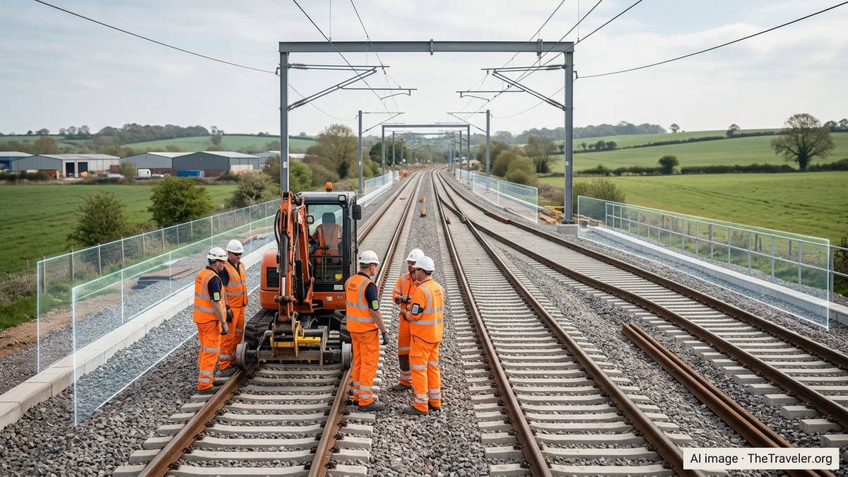
Publicly available information shows that Tended, a Lincoln-based safety technology company, has been collaborating with the European Space Agency through its Business Applications and Space Solutions programme to adapt satellite navigation and space data for complex rail environments. The initiative is focused on turning the traditional construction worksite into a digital twin, where precise geolocation, rules and safety boundaries can be tested virtually before any boots reach the ballast.
The partnership aims to bring the accuracy and reliability associated with satellite-enabled systems to the highly regulated world of railway construction. Instead of relying solely on paper plans, radio calls and line-side signage, project teams can define detailed virtual worksites in advance, then synchronise those plans with connected devices and cloud platforms. This approach is designed to improve situational awareness for workers and contractors, while giving infrastructure managers a clearer picture of what is happening on or near the line.
According to published coverage of the collaboration, the system draws on satellite positioning, communications and data analytics techniques originally proven in space and navigation projects. By packaging those capabilities into a rail-ready platform, Tended’s virtual worksite concept is intended to reduce the risk of workers or machinery entering unsafe zones, particularly in locations with complex track layouts, junctions and short access windows.
How the Virtual Worksite Concept Works
The virtual worksite solution allows planners to define digital boundaries that mirror the physical limits of a worksite, including safe access routes, exclusion zones and the precise extents of track possessions. These geofenced areas are set out on a digital map long before teams arrive on site, using detailed infrastructure data and satellite-based positioning to achieve track-level accuracy.
Once the virtual worksite is configured, it can be deployed to wearable devices or other connected hardware used by track workers and supervisors. When a person or item of plant approaches the edge of the authorised zone, the system can trigger escalating alerts to prompt corrective action. Reports indicate that this method is being promoted as a way to support established safe systems of work rather than replace them, adding an additional digital layer of control.
The same virtual boundaries can also be used to coordinate plant movements and reduce conflicts between different teams. In busy upgrade schemes where overhead line work, track renewals and signalling installations happen in close proximity, the platform can highlight overlaps or clashes in advance. This enables planners to adjust logistics and sequencing before the access period, cutting the risk of last-minute changes that often lead to delays and cost overruns.
Because the worksite exists digitally, it can be simulated repeatedly using different access strategies and resource plans. This allows managers to compare options for staging, staff deployment and line closures, with the goal of selecting the arrangement that strikes the best balance between safety, productivity and disruption to rail services.
Safety, Efficiency and the Push to Digitise Rail
The collaboration between Tended and the European Space Agency comes at a time when rail infrastructure owners across Europe are looking to digital tools to improve both safety performance and delivery certainty. Railway construction remains a high-risk environment where workers operate in close proximity to live lines, heavy machinery and moving trains. Geofencing and virtual worksite technologies have been emerging in response, offering real-time, location-aware safeguards that complement traditional procedures.
Recent industry guidance and case studies highlight growing interest in using such systems to provide workers with clearer feedback about their location relative to live lines, adjacent open tracks and restricted zones. By linking the virtual worksite to planning standards and local rules, project teams can check that access points, safe walkways and plant positions are consistent with approved documentation before they are used in the field.
From an efficiency standpoint, the digital representation of the worksite gives contractors and rail operators improved visibility of who and what is on the railway at any time. This can help reduce set-up times at the start of a shift, avoid duplicated protection measures and support faster handback when possession ends. For rail passengers, the expectation is that more predictable construction windows and fewer overruns will translate into a more reliable service and fewer short-notice timetable changes.
The push toward virtual worksites also dovetails with broader efforts to create digital twins of rail corridors, combining construction planning, signalling data and asset condition information. In that context, the Tended and ESA collaboration is part of a wider move to embed satellite-enabled location accuracy and space-based services within the everyday toolbox of rail project managers and engineers.
Implications for Future Rail Projects Across Europe
As the virtual worksite concept gains traction, rail organisations in the United Kingdom and mainland Europe are assessing how such systems could be built into new projects and renewals portfolios. According to publicly available material, Tended’s technology has already been trialled on several rail networks, providing early insight into the operational changes required to integrate digital boundaries into established planning and safety processes.
For infrastructure managers, one potential advantage lies in being able to standardise how worksite limits and access rules are defined across their networks. Instead of each project team interpreting diagrams in slightly different ways, a central digital template could be issued that sets the parameters for safe access and plant working. Over time, this could support more consistent application of safety rules and reduce the risk of misunderstandings between clients and contractors.
Contractors, meanwhile, may see benefits in training and onboarding. With a virtual worksite available ahead of time, new staff can be walked through the layout of a possession, the location of welfare facilities and escape routes using digital maps or simulation tools. This has the potential to shorten familiarisation periods, particularly for workers moving between geographically dispersed projects or international assignments.
For the wider rail travel sector, the longer-term impact of space-tech powered planning could be felt in reduced disruption as major enhancement schemes proceed. If construction windows are more tightly controlled and overruns become less frequent, operators can maintain more stable timetables while still delivering capacity upgrades, electrification schemes and station improvements that respond to growing passenger demand.
What It Means for Passengers and the Travel Industry
While the virtual worksite technology is primarily aimed at rail professionals, its success or failure will ultimately be measured in the passenger experience. Fewer unplanned closures, more accurate real-time information and smoother delivery of major works can all shape how travellers perceive rail as a mode of transport.
For international visitors arriving in Europe, the reliability of rail connections is often central to multi-country itineraries that link airports, high speed services and regional lines. Construction overruns and last-minute blockades can quickly disrupt such journeys. By supporting more predictable project delivery, space-tech enabled planning tools like Tended’s platform could help keep key tourist routes open and maintain confidence in rail as a convenient way to travel between cities and regions.
Travel and tourism businesses that depend on rail access, including hotels near major stations and tour operators offering rail-based packages, have a stake in how effectively infrastructure works are managed. Industry observers note that digital construction tools and satellite-enabled monitoring are becoming an important part of that picture, alongside better passenger communication and alternative transport planning.
As the collaboration between Tended and the European Space Agency develops, attention is likely to focus on how widely the virtual worksite approach is adopted beyond early pilot schemes. For the rail and travel sectors, its progress will be watched as a marker of how quickly space-derived technologies can translate into tangible improvements on the ground and along the tracks.