
More news on this day
Millions of travelers and residents from Texas to Wisconsin are bracing for an unusually early-season severe weather outbreak this weekend, as forecasters warn that a volatile storm system could unleash strong tornadoes, destructive straight-line winds and large hail across a broad swath of the central United States.
Texas Joins a Widening Tornado Threat Zone
Heading into the first weekend of March, Texas once again finds itself on the front line of severe spring weather, but this time the threat zone stretches far beyond the traditional bounds of Tornado Alley. The National Weather Service Storm Prediction Center has outlined an area of heightened risk that runs from the Texas Panhandle and North Texas through Oklahoma, Kansas, Missouri and into parts of Iowa, Arkansas, Nebraska, Illinois and Wisconsin as the storm system intensifies.
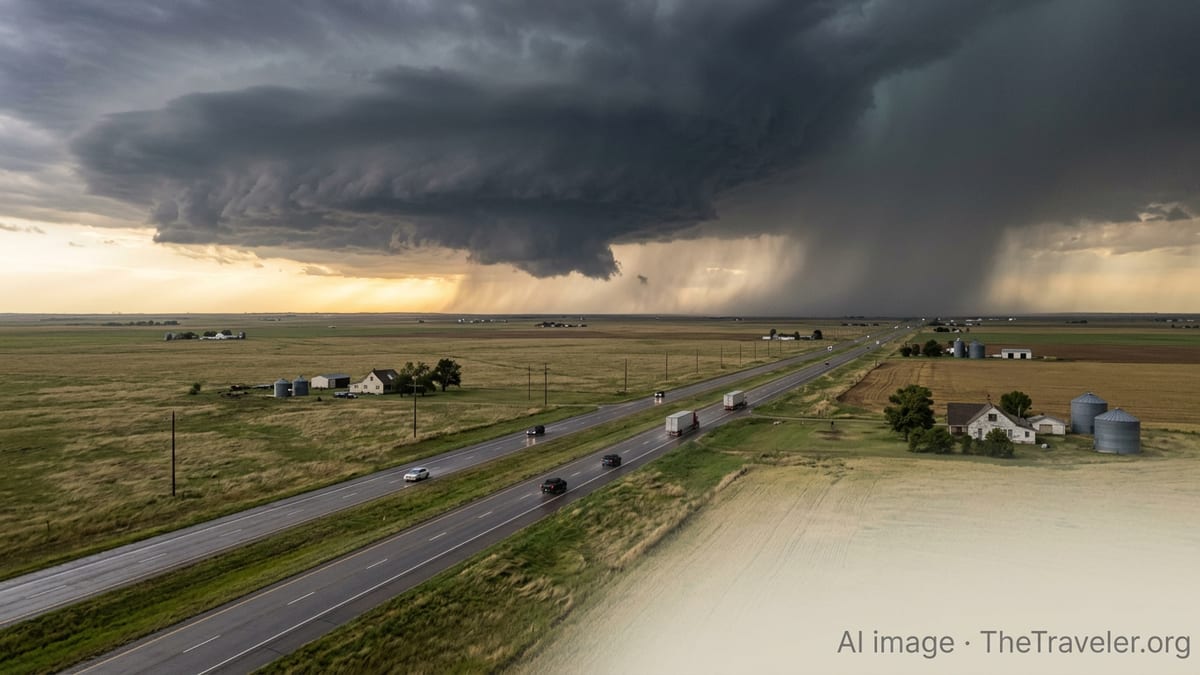
Scattered severe thunderstorms were already erupting late Thursday in the Texas Panhandle and western Oklahoma, setting the stage for a more organized and dangerous round of storms to develop Friday into Saturday as warmer, more humid air surges north from the Gulf of Mexico. Forecasters say this pattern will allow powerful supercell thunderstorms to form along a sharpening dryline and advancing cold front, a classic recipe for strong tornadoes and very large hail.
By Friday afternoon and evening, the highest risk is expected to focus from central and eastern Oklahoma and Kansas into western Missouri, with the threat corridor extending south into Texas and north toward Iowa and southern Wisconsin. Major metro areas including Dallas–Fort Worth, Kansas City, Tulsa, Omaha, Des Moines, St. Louis and Milwaukee are all watching forecasts closely for potential impacts to flights, highways and outdoor events.
For Texas, the looming outbreak follows a string of destructive severe weather episodes over the past several years, reinforcing the state’s reputation as both a storm-chasing hub and a high-risk destination for spring travelers. The prospect of multiple days of severe weather, including nighttime storms, has emergency managers urging both residents and visitors to refresh safety plans and pay attention to local alerts.
Destructive Winds and Giant Hail Threaten Travel and Infrastructure
While the headline risk is strong tornadoes, meteorologists stress that the broader threat from this system may come from damaging straight-line winds and very large hail capable of shattering vehicle windows and denting aircraft on the tarmac. Forecast guidance suggests wind gusts in the most intense storms could exceed 70 to 80 miles per hour, enough to topple trees, down power lines and cause localized structural damage over a wide area.
Travelers driving interstates that cut across the risk zone, including key corridors in Texas, Oklahoma, Kansas, Missouri, Iowa, Arkansas and Wisconsin, may encounter sudden whiteouts of wind-driven rain or hail, along with debris on roads. Authorities caution that the most dangerous storms may move quickly, leaving little time to react once warnings are issued. Truckers, in particular, are being advised to monitor forecasts closely as high-profile vehicles are especially vulnerable to overturning in severe crosswinds.
Air travel is also likely to feel the effects. Major hubs such as Dallas–Fort Worth and Kansas City could see ground stops, diversions and delays as thunderstorms roll through, especially during Friday afternoon and evening peak periods. Regional airports in smaller Midwestern and Plains cities may experience rapid changes in conditions as supercells develop and evolve into larger storm complexes.
In addition to immediate travel disruptions, the threat of power outages looms large. Strong winds and falling trees could leave pockets of Texas, Arkansas, Kansas and neighboring states in the dark just as temperatures spike well above seasonal norms. Hotels along interstate corridors may fill quickly with displaced residents and stranded motorists, adding another layer of complexity for weekend travelers.
A Shifting Tornado Alley and Earlier, Longer Seasons
The geography of this weekend’s threat highlights a broader trend that has caught the attention of both scientists and emergency planners. While the classic Tornado Alley historically centered on Texas, Oklahoma and Kansas, recent years have seen a rising share of tornado reports farther east and north into states such as Arkansas, Missouri, Iowa, Illinois, Kentucky and even parts of the Mid-Atlantic and Great Lakes regions.
Researchers point to a combination of factors, including subtle shifts in jet stream patterns, persistent moisture from the Gulf of Mexico and changes in land use, that may be influencing where the most volatile overlap of warm, moist air and strong wind shear occurs. The result: states like Arkansas, Missouri and Wisconsin are now more frequently finding themselves in the bull’s-eye during multi-day severe weather episodes that once might have been focused more narrowly on the southern Plains.
Another emerging signal is timing. Tornado season on the Plains traditionally peaks in May and early June, but the current outbreak is unfolding in early March, several weeks ahead of what many residents consider “normal.” In the Southeast and lower Mississippi Valley, peak season has also crept earlier, with significant tornado events increasingly occurring in late winter and early spring.
For travelers and tourism operators, that means the window for quiet, storm-free spring getaways has narrowed. Spring break trips to Texas hill country, Ozark campgrounds in Arkansas and Missouri, or city breaks in Dallas, Kansas City and Milwaukee now more frequently intersect with periods of heightened severe weather risk, making preparedness a central part of trip planning.
What Happens Next: Surprise Impacts for Travelers and Tourism
What may surprise many this weekend is not just the ferocity of the storms but how far-reaching the secondary impacts could be for travel and tourism across the region. Popular early spring festivals, rodeos, college sports events and outdoor markets from Texas to Iowa and Wisconsin face last-minute schedule changes or cancellations as organizers weigh safety against economic pressures.
For the growing community of storm tourists and photographers, the setup offers both opportunity and danger. Seasoned chasers are converging on the Plains to capture dramatic skies and rotating supercells, but emergency officials stress that inexperienced visitors attempting to follow storms can complicate evacuations and clog rural roads that first responders rely on. Local authorities in several states have reminded visitors that cell service and navigation apps can fail during intense weather, leaving drivers disoriented in unfamiliar countryside.
At the same time, communities that have invested in resilient infrastructure, clear signage to public shelters and robust alert systems could see an unexpected benefit. Successful emergency responses and minimized casualties during high-profile events often build confidence among travelers and can shape perceptions of safety in storm-prone destinations. Hotels that clearly communicate shelter locations, attractions that post real-time updates and tour operators who build weather contingencies into itineraries may emerge from this weekend with stronger reputations.
For those planning trips into or through the affected states, forecasters emphasize that preparation, not panic, is the right response. Checking local forecasts several times a day, enabling wireless emergency alerts, identifying sturdy shelter options in advance and allowing extra time for detours can significantly reduce risk while still allowing travel to continue for many.
How to Navigate an Unsettled Spring on the Road
As the central United States adjusts to a more volatile and extended storm season, travel experts say adapting habits is becoming essential. For road-trippers, that can start with something as simple as building flexibility into itineraries. Rather than locking in long drives during late afternoon and evening, when severe storms are most likely, some travelers are shifting to earlier departures and leaving room for extra overnight stops if conditions deteriorate.
Car rental companies and hotels in Texas, Oklahoma, Kansas, Arkansas and neighboring states increasingly encourage customers to share mobile contact information so they can send rapid updates about hail threats, parking guidance and shelter areas. Travelers who once focused primarily on wildfire smoke or winter snow as trip hazards are now weighing whether their accommodations have interior corridors, reinforced stairwells or designated safe rooms.
For air travelers, experts recommend scheduling flights earlier in the day, when the atmosphere is often more stable, and considering connections that route around, rather than directly through, the highest risk zones when possible. Packing a portable battery, essential medications and a small overnight kit in carry-on luggage can ease the strain if storms cause unplanned diversions or overnight delays.
In the long run, the expanding footprint of severe weather across Texas and the central and eastern United States may reshape how people think about peak travel seasons. As this weekend’s outbreak threatens to show, the states along and beyond Tornado Alley are learning to balance their appeal as vibrant, accessible destinations with the reality of a stormier, more unpredictable spring.