
Some Alaska itineraries race from one famous park to the next. Others linger in a single port or city. The most rewarding journeys, though, trace a middle path: a route that threads together active glaciers, reliable wildlife viewing, and the kind of small towns where you quickly recognize faces in the cafe. This balanced approach is possible on a loop that combines Southcentral Alaska’s road system with the coastal communities of the Inside Passage, creating a trip that feels both grand and surprisingly intimate.
Why This Route Works So Well
This Alaska route is built around three experiences that define the state for many visitors: standing in the cold shadow of a glacier, spotting wildlife in its own habitat, and spending unhurried time in small communities. Instead of choosing between a cruise and a road trip, you do a bit of both, linking the Anchorage and Kenai Peninsula region with a stretch of the Inside Passage by ferry and short flights. The result is an itinerary that feels varied without being frantic.
Anchorage serves as the main gateway for flights into Alaska and offers easy access to the Seward Highway, an All-American Road that follows Turnagain Arm toward the Kenai Peninsula with views of hanging glaciers and sharp peaks. From here, you can branch south to glacier-lined fjords around Seward and north again to the farming and river valleys of the Matanuska-Susitna region. Small-ship day cruises from ports like Seward and Whittier bring you close to tidewater glaciers and marine wildlife, while short drives reach compact towns with independent cafes, harbors, and hiking trails.
To balance out the road miles, the second half of this route focuses on Southeast Alaska. The Alaska Marine Highway System and regional airlines connect a network of small coastal communities in the Inside Passage, including Ketchikan, Wrangell, Petersburg, Sitka, Juneau, Haines, and Skagway. Many of these towns remain walkable and low-rise, anchored by fishing fleets, tribal culture, and forested backdrops. By shifting from highway to harbor, you trade road noise for boat wakes and the cry of gulls.
What ties these regions together is pace. Distances in Alaska look short on a map but feel long on the ground, especially when weather and tide dictate travel. This route builds in breathing room, encouraging you to stay two or three nights in each base rather than pushing onward each day. That slower rhythm increases your odds for clear glacier views, wildlife sightings, and the casual conversations with locals that often become a trip’s most enduring memories.
Anchorage to Seward: Glaciers at the Road’s Edge
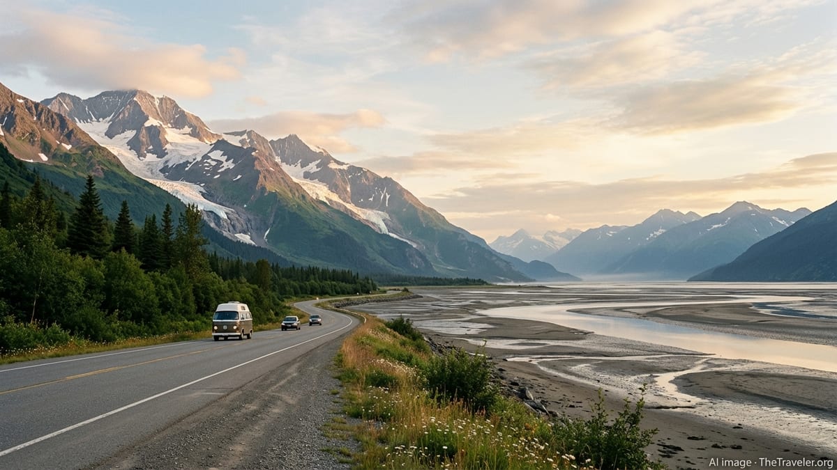
Anchorage is less a destination in itself than a soft landing and supply stop, bordered by mountains and tidal flats. Within minutes of leaving the city on the Seward Highway, urban scenery falls away. The road narrows to two lanes and begins to hug the shoreline of Turnagain Arm, framed by the Chugach Mountains and the distant Kenai peaks. This corridor is one of the most accessible stretches of wild scenery in the state, and it is common to spot beluga whales, Dall sheep, and bald eagles within a relatively short drive of town.
Short pullouts along Turnagain Arm provide views of powerful tides and, occasionally, a single wave of water known as a tidal bore rolling up the inlet. Across the highway, the slopes of Chugach State Park rise sharply, and with clear weather you see fingers of glacial ice clinging high above. The light here shifts constantly as clouds move over the peaks and the water reflects subtle shades of steel blue and brown. Give yourself far more time than the mileage suggests so you can linger at viewpoints rather than rushing all the way to Seward in one push.
For glacier-focused travelers, side trips are tempting. Near Portage Valley, the Begich, Boggs Visitor Center faces a lake fed by Portage Glacier, with icebergs often floating near shore. A short but dramatic one-lane tunnel leads to Whittier, a small port town surrounded by steep, glacier-hung mountains and a departure point for day cruises into Prince William Sound. These trips often travel into narrow fjords where tidewater glaciers, such as those descending from the expansive icefields in the region, calve ice into the sea and provide chances to see harbor seals resting on ice floes.
Continuing south, the highway climbs gently through mountain passes before dropping toward Resurrection Bay and the harbor town of Seward. Along the way, small communities like Moose Pass sit beside lakes and forested slopes, offering lodges, simple cafes, and trailheads that lead into the surrounding Chugach National Forest. By the time you reach Seward, you have already had a sampler of roadside glaciers, mountain scenery, and small-town Alaska, all before stepping on a boat.
Seward and Kenai Fjords: Icefields and Marine Wildlife
Seward feels like a frontier harbor set in an amphitheater of mountains. Fishing boats and tour vessels crowd the harbor, and on summer mornings the docks buzz with people geared up for either salmon and halibut trips or glacier and wildlife cruises into Kenai Fjords National Park. The town itself is compact and walkable, with a small downtown, a scenic waterfront path, and a mix of hotels, hostels, and independent lodges that can fill fast in July and August.
Kenai Fjords National Park protects much of the Harding Icefield and the tidewater glaciers that flow from it. The icefield spans hundreds of square miles and spawns dozens of glaciers, some of which reach the sea and terminate in steep, fractured ice faces. From Seward’s harbor, full-day and half-day cruises explore Resurrection Bay and extend into deeper fjords, where you may watch chunks of ice calve with a thunderous crack into the water. The park’s combination of rugged cliffs, seabird colonies, and ice makes it one of the most photogenic parts of coastal Alaska.
Wildlife is a central part of the experience. On a typical day cruise, passengers often scan for humpback whales, orcas, porpoises, and sea otters floating on the surface, as well as Steller sea lions hauled out on rocky ledges. Puffins, murres, and other seabirds nest along the cliffs, tracing swift arcs above the waves. Conditions on the open water can be choppy, so it is wise to plan your Kenai Fjords outing on a day when your schedule is flexible and to carry warm, windproof layers even in mid-summer.
Back on land, Exit Glacier provides one of the state’s most accessible hikes to the edge of an active glacier. A short drive from Seward brings you to a trail network where you can follow well-marked paths to viewpoints overlooking the ice and, for those prepared for a strenuous trek, along the famously demanding Harding Icefield Trail, which climbs above tree line to a panorama of flowing ice. Signs along the trail show former positions of the glacier in past decades, illustrating how quickly these landscapes change and underscoring the value of seeing them now.
Across Prince William Sound: Whittier and Coastal Fjords
To deepen the glacier and wildlife focus without repeating the same scenery, this route encourages a return drive up the Seward Highway with a side trip to Whittier. The single-lane Anton Anderson Memorial Tunnel, shared by cars and trains on a strict schedule, delivers you to a harbor town that still feels like a working port rather than a resort. Its mountain backdrop is particularly dramatic: dark slopes streaked with waterfalls and snowfields plunging straight into the sea.
From Whittier, small-ship cruises explore the intricate coastline and glacier-carved fjords of western Prince William Sound. This region is known for its dense concentration of tidewater and valley glaciers spilling from surrounding icefields. Inlets such as Blackstone Bay and College Fjord feature multiple active ice faces, hanging glaciers, and steep rock walls etched with waterfalls. The sea here is generally more sheltered than the Gulf of Alaska, which can make for calmer outings than some open-ocean routes.
Marine wildlife overlaps with what you may have seen near Seward, including sea otters, seals, humpback whales, and occasional orcas. What feels different is the intimacy of the landscape. The fjords in Prince William Sound are often narrow, with dense spruce and hemlock forests cloaking the lower slopes and mist curling around the peaks. On cool, overcast days, the atmosphere can feel almost monochrome, the only bright colors coming from glacial ice and the bright gear of passengers on deck.
Whittier itself offers a chance to experience a small Alaskan port up close. The town’s history as a former military outpost is still visible in its concrete buildings and compact layout, while its present-day life is tied to fishing, freight, and tourism. Even a short walk along the harbor reveals commercial fishing boats prepping for the season, local residents stopping for coffee, and visiting paddlers sorting gear before kayaking trips. An overnight stay here introduces a different pace from busier hubs and lets you experience the long twilight of summer evenings over the harbor.
North to the Mat-Su and Interior: Rivers, Valleys, and Open Space
After days of sea-level travel and fjords, it is refreshing to point the car north from Anchorage into the Matanuska-Susitna Valley, known locally as the Mat-Su. Unlike the narrow corridors of Turnagain Arm and Prince William Sound, this region opens into broad river valleys, farmland, and low, rounded hills. Communities such as Palmer and Wasilla serve as service centers for the surrounding area, but just outside town the landscape shifts to fields, wooded ridges, and views of the Chugach and Talkeetna Mountains.
Driving the Glenn Highway east from Palmer brings you into increasingly rugged terrain and spectacular views of the Matanuska Glacier, a long river of ice spilling down from the high peaks. Several roadside pullouts offer safe places to take in the panorama, and local operators provide guided walks and glacier hikes that step directly onto the ice. Even if you have already seen tidewater glaciers by boat, walking on or near a valley glacier gives a very different sense of scale, with blue crevasses, gravel-covered ice, and meltwater streams underfoot.
Continuing north on the Parks Highway, a detour to Talkeetna introduces one of Alaska’s most character-filled small towns. Often described as an artsy or bohemian community, Talkeetna’s compact main street holds historic buildings, independent cafes, and galleries that serve both locals and climbers heading toward the Alaska Range. Weather permitting, this is also a base for flightseeing tours around Denali and the surrounding glaciers. Even without taking to the air, walking the gravel roads down to the confluence of the Talkeetna, Chulitna, and Susitna rivers puts you face to face with wide, braided channels and expansive views.
Those with extra time and comfort on gravel roads can consider a partial journey along the Denali Highway, a remote, mostly unpaved route that runs between Paxson and Cantwell. Large segments of this highway remain lightly traveled and offer open vistas over tundra, kettle lakes, and distant peaks that hold glaciers in high cirques. Conditions can be rough, services are sparse, and portions close seasonally, so this side trip is best reserved for experienced drivers with a well-prepared vehicle. For many visitors, a short out-and-back section is enough to appreciate the sense of space.
Into the Inside Passage: Ferries, Floatplanes, and Forested Towns
Having sampled Southcentral’s road-accessible glaciers and valleys, this route shifts toward the coastal mosaic of Southeast Alaska, known as the Inside Passage. Here, steep forested islands, deep fjords, and narrow channels create a labyrinth that links dozens of small communities. Many of these towns are not connected by road to the rest of the state. Instead, residents and visitors rely on the Alaska Marine Highway System and a network of small-plane operators to move between ports.
The state ferry system, while subject to schedule shifts and budget constraints, remains a vital link between communities such as Ketchikan, Wrangell, Petersburg, Sitka, Juneau, Haines, and Skagway. Unlike large cruise ships, ferries carry local traffic along with independent travelers, backpackers, and road trippers continuing their journeys with vehicles on board. Traveling by ferry gives you time to watch for whales and dolphins from the open decks, see fishing boats heading to or from the grounds, and arrive directly into working harbors rather than dedicated cruise terminals.
Regional airlines operating wheeled planes and floatplanes supplement ferry service, especially for smaller communities that cannot support large vessels. From Juneau, for example, flights fan out to towns including Haines, Skagway, Gustavus, Hoonah, Kake, and Pelican, landing on short runways or sheltered coves. For travelers with limited time, pairing one or two ferry legs with short flights can preserve the sense of slow, water-based travel without committing days to a single long crossing.
The character of Inside Passage towns tends to be intimate and walkable. Many communities are anchored along a single waterfront street or a small grid of roads pressed between steep mountains and the sea. Once you step off the boat or plane, it is usually easy to reach docks, museums, local shops, and trailheads on foot. Lodging often consists of small hotels, family-run inns, and simple cabins, reinforcing the feeling that you are a guest in a place that exists first and foremost for the people who live and work there year-round.
Small-Town Stops: Ketchikan, Sitka, Juneau, Haines, and Skagway
To keep the itinerary balanced rather than rushed, this route recommends selecting three or four Inside Passage towns instead of trying to see them all. Ketchikan often serves as a southern entry point and introduces many of the region’s defining themes: dense coastal rainforest, salmon streams flowing right through town, and strong Native cultural traditions expressed through totem poles and clan houses. Elevated wooden walkways, historic buildings on pilings, and frequent rain give the town a distinctive atmosphere.
Farther north, Sitka sits on the outer coast, exposed to more open Pacific weather and swells. The town’s layered history spans Indigenous Tlingit roots, Russian colonial influence, and American governance, all of which are still visible in its architecture and cultural institutions. Wildlife excursions from Sitka’s harbor often encounter sea otters, humpback whales, and seabird colonies that thrive in the nutrient-rich waters where ocean currents meet. In town, forest trails and muskeg boardwalks place you quickly in quiet woods despite the modest size of the community.
Juneau, the state capital, feels larger and busier than most neighboring ports but still retains a compact and walkable downtown. Government buildings, shops, and small museums line steep streets that climb from the waterfront into residential neighborhoods. From an experiential standpoint, Juneau is notable for its proximity to Mendenhall Glacier, a valley glacier that you can view from roadside visitor facilities and approach on a network of trails. Short boat-based tours in nearby fjords provide additional glacier and wildlife opportunities, rounding out the coastal component of this route.
Haines and Skagway, connected to the road network via Canada as well as to Juneau by ferry and small planes, round out the small-town selection. Skagway’s historic main street is lined with restored Gold Rush era buildings and serves as a gateway to the mountains via the White Pass & Yukon Route railway and regional hiking trails. Haines feels quieter and more residential, with spread-out neighborhoods, strong ties to the Chilkat River valley, and noted opportunities to view bald eagles and brown bears in season. Both towns present a softer side of tourism, especially in the evenings when day visitors have departed and local life resumes its normal pace.
Balancing Seasons, Weather, and Wildlife Expectations
Alaska’s short visitor season and changeable weather shape how this route unfolds. Most travelers target late May through early September, when roads are clear, ferries and tours run consistent schedules, and days stretch long. Within that window, conditions vary. May and early June often see fewer crowds and more lingering snow on the peaks, while mid-summer brings the highest visitor numbers and a sense of bustle in popular ports and parks. By late August and September, fall colors creep into tundra and forest, and some wildlife movements, such as salmon runs and bear feeding, may become more concentrated.
Glacier viewing is possible throughout the summer, though clouds and fog can obscure high peaks and icefields. Coastal regions in particular receive substantial rain, so expectations should be flexible. Building in extra days in key glacier destinations like Seward, Whittier, and Juneau increases your odds of clear views and safe travel conditions on the water. In road-based segments, weather can also influence visibility, but the experience of driving through low clouds, with waterfalls appearing briefly through gaps, has its own appeal.
Wildlife encounters are never guaranteed, and responsible operators avoid promising specific sightings. That said, this route crosses habitats where certain animals are regularly observed in season. Marine mammals such as humpback whales, orcas, sea otters, and harbor seals frequent Kenai Fjords, Prince William Sound, and the Inside Passage. Bald eagles are a common sight along shorelines and rivers, and black and brown bears inhabit forest and salmon streams across much of the region. Smaller communities sometimes post informal notices about recent wildlife activity, and local guides remain a valuable resource for up-to-date information.
Planning with flexibility is essential. Ferry and flight schedules can change due to weather or operational needs, and road construction or minor rockfalls are not unusual in mountainous corridors. Travel insurance with trip interruption coverage may be worth considering, especially when connecting multiple segments. Most of all, a mindset that welcomes unscripted extra time in a small town cafe or along a rainy boardwalk will make it easier to embrace the unplanned turns that often define Alaska travel stories.
The Takeaway
This Alaska route reveals that you do not have to choose between glaciers, wildlife, and small-town character. By stitching together the Seward Highway and Kenai Fjords, coastal fjords around Prince William Sound, the open valleys of the Mat-Su and Interior, and a curated selection of Inside Passage communities, you experience a cross section of the state’s landscapes and cultures. The journey feels both expansive, thanks to the scale of the scenery, and personal, thanks to the time spent in walkable towns where daily life unfolds in full view.
What makes this itinerary especially satisfying is its balance of movement and stillness. Long daylight hours invite early starts and late returns, but the real value lies in slowing down: spending an extra night in a harbor town to watch weather shift over the mountains, lingering at a glacier overlook until the clouds lift, or saying yes to an impromptu conversation on a ferry deck. The trip is less about ticking off names of glaciers and more about assembling your own sequence of moments that connect ice, wildlife, and human communities into a coherent story.
In the end, the greatest reward of following this balanced route through Alaska may be a changed sense of scale. After days of watching icefields stretch to the horizon, whales surface beside your boat, and small towns cling to narrow strips of land between mountains and sea, familiar landscapes back home can feel temporarily smaller and quieter. That contrast is part of the appeal. This journey is not about dominating the wilderness but about glimpsing how people, animals, and glaciers coexist in a landscape defined by constant motion, slow change, and generous space.
FAQ
Q1. How many days do I need for this Alaska route that includes glaciers, wildlife, and small towns?
Most travelers should plan at least 12 to 16 days to combine Southcentral Alaska with a few Inside Passage towns, allowing two- or three-night stays in key bases.
Q2. What is the best time of year to travel this route?
The primary season runs from late May to early September, when roads are clear, most tours operate daily, and ferries and regional flights follow fuller schedules.
Q3. Do I need a rental car for the entire trip?
A rental car is very useful in Southcentral Alaska for the Seward Highway, Kenai Peninsula, and Mat-Su region, but in Inside Passage towns you can often rely on walking, taxis, and local shuttles.
Q4. How far in advance should I book glacier cruises and ferries?
In peak summer, it is wise to reserve popular glacier and wildlife cruises and Alaska Marine Highway ferry segments several months ahead, especially if traveling with a vehicle.
Q5. Will I definitely see whales and bears on this itinerary?
Sightings are never guaranteed, but this route passes through areas where humpback whales, orcas, sea otters, and both black and brown bears are commonly observed in season.
Q6. Is this route suitable for children and multigenerational groups?
Yes, provided you pace the itinerary conservatively, choose shorter boat trips where needed, and include downtime in towns so younger and older travelers can rest between excursions.
Q7. How expensive is this type of Alaska trip?
Costs vary widely, but visitors should be prepared for higher prices than many other destinations, particularly for lodging, vehicle rentals, and guided boat tours in peak months.
Q8. Can I do this itinerary without booking an organized tour?
Independent travel is very feasible if you are comfortable arranging rental cars, ferries, regional flights, and day trips yourself, and if you remain flexible around weather and schedule changes.
Q9. What kind of clothing and gear should I pack?
Layered, quick-drying clothing, a waterproof shell, warm hat and gloves, sturdy walking shoes, and a compact daypack are essential, along with binoculars and a protective case for cameras or phones.
Q10. How much walking or hiking is involved on this route?
You can keep walking to short, easy trails near town or choose longer hikes to glacier viewpoints and alpine terrain, tailoring daily activity levels to your group’s comfort and fitness.