
Lake Superior has a way of making you feel small in the best possible way. Sheer cliffs, ceaseless waves, and cold blue horizons combine into a landscape that feels more ocean than lake. Yet the same drama exists in other corners of North America, from Atlantic headlands to Pacific sea stacks and remote Arctic fjords. For travelers who crave that vast-water feeling and sculpted shorelines but want to try something new, these coastlines offer compelling alternatives to Lake Superior’s iconic scenery.
Cape Breton Highlands, Nova Scotia: Where Mountains Meet the Sea
On the northern tip of Nova Scotia, Cape Breton Highlands National Park is often described as the place where the mountains meet the sea. Steep headlands plunge to the Gulf of St. Lawrence on one side and the open Atlantic on the other, creating a rugged shoreline that feels like an oceanic cousin to Lake Superior’s most dramatic sections. Deep river canyons slice through a high plateau, while cliffs along the western shore rise sharply from the water, echoing the vertical drama that draws people to Superior’s North Shore.
The famed Cabot Trail, a 298 kilometer loop road, curls along the coast and over the highlands, offering constant views of ocean and escarpment. Pullouts above Pleasant Bay and Mackenzie Mountain provide sweeping panoramas of cliffs, coves, and endless water, especially striking at sunset when low light ignites the headlands. Hiking trails like the Skyline and Middle Head routes bring visitors right to the edge of the cliffs, where wooden boardwalks and open headlands look down on seabirds riding the wind and, in season, whales surfacing offshore.
Like Lake Superior, Cape Breton’s weather can change quickly. Fog, strong winds, and fast-moving fronts are all part of the experience, adding mood and atmosphere to the photographs you are likely to take. It is wise to pack layers and waterproof gear, even in high summer, and to plan extra time in your itinerary in case visibility drops or storms roll in. When skies clear, though, the combination of blue water, spruce-topped cliffs, and winding coast road rivals any freshwater vista in North America.
What sets Cape Breton apart is the blend of landscape and culture. Mi’kmaq, Acadian, and Scottish communities ring the island, and small fishing villages cling to the coastline between high headlands. After a day on the trails or scenic lookouts, you can walk a wharf lined with lobster boats, listen to traditional fiddle music in a community hall, or linger over seafood in a harborside restaurant. It is a reminder that dramatic coasts are not only about geology; they are also about the people who have learned to live with wind, waves, and long winters.
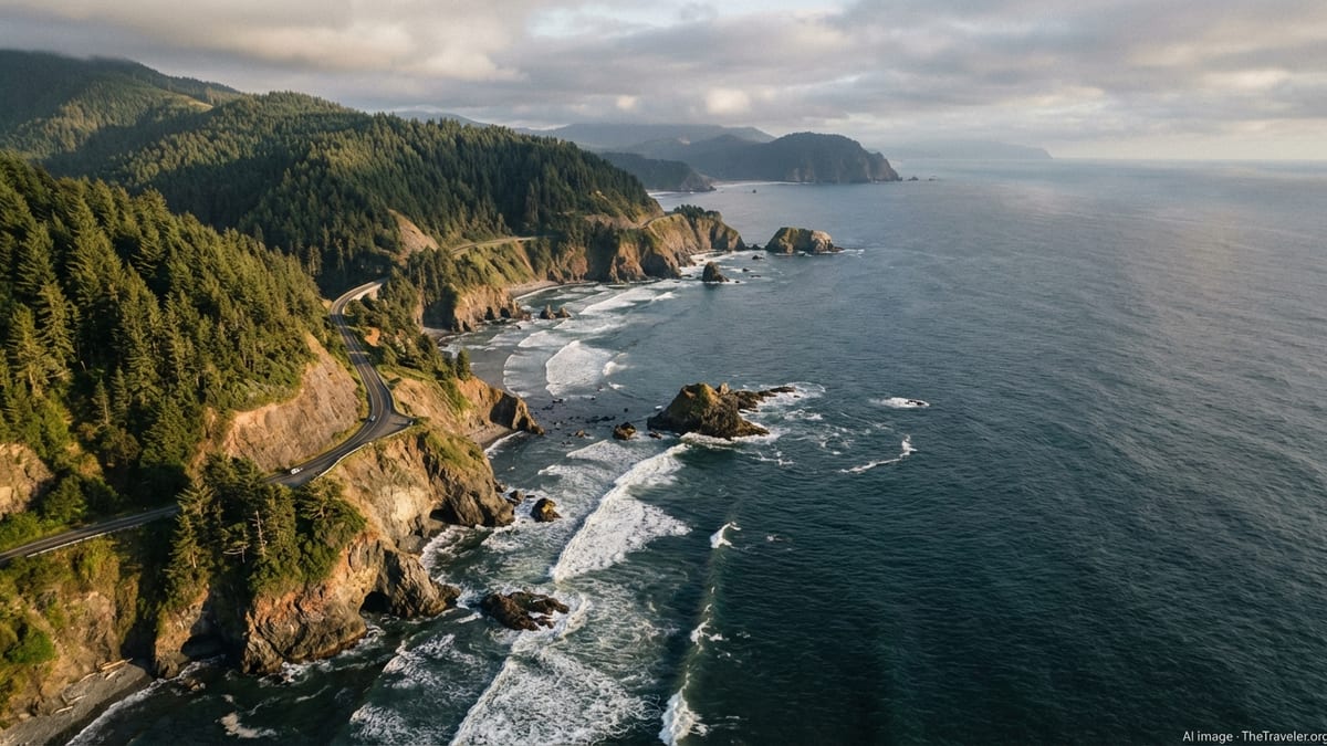
Big Sur, California: Cliffs Above the Endless Pacific
If Lake Superior sometimes feels like an inland ocean, Big Sur is its Pacific counterpart turned up several notches. Along a remote stretch of central California, the Santa Lucia Range rises almost straight from the sea, forming what geologists describe as one of the steepest coastal slopes in the contiguous United States. Ridges soar more than a thousand meters above the Pacific within a handful of kilometers of the shoreline, and the result is a coastline of plunging cliffs, isolated coves, and headlands that look purpose-built for dramatic road trips.
Highway 1 threads a precarious line between sea and mountains here, crossing concrete bridges that vault over wave-battered ravines. At roadside pullouts, you look down on surf-churned coves reminiscent of Lake Superior’s sandstone inlets, but with a different palette: turquoise water below, silvery fog bands offshore, and tawny hills above. In places the slopes are so abrupt that clouds scrape the ridges, leaving the water in sudden sunlight while the mountains vanish into mist, a kind of inverted version of Superior’s fast-moving squalls.
Big Sur’s trails add a more intimate perspective on the same drama. Footpaths climb through redwood canyons to exposed viewpoints where the entire highway and coastline unwind beneath you, and side tracks descend through chaparral to pocket beaches hemmed in by cliffs. The constant motion of Pacific swells churning against rock, combined with the cries of seabirds and the distant note of a foghorn, create an atmosphere that is more intense than peaceful. Like Lake Superior in a fall gale, this is a place that reminds you of the power of water.
Travelers used to the relative remoteness of Lake Superior’s North Shore will appreciate Big Sur’s sense of isolation despite its fame. Services are scarce between small settlements, cell coverage is patchy, and storm damage occasionally closes sections of road for weeks or longer. That remoteness is part of the appeal. It encourages slower travel, extra planning, and the kind of deep engagement with the landscape that Lake Superior loyalists know well.
Oregon’s Sea Stack Coast: Cannon Beach and Beyond
Where Lake Superior offers towering cliffs and broad horizons, the northern Oregon coast adds a sculptural element in the form of sea stacks: freestanding columns of volcanic rock that rise from the surf like stone ships. At Cannon Beach, the 70 meter high mass of Haystack Rock dominates the shoreline, a monolith accessible at low tide and ringed by foamy breakers the rest of the day. Smaller pinnacles, known locally as the Needles, flank the main stack and create a skyline that is instantly recognizable to anyone who follows seascape photography.
For travelers who love Superior’s rocky lakeshore but want an ocean setting, this stretch of coast feels familiar yet new. Long, flat beaches of hard-packed sand echo the walking possibilities around places like Minnesota’s Park Point, while the backdrop of forested headlands and basalt stacks adds the vertical punch. At low tide, tide pools at the base of the rock reveal starfish and anemones, introducing a marine dimension that a freshwater lake cannot match. Winter storms bring powerful waves and flying spray, a spectacle best enjoyed from a safe distance on the dune line.
Drive a short distance north or south and the coastline keeps reinventing itself. Short capes jut into the Pacific with grassy tops and vertical faces, reminiscent of Superior’s lava flow headlands but softened by a milder, wetter climate. Viewpoints such as Ecola and other state waysides reveal layers of coastal ridges fading into ocean haze, a compressed sense of distance similar to standing above Lake Superior on a clear day and watching the horizon curve away.
Persistent marine clouds keep the light soft and cool, making this coast particularly rewarding for photography. Even on overcast days, subtle shifts in brightness across sea, sand, and stone stacks create moody scenes. In late afternoon, if the sky breaks, the low sun often glances under the clouds, igniting the faces of the stacks and sending long reflections across the tide-washed sand. It is that combination of scale, movement, and shifting light that will feel instantly familiar to anyone who has fallen in love with Superior’s big-water moods.
Olympic Peninsula, Washington: Wild Beaches and Surf-Pounded Headlands
On the outer edge of Washington State, the Pacific coast of Olympic National Park offers one of North America’s rawest meeting points between land and sea. For travelers who appreciate Lake Superior’s wilder reaches, this is a coastline that feels kindred. A string of beaches, including Ruby, Rialto, and Second Beach, stretches along the park’s western margin, each framed by dense temperate rainforest and punctuated by clusters of sea stacks standing just offshore.
At Ruby Beach, boulders and drift logs litter the high-tide line, and dark sand gleams between tide pools at low tide. Offshore stacks, some topped with wind-sheared evergreens, take the place of Superior’s islands and outer reefs. Waves roll in with a steadiness that only the open Pacific can produce, their white crests breaking against rock in endless patterns of spray. In stormy weather, these beaches rival Superior’s fiercest days, though here the waves are larger and the tidal range adds another layer of dynamism to the scene.
What distinguishes the Olympic coast is the sense that the forest leans right into the surf. Massive spruces and cedars crowd the bluffs, and in places tree roots dangle over eroded banks, hanging in midair above the beach. Trails to the sand often wind through dripping understory, cross small creeks, and finally emerge onto a cobbled or sandy shore. The transition from deep shade to windswept openness can be abrupt, mirroring the feeling of emerging from Superior’s boreal woods to a lakeside cliff.
Despite its reputation, the Olympic coast still feels remote. Access roads lead in from Highway 101 to a handful of trailheads and campgrounds, but vast stretches of shore are reachable only by multi-day backpacking routes that cross headlands, navigate tide-dependent sections, and require careful planning. This combination of wildness, logistical challenge, and crashing surf makes it an appealing alternative for Lake Superior travelers who love backcountry adventures set against a backdrop of big water and sheer rock.
Atlantic Cliffs of Newfoundland: Fjord Walls and Wind-Lashed Headlands
For a taste of far-north drama that surpasses even Lake Superior in raw scale, turn to the coasts of Newfoundland. Along the island’s western and northern margins, glaciers carved deep fjords and left behind some of the highest sea cliffs in eastern North America. Places like Gros Morne National Park showcase inland fjord-like arms with nearly vertical walls, while the outer coast is lined with headlands and capes that drop sharply into the North Atlantic.
The mood here is austere and elemental. Wind can race unobstructed across the ocean, piling waves against rock ledges and sending spray high into the air. On clear days, the combination of blue water and rust-colored cliffs is striking, but many visitors come to appreciate the gray days even more. Fog curls around headlands, muffling sound and softening distance, in a way that recalls Lake Superior’s spring mornings. In early summer, towering icebergs sometimes drift past offshore communities, adding an Arctic note to vistas that are already dramatic.
Hiking trails along the coast range from short walks to demanding routes that climb high onto exposed plateaus. From these vantage points, you look down on sea stacks, sea caves, and narrow inlets where fishing stages and colorful houses cling to any available flat ground. The contrast between human-scale settlements and towering geology mirrors the experience of visiting small harbor towns along Superior’s North Shore, only here the ocean stretches on with no hint of another shore.
Newfoundland’s coastal roads, including famous routes like the Viking Trail and drive-to-the-edge spurs on the Avalon and Bonavista peninsulas, provide access to cliff-top lookouts and lighthouses that feel like the Atlantic’s answer to Superior’s dramatic points. Travelers should anticipate cool temperatures even in summer, along with rapidly changing conditions. The reward for that patience is a sense of space and solitude that rivals any freshwater coast, especially in shoulder seasons when visitor numbers drop and the only sounds are wind, waves, and seabirds.
Pacific Rim, British Columbia: Long Beaches and Storm Watching Shores
On the outer coast of Vancouver Island, Pacific Rim National Park Reserve offers a different flavor of coastal drama. Instead of high cliffs at every turn, you find long arcs of surf-washed sand backed by thick rainforest, broken by rocky points and offshore islands. It is a landscape built for watching waves. In winter especially, low-pressure systems march across the Pacific and send powerful swells crashing into the coastline, creating some of North America’s most celebrated storm-watching conditions.
For visitors used to Lake Superior, the Long Beach Unit of the park feels at once familiar and exotic. Broad, gently curving beaches resemble Superior’s more open stretches, while the constant roar of ocean surf and tang of salt air mark the difference. At low tide the wet sand mirrors the sky, and scattered rock outcrops, some bristling with coastal pines, rise from the intertidal zone like islands at low water. On calmer days, the horizon is a smooth line that evokes Superior’s inland sea; on wilder days, it becomes a ragged parade of whitecaps and spray.
Smaller pocket beaches and rocky headlands around Tofino and Ucluelet deliver steeper drama. Boardwalk trails wind through moss-draped forest to exposed platforms where you can safely watch storm waves explode against jagged basalt. In some coves, the combination of high tide and swell sends water surging through narrow chasms, throwing plumes of spray far above the cliffs. It is a reminder that, while Lake Superior is notorious for its storms, the full weight of the Pacific operates on a different scale.
The region’s maritime climate ensures that conditions are rarely static. Sun, cloud, fog, and showers can trade places within an hour, constantly reshaping the character of the coastline. This variability, paired with the juxtaposition of old-growth forest and restless sea, makes Pacific Rim an especially rewarding alternative for photographers and hikers who love Superior’s changeable moods and textured shorelines.
Lake Superior’s Spirit, Elsewhere: How to Choose Your Coast
What ties these far-flung shorelines together is not a single type of scenery but a set of shared qualities. They all offer the sense of immensity that makes Lake Superior feel like an inland ocean: big views, exposed headlands, and water stretching to a distant horizon. Each destination also has its own signature twist, whether it is the winding mountain roads of Cape Breton, Big Sur’s vertiginous highway cliffs, Cannon Beach’s sculptural sea stacks, the Olympic Peninsula’s log-strewn shores, Newfoundland’s ice-laced headlands, or Pacific Rim’s cinematic storm surf.
Choosing among them comes down to the kind of experience you want layered onto that core of big-water drama. If you are drawn to road trips where the journey is the attraction, Cape Breton’s Cabot Trail and California’s Highway 1 deliver days of windshield panoramas with frequent pullouts and short walks. For travelers who value on-foot immersion, the hiking networks in Cape Breton Highlands, the Olympic coast, Newfoundland’s national parks, and Pacific Rim invite multi-day explorations that bring you into intimate contact with cliffs, coves, and forested bluffs.
Season also matters. Many of these coasts are four-season destinations in theory, but access, weather, and services vary widely. Winter on the Pacific Northwest and Vancouver Island is prime time for storm watching, while late spring and early autumn on Cape Breton and in Newfoundland balance reasonable temperatures with fewer visitors. Summer brings longer days almost everywhere, but also more crowds on famous routes like Big Sur and the Cabot Trail. Travelers used to Lake Superior’s changeable conditions will recognize the value of building flexibility into plans and packing for a wider range of weather than the forecast suggests.
Perhaps the most important consideration, though, is how each of these places can change your sense of scale. Standing at a cliff edge in Cape Breton or on a rocky point in Pacific Rim, watching swells roll in from thousands of kilometers away, you realize that the feeling you chase on Lake Superior is not tied to one body of water. It is the humbling, exhilarating sense of being a small figure on the edge of something vast, whether that something is freshwater or salt sea.
The Takeaway
Lake Superior will always have a special pull for travelers who love wild shorelines and inland seas. Yet it is only one expression of a broader North American story in which cliffs, waves, forests, and sky collide in endlessly varied ways. From Atlantic Canada’s headlands to California’s vertical coast, from Oregon’s sea stacks to the storm fronts of the Pacific Northwest, each of these destinations offers a different way to experience the same essential feeling: that of standing on the threshold between solid ground and something immeasurably larger.
For some, that might mean tracing a sinuous road along mountain-backed coasts, pulling over whenever the water catches the light just right. For others it will involve wet boots on a remote trail, the sound of surf in the distance, and the thrill of reaching a viewpoint where land falls away at your feet. Whatever form your journey takes, seeking out alternatives to Lake Superior is less about replacing a favorite and more about deepening your appreciation of dramatic shorelines wherever they appear.
In the end, the world’s great coasts have more in common than they do differences. They are places of erosion and renewal, of constant motion and changing weather, where humans have always walked a narrow edge between respect and risk. Exploring them thoughtfully, with an eye to safety and a willingness to let plans bend to the elements, is one of the most rewarding ways to understand both the power of water and our own place beside it.
FAQ
Q1: Which destination most closely matches Lake Superior’s mix of cliffs and forested headlands?
Cape Breton Highlands in Nova Scotia is often the closest match, with spruce-covered plateaus ending in steep sea cliffs and a scenic loop road tying it all together.
Q2: Are these coastal destinations suitable for families with children?
Yes, but caution is essential near cliffs, surf, and tide pools. Many areas have short, well-marked trails and roadside lookouts that are family friendly when adults supervise carefully.
Q3: When is the best time of year to visit Big Sur for clear coastal views?
Late spring and autumn often provide a balance of clearer skies and fewer crowds, though coastal fog can appear in any season. Summer typically brings more persistent morning fog.
Q4: Do I need special skills to hike along the Olympic Peninsula’s beaches?
Basic hiking fitness is enough for popular day-use beaches, but multi-day coastal routes require tide planning, comfort on slippery surfaces, and familiarity with backcountry travel.
Q5: How do storm-watching seasons compare between Lake Superior and the Pacific coasts?
Both see powerful storms in late autumn and winter. The Pacific coasts of British Columbia and Washington typically have larger ocean swells, while Superior’s storms can bring intense wind and sudden squalls.
Q6: Are there budget-friendly ways to experience these dramatic coastlines?
Yes. Public campgrounds, off-season travel, and self-catered road trips help keep costs down. Many of the most memorable viewpoints are free roadside stops or short walks.
Q7: How dangerous are the cliffs and surf in these regions?
Dangers are real but manageable with care. Staying behind barriers, avoiding cliff edges, watching for unstable ground, and keeping clear of large surf and logs significantly reduce risk.
Q8: Can I see wildlife similar to what I might encounter around Lake Superior?
You will find different species, but a similar sense of wildness. Expect seabirds, marine mammals, and intertidal life, with occasional sightings of larger animals like whales or seals offshore.
Q9: Do these destinations require renting a car, or can I rely on public transportation?
Some limited public transit exists, but a car offers far more flexibility for reaching trailheads, viewpoints, and smaller communities along these dispersed coastlines.
Q10: How should I prepare for rapidly changing weather along these coasts?
Pack layers, waterproof outerwear, sturdy footwear, and dry bags for gear. Check local forecasts, but plan for conditions to shift quickly, much as they do around Lake Superior.