
More news on this day
A tornado watch remains in effect for parts of the Chicago area as strong spring storms rumble through the region, bringing torrential rain, damaging winds and the potential for large hail just as residents and visitors head into a busy early April weekend.
Get the latest news straight to your inbox!
Watches, warnings and a volatile spring setup
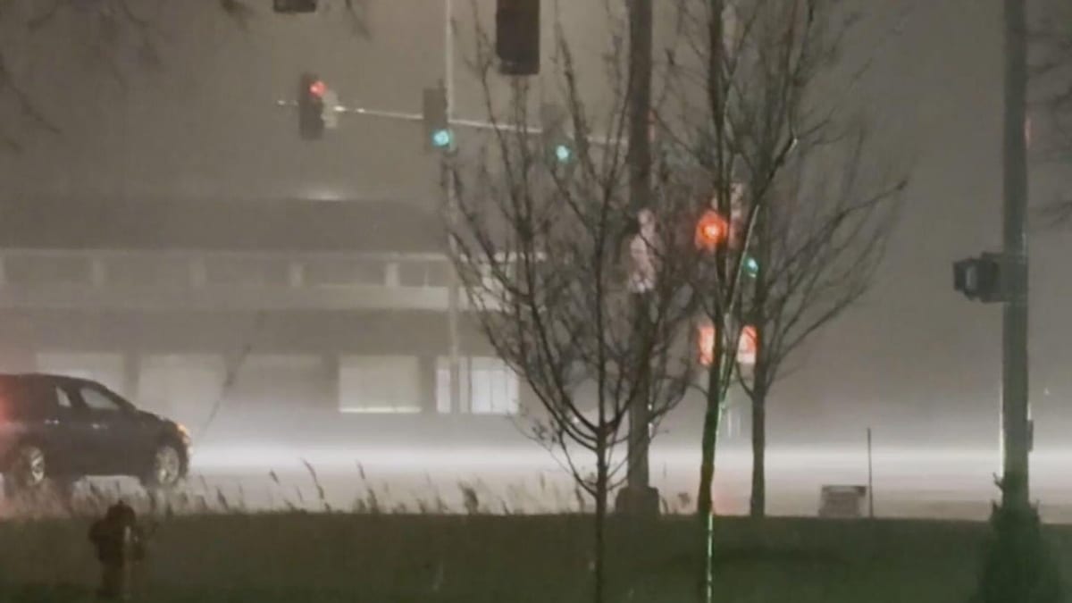
Publicly available information from regional weather coverage shows that a broad swath of northeastern Illinois, including many Chicago suburbs, is under a tornado watch as a powerful storm system moves across the Midwest. The watch highlights the risk of “intense” tornadoes in some locations, along with isolated wind gusts that could approach highway speeds and hail that may reach or exceed two inches in diameter.
Reports indicate that the storm environment over northern Illinois features unseasonably warm, humid air feeding into a fast-moving cold front, a classic pattern for severe weather in early spring. Forecasters note that wind shear and instability are strong enough to support rotating thunderstorms, some of which could briefly produce tornadoes as they track across the metro area and into northwest Indiana.
Coverage from local outlets describes several waves of storms sweeping through on Thursday and into Thursday night, with embedded supercell structures possible within larger lines of thunderstorms. Even areas that avoid tornadoes can still experience brief but intense downpours, frequent lightning and sudden bursts of damaging wind.
According to recent meteorological outlooks, the overall threat is categorized as an enhanced level of risk for severe thunderstorms over parts of the region, a mid-tier classification that still signals the potential for scattered significant events. The most volatile conditions are expected during the late afternoon and evening hours, when daytime heating peaks and wind fields strengthen aloft.
Travel disruptions on roads, rails and in the air
The severe weather arrives during one of the busiest travel periods of the day, raising concerns for those driving into and around Chicago or connecting through the city’s major transportation hubs. Published reports from local news and transportation advisories emphasize that heavy rain and ponding on roadways are already slowing traffic in some corridors, particularly along expressways and low-lying interchanges that are susceptible to quick flooding.
Wind gusts associated with the strongest storm cells are capable of downing tree limbs and blowing debris onto roads, creating additional hazards for motorists. Brief periods of near-zero visibility are also possible when stronger thunderstorms pass, making it difficult for drivers to see lane markings or brake lights ahead. Travelers are urged by widely available safety guidance to reduce speed, allow extra stopping distance and avoid driving through water-covered pavement.
Rail passengers may also encounter delays as commuter and intercity trains slow or temporarily halt service when lightning, strong winds or reports of track obstructions arise. Some coverage notes that earlier rounds of storms this week caused localized flooding near rail lines and station entrances, suggesting that additional rainfall could again impact certain routes during the evening commute.
At Chicago’s airports, the combination of lightning, low clouds and gusty crosswinds can trigger ground stops or slowdowns, particularly during peak arrival and departure banks. While specific delay figures shift by the minute, recent storm episodes have shown how rapidly thunderstorms can back up flights, causing missed connections and extended time on the tarmac for passengers transiting through the city.
Implications for visitors and outdoor plans
For visitors in Chicago for conferences, events or early spring getaways, the sudden onset of severe weather can dramatically alter plans. Outdoor architecture tours, river cruises and lakefront activities are particularly vulnerable to cancellations or schedule changes when lightning and high winds are in the forecast. Tourism operators often shift guests to indoor alternatives during active warnings, and some venues may close rooftop spaces or terraces for the evening.
Popular neighborhoods near the lakefront and along the Chicago River, typically bustling with evening foot traffic, are likely to see fewer pedestrians as storms pass through. Travelers staying in hotels in the Loop, River North or West Loop may hear weather sirens or mobile alerts during periods of heightened concern, signaling that conditions are favorable for tornado development in parts of the county.
Sports events, festivals and concerts scheduled for Thursday night face added uncertainty. Stadiums and open-air venues frequently pause entry lines, delay start times or ask attendees to shelter in place in concourses when lightning appears within a set distance. Visitors are encouraged by event organizers and widely distributed safety materials to monitor official channels and be prepared for last-minute changes.
Indoor attractions, including museums, theater performances and restaurants, will likely remain open but may see fluctuations in attendance as heavy rain bands move through. For many travelers, severe weather becomes part of the Chicago experience, prompting impromptu evenings spent watching the storms from hotel lobbies, high-rise lounges or train platforms rather than along the lakefront trail.
Storm history and growing severe-weather awareness
Chicago’s relationship with severe storms is long-standing, and the current tornado watch arrives against a backdrop of recent high-impact weather in the region. Historical summaries compiled by meteorological agencies and local media recount that the Chicago forecast area typically experiences several tornado watch days each year, as well as a larger number of severe thunderstorm watches tied to fast-moving spring and summer systems.
Recent years have included notable events, such as damaging hail and wind episodes in the suburbs, a widely discussed supercell over the city in 2022 and a series of strong tornadoes across portions of Illinois and Indiana in March 2026. These episodes have contributed to a heightened public awareness of how quickly conditions can escalate from routine rain to life-threatening storms across the metro area.
Local governments, emergency managers and transportation agencies regularly promote severe-weather preparedness campaigns each spring, encouraging residents and visitors alike to understand the difference between watches and warnings and to identify safe indoor locations before storms arrive. Public information from Illinois emergency preparedness materials stresses that a watch signals that tornadoes are possible in the broader area, while a warning indicates that a tornado is occurring or imminent in a smaller, more specific zone.
As the current round of storms evolves, that heightened awareness means more people are watching the sky, checking radar on mobile devices and paying close attention to broadcast or app-based alerts. For those new to the region, the experience can be both unsettling and instructive, revealing how a major Great Lakes city adapts in real time to rapidly changing weather.
Practical guidance for those on the move
For travelers already in transit across the Chicago area, practical steps can reduce exposure to the hazards associated with the ongoing storms. Widely shared safety recommendations advise that anyone driving during a severe thunderstorm should stay updated on conditions through radio or mobile alerts, seek sturdy indoor shelter if a tornado warning is issued nearby and avoid stopping under highway overpasses, which can become wind tunnels and debris traps.
Hotel guests and short-term renters are encouraged by emergency preparedness resources to locate interior hallways or designated shelter areas away from windows and exterior walls, especially on higher floors. Many properties provide basic guidance in-room or at the front desk about where to go during severe weather, and staff often monitor local coverage to decide when to direct guests to safer locations within the building.
Air travelers facing delays are generally advised by airline and airport information channels to stay near their gate, keep devices charged and maintain contact with carriers through apps or text alerts, since rebooking options can shift quickly when multiple flights are affected by storms. Those with flexible itineraries may find it useful to build additional buffer time into same-day connections through Chicago during active severe-weather patterns.
As the tornado watch and accompanying line of storms progress across the region, conditions will continue to change quickly from neighborhood to neighborhood. For visitors and residents alike, closely monitoring trusted weather coverage and remaining ready to adjust plans remains the most reliable strategy for navigating this unsettled spring day in Chicago.