
More news on this day
Travelers moving through the Chicago area on Thursday faced a volatile mix of tornado watches, high winds and flash flooding, with heavy rain snarling a key route to O’Hare International Airport as forecasters warned of a dangerous round of evening storms.
Get the latest news straight to your inbox!
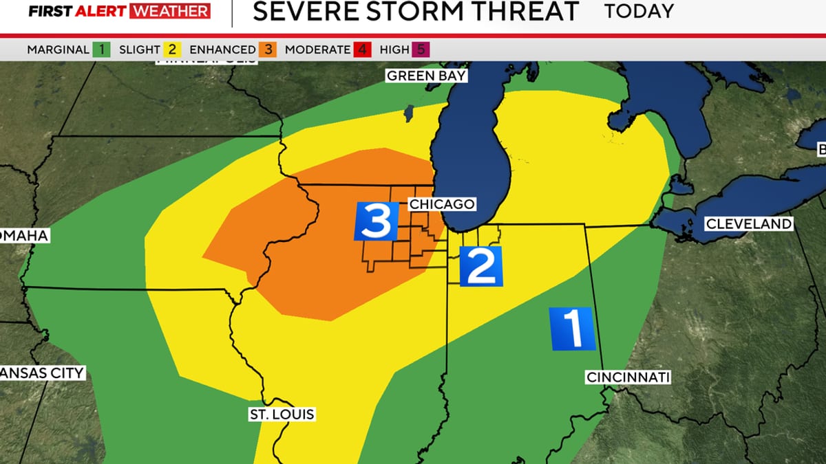
Image by CBS News
Severe weather threat intensifies across Chicago region
Publicly available forecasts from the National Weather Service and local outlets indicate that much of northern Illinois and northwest Indiana sits under an enhanced risk for severe thunderstorms on Thursday, April 2, 2026. Storms are expected to organize and strengthen through the afternoon and evening, with the potential for damaging winds, large hail and several tornadoes.
Reports describe a tornado watch in effect for portions of the wider region, overlapping with a wind advisory that covers the Chicago metro area. The severe threat is expected to peak late in the day, coinciding with the evening commute and the busiest hours for air travel into and out of Chicago’s airports.
Outlook discussions circulated by national storm centers note that atmospheric conditions over the Midwest are supportive of fast-moving supercell storms capable of producing strong, long-track tornadoes. Heavy rainfall rates within the storms also raise the risk of localized flash flooding on already saturated ground.
Travel-focused forecasting services are urging anyone flying through Chicago to monitor airline notifications closely on Thursday and to leave extra time for airport transfers, given the overlapping wind, tornado and flooding hazards.
Wind advisory brings airport disruptions and difficult flying conditions
A wind advisory in effect for the Chicago area through early evening warns of gusts that could reach 45 to 50 miles per hour, according to meteorological bulletins and regional news coverage. Such gusts, occurring both ahead of and within thunderstorms, can lead to turbulence aloft and challenging crosswinds during takeoff and landing.
Published updates from aviation tracking services and local broadcasters show that O’Hare International Airport has already experienced intermittent ground stops and delays as thunderstorms move across northeastern Illinois. Earlier in the day, a series of morning storms prompted temporary halts for some arrivals bound for Chicago as controllers worked to safely sequence traffic around lightning and low cloud ceilings.
Wind-driven rain has also reduced visibility at times, further complicating operations at one of the world’s busiest aviation hubs. Flight boards on Thursday reflected a growing number of delayed departures and arrivals, with ripple effects likely for connecting passengers traveling through Chicago to destinations nationwide and overseas.
For air travelers, the combination of a wind advisory and nearby severe storms often translates into slower operations on the ground, longer taxi times and the possibility of diversions to alternate airports if conditions deteriorate near peak storm hours.
Flooding constricts access roads near O’Hare International Airport
Heavy downpours trailing the first wave of storms created immediate problems for drivers approaching O’Hare. According to Chicago-area transportation reports, flooding reduced traffic on Interstate 190, the short spur that links the Kennedy Expressway to the airport terminals, after stormwater pooled near key ramps close to the airport complex.
Local coverage notes that earlier in the day, a flooded ramp from Mannheim Road toward I-190 was temporarily impassable, forcing crews to clear a clogged storm drain before reopening the connection. Separate reports describe lane reductions on I-190 itself because of standing water, with vehicles funneled into a single open lane at one point as the afternoon storms intensified.
These localized flooding issues contributed to backups on some of the primary routes that travelers use to reach O’Hare’s parking garages and terminal drop-off areas. Ride-share drivers and taxis faced additional delays as they navigated ponding water and slow-moving traffic near the airport perimeter.
Transportation agencies have urged motorists to avoid driving through flooded sections of roadway and to seek alternate routes if significant water remains on I-190 or surrounding surface streets. For departing passengers, the advice circulating across travel channels is to allow substantially more time than usual to reach the terminals.
Impact on travelers and guidance for those in transit
For visitors and residents alike, Thursday’s storms are creating a layered set of challenges across the Chicago region. Rail and bus commuters are dealing with strong crosswinds, heavy rain and the possibility of brief service disruptions, while drivers on area expressways are contending with hydroplaning risk and sudden visibility drops under the heaviest cells.
Travel industry briefings highlight the potential for knock-on effects to persist into Thursday night, even after the most intense storms pass, as airlines work through delays and reposition aircraft. Travelers connecting through Chicago late in the evening may still encounter schedule changes, particularly on routes that depend on aircraft arriving from storm-impacted areas of the Midwest.
For those already in the air en route to Chicago, inflight announcements have advised passengers to expect turbulence on final approach as aircraft descend through the windy, rain-soaked lower atmosphere. Once on the ground, passengers may experience longer waits for aircraft gates, baggage handling and ground transportation as airport operations adjust to weather-driven slowdowns.
Travel planners recommend that anyone scheduled to transit Chicago on Thursday review their itineraries frequently, monitor real-time flight status tools and stay alert to updated forecasts, especially during the late afternoon and evening window when the tornado and damaging wind threat is forecast to be highest.
What travelers should know for the hours ahead
Forecast discussions point to a volatile pattern continuing into Thursday night, with multiple rounds of storms possible and a continued chance for tornadoes and damaging winds in and around the Chicago metropolitan area. Additional showers and thunderstorms could follow into Friday, keeping soils saturated and prolonging localized flooding risks.
For those planning to reach O’Hare later in the day, travel advisories emphasize checking the status of access roads before departure, as further heavy downpours could once again inundate low-lying sections of I-190 and adjacent ramps. Publicly available information from local transportation agencies indicates that crews are actively clearing drains and monitoring underpasses to keep traffic flowing as conditions evolve.
Hotel operators near the airport and in downtown Chicago are monitoring the situation closely, with some travel platforms noting a rise in same-day bookings from passengers who choose to overnight rather than press on through severe weather. Travelers with flexible plans are being encouraged in some advisories to consider adjusting departure times to avoid the most active storm window.
With tornado watches, a wind advisory and fresh flooding all converging on a single travel corridor, the situation around O’Hare on Thursday underscores how quickly severe spring weather in the Midwest can disrupt even the most routine transit plans. For anyone flying into or out of Chicago, staying informed and building extra time into every leg of the journey will be essential until the storms finally move east of the region.