
More news on this day
Severe spring storms and late-season snow are disrupting travel across large parts of the United States this weekend, with new weather alerts for tornadoes, blizzard conditions and damaging winds affecting major highways and airline hubs.
Get the latest news straight to your inbox!
Storm Systems Target East, Midwest and Great Lakes
Publicly available forecasts indicate that a sprawling and fast-changing weather pattern is driving multiple hazards from the Plains to the East Coast between Sunday, March 15, and early next week. A broad area of thunderstorms is expected to sweep from the mid-South into the Mid-Atlantic, with the potential for strong wind gusts and tornadoes, while a separate swath of heavy snow and blowing snow continues to impact portions of the Upper Midwest and northern Great Lakes.
Coverage from national outlets describes a patchwork of impacts that already includes road closures in snowbound areas, power outages tied to high winds and flight disruptions at several large airports. In the Midwest, snow and strong gusts are making some secondary roads impassable and reducing visibility on key interstate corridors. Farther east and south, increasingly warm and humid air is setting the stage for severe thunderstorms capable of producing damaging straight-line winds as well as isolated tornadoes later Sunday into Monday.
Forecasters at the National Weather Service have highlighted an unusually broad risk zone for severe storms stretching from the Tennessee Valley to the Mid-Atlantic, including major population centers and several of the country’s busiest air travel hubs. At the same time, recent guidance points to a continuation of winter-like conditions across northern states, where additional snow and drifting could prolong difficult travel and slow recovery from earlier storms.
In the background, meteorologists note that this volatile setup follows a week of turbulent conditions that already brought destructive tornadoes to parts of the Plains and Midwest and a series of late-season winter storms to the Northeast and Great Lakes. For travelers, the result is a complex and evolving picture in which conditions can shift rapidly along a single route.
Airlines Post Weather Waivers as Delays Grow
Major US carriers have begun issuing weather-related travel waivers for parts of the Midwest, Northeast and island destinations affected by heavy rain and high winds, according to airline advisories and widely shared customer notices. These waivers generally allow passengers scheduled to travel on specified dates and routes to rebook once without change fees, although fare differences may still apply.
Reports from flight-tracking services show elevated delays and cancellations at hub airports where snow and wind are most intense, as well as in cities bracing for severe thunderstorms. Chicago, Detroit and Minneapolis have seen periodic slowdowns linked to low visibility, icy surfaces or crosswinds, while East Coast airports are preparing for potential ground stops if squall lines and embedded thunderstorms move directly over key approach paths.
Industry coverage suggests that airlines are increasingly proactive in consolidating flights and adjusting schedules ahead of major weather events in an effort to avoid widespread last-minute cancellations. Passengers, however, can still expect longer lines at customer service desks, tighter seat availability on alternative flights and crowding in terminals as operations are reset after each wave of storms or snow.
Travel analysts emphasize that policies differ by carrier and by event, so passengers are urged to review the specific waiver language for their airline and route. In many cases, rebooking must be completed within a defined window and return flights may need to fall within certain date ranges to qualify for fee-free changes.
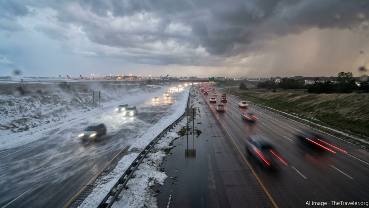
Highways Face Whiteouts, Black Ice and Severe Storms
For those traveling by car, the most immediate concern in northern states is heavy snow combined with strong winds, which can lead to near-whiteout conditions and drifts that quickly block smaller roads. State transportation agencies are reporting slick conditions on major interstates where snow is falling at a rapid rate and gusts are reducing visibility, even as plows work continuously.
In parts of the Upper Midwest and around the Great Lakes, published weather briefings highlight the risk of rapidly changing conditions where a wet, slushy snow can transition to ice as temperatures fluctuate. That can create patches of black ice on bridges, ramps and untreated local roads, catching drivers off guard after stretches of mostly wet pavement.
Farther south and east, the primary driving hazards are expected to shift toward intense thunderstorms, pockets of flash flooding and isolated tornadoes. According to storm outlooks shared by the Storm Prediction Center and regional forecast offices, a line of storms may race along key north-south and east-west corridors, producing sudden wind gusts that can push high-profile vehicles and scatter debris onto roadways.
Motorists planning long-distance trips through multiple regions may encounter both winter and severe-weather threats over the course of a single day. Travel experts recommend building in extra time, mapping out alternate routes in case of closures and being prepared to pause a trip if conditions deteriorate faster than forecast.
What Travelers Should Do Now
With hazards spanning such a wide area, the most consistent advice from emergency managers and transportation agencies is to monitor conditions close to departure time and remain flexible. Travelers are encouraged to check airline apps and airport status boards frequently, sign up for flight alerts and watch for updates from local forecast offices that cover both departure and arrival points.
For air travel, passenger advocates commonly suggest moving to earlier flights where possible, especially when storms are expected later in the day, and avoiding tight connections through cities highlighted for severe weather or heavy snow. Carry-on essentials such as medications, chargers, basic toiletries and a change of clothes can help if an unexpected overnight stay becomes necessary.
For road trips, trip-planning resources recommend keeping fuel tanks at least half full in wintry areas, packing warm clothing and blankets and carrying basic emergency supplies such as a scraper, small shovel and traction aids. In regions under severe thunderstorm or tornado risk, drivers are advised to identify sturdy shelters along the route and to avoid parking under highway overpasses, where winds can be amplified.
Travel insurance experts note that policies purchased before a storm is widely forecast may offer some protection if flights are canceled or a destination becomes temporarily inaccessible. However, coverage often does not extend to trips canceled solely because hazardous weather is possible, so travelers are urged to read the fine print of any policy before relying on it for flexibility.
Short-Term Outlook: More Weather Whiplash Ahead
Looking beyond the immediate alerts, meteorologists describe the current pattern as part of a broader sequence of extremes that have hit the United States in recent weeks. Publicly available analyses from federal forecast centers point to a combination of jet stream disturbances and contrasting air masses that favor sharp temperature swings, late-season snow and repeated rounds of severe thunderstorms.
Recent reporting has highlighted how some regions toggled from record warmth to accumulating snow in a matter of days, and how back-to-back systems have left little time for recovery between events. In the Northeast, communities impacted by a major blizzard in late February are now watching another round of strong winds and colder air, while parts of the Plains and Midwest contend with saturated soils and storm cleanup alongside new threats.
For travelers, that means the window for “settled” weather may remain narrow over the next week or more, particularly for routes that cross several climate zones. Aviation forecasters expect additional bouts of turbulence, low clouds and crosswinds, while highway officials warn that thaw-and-freeze cycles could continue to create potholes and new slick spots well into the early spring period.
Even so, transportation networks have shown the ability to recover quickly between systems when conditions improve. Airlines, airports and road agencies are relying on increasingly detailed short-term models to fine-tune staffing and operations, but the sheer variety of hazards this month underscores the need for travelers to stay informed, pack for changing conditions and be ready to adjust plans as new alerts are issued.