
Milwaukee is compact enough to feel approachable yet large enough that a little advance planning can make getting around far easier. Whether you are flying into the city, arriving by train, or driving in from elsewhere in the Midwest, understanding your transportation options will save time, money, and stress during your stay. From the lakefront to the Historic Third Ward and the vibrant neighborhoods beyond downtown, here is how to move around Milwaukee efficiently and comfortably.
Arriving in Milwaukee: Airport, Train and Bus Basics
Most air travelers arrive via Milwaukee Mitchell International Airport, located a short distance south of downtown. It is a relatively small and manageable airport by big-city standards, which helps keep walking distances and transfer times modest. Ground transportation options include rental cars housed in a consolidated facility, traditional taxis, ride-hailing services, shuttles, and local buses, along with a nearby Amtrak station that connects directly to Chicago and other Midwestern cities. For most visitors staying downtown, you can expect about a 15 to 20 minute drive between the airport and central hotels in normal traffic.
Mitchell Airport is well integrated into the regional rail network. The Milwaukee Airport Rail Station, set just west of the runways, serves Amtrak’s Hiawatha and Borealis services linking the airport area to downtown Milwaukee, Chicago and cities to the west. A free shuttle bus connects the airport terminal with the rail station, running frequently throughout the day so you can transfer with luggage in all seasons. Train travel can be especially attractive if you plan to avoid driving in downtown traffic or simply prefer to work, read or relax on the way in.
Many bus passengers and train travelers will instead arrive at Milwaukee Intermodal Station on the edge of downtown. This facility serves as the primary hub for Amtrak and a range of intercity bus carriers, placing you within walking distance or a quick transit ride of most major downtown hotels and attractions. From the Intermodal Station, you can continue your journey using city buses, The Hop streetcar, taxis, ride-hailing services, or bike-share, which makes it an efficient launch point if you are building an itinerary that relies on public transportation.
Because transportation patterns and fees can evolve, particularly for taxi and ride-hailing operations, it is wise to check estimated prices and travel times a day or two before you arrive. Around peak holiday weekends or major festivals, bookable services such as rail tickets and airport shuttles can fill quickly, so reserving earlier often yields better choices and smoother connections upon arrival.
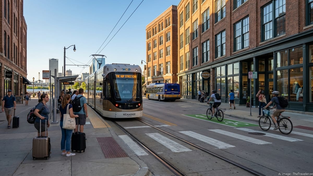
Navigating Downtown: The Hop Streetcar and Walkable Streets
Downtown Milwaukee is compact and pedestrian-friendly, so visitors can comfortably explore many of the core sights on foot. Sidewalks are generally wide and well maintained, and the lakeside breeze makes summer strolls particularly pleasant. The Historic Third Ward, the RiverWalk, and much of the central business district are close together, meaning you can often walk between dinner, a show, and your hotel without needing a car. Even in winter, locals commonly walk downtown, though you will want sturdy footwear and warm layers when sidewalks are snowy or icy.
To extend your reach beyond what is easily walkable, The Hop streetcar is one of the most convenient tools for visitors. The system links key destinations like the Intermodal Station, the Historic Third Ward, Cathedral Square and the Lower East Side. Service typically runs from early morning to late night, with vehicles arriving roughly every 15 to 20 minutes, so you rarely wait long. At present, rides are free, eliminating the need to navigate fare machines or passes. You simply wait at a marked platform, board when the streetcar arrives, and exit at your chosen stop.
The Hop is especially helpful if you prefer not to drive and park downtown. You can stay in a hotel near the route and rely on the streetcar to reach restaurants, bars, galleries and the lakefront. The vehicles and platforms are designed to be accessible, with level boarding that makes it easier for people using wheelchairs, strollers or rolling luggage to get on and off. Electronic signs and onboard announcements help you track the next stop, useful if you are new to the city.
Because the streetcar operates in mixed traffic in some segments, travel times can be affected by congestion, especially around large events or during construction. If you are on a fixed schedule for a museum reservation or performance, give yourself a cushion of extra minutes. In most cases, though, combining walking with The Hop will cover a large share of your downtown transportation needs without the hassle of driving or paying for short-term parking.
Using Milwaukee County Buses and On-Demand Transit
Beyond the downtown core, Milwaukee County Transit System, commonly referred to as MCTS, is the backbone of local public transportation. The bus network reaches into many neighborhoods and extends to nearby communities, including key corridors that connect the airport, university areas, and employment centers. Riders typically pay a modest fare per trip, with lower pricing for children, seniors, and riders with qualifying disabilities. You can pay with cash on board or use electronic payment options that cap your daily and weekly spending once you reach certain thresholds, which can be especially economical for longer stays.
For transit planning, digital tools are your best ally. MCTS offers an official trip planner and real-time bus tracker, and popular navigation apps often incorporate the same data. These tools allow you to enter your origin and destination, see route choices, and check when the next bus is due. If you are staying in Milwaukee for several days, it is worth familiarizing yourself with key lines that serve your hotel and the places you plan to visit, so you are not starting from scratch every time you head out.
In some parts of the region, an emerging option is microtransit or on-demand shuttles that complement fixed-route buses. One example is FlexRide Milwaukee, which focuses on connecting select city neighborhoods to suburban job centers and transit hubs. Riders book shared vehicles using a mobile app or phone service, then travel between defined zones for a set fare, sometimes with promotions that reduce or waive the cost when connecting to a transit hub or traveling at late-night hours. While FlexRide is geared toward commuters, savvy visitors staying near a participating zone may find it useful for reaching certain areas that are less convenient by regular bus.
Buses and on-demand services operate year-round, but schedules may change between weekday, Saturday and Sunday service, and adjustments are occasionally made to respond to rider demand or budget realities. Always confirm your timetable shortly before you travel, particularly if you have an early morning flight or a late event that pushes close to the end of service hours.
Airport to Downtown: Choosing the Right Transfer Option
Traveling between Milwaukee Mitchell International Airport and downtown is relatively straightforward, but choosing the right mode depends on your budget, schedule, and luggage. The simplest option for many visitors is a taxi or ride-hailing service such as Uber or Lyft. Vehicles pick up at clearly marked locations near baggage claim, and the ride into downtown typically takes under half an hour outside rush hour. Fares fluctuate with demand and may be higher during large events or peak travel periods, and airport surcharges are commonly built into the total, so always check the full estimated price before confirming your ride.
For more budget-conscious travelers, Milwaukee County buses provide direct airport-downtown connections. The GreenLine links the airport with downtown and neighborhoods to the north, while another key route serves downtown and nearby college campuses. Stops at the airport are located by the terminal exits, and buses are designed to accommodate airport passengers with luggage. Travel time to downtown can be somewhat longer than a car ride because of multiple intermediate stops, but fares are significantly lower, making this a good option if you are not in a hurry.
Rail can also be an efficient way to make the trip if your timing aligns with scheduled departures. The Milwaukee Airport Rail Station lies near the airport and is served by Amtrak routes that run between Milwaukee and Chicago, as well as beyond. After a short shuttle transfer from the terminal, you can board a train that arrives at Milwaukee Intermodal Station downtown, where you can switch to a streetcar, local bus, or simply walk to your hotel. Trains do not run continuously throughout the night, so advance timetable checks are important, especially for early-morning or late-night flights.
If you plan to rent a car at the airport, factor in costs for both the vehicle and parking at your hotel or in city garages. While driving gives you maximum flexibility for excursions around the region, downtown hotel parking can be a meaningful added expense, and you may not need a car at all if your plans focus mostly on central neighborhoods well served by transit and walking options.
Driving, Parking and Regional Day Trips
Visitors arriving by car often find Milwaukee easier to navigate than larger metropolitan areas, thanks to a simpler freeway network and manageable traffic volumes outside of peak rush hours. Major interstates funnel into the city from Chicago and Madison, while a grid of surface streets covers the central neighborhoods. Navigation apps typically perform well, and signage to key districts like the lakefront, downtown, and the university area is fairly straightforward. That said, construction projects can temporarily alter access ramps or lane configurations, so keep an eye on live traffic updates as you approach the city.
Parking is a central consideration for anyone driving. Many downtown hotels offer on-site or valet parking, but nightly rates can add up quickly, especially during festivals or major sporting events. Public garages and surface lots around the central business district, the Third Ward, and near the arena and stadiums provide alternatives that may be more affordable if you are willing to walk a few extra blocks. In residential neighborhoods, watch carefully for posted restrictions, snow emergency rules in winter, and time limits that can result in tickets or towing if overlooked.
For travelers interested in exploring beyond city limits, a car remains the most flexible option. Popular day trips might include visiting nearby lake communities, craft breweries and distilleries in surrounding towns, or hiking areas within easy driving distance. You can combine freeway segments with scenic country roads to get a broader sense of southeastern Wisconsin. If you prefer not to drive, intercity buses and Amtrak routes from Milwaukee Intermodal Station can carry you to Chicago, Madison connections, and other regional destinations, where you can rely on local transit or walking once you arrive.
During winter, road conditions can change rapidly due to lake effect snow and freezing temperatures. Rental cars are typically equipped for winter, but always drive conservatively, build extra time into your schedule, and stay alert for black ice on bridges and ramps. When a winter storm is forecast, consider whether you can adjust your plans or rely more on rail transit, which is sometimes less impacted by road closures.
Walking, Biking and Micromobility
One of Milwaukee’s strengths is that many attractions cluster close together along the lakefront and the Milwaukee River, making active transportation appealing for visitors. The city has invested in riverfront promenades and neighborhood streetscapes that encourage walking, and visitors often find that strolling between districts becomes part of the experience. In summer and early fall, the combination of warm temperatures and lake breezes makes walking between the Public Market, festival grounds, museums and downtown hotels particularly enjoyable.
For longer distances or simply to travel more quickly, bike-share can be a practical alternative. Docking stations are commonly found near major destinations, and you can unlock a bike using a kiosk or smartphone app, then ride it to another station near your destination. Milwaukee’s bike network includes riverside trails, lakefront paths and on-street bike lanes. You may share the path with joggers and families, so moderate speeds and courteous passing are appreciated, especially on weekends and during festivals when trails are busiest.
In recent years, many cities have experimented with shared scooters and other micromobility devices, and Milwaukee has participated in controlled pilot programs. Availability and rules can vary from season to season, and local regulations may require riding in certain areas while prohibiting devices on specific sidewalks or trails. If you see scooters in operation during your visit, take a moment to review in-app guidance on permitted zones, parking etiquette, and helmet recommendations so you can ride safely and avoid fines.
Regardless of how you choose to move around, urban cycling and walking in an unfamiliar city always call for situational awareness. Use marked crossings, follow traffic signals, make yourself visible at night with reflective clothing or bike lights, and avoid wearing headphones so loud that you cannot hear approaching vehicles or other trail users. These simple precautions help ensure that Milwaukee’s walkable streets and trail system remain a highlight of your trip, rather than a source of stress.
Seasonal and Accessibility Considerations
Milwaukee’s transportation experience can vary dramatically by season, and planning ahead will help you adapt. Summer brings festivals, outdoor concerts and baseball games that draw large crowds to the lakefront and stadium areas. Public transit and rideshare demand can spike at the same time, occasionally leading to longer waits and surge pricing. If you are attending a major event, consider whether you can walk or use The Hop or buses to avoid traffic bottlenecks, or travel earlier in the day before the heaviest flows develop.
Winter, by contrast, presents its own set of challenges. Snow, slush and cold temperatures can slow movement by foot, bike or car. Sidewalks are generally cleared, but some may remain slick, so footwear with good traction is important. Transit agencies continue operating in most weather conditions, but extreme storms can cause delays or schedule modifications, so check alerts before heading out. If you expect to be outside for more than a few minutes waiting for a bus or train, dress in layers, protect your face and hands, and consider using indoor spaces like station concourses or hotel lobbies as staging points while you track real-time arrivals.
Accessibility is a central focus in much of Milwaukee’s transportation network. City buses are equipped with ramps or lifts and have priority seating for riders with mobility challenges. The Hop streetcar has level boarding platforms designed for wheelchairs, strollers and rolling luggage, along with audible and visual stop announcements. Major hubs like Milwaukee Intermodal Station and the airport rail station provide elevators or ramps and accessible restrooms, and many downtown crosswalks are outfitted with curb cuts and tactile paving. While conditions can still be more demanding during winter weather, the underlying infrastructure aims to accommodate a wide range of travelers.
Travelers with specific accessibility needs should consider calling transport providers in advance to confirm details such as lift availability, paratransit eligibility, or the best boarding locations at stations. If you rely on paratransit-style services, Milwaukee County offers dedicated programs that may require prior registration and trip booking windows, so factor that lead time into your planning well before your travel dates.
The Takeaway
Milwaukee offers a flexible mix of transportation options that collectively make the city approachable for first-time visitors and repeat travelers alike. A walkable downtown core, a free streetcar, and a countywide bus network form the backbone of urban mobility, while taxis, ride-hailing services and rental cars provide additional convenience for airport transfers and regional excursions. Bike-share and walkable corridors along the river and lakefront add a pleasant, low-cost dimension to getting around when the weather cooperates.
To make the most of your visit, begin by clarifying how comfortable you are with public transit and how far your plans extend beyond downtown. Visitors focused on central attractions may be able to rely primarily on walking, The Hop and occasional short rides, while those exploring farther afield might benefit from renting a car or learning a few key bus routes. No matter which mode you choose, checking real-time information and seasonal conditions shortly before each outing will help you avoid surprises.
By thinking through your arrival, your day-to-day transportation, and your departure well in advance, you can spend less time puzzling over maps or waiting on a curb and more time enjoying Milwaukee’s lakefront, neighborhoods, dining scene and cultural attractions.
FAQ
Q1. Is it necessary to rent a car when visiting Milwaukee?
It depends on your plans. If you are staying downtown and focusing on central attractions, you can often rely on walking, The Hop streetcar, and buses. For regional day trips or more distant suburbs, a car becomes more useful.
Q2. How long does it usually take to get from Milwaukee Mitchell International Airport to downtown?
Under typical traffic, the drive takes around 15 to 20 minutes by taxi, rideshare or car. Buses and rail connections may take a bit longer because of intermediate stops and transfer time.
Q3. Is The Hop streetcar really free to ride?
As of early 2026, The Hop streetcar does not charge a fare, so you can board and exit without tickets or passes. Riders should always check for any policy changes before traveling.
Q4. Are buses and streetcars in Milwaukee accessible for travelers with mobility challenges?
Yes, Milwaukee County buses and The Hop streetcar are designed with accessibility in mind, including ramps or level boarding, priority seating, and audible and visual stop announcements.
Q5. What is the most budget-friendly way to get from the airport to downtown Milwaukee?
Local bus routes that serve the airport are usually the lowest-cost choice, with fares significantly cheaper than taxis or rideshares. They require more time but can be ideal for budget-conscious travelers.
Q6. Is it safe to walk around downtown Milwaukee at night?
Many visitors walk downtown in the evening, especially around well-lit areas near hotels, restaurants and venues. As with any city, staying aware of your surroundings and sticking to busy streets is advisable.
Q7. Can I use bike-share to get to the lakefront and riverwalk areas?
Yes, bike-share stations are commonly located near the lakefront, riverwalk and central neighborhoods, allowing you to pick up a bike, ride along trails or streets, and dock it near your next stop.
Q8. How does winter weather affect transportation in Milwaukee?
Snow and cold can slow driving, walking and biking, and occasionally disrupt transit. Agencies generally keep operating, but you should allow extra time, wear warm clothing, and check for service alerts during storms.
Q9. Is it easy to make a day trip to Chicago from Milwaukee without a car?
Yes, frequent Amtrak trains and intercity buses link Milwaukee and Chicago. Services depart from Milwaukee Intermodal Station, making car-free day trips quite feasible if schedules match your plans.
Q10. What is the best way to pay for public transit if I am only in town for a few days?
Short-term visitors often combine cash fares with mobile payment options or transit cards that support fare capping. This approach keeps things simple while preventing you from overpaying if you ride frequently during your stay.