
More news on this day
A slow moving Kona low winter storm has drenched parts of Hawaii with record and near record rainfall this week, triggering widespread flooding, road closures and transport delays that are disrupting travel across Oahu, Maui and other islands at the peak of the late winter visitor season.
Get the latest news straight to your inbox!
Record Rainfall and Worst Flooding in Two Decades
Publicly available information from the National Weather Service and recent news coverage indicate that the current storm system has produced Hawaii’s most severe flooding in roughly 20 years, with days of intense downpours falling on ground already saturated by earlier March rains. A Kona low pattern, which draws deep tropical moisture over the islands, set up in mid March and has repeatedly funneled heavy rain bands over the same areas.
On Oahu’s North Shore, gauges recorded daily rainfall totals that local observers describe as among the highest ever documented for the month of March, with some stations reporting well over a foot of rain in 24 hours and multi day accumulations far beyond seasonal norms. Social media posts and community reports reference rainfall amounts that residents are comparing to the notorious “40 days and 40 nights” event of 2006, when prolonged storms drenched the islands and triggered a series of damaging floods and landslides.
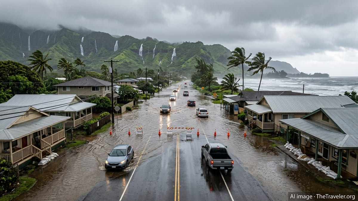
The latest storm intensified heading into the weekend of March 21 and 22, 2026, bringing muddy floodwaters that swept through coastal and inland neighborhoods, damaged homes and vehicles, and left thick deposits of silt and debris on streets and properties. Hydrologists note that record or near record rainfall in short periods greatly increases runoff, overwhelming small streams and drainage systems that are not designed for such extremes, especially in low lying resort districts and valley communities.
Forecasters caution that although the heaviest bands have begun to shift eastward and weaken, additional showers remain in the forecast, and any new bursts of intense rain could rapidly renew flash flooding in areas where soils remain saturated and waterways are already swollen.
Road Closures Sever Key Visitor Corridors
The most immediate impacts for travelers have been on the road network, where flooding, washouts and debris have forced closures on several key routes popular with visitors. On Oahu, reports indicate that stretches of highways and local roads north of Wahiawa and Kualoa have suffered extensive flood damage, prompting officials to keep access tightly restricted while crews assess undermined pavement, eroded shoulders and damaged bridges.
Community advisories circulating among visitors emphasize that driving into heavily affected North Shore zones purely for sightseeing is strongly discouraged, both for safety reasons and to avoid hampering recovery efforts. Residents are urging tourists in Honolulu and Waikiki who had planned day trips to iconic surf towns and coastal parks to postpone those excursions until conditions stabilize and updated guidance on road safety becomes available.
On Maui, accounts from visitor forums describe localized landslides, standing water and thick mud on segments of rural roads, including popular scenic drives. Some travelers reported detours, intermittent lane closures and long waits as work crews cleared fallen trees and rockfall. Low lying sections near streams and gulches have been particularly vulnerable, with temporary barriers and barricades going up where erosion has eaten away at the roadway edge.
State and county transportation updates highlight that conditions can change rapidly from passable to hazardous, especially overnight and during peak rain periods. Rental car users are being urged, through travel advisories and visitor information channels, to check real time updates, avoid attempting to cross flooded roads and to build extra travel time into any inter island driving itineraries.
Flight Delays, Diversions and Inter Island Disruptions
While Hawaii’s major airports have remained operational, the combination of torrential rain, low cloud ceilings and gusty winds has led to periodic flight delays and schedule changes. Airline status boards for Honolulu and Kahului showed clusters of late departures and arrivals during the worst of the downpours, reflecting the need for extended ground handling times and occasional temporary pauses in operations as thunderstorms moved directly over runways.
Inter island travel has also been affected. Regional carriers operating short hops between Oahu, Maui, Kauai and Hawaii Island reported a series of weather related delays and, in some cases, cancellations or diversions when visibility fell below safe thresholds or when crosswinds exceeded operational limits for smaller aircraft. Travel platforms and airline notices advise passengers to monitor their flight status closely, allow longer connection times, and be prepared for last minute gate or timing changes as additional rain bands move through.
Harbor operations have experienced intermittent disruptions as well, particularly for small passenger vessels, snorkel and whale watching tours, and inter island ferries where sea conditions have become rough and near shore waters are choked with runoff. Brown water advisories remain a factor in several coastal areas, reflecting the presence of sediment laden floodwaters entering bays and reefs. Tour operators have adjusted schedules, rerouted trips or temporarily suspended excursions in response to high surf, poor visibility and water quality concerns.
Travel industry analysts note that while Hawaii’s aviation system is resilient and accustomed to tropical weather, the persistence and intensity of this month’s rains have created a more prolonged period of disruption than is typical, especially for visitors trying to coordinate multi island itineraries or tight turnarounds between flights and cruise or tour departures.
Impact on Hotels, Attractions and Visitor Plans
The tourism sector, which plays a central role in Hawaii’s economy, has been scrambling to adjust. Hotels and vacation rentals in affected areas have reported localized power outages, minor flooding in ground floor units and temporary closures of pools, beach access points and outdoor amenities due to heavy rain, strong currents and debris. In some North Shore and rural communities, properties have shifted guests to higher floors or alternate buildings while cleanup continues.
Major attractions and tour operators are also revising schedules. Popular hiking trails, waterfall viewpoints and coastal parks have seen closures due to landslide risk, washed out footbridges and unstable cliffs, with agencies warning that saturated slopes may remain hazardous even after skies clear. Visitor guidance notes that trails that seem only mildly muddy can conceal undercut sections and sudden drop offs, especially along ridge lines and stream banks.
Travel forums and visitor information hubs are filled with accounts of travelers reworking plans on short notice, swapping beach days and road trips for indoor cultural activities, museum visits and urban dining in Honolulu and other town centers. Some travelers describe extending stays on one island rather than risking inter island transfers during the most active storm periods, while others are shortening visits to hard hit areas and booking last minute accommodations in less affected regions.
Industry observers say flexible booking policies, which have become more common since the pandemic, are helping many visitors shift dates, change islands or adjust excursions without heavy penalties. However, those who booked nonrefundable options or tightly packed itineraries have found it more difficult to absorb the disruptions, particularly when multiple flights, car rentals and tours are interconnected.
Advice for Current and Upcoming Visitors
For travelers already in Hawaii, local emergency management offices and visitor bureaus are urging close attention to forecasts, watches and warnings as the storm system gradually weakens. Publicly available guidance emphasizes staying away from swollen streams, river mouths and flooded lowlands, as flash flooding can occur with little notice when heavy rain falls upstream, even if conditions appear to be improving near the coast.
Beachgoers are being reminded to heed posted signs and to be cautious of brown or murky water, which can indicate runoff carrying debris and reduced visibility for swimmers and surfers. Lifeguard advisories highlight that strong currents and shifting sandbars are common after major rainfall events, altering familiar beach profiles and increasing the risk of rip currents, particularly along exposed shorelines on the North Shore of Oahu and windward coasts of other islands.
Travel planners recommend that visitors arriving over the next week build in greater flexibility than usual, avoiding tightly stacked activities on travel days and prioritizing refundable options where possible. Checking airline apps, hotel and rental car messages, and official county or state alert systems before setting out for the airport or embarking on long drives is being framed as an essential part of trip planning during this event.
Climate specialists point out that while intense Kona low systems have long been part of Hawaii’s winter weather pattern, a growing body of research associates a warmer atmosphere with the potential for heavier downpours when such systems do form. For travelers, that trend may translate into more frequent episodes of high impact rain and short notice disruptions, underscoring the importance of travel insurance, flexible bookings and a willingness to adjust plans in response to rapidly evolving local conditions.