
More news on this day
After the warmest days of the year so far across parts of the United Kingdom, forecasts now point to a sharp plunge in temperatures, with snow and wintry showers expected in Scotland and some northern areas just as early-spring tourism begins to pick up.
Get the latest news straight to your inbox!
From Springlike Temperatures to Arctic Air
The UK has just emerged from an unusually mild spell for March, with temperatures widely climbing into the mid to high teens Celsius and some locations recording the warmest day of the year so far. Publicly available data from national forecasters and broadcast outlets indicates that this warmth was several degrees above seasonal averages, encouraging many residents and visitors to treat the past week as an early start to spring.
This pattern is now reversing as a mass of colder Arctic air moves south across the country. Weather outlooks published over the weekend of 21–22 March 2026 describe a “cold plunge” that will drag temperatures back into single figures for many areas, feeling lower in strong winds. The contrast between the recent almost-summerlike afternoons and the incoming air will be particularly noticeable for travellers who have packed for mild conditions.
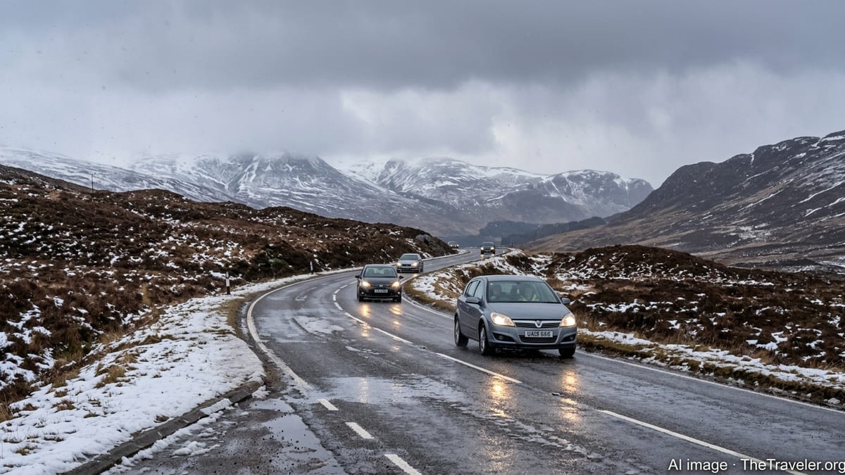
Forecast charts suggest that the coldest air will focus on Scotland, Northern Ireland and parts of northern England, especially from higher ground northwards. While southern England is expected to see a drop in temperatures and periods of rain, the more wintry side of the system is projected for the northern half of the UK where air remains sufficiently cold for snow, at least over hills and mountains.
Forecasters also note that this type of flip from warmth to wintry weather is not unusual in March, when the strengthening sun contrasts with lingering cold over the North Atlantic. For visitors, however, the speed of the change can be surprising, particularly for those arriving from milder parts of Europe or North America.
Snow Risk Focused on Scotland and Higher Ground
According to recent forecast discussions from UK weather services and major broadcasters, the most significant snow risk in this cold snap is centred on Scotland, especially the Highlands, Grampians and upland areas in the north and west. Guidance points to bands of showers turning wintry as colder air deepens, with accumulations most likely above about 300 to 400 metres.
Some outlooks mention the potential for several centimetres of snow on higher routes, with drifting in stronger gusts over exposed passes. Lower-level communities in northern Scotland may see sleet or temporary wet snow, particularly overnight and in heavier showers. Elsewhere in northern England and parts of Northern Ireland, wintry showers are possible on high ground such as the Pennines and upland stretches of the Lake District.
At the same time, the lowest-level urban centres, including cities such as Glasgow and Edinburgh, are more likely to experience a mix of rain, sleet and brief wet snow that may not settle for long. Road surfaces in larger towns are expected to remain mostly just wet, although icy patches could form overnight where skies clear and temperatures dip close to or below freezing.
The overall picture is of a short but sharp return to late-winter conditions rather than a prolonged severe spell. Nonetheless, travellers planning to drive through upland areas of Scotland or northern England, or to explore more remote landscapes, should be prepared for quickly changing conditions within relatively short distances.
Travel and Transport: What Visitors Should Expect
Publicly available travel and weather briefings indicate that the combination of colder air, hill snow and strong winds could lead to some localised disruption, especially in northern and western Scotland. Short-term impacts may include reduced visibility in snow showers, tricky conditions on exposed roads and the possibility of temporary restrictions on high-sided vehicles on certain bridges and routes.
Rail operators serving northern routes sometimes adjust timetables or operate at reduced speeds in poor weather, and mountain routes can be particularly vulnerable to delays. While widespread shutdowns are not currently forecast, visitors should allow extra time for journeys and check service updates on the day of travel, particularly for rural lines and cross-border services between England and Scotland.
Airports in Scotland and northern England are generally well equipped to handle late-season wintry weather, but heavier snow showers can still cause short-notice schedule changes. Standard aviation guidance suggests that de-icing procedures and runway condition checks may lead to minor delays during more intense bursts of snow or sleet.
For those using buses and long-distance coaches, routes across higher ground are the most likely to be affected by any temporary road closures or diversions. Travellers are advised by transport operators and tourism bodies to keep itineraries flexible, avoid very tight connections, and monitor local traffic bulletins when planning day trips into rural or mountainous areas.
Packing and Safety Advice for Tourists
Tourism boards and outdoor organisations emphasize that visitors should prepare for a wider range of conditions than recent warmth might suggest. Layered clothing is important, including a windproof and waterproof outer layer, warm mid-layers and a hat and gloves for time spent outdoors in Scotland, northern England and high coastal viewpoints.
Footwear with good grip will be useful for walking in wet or slushy conditions and on potentially icy pavements during the early morning and late evening. In upland or rural areas, paths can become muddy or partially snow-covered, so sturdy walking boots are strongly recommended over light trainers or fashion shoes.
Travellers planning self-drive itineraries are encouraged to familiarise themselves with local winter driving advice. Rental car firms often provide basic guidance for handling wet, icy or snowy roads, but visitors unused to these conditions may wish to avoid remote single-track routes or high passes during periods of wintry showers. Keeping extra water, snacks and a charged mobile phone in the vehicle is a simple precaution in case of slower-than-expected journeys.
For city breaks in London, Manchester, Edinburgh or Glasgow, the main effect of the cold snap is likely to be a chillier, more changeable feel than earlier in the week, with brisk winds and passing showers. Museums, galleries and indoor attractions will operate normally, but visitors should still bring a warm jacket and umbrella to stay comfortable between stops.
What This Means for Outdoor Plans and Scenic Routes
The return of colder air does not mean travellers must cancel outdoor plans, but it may require some adjustments. Scenic drives such as those through the Scottish Highlands, the North Coast 500, or upland sections of the Yorkshire Dales and Lake District may look especially dramatic under fresh snow on the hills, yet conditions can deteriorate quickly if showers intensify.
Tour operators that run guided hikes, wildlife tours and coastal excursions typically review conditions day by day in light of updated forecasts. Public information suggests that some higher-level hikes or exposed ridge walks may be modified, postponed or moved to lower, more sheltered routes during periods of stronger winds or snow. Travellers are encouraged to stay in close contact with their tour providers and to be open to alternative itineraries.
Ski centres in Scotland may temporarily benefit from a top-up of natural snow across higher slopes. For visitors interested in late-season skiing or snowboarding, this spell could provide short-lived but attractive conditions, subject to wind and visibility. However, those not experienced in winter mountain travel should avoid venturing off marked runs or established trails.
Urban parks, coastal paths and lower-level countryside walks across England and Wales are expected to remain accessible, though they may feel considerably colder than during the recent warm spell. With appropriate clothing and attention to local weather updates, most sightseeing plans can continue, offering visitors a striking reminder of how swiftly British weather can shift at the turn of the seasons.