
More news on this day
Arctic air sweeping south across the UK is forecast to bring a sharp drop in temperatures, icy roads and bands of snow showers through the weekend, prompting warnings of possible disruption for travellers by road, rail and air.
Get the latest news straight to your inbox!
Sharp temperature drop as Arctic air moves in
Forecasts from national weather services indicate that colder air is pushing south from the North Atlantic, replacing the relatively mild conditions that have dominated much of early March. As this Arctic air mass settles over the UK, daytime temperatures are expected to fall back into single figures for many areas, with overnight values slipping below freezing, particularly in the north and east.
Publicly available outlooks suggest that the coldest conditions are likely from Friday night through Sunday, with a widespread frost risk and icy stretches forming where showers pass through. Windchill will make it feel several degrees colder than the thermometer reading, especially across exposed coasts and higher ground.
While early spring sunshine may appear between showers, the colder upper air means that many of those showers will turn wintry, even at relatively low levels in parts of Scotland, northern England, Wales and the Midlands. The contrast between bright spells and fast-moving snow or hail showers may make conditions changeable from hour to hour for anyone travelling.
Forecasters note that this type of late-season cold snap is not unusual, but follows a notably changeable winter which has already seen several named storms and periods of heavy rain. The return to wintry weather is therefore expected to catch some travellers off guard, particularly those planning long-distance journeys this weekend.
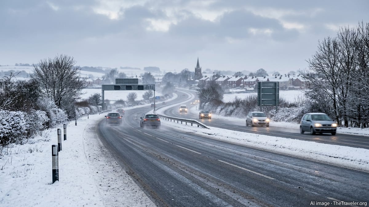
Snow showers and ice risk for roads and rail
Weather guidance points to frequent showers feeding in from the north and northwest, falling as a mix of rain, sleet and snow depending on elevation and intensity. Over higher routes in Scotland, northern England and parts of Wales, snow is expected to settle, with local accumulations building where bands of showers line up over the same areas.
Transport updates from previous cold spells this season show that even a few centimetres of wet snow can quickly affect exposed roads and rail lines, particularly where strong crosswinds cause drifting. Steeper trans-Pennine routes, upland stretches of the A9 in Scotland and rural routes in northern Wales are among those that have seen earlier disruption when similar conditions have developed.
Rail operators have previously reduced speeds or altered timetables during wintry showers to manage the risk of slippery rails and signalling faults, and similar precautionary measures are possible if snowfall intensifies this weekend. Local authorities and trunk road agencies are expected to continue gritting operations, but showers arriving after treatment can still lead to sudden icy patches, particularly overnight and in the early morning.
Travel information services are advising drivers to check route-specific forecasts and live traffic updates before setting off, and to be prepared for slower journeys where snow showers coincide with peak travel periods. Those using rural or minor roads are being encouraged to plan alternative routes where possible, as these are often the first to be affected by lying snow and ice.
Airports and ferry services watching conditions closely
Airports across the UK have already experienced weather disruption earlier in the winter, with published reports detailing temporary runway closures and de-icing delays during heavy snow events and strong winds. With another cold snap approaching, aviation forecasts are again highlighting the possibility of snow showers, low cloud and gusty winds affecting take off and landing windows at times.
Short, intense snow showers can reduce visibility and leave a thin covering of snow or slush on runways, leading to short-notice pauses in operations while clearing takes place. Even when skies appear clear nearby, bands of showers approaching from the sea can move over an airport within minutes, complicating schedules and causing knock-on delays.
Ferry services around the Irish Sea, the English Channel and the North Sea are also sensitive to this pattern of cold, unstable air and strong winds. While significant gales are not guaranteed throughout the weekend, forecasts describe periods of choppy seas and squally showers that may force timetable adjustments, particularly on smaller crossings and island links.
Passengers with flights or ferries booked over the weekend are being urged by operators, via public statements and online updates, to monitor departure boards closely and allow more time at ports and terminals in case of weather-related changes.
Regional contrasts across the UK
The impact of the cold snap is expected to vary widely by region. Scotland and northern England are most likely to see the heaviest and most frequent snow showers, especially across the Highlands, Grampians, Pennines and higher parts of Cumbria and Northumberland. Here, travel disruption is most probable, with some upland routes at risk of temporary closure if snow accumulates quickly.
In Wales, guidance suggests wintry showers will be most frequent across the north and west, including Snowdonia and higher ground in mid-Wales. Lower-lying coastal areas may see a mix of rain and sleet, but temperatures will still be low enough for ice to form overnight where surfaces remain wet.
Across the Midlands and parts of southern England, including the Home Counties, the air will be cold enough for occasional sleet or wet snow, particularly during heavier showers and overnight. However, any accumulations at lower levels are expected to be patchy and short-lived, with the main hazard coming from icy stretches on untreated roads and pavements.
Farther south and in parts of southwest England, the influence of relatively milder sea air means precipitation is more likely to remain as rain or hail, though temperatures will still feel distinctly wintry for mid-March. Travellers in these regions may avoid snow, but can still encounter sudden downpours, blustery winds and reduced visibility on exposed roads.
Advice for travellers and weekend planners
Public travel guidance issued during similar recent cold spells highlights a few consistent themes for staying safe on the move. Drivers are encouraged to check that vehicles are fuelled, equipped with warm clothing, phone chargers and basic emergency supplies, and that tyres and windscreen wash are suitable for winter conditions.
Rail and bus passengers are advised to build extra time into connections, as even minor timetable changes caused by snow or ice can lead to missed links on busy weekend routes. Keeping an eye on operator apps and station departure boards can help travellers adapt quickly if services are amended or cancelled at short notice.
For those planning domestic breaks or day trips, especially to upland national parks or coastal walking routes, experts recommend flexibility. Choosing activities that can be adjusted around showers, checking mountain and coastal forecasts, and having a wet or wintry weather backup plan can all reduce the risk of being caught out by rapidly changing conditions.
While the cold snap is not expected to last indefinitely, forecasts indicate that wintry showers and below-average temperatures could persist into the start of next week in some areas. Travellers across the UK are therefore being encouraged to treat this weekend as a period of heightened weather risk, staying informed and ready to adapt plans as the situation evolves.