
More news on this day
UK holidaymakers planning trips to Tenerife, La Palma and mainland Portugal are being urged to monitor forecasts closely as a powerful Atlantic weather pattern keeps parts of the Canary Islands and the Iberian coast under some of the highest weather risk categories used by European forecasters.
Get the latest news straight to your inbox!
Stormy Season Continues Across Atlantic Holiday Hotspots
The latest phase of an exceptionally active 2025 to 2026 storm season in Europe is continuing to drive unsettled and, at times, dangerous weather towards popular winter-sun destinations. Successive deep Atlantic low-pressure systems have been funnelling strong winds, heavy rain and large swells toward the Canary Islands and Portugal, leading to frequent high-level alerts for coastal and mountain areas.
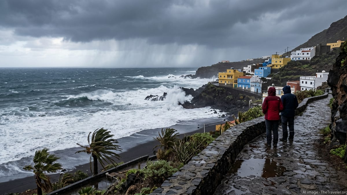
In the Canary Islands, Tenerife and La Palma have repeatedly featured in regional warning bulletins, with Spain’s state meteorological service placing the archipelago under yellow and orange alerts on several occasions for intense showers, mountain snow and rough seas. Recent coverage of this stormy spell has highlighted episodes of flash flooding, temporary road closures and disruption to local events, particularly when downpours have coincided with high tides.
Portugal has also been exposed to a series of powerful Atlantic storms during late January and February, with national reports describing a “train” of weather systems bringing repeated heavy rain and damaging winds. Public information from Portuguese and international outlets has underlined the cumulative impact of these storms, including river flooding, coastal damage and pressure on transport links.
Meteorologists describe this pattern as part of a broader European windstorm season in which several named storms have tracked further south than usual, putting holiday regions that are typically sheltered from the worst winter weather under a higher risk band for short, intense episodes.
Tenerife and La Palma: Heavy Rain, High Waves and Mountain Snow
Within the Canary Islands, Tenerife and La Palma have seen some of the most challenging recent conditions. Regional emergency plans have been activated in response to forecasts of heavy rain and strong winds, with public advisories noting the potential for rapid runoff in ravines, rockfalls on mountain roads and waves several metres high along exposed Atlantic coasts.
On higher ground, such as the peaks of La Palma and the slopes of Mount Teide in Tenerife, cold upper air has occasionally turned heavy showers into snow or sleet. While these wintry scenes can be striking, they also increase the risk of icy surfaces and temporary road closures on routes that are popular with visitors seeking viewpoints above the clouds.
Coastal areas have at times been affected by large Atlantic swells driven by distant storm systems. Forecasts have referenced waves in the four metre range and, in some cases, even higher seas for particularly exposed stretches. Combined with strong onshore winds, these conditions raise the risk of overtopping along promenades, temporary closure of beach access points and hazardous conditions for small boats.
Local media in the islands have stressed that conditions can vary sharply over short distances. While resort areas on the leeward coasts may experience intermittent showers and gusty winds, the windward slopes and high passes can see much more severe weather, making it important for visitors to check route-specific information before setting out.
Portugal Still Managing Impacts After Successive Severe Storms
On the Iberian mainland, Portugal is still contending with the aftermath of a sequence of powerful storms that peaked between late January and mid February. National summaries of those events describe extensive damage to infrastructure, widespread power cuts and significant economic losses, especially after one storm was assessed as the most costly in the country’s modern meteorological record.
Heavy rainfall over already saturated river basins led to flooding along major rivers, including the Douro, Tagus and Mondego, as well as in low-lying urban districts. Images from affected regions showed inundated streets, damaged riverfronts and residents moving through floodwater to reach essential services.
Coastal districts also saw some of the most dramatic conditions, with the national meteorological service issuing amber and, in some instances, higher-level coastal alerts for very rough seas. Reports indicated waves reaching many metres in height along the Atlantic coast, where popular viewpoints and seafront promenades were temporarily closed during peak conditions.
While the most extreme phase of the storms has now passed, the UK government’s latest travel advice for Portugal continues to reference “ongoing risks following a period of severe weather,” noting that some central regions are still dealing with landslides, debris and infrastructure damage. Travellers are being advised that road closures, diversions and intermittent disruption to public transport remain possible in certain areas.
What the Latest Official Travel and Weather Advice Says
For UK travellers, the most relevant official reference point remains the Foreign, Commonwealth and Development Office travel advice, which is updated as conditions evolve. The Portugal travel advice page, refreshed in February and still in effect as of 12 March 2026, highlights the recent severe weather and flags the potential for continuing disruption in regions that experienced repeated flooding.
The same guidance encourages travellers to follow local instructions, check national and European meteorological services for the latest warnings and allow extra time for journeys where damage or clean-up operations might still affect roads and rail lines. Although the advice does not currently advise against travel to Portugal, its wording underscores that the recent storms have left a legacy of higher-than-usual weather-related risks in some areas.
In Spain and the Canary Islands, weather alerts are primarily issued by the national meteorological agency and regional governments. Publicly available bulletins classify alerts from yellow through orange to red, with red typically reserved for the highest level of risk, when there is a greater likelihood of serious disruption to daily life and a greater chance of damage to property or danger near exposed coastlines.
Across Europe, these systems are designed to give residents and visitors early notice of potentially hazardous conditions. The recent stormy period has prompted renewed emphasis in public information campaigns on understanding warning colours, checking forecasts before travelling and recognising how quickly conditions can change in mountainous or coastal terrain.
Guidance for UK Tourists Planning Trips in the Coming Weeks
For UK tourists with holidays booked to Tenerife, La Palma or Portugal in late March and April, the message from recent public information is not to cancel outright, but to treat weather as a key planning factor. Airlines, tour operators and hotels in these destinations are accustomed to dealing with winter and early spring storms, but travellers may face occasional schedule changes or itinerary tweaks when the highest levels of weather warning are in force.
Practical steps recommended in official and expert guidance include monitoring destination forecasts in the days leading up to departure, enabling travel alerts from providers, and ensuring that travel insurance covers delays and disruption linked to adverse weather. Visitors planning road trips or hikes should be prepared for last-minute closure of mountain passes, cliff paths or coastal roads when heavy rain, strong winds or large waves are expected.
Beachgoers are also being reminded that sea conditions can remain dangerous even after skies begin to clear. Large swells generated by distant storms may arrive on otherwise bright days, and rip currents and powerful shore breaks can pose risks to swimmers and surfers when weather services continue to flag high-risk sea states.
As Europe’s storm season gradually gives way to more settled spring conditions, forecasters expect fewer high-end alerts, but the recent pattern has shown how quickly a new Atlantic system can raise the risk profile again. For now, UK tourists heading to Tenerife, La Palma and Portugal are being encouraged to keep an eye on the latest information and to build flexibility into their plans so that they can adapt if another period of “highest risk” weather develops.