
Arkansas rewards road trippers willing to slow down and follow its winding mountain highways, river valleys, and forested backroads. This ultimate Arkansas road trip itinerary ties together the state’s most compelling landscapes, national and state parks, historic spa town, and small-town stops, creating a loop that showcases why it is known as the Natural State. Designed for roughly 7 to 10 days behind the wheel, it can be shortened or extended, but the sequence and highlights below will help you make the most of every mile.
How Long to Spend and When to Go
For most travelers, 7 to 10 days is a sweet spot for an Arkansas road trip that feels unhurried yet still covers the hot springs, mountain byways, and river valleys that define the state. With a week you can explore Hot Springs National Park, drive scenic Highway 7 into the Ouachitas, then continue north into the Ozarks for Buffalo National River and the high country around the Pig Trail Scenic Byway. With 10 days or more, you can add side trips to places such as Blanchard Springs Caverns and the folk music hub of Mountain View, plus build in extra time for hiking, paddling, and lingering in small towns.
Season matters on a trip like this. Spring and fall are widely considered the most rewarding times to drive Arkansas, with mild temperatures, dogwoods and redbuds blooming in March and April, or fiery foliage in late October along byways such as Arkansas Scenic 7 and the Boston Mountains Scenic Loop. Summer brings long days and warm lake water, ideal for swimming and paddling, but humidity and heat can be intense in the lowlands and popular sites will be busier. Winter road trips can be quietly beautiful, especially around Hot Springs National Park, which has become a noted cold-season getaway thanks to its steaming thermal waters and historic bathhouses, though occasional ice or snow in the Ozarks can affect mountain driving.
Regardless of season, build flexibility into your schedule. Arkansas weather can shift quickly, and some activities such as floating sections of the Buffalo National River depend on water levels. Having an extra day in your plan lets you wait out a storm, adjust a hike, or simply stay longer in a town that surprises you. Fuel up regularly in rural stretches, and confirm opening hours in advance for attractions with seasonal schedules, especially small museums, caves, and gardens.
Starting in Little Rock: Capital City and Gateway
Little Rock works well as a starting point thanks to its central location, interstate access, and commercial airport. Before pointing the car toward the mountains, many visitors spend a partial day in the compact downtown and riverfront districts, where you can stretch your legs along the Arkansas River, explore museums, and get an initial feel for the state’s history and food scene. While this itinerary focuses on natural landscapes, giving yourself at least an afternoon in the capital provides helpful context for the rural communities you will visit later.
From Little Rock, the road trip naturally divides into two main arcs: the Ouachita Mountains and spa country around Hot Springs to the southwest, and the Ozark Mountains and Buffalo National River to the north. The suggested route heads first for Hot Springs, about an hour’s drive away, then continues in a wide loop through the Ozarks before returning toward the capital area. This order keeps daily driving distances manageable, typically between two and four hours, and lines up the most winding mountain roads for days when you are not racing sunset.
As you leave the city, you will notice how quickly the landscape changes from urban sprawl to piney woods and rolling hills. This transition hints at what defines an Arkansas road trip: the feeling that civilization drops away quickly, replaced by lakes, ridgelines, and small communities that still revolve around the rhythms of the land. It is worth stocking a cooler with water and snacks in Little Rock, since backroad stretches between state parks and byways can be long on scenery but short on services.
Hot Springs National Park and the Ouachita Lakes
Hot Springs, set in the Ouachita Mountains about 50 miles from Little Rock, is one of the most distinctive road trip stops in the region. The town developed around naturally flowing thermal springs that emerge at roughly 143 degrees Fahrenheit after a journey of thousands of years underground, and by the late 1800s Bathhouse Row had earned Hot Springs the nickname “The American Spa.” Today the historic line of eight bathhouses built between the 1890s and early 1920s anchors Hot Springs National Park and gives visitors a chance to soak in the same mineral-rich waters that drew travelers a century ago.
Plan to spend at least one full day, and ideally two nights, here. A classic visit combines a therapeutic soak or spa treatment in one of the operating bathhouses with a walk along the Grand Promenade and a short hike on the wooded trails that climb behind town. The national park protects both the springs themselves and the forested slopes of Hot Springs Mountain and North Mountain, where more than two dozen miles of paths offer shady viewpoints across the Ouachita range. Some travelers choose to ride the elevator to the top of the Hot Springs Mountain observation tower for a sweeping look at the surrounding hills and lakes.
Beyond the bathhouses, the wider Hot Springs area has become a year-round outdoor hub. Nearby lakes such as Hamilton and Catherine provide opportunities for boating, fishing, and swimming, while Lake Catherine State Park southeast of town offers cabins, campgrounds, and a compact trail network in a wooded setting built partly by the Civilian Conservation Corps in the 1930s. To the south and west, the forested ridges of the Ouachita National Forest hold quieter campgrounds and trailheads within easy driving distance, giving road trippers a chance to pair spa days with nights under the stars.
Many visitors also make time for Garvan Woodland Gardens, a roughly 210-acre botanical and woodland garden on a peninsula of Lake Hamilton that is known for its seasonal displays, Japanese-style landscapes, and lakeside walking paths. Whether you are most interested in architecture, formal plantings, or simple shoreline strolls, the gardens can easily fill half a day and serve as a peaceful counterpoint to the bustle of Bathhouse Row.
Driving Scenic Highway 7 into the Ouachitas
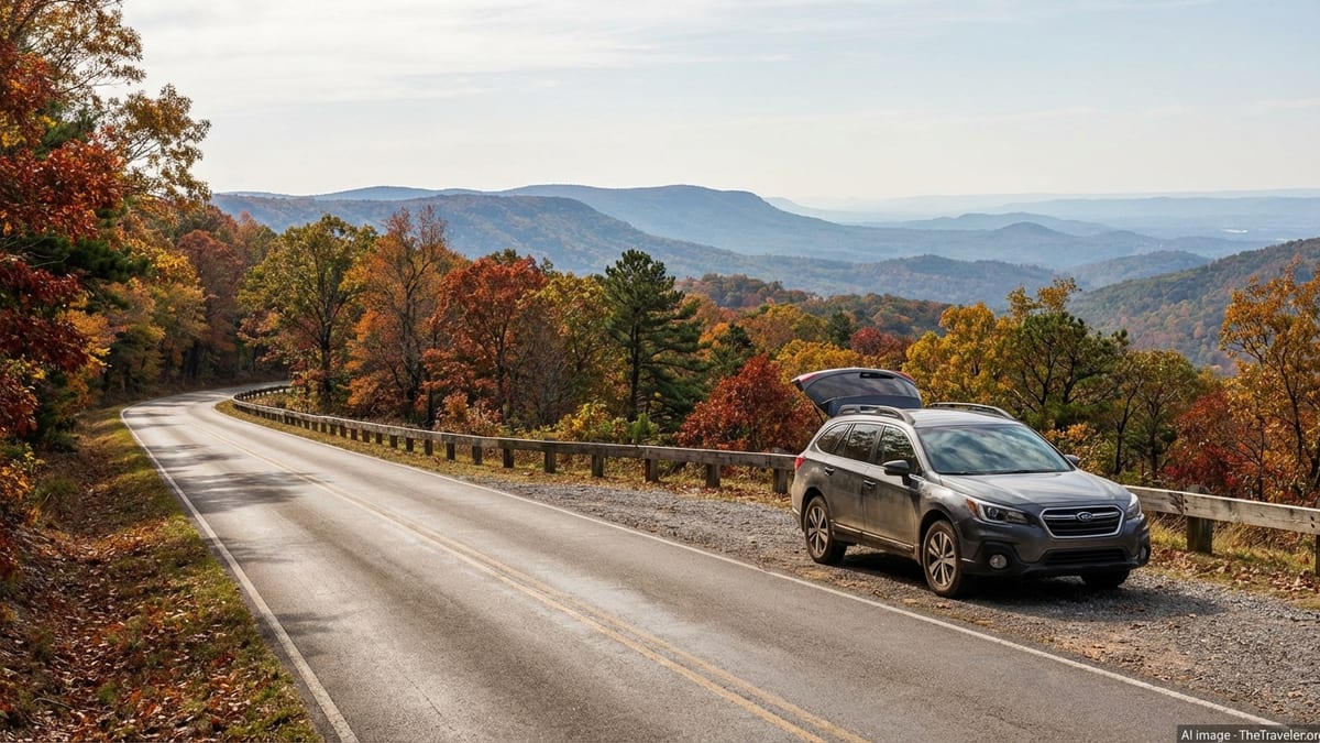
Leaving Hot Springs, a classic Arkansas driving day follows Arkansas Scenic 7, one of the state’s designated scenic byways, as it winds north through the Ouachita Mountains toward the Arkansas River Valley. This route has long been celebrated for its combination of forested ridges, river crossings, and small-town glimpses of everyday life, and it is particularly attractive in autumn when oaks and maples along the roadside turn shades of red and gold. Unlike an interstate, Highway 7 invites a slower pace and frequent pullouts to appreciate the views.
As you drive, you will notice how the road alternates between climbing wooded slopes and dropping into valleys where small farms and pastures line creeks. Modest roadside overlooks and picnic areas provide chances to step out, breathe in the pine-scented air, and photograph the layered hills. The entire Scenic 7 corridor offers access to numerous state parks and recreation areas, so it is worth researching a few short hikes or waterfalls that match your interests and fitness level before you set out. Even without a major stop, the drive itself is a highlight, especially for travelers who enjoy curving two-lane roads.
A natural place to pause is in the vicinity of the Arkansas River Valley, where you can either turn east for a quicker path toward the Ozarks or continue west to add a side trip into Mount Magazine Scenic Byway country. Mount Magazine, the state’s highest point at 2,753 feet, rises prominently above the surrounding landscape and offers hiking, rock climbing, and panoramic views when the weather cooperates. Whether you choose the detour or stick to the main route, consider this day as a transition between the spa atmosphere of Hot Springs and the rugged highlands that await farther north.
Into the Ozarks: Boston Mountains and Scenic Byways
From the Arkansas River Valley, your route bends into the Ozark Mountains, where elevations rise, traffic thins, and the driving becomes more technical. This region is laced with a network of recognized scenic byways, including the Boston Mountains Scenic Loop, the Ozark Highlands Scenic Byway, and the Pig Trail Scenic Byway. Collectively, these routes give road trippers access to high ridges, deeply cut hollows, and travel experiences that feel far removed from interstate corridors.
The Boston Mountains Scenic Loop combines an older two-lane route and a modern interstate that both cross the rugged Boston Mountains between the river valley and the college town of Fayetteville. The traditional highway is slower but more intimate, with closer views of farmsteads and forest. Many drivers mix the two, taking the interstate in one direction and the old road in the other. Near the top of the range, pullouts reveal wide panoramas of oak and hickory forest stretching away in waves, especially appealing when autumn colors peak.
To the east, the Ozark Highlands Scenic Byway and Highway 21 thread through some of the state’s wildest-feeling country, linking small communities, river access points, and trailheads. Farther west, the Pig Trail Scenic Byway, a twisting section of Highway 23 through the Ozark National Forest, has achieved a kind of cult status among motorcyclists and sports car drivers thanks to its combination of hairpin turns, steep grades, and close-set hardwood forests. Regardless of which byways you include, expect lower average speeds, frequent elevation changes, and the need for attentive driving, especially after dark or in wet conditions.
Plan at least two days in the Ozark highlands, though hikers, paddlers, and photographers may happily spend longer. Lodging and camping are spread among small towns and national forest campgrounds, so it often makes sense to pick a base town such as Jasper or Ponca and make day trips from there. This approach cuts down on daily packing and unpacking and gives you a chance to get to know a particular community, from its diner breakfasts to its evening conversations outside the general store.
Buffalo National River: Cliffs, Elk, and Classic Trails
Buffalo National River, which flows freely for more than 130 miles through northern Arkansas, is a centerpiece of many road trips in the state and deserves at least two days of your itinerary. The upper district around Ponca and Boxley is particularly dramatic, with tall limestone bluffs, clear pools, and forested slopes that turn brilliant shades in fall. The corridor is managed as a national river, offering a mix of developed campgrounds, primitive sites, and river access points suitable for paddling when water levels allow.
One of the defining experiences here is simply driving the valley roads at dawn or dusk to look for the resident elk herd. Boxley Valley, a historic district along the upper river, is widely known as one of the best places in Arkansas to see wild elk, which were reintroduced after being extirpated and now number in the hundreds. Travelers cruising the short stretch of highway between the small communities of Boxley and Ponca at the right times of day often spot elk grazing in fields or crossing near the river, especially in cooler months.
On foot, several trails stand out. Lost Valley, near Ponca, is a popular route of roughly 2.5 miles round trip that follows a creek into a box canyon dotted with waterfalls, caves, and interesting rock formations. Farther along the river corridor, numerous other paths climb to overlooks, trace side canyons, or lead to historic homesteads that illustrate how early settlers carved out a life in this rugged country. The national park service maintains updated information on seasonal conditions, closures, and recommended hikes, so it is wise to check in with a visitor center when you arrive.
Paddling the Buffalo in a canoe or kayak is a coveted experience, but it depends heavily on rainfall and river gauges, particularly in the upper sections where flows can fluctuate quickly. Outfitters in towns along the river can advise on which stretches are currently floatable, what skill level is required, and whether a shuttle is necessary. Even if conditions are not right for a float, separate river access sites provide scenic picnic spots and chances to wade, photograph reflections, or simply listen to the water slipping past.
Mountain Towns, Caverns, and Folk Music
As you work your way east from the Buffalo corridor, consider adding time in a few of northern Arkansas’s small towns that have built reputations around music, crafts, and nearby natural attractions. Mountain View, billed as a center for traditional Ozark folk music, hosts regular informal jam sessions on the courthouse square in warmer months, along with festivals and performances that celebrate fiddle tunes, ballads, and regional dance. Even on quiet weekdays, you can often find live acoustic music in local parks or gathering spots, and shops around town showcase locally made instruments and crafts.
Not far away, the Blanchard Springs area combines a significant limestone cavern system with streams, waterfalls, and forested trails. The caverns have long operated with guided tours through chambers decorated with stalactites and other formations, and state and federal agencies have been working to formally designate the broader site as a state park, reflecting its role as an anchor for outdoor recreation in the region. Above ground, walking paths take in spring-fed pools and cascades, while nearby campgrounds and picnic areas make the area a good stop for families and road trippers who appreciate both geology and easy-access nature.
Other communities in the northern part of the state, such as Eureka Springs and Harrison, can fit naturally into an Ozark road trip, depending on your exact route and interests. Some are known for preserved Victorian architecture and hillside streets, others for proximity to lakes and fishing, and many for a blend of the two. The key is to choose one or two towns that align with your priorities, whether those are small galleries, historic hotels, or simple motels and diners where you can refuel between hiking days.
Spending nights in these towns rather than pushing long drives after dark also increases safety. Wildlife such as deer and smaller animals are common near roadways in the Ozarks, particularly at dawn and dusk, and the combination of curves, limited shoulders, and occasional fog means it is often wiser to arrive in the afternoon, explore on foot, and enjoy local music or food before resting up for the next morning’s drive.
Looping Back: Delta Detours or Return to the Spa
Once you have explored the Ozarks and Buffalo National River, you will begin looping back toward your starting point. At this stage of the itinerary, you have a decision to make: head directly south and west toward Hot Springs and Little Rock, revisiting your favorite spots along the way, or arc east toward the Arkansas Delta and Crowley’s Ridge before returning to the capital. Both options provide satisfying closure to the trip, depending on how much time remains and how many hours you wish to spend behind the wheel on your final days.
Turning east introduces a different side of Arkansas, where the flat Mississippi Alluvial Plain meets a narrow geological uplift known as Crowley’s Ridge. The Crowley’s Ridge Parkway is one of the state’s recognized scenic routes, offering viewpoints over hardwood forests that stand slightly above surrounding farm fields, along with access to state parks, small towns, and sections of the Great River Road that parallels the Mississippi. Travelers interested in civil rights history, blues music, or agricultural heritage often appreciate this detour, which contrasts sharply with the mountainous terrain you have just left.
If instead you choose to head straight back toward Hot Springs and Little Rock, you can use the return leg to catch sights you might have missed on the way north. Perhaps you did not have time to sample a different trail along Scenic 7, or you want another evening in the thermal baths before flying home. Because distances in Arkansas are relatively modest, it is usually possible to fit one more hike, soak, or lakeside picnic into your final full day without an exhausting drive. Plan to arrive back in Little Rock with enough cushion before any onward flights, remembering that rural traffic incidents or weather can still slow progress.
Whichever closing route you choose, the key is to resist the urge to rush. One of the pleasures of an Arkansas road trip is the chance to notice how the landscape subtly shifts, from limestone bluffs to river bottomlands, from pine forests to agricultural fields. Let the final miles be an extension of the journey rather than just a commute, stopping in a small-town café or roadside produce stand if one catches your eye.
The Takeaway
An ultimate Arkansas road trip is less about ticking off famous landmarks and more about weaving together a series of distinct but complementary landscapes. Hot Springs National Park’s historic bathhouses and steaming fountains provide a sense of continuity with travelers who came generations ago seeking the same waters. Scenic byways through the Ouachita and Ozark Mountains deliver curves, overlooks, and small towns that reward the unhurried driver. The Buffalo National River offers a rare combination of free-flowing water, high bluffs, and wildlife such as elk that have reclaimed a foothold in the valley. Folk music squares, cavern tours, lakeside trails, and delta detours all add texture to the route.
By allowing at least a week, choosing a favorable season, and maintaining flexibility in your plans, you can build an itinerary that feels tailored to your own pace and interests. Some travelers will prioritize hot springs and spa time paired with gentle walks, while others will focus on backcountry hikes, paddling days, and mountain driving. Either way, the distances are short enough and the options varied enough that you rarely need to choose between nature and culture, or between rest and adventure.
In the end, many road trippers come away remembering not just the marquee views from an overlook or bathhouse porch, but also the simple moments that unfolded in between: fog lifting off a river at dawn, a conversation with a local at a gas station, the quiet of a starry night in a forest campground. Arkansas excels at those unscripted interludes. Build them into your plan, and the miles you cover will feel less like a checklist and more like a genuine journey through the Natural State.
FAQ
Q1. How many days do I need for an Arkansas road trip?
Most travelers find 7 to 10 days ideal, which allows time for Hot Springs, at least one scenic byway, Buffalo National River, and a couple of small-town stops without rushing.
Q2. What is the best time of year to drive this Arkansas itinerary?
Spring and fall offer the most comfortable temperatures and the best scenery, with spring wildflowers and fall foliage especially striking along mountain byways and river valleys.
Q3. Is this Arkansas road trip suitable for families with children?
Yes, the itinerary works well for families, especially if you include short hikes, lake swimming, and kid-friendly stops such as lakeside state parks, gardens, and easy cavern tours.
Q4. Do I need a four-wheel-drive vehicle for Arkansas scenic byways?
Most major scenic byways and access roads on this route are paved and suitable for standard vehicles, though caution is wise on steep, curvy sections, especially in wet or icy weather.
Q5. Can I drive this route in winter?
It is possible, and Hot Springs can be especially appealing in cooler months, but occasional snow or ice in the Ozarks may affect high-elevation roads, so monitor forecasts and stay flexible.
Q6. Is it easy to find lodging and camping along the way?
Lodging and campgrounds are available around major hubs such as Hot Springs and Buffalo National River, but availability can tighten in peak seasons, so advance reservations are recommended when possible.
Q7. Do I need permits or reservations for Buffalo National River activities?
General access to the river corridor typically does not require permits, but commercial outfitters, developed campgrounds, and certain facilities may need reservations, especially for peak weekends and holidays.
Q8. Are there good options for travelers who do not hike much?
Yes, many highlights are accessible from scenic drives, overlooks, visitor centers, gardens, and short, relatively level walks, allowing non-hikers to enjoy the landscapes without strenuous exertion.
Q9. How should I prepare for wildlife on the road and trails?
Expect deer and smaller animals near roads, especially at dawn and dusk, and give them space on trails; drive cautiously at night and secure food properly in campgrounds and picnic areas.
Q10. Can I customize this itinerary into a shorter long-weekend trip?
Absolutely, you can focus a three- or four-day trip on Hot Springs and one nearby scenic corridor, or on Buffalo National River and an Ozark base town, then return for a longer loop another time.