
Driving California’s Pacific Coast Highway is one of the classic road trips in the United States, a ribbon of asphalt that clings to cliffs, dips into beach towns, and threads through working harbors and redwood forests. With Highway 1 now fully reconnected through Big Sur as of January 2026, travelers can once again experience the entire coastal journey in a single epic itinerary, provided they keep a close eye on short term weather related closures. This guide outlines a practical south to north route, key stops, and up to date planning advice to help you make the most of an ultimate Pacific Coast road trip.
Why Drive California’s Pacific Coast Now
In early 2026, Highway 1 along Big Sur officially reopened end to end after several years of landslide related disruptions, restoring one of the most spectacular coastal drives in the world. Recent storms can still trigger temporary rockslides and debris, but travelers once again have the option to link San Diego, Los Angeles, Big Sur, and the North Coast in a single continuous trip. Planning with the latest road reports and some flexibility can transform potential hassles into manageable detours.
Unlike interstate highways that bypass scenery, Highway 1 and connecting coastal routes pass directly through historic downtowns, surf towns, fishing piers, and agricultural valleys. You can watch surfers paddle out at sunrise, walk out to a working wharf for clam chowder at lunch, then end the day above pounding surf as fog drifts through the cypress trees. The route rewards unhurried travel, where short driving days and frequent stops matter more than ticking off miles.
Because segments of Highway 1 remain vulnerable to winter storms, especially around Big Sur and parts of Mendocino County, it is wise to treat any itinerary as a flexible framework rather than a rigid schedule. Build in buffer time, check conditions with Caltrans and local visitor centers before driving isolated stretches, and prepare for one way traffic controls where repair work continues. With that in mind, the following sections outline a realistic south to north route that usually takes 7 to 14 days, depending on how deeply you want to explore.
Starting in San Diego: Beaches, Culture, and Easy Miles
Beginning in San Diego allows you to ease into the road trip with short, straightforward driving days and an international airport that often has competitive rental car options. Spend one or two nights here to shake off jet lag and get a feel for Southern California’s coastal rhythm. La Jolla’s sea cliffs, Coronado’s wide sandy beach, and the Gaslamp Quarter’s nightlife offer a broad first taste of the state’s beach culture and urban energy.
When you leave San Diego, northbound Interstate 5 and local coastal roads let you hop between classic surf towns like Encinitas, Carlsbad, and Oceanside. The driving is gentle compared with what comes later around Big Sur, so this is an ideal stretch to adjust to local traffic patterns, get comfortable with your vehicle, and pick up any gear you forgot. Coastal rail lines, bluff top trails, and beachside cafes run almost continuously through this section, making spontaneous stops easy.
Spring and fall often provide the most pleasant combination of milder temperatures, calmer crowds, and fewer weather disruptions along the San Diego coast. In winter, you may encounter cooler water and some stormy days, but highway closures in this far south region are relatively rare compared with central and northern portions of Highway 1. Summer brings heavy beach traffic and higher prices, but also long daylight hours that make it easier to explore after your daily drive.
From Orange County to Los Angeles: Urban Coastline and Iconic Landmarks
North of San Diego, the route shifts from relaxed surf enclaves to more built up coastal communities in Orange County and the greater Los Angeles area. Newport Beach, Laguna Beach, and Huntington Beach line the shore with harbors, art galleries, and long surfing beaches. Although much of this segment uses multi lane highways rather than a twisting cliff road, it still offers distinctive experiences, from tide pools and waterfront promenades to lively pier scenes.
Approaching Los Angeles, many travelers choose to detour inland briefly to explore cultural institutions and neighborhoods away from the immediate coast. Downtown Los Angeles, Hollywood, and areas like Silver Lake or Echo Park provide a contrast to the seaside focus of the rest of the road trip. If time is limited, you can instead follow the coastal route through places such as Santa Monica and Malibu, which combine ocean views with easy access to restaurants, shopping, and short hikes into the Santa Monica Mountains.
Driving through the Los Angeles region requires patience. Schedule your departure and arrival times to avoid weekday rush hours where possible, and accept that traffic jams are part of the experience. Using this stretch as a chance to slow down, stop at a beach for sunset, or linger over dinner can make the urban portion of the journey feel less like an obstacle and more like another facet of California’s coastal story.
Santa Barbara, Central Coast Wine Country, and Hearst Castle
Once you leave greater Los Angeles and follow the coast toward Ventura and Santa Barbara, the pace of the road trip changes dramatically. The terrain opens to agricultural fields and low hills, and the highway gradually feels less urban. Santa Barbara, often called the American Riviera, combines Spanish influenced architecture with palm lined waterfronts and a compact downtown. Many travelers choose to spend at least one night here to enjoy the walkable streets, nearby wineries, and mountain to sea views.
North of Santa Barbara, the Pacific Coast Highway and U.S. 101 swing inland and back out to the sea, passing through small communities such as Pismo Beach and the towns of the Santa Ynez Valley. This region has become a significant wine destination, with tasting rooms and vineyards spread across rolling hills. If you plan to sample local wines, designate a sober driver or base yourself for a night or two and join a guided tasting tour so that you can leave the car parked.
Continuing north, San Luis Obispo serves as a convenient base before you reach the more remote stretches of Highway 1. Nearby Morro Bay, with its working harbor and volcanic rock offshore, and the fishing village of Cambria offer a more low key coastal atmosphere. Just north of Cambria, Hearst Castle sits above the coastline, a historic estate open for guided tours. Allocating half a day here gives you time to explore the hilltop property and still reach your evening destination without rushing, especially during shorter winter daylight hours.
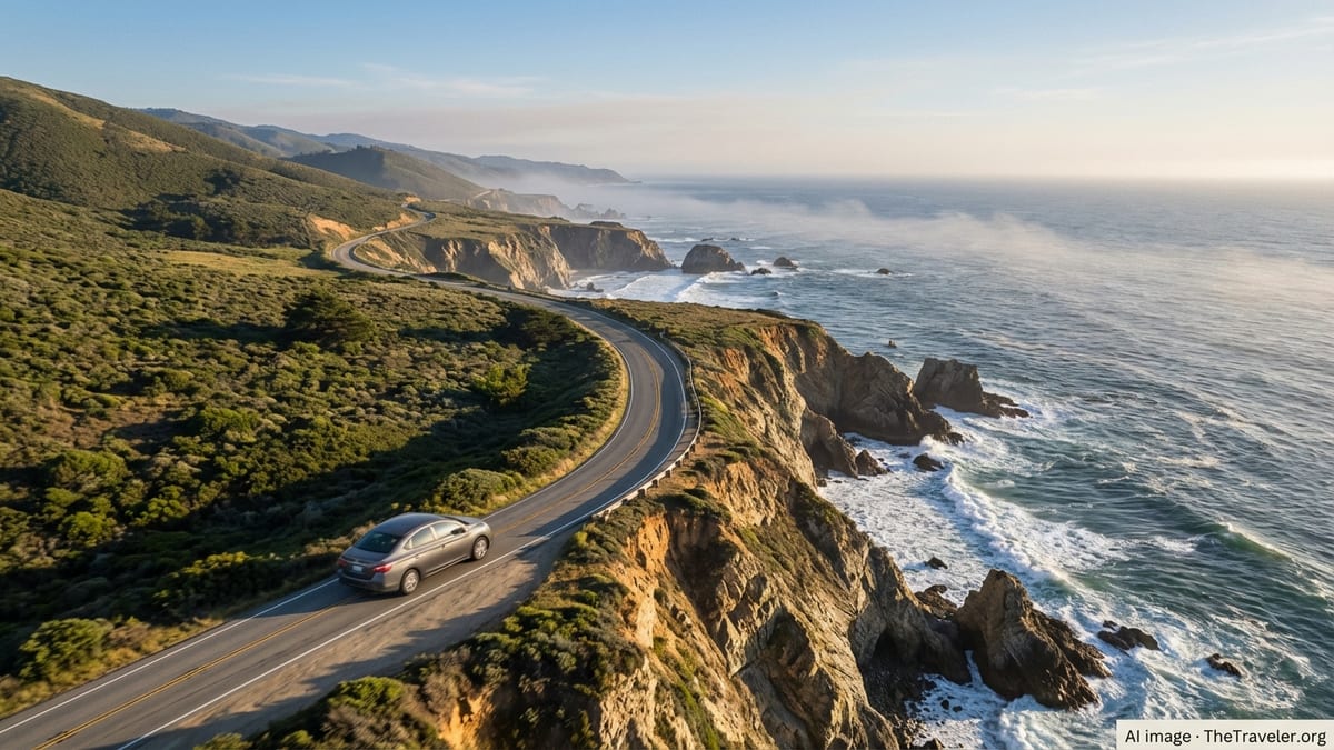
Big Sur: The Dramatic Heart of the Pacific Coast Highway
The drive from the San Simeon area into Big Sur is often the highlight of a Pacific Coast road trip, and as of January 2026 the full length of Highway 1 through this region has reopened after extensive landslide repairs. Even with the restoration of through access, it remains essential to check current conditions before departure, as heavy winter storms can still prompt temporary closures, rockfall cleanups, or one way traffic controls. Local visitor centers and official state transportation updates are the most reliable sources for day to day changes.
Allow at least one full day to drive the Big Sur section, even if the actual distance looks modest on a map. The road is narrow and twisting, with frequent pullouts where you will want to stop for views over sheer cliffs, hidden coves, and bridges framed by surf and fog. Popular spots include areas around Bixby Bridge, Pfeiffer Beach, and Julia Pfeiffer Burns State Park, where a waterfall drops directly to the sand. Parking at trailheads and viewpoints can fill quickly in peak seasons, so arriving early in the day helps you secure a space.
Services in Big Sur are limited compared with urban stretches of the route. Fuel stations, lodging, and dining are concentrated in a handful of clusters, and prices reflect the remoteness and the cost of supplying this region. Booking accommodations well ahead of time, especially in summer, holidays, and weekends, is strongly recommended. Carry extra water, snacks, and warm layers, as coastal fog and wind can make temperatures feel markedly cooler than inland forecasts suggest, even in the height of summer.
Monterey Bay to San Francisco: Marine Life and Classic Seaside Towns
North of Big Sur, the road gradually widens and the driving becomes less intense as you approach the Monterey Peninsula. Monterey, Pacific Grove, and Carmel by the Sea blend historic waterfronts, restored cannery buildings, and sandy beaches with world class aquariums and marine research centers. Whale watching tours, kayaking in protected bays, and simply walking along coastal paths provide opportunities to observe sea otters, harbor seals, and shorebirds in their natural habitat.
Continuing up the coast toward Santa Cruz, you move into a region known for surf breaks, boardwalk amusements, and redwood groves tucked just inland. The mix of classic beach town nostalgia and contemporary tech driven culture makes this stretch distinct. If your schedule allows, spending a night in Santa Cruz lets you explore both the waterfront and the nearby forested state parks, where towering coastal redwoods grow within a short drive of the ocean.
Approaching San Francisco, coastal routes and freeways intersect in complex ways, so studying your route in advance helps avoid last minute lane changes. Once in the city, you can either pause the road trip for a few nights of urban exploration or simply drive across the Golden Gate Bridge and continue toward the quieter reaches of Marin and Sonoma counties. San Francisco’s steep hills, compact neighborhoods, and microclimates mean that weather and visibility can change quickly, so be prepared for fog, wind, and rapidly shifting conditions around viewpoints.
North of San Francisco: Wild Coastlines and Redwood Country
For many travelers, crossing the Golden Gate Bridge feels like the end of the classic Pacific Coast Highway experience, but extending the journey north reveals some of California’s most dramatic and less crowded coastal landscapes. Marin’s headlands, Point Reyes National Seashore, and the small towns of the Sonoma Coast offer wind sculpted cliffs, long empty beaches, and estuaries rich in birdlife. Roads here are often narrower and more winding than their southern counterparts, and weather can be cooler and foggier even in midsummer.
Farther north, Mendocino County’s coastline alternates between pocket beaches, sea stacks, and pine topped headlands. The town of Mendocino, with its historic wooden buildings and coastal bluffs, provides a good base for exploring nearby state parks and tide pools. Recent storms have occasionally caused localized slides and short term closures on Highway 1 in this region, so the same caution that applies to Big Sur holds true here: check conditions before committing to remote stretches, especially in winter and early spring.
Eventually, Highway 1 connects with U.S. 101 and carries you into the redwood country of Humboldt County and beyond. Here, towering trees flank the roadway and short detours lead to groves where you can walk among some of the tallest living organisms on Earth. This northern segment feels more remote and less developed than the southern half of the trip, rewarding travelers who still have energy and time to push onward after the more famous sections around Big Sur and Monterey Bay.
Essential Planning Tips, Seasons, and Safety
Given the Pacific Coast Highway’s history of landslides, washouts, and temporary closures, especially near Big Sur, building flexibility into your plan is more important now than ever. Before you set out each day, particularly when driving isolated sections, review the latest information from state transportation agencies and local visitor organizations. Closures can evolve quickly after storms, and what was open in the morning may operate under new controls by nightfall.
When choosing your travel dates, consider both weather and crowd levels. Late spring and early fall often provide a balance of relatively stable conditions, green hills, and manageable visitor numbers. Winter can bring dramatic storm watching and lower prices but also higher chances of road disruptions, shorter days, and colder, wetter conditions. Summer offers long daylight hours and typically dry weather along much of the route, along with heavier traffic, fuller accommodations, and more competition for popular viewpoints and campgrounds.
Safety along the route involves more than watching for rockfall and construction zones. Drivers should be prepared for narrow shoulders, sharp curves without guardrails, and sudden changes in visibility due to fog. Take breaks often to avoid fatigue, rotate drivers if possible, and resist the temptation to look away from the road while driving in scenic sections. Use designated pullouts for photos rather than stopping in travel lanes, and be mindful that cell coverage can be unreliable in remote areas, so offline maps and printed confirmations remain useful backups.
The Takeaway
Completing an ultimate California road trip along the Pacific Coast is less about ticking off every recommended stop and more about embracing the journey’s variety. From the calm beaches of San Diego to the urban energy of Los Angeles and San Francisco, from the cliffs of Big Sur to the wind battered bluffs of the North Coast, the route strings together distinct regions that each deserve time and attention. With Highway 1 through Big Sur fully reconnected as of early 2026, travelers once again have the option to experience the continuity of the drive, provided they respect the landscape’s volatility and plan accordingly.
By allowing extra days, checking conditions regularly, and remaining open to detours, you can navigate around short term disruptions while still savoring the road’s highlights. Whether you spend a week focusing on the central stretch or two weeks tracing the coast from the Mexican border to the redwoods, the Pacific Coast Highway rewards curiosity and patience. It is a trip that combines iconic postcard vistas with the quieter pleasures of roadside farm stands, harborfront walks, and foggy mornings in small inns, leaving many travelers already plotting a return before they have even reached the end.
FAQ
Q1. How many days do I need for a full Pacific Coast Highway road trip?
Most travelers find that 7 to 10 days is the minimum for a one way trip from San Diego or Los Angeles to the redwood region without feeling rushed, while 12 to 14 days allows more time for side trips, extra nights in Big Sur, and weather related flexibility.
Q2. Is Highway 1 through Big Sur fully open in 2026?
As of January 2026, Highway 1 through Big Sur has been reconnected after major landslide repairs, but short term closures or one way traffic controls can still occur after heavy storms, so it is important to check conditions shortly before you drive that segment.
Q3. Which direction is better, northbound or southbound?
Both directions work, but many drivers prefer traveling southbound because it keeps them on the ocean side of the road for easier access to pullouts and coastal views, while others choose northbound for slightly less crowding at certain viewpoints; the choice largely depends on where you are starting and ending your trip.
Q4. What is the best time of year to drive the Pacific Coast Highway?
Late April through early June and September through October are often considered ideal because they typically combine milder weather, green hills, and somewhat lighter crowds, though conditions vary by year and winter storms can still affect road access in early spring.
Q5. Do I need a specific type of vehicle for this road trip?
You do not need a special vehicle for most of Highway 1, but a reliable car with good brakes, comfortable seats, and enough power for hills will make the twisting, hilly sections more pleasant, and larger vehicles such as RVs should be driven cautiously on narrow stretches.
Q6. How far in advance should I book accommodation along the route?
In popular areas like Big Sur, Santa Barbara, and the Monterey Peninsula, booking several months ahead for summer, weekends, and holidays is wise, while in shoulder seasons you may find more flexibility but should still secure key nights in advance to avoid long detours in search of vacancies.
Q7. Are there toll roads or fees on the Pacific Coast Highway?
The main sections of Highway 1 described in this itinerary generally do not involve tolls, though some bridges, optional scenic drives, and state park entrances may charge separate fees, so carrying a mix of cash and cards and checking local regulations beforehand is helpful.
Q8. Is the route suitable for families with children?
Yes, many families successfully drive this route, but it helps to plan shorter driving days, frequent breaks at beaches or playgrounds, and overnight stops with access to outdoor space, as some of the most beautiful sections have limited services and long runs between towns.
Q9. How can I stay informed about road closures while on the trip?
Before setting out each day, check official state transportation updates and local visitor center reports for your planned segment, and consider asking hotel or campground staff about recent conditions, since they often hear quickly about nearby slides, construction, or detours.
Q10. Is it safe to drive the Pacific Coast Highway at night?
While it is legal to drive the route at night, it is generally safer and more enjoyable to travel during daylight because many sections have sharp curves, limited lighting, and potential wildlife on the road, and you would miss much of the scenery that makes the trip special.