
On a sunlit peninsula south of Vancouver, Tsawwassen offers a distinctly relaxed slice of coastal British Columbia.
Here, sand flats stretch into Boundary Bay, ferries glide toward Vancouver Island and the Southern Gulf Islands, and miles of shoreline trails frame big-sky views of sea and mountains.
Whether you are bound for an island adventure or planning a quiet seaside escape, Tsawwassen rewards anyone who slows down long enough to explore beyond the ferry causeway.
Getting Oriented: Where Tsawwassen Sits on the Coast
Tsawwassen sits in the southwest corner of Delta, British Columbia, on a low peninsula bordered by the Strait of Georgia to the west and Boundary Bay to the east. It is roughly 35 to 40 kilometres south of downtown Vancouver, close to the Canada United States border crossings at Peace Arch and Point Roberts. The region is known for its comparatively dry and sunny microclimate, with estimates suggesting it receives significantly less rainfall than central Vancouver, which helps explain the area’s enduring popularity for beach days and coastal walks.
The town itself is compact, with residential streets radiating inland from the shoreline and main commercial services clustered along 56 Street and 12 Avenue. A short drive south along Highway 17 leads to the Tsawwassen ferry terminal, while smaller local roads branch off toward Boundary Bay Regional Park, Centennial Beach and the Southlands agricultural community. For visitors, this means you can stay almost anywhere in Tsawwassen and remain within a short drive or bike ride of both the beaches and the ferries.
Tsawwassen’s identity is tightly linked to the water. To the east, expansive tidal mudflats and salt marshes create essential habitat for migratory birds along the Pacific Flyway. To the west, the long ferry causeway extends into the Strait of Georgia, offering wide-open horizons and unobstructed sunset views. Within this setting, you can easily shape a visit around coastal scenery, whether that means walking the Boundary Bay dyke, watching ferries depart for Vancouver Island or simply settling into the sand as the tide creeps in.
Despite its relatively modest size, Tsawwassen functions as a regional gateway. Local residents embrace its small-town atmosphere, while travellers know it as the place you pass through on the way to Victoria, Nanaimo or the Southern Gulf Islands. This guide focuses on what happens when you stop treating Tsawwassen as a transit point and start treating it as a destination in its own right.
Centennial Beach: Shallow Seas and Big-Sky Horizons
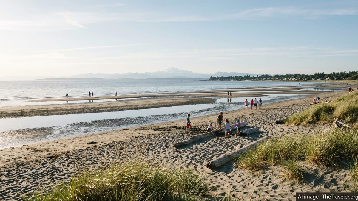
Centennial Beach, part of Boundary Bay Regional Park, is Tsawwassen’s signature stretch of shoreline and one of the warmest saltwater swimming spots in the Metro Vancouver region. The beach slopes gently into Boundary Bay, with broad intertidal sand and mud flats exposed at low tide. On summer afternoons, the combination of warm shallows, soft sand and expansive sky creates a distinctly laid-back holiday mood that feels far removed from the city, even though urban Vancouver lies just across the water.
At high tide, shallow water extends well inland, creating a calm and relatively warm area for wading and swimming that is especially popular with families. On clear days, distant views take in the snowy cone of Mount Baker in Washington State and the North Shore mountains framing Vancouver. At low tide, the sea retreats dramatically, revealing rippled sand patterns, tidal pools and stretches of eelgrass that invite slow, observant wandering. It is important to tread carefully in these sensitive zones, watching for posted signage that highlights protected habitats and seasonal bird activity.
Behind the beach, a network of walking paths connects picnic areas, open lawns and a sizeable playground that has been designed with accessibility in mind. In warmer months, a seasonal concession typically operates near the main parking area, offering snacks, drinks and simple beach fare. Basic amenities such as washrooms, outdoor showers and shaded picnic shelters make it easy to linger for a full day, even if you are visiting with young children or a multi-generational group.
Conditions at Centennial Beach change dramatically with the tide and the season, so it is wise to arrive prepared. On breezy days, wind can sweep across Boundary Bay, cooling the air even under bright sunshine, and in shoulder seasons the mud flats can feel exposed and chilly once the sun drops. Bringing layers, windbreakers and extra towels helps ensure you can enjoy the shoreline regardless of the weather. Parking near the main beach area can fill up on peak summer weekends, so arriving earlier in the day often leads to a more relaxed start.
Boundary Bay Regional Park and the Coastal Trails
Beyond the sandy stretch at Centennial Beach, Boundary Bay Regional Park protects a wide swath of shoreline, wetlands and old fields that extend north along the bay. Estimates suggest there are more than a dozen kilometres of official trails in and around the park, ranging from short interpretive loops through dune habitat to longer dyke-top routes suited to cycling and running. The overarching experience is one of open horizons, muted coastal colours and a sense of calm that comes from walking beside water and sky for extended stretches.
One of the most popular routes is the Dyke Trail that runs along the edge of Boundary Bay. Sections of this trail connect Centennial Beach with points farther north toward Mud Bay, forming part of a larger system of shoreline paths. The trail surface is generally flat and well maintained, welcoming walkers, runners, families with strollers and casual cyclists. As you move along the dyke, you pass salt marsh, tidal flats and occasional viewpoints furnished with benches or low rails, all oriented toward the bay and distant mountains.
Birdlife is a constant presence in Boundary Bay. The area lies on the Pacific Flyway, a key migratory route, and the combination of shallow water and exposed mudflats creates feeding grounds for shorebirds, ducks and raptors. Depending on the season, you may see flocks of sandpipers stitching along the water’s edge, bald eagles perched on driftwood or harriers floating low over the marsh. Several trails, including the Raptor Trail and Savannah Trail, wind through open fields and hedgerows that provide good vantage points for spotting birds of prey.
Respect for the park’s ecological sensitivity is central to a responsible visit. Dogs are welcome in some areas but must be leashed where indicated, and seasonal restrictions sometimes apply to protect nesting birds or resting migratory flocks. Staying on marked paths, avoiding trampling dune vegetation and keeping a respectful distance from wildlife help ensure the park remains a refuge for the species that depend on it. Simple choices, such as carrying out all litter and packing a reusable water bottle, reinforce the sense that Boundary Bay is both a local recreation area and a globally significant coastal ecosystem.
Tsawwassen Ferry Terminal: Gateway to the Islands
Tsawwassen ferry terminal, operated by BC Ferries, is one of the busiest marine transportation hubs on the British Columbia coast. Located at the western tip of the Tsawwassen peninsula, roughly 36 kilometres from downtown Vancouver, the terminal sits at the end of an elevated causeway that stretches across tidal flats and shallow water. From here, large double ended ferries depart for Swartz Bay near Victoria, Duke Point near Nanaimo and several of the Southern Gulf Islands, linking the mainland with Vancouver Island and smaller communities across the Salish Sea.
For most travellers, the terminal represents the starting point of an island vacation, but it is also worth appreciating as a destination in itself. Inside the main building you will find a marketplace style concourse with casual food options, coffee, convenience items and a handful of small shops. Large windows frame views of the berths and the open water beyond, while upper level seating areas and, in some cases, outdoor walkways allow you to watch the flow of vehicles and passengers boarding and disembarking. On busy summer days, the terminal has a distinctive energy as locals, tourists, commercial trucks and island residents converge.
Current guidance from BC Ferries recommends that passengers with reservations arrive roughly an hour before departure for major routes, with different check in windows for vehicles and walk on travellers. Schedules, procedures and vessel assignments can change seasonally, so it is important to consult the latest information when planning your trip and to build in extra time for potential traffic on Highway 17 during peak weekends or holiday periods. For those without bookings, travel is on a first come, first served basis, and sailing waits can occur during popular periods, particularly on routes to Swartz Bay and Nanaimo.
Even if you are not boarding, the ferry causeway and nearby viewing areas provide memorable vantage points for coastal photography. At higher tides, the terminal appears to float above the water, with ferries sliding past low islands and distant mountains. At lower tides, expanses of sand and mud create layered textures and channels that catch the late day light. Observers often spot harbour seals, cormorants and myriad seabirds in the surrounding waters, and on particularly calm days there is a chance of seeing porpoises or other marine mammals in the distance.
On the Water: Ferries, Island Day Trips and Coastal Views
Stepping aboard a ferry from Tsawwassen transforms the town’s coastal setting into a moving panorama. The main route to Swartz Bay, near Victoria, threads between the Southern Gulf Islands, passing forested shorelines, rocky islets and occasional lighthouses. Travelling this route in daylight allows you to spend significant time on the outer decks, where the cool marine air, engine vibration and changing views combine into a distinctly West Coast experience. The run to Duke Point near Nanaimo traverses more open water across the Strait of Georgia, offering big, exposed horizons and, on clear days, wide ranging mountain vistas in multiple directions.
BC Ferries assigns a mix of large vessels to the Tsawwassen routes, including several Coastal class ferries with generous passenger spaces, outdoor decks and amenities such as cafes, lounges and dedicated kid areas. While amenities vary by ship and route, most Tsawwassen sailings offer food service, seating with windows and some accessible features such as elevators and accessible washrooms. It is wise to layer up for time on deck, as wind can be strong even on warm days, and conditions on the Strait of Georgia can shift quickly from calm to choppy.
Tsawwassen is also a springboard for more intimate island experiences. Sailings to the Southern Gulf Islands connect to communities such as Galiano, Mayne and Pender, each with its own mix of small harbours, forest trails and sheltered coves. For a day trip, you might walk on at Tsawwassen, disembark at a Gulf Island terminal, explore local trails or beaches for a few hours, then return on an afternoon or evening sailing. While such plans require careful attention to schedules and possible transfers, they allow you to combine the visual drama of ferry travel with quieter time in smaller island settings.
For travellers focused purely on scenery, timing a ferry trip for sunrise or sunset can be rewarding. Early morning sailings may pass through low fog banks that lift to reveal sunlit hillsides and sparkling water, while evening departures sometimes align with long, colourful sunsets that stretch across the horizon. Winter crossings can be especially atmospheric, with sharp, clear light on snowy peaks and fewer passengers on board, though seas may be rougher and weather less predictable. Whether you treat the ferry as simple transportation or as a moving viewpoint, the routes from Tsawwassen capture many of the defining elements of the British Columbia coast.
Walking, Cycling and Exploring Tsawwassen on Land
While the shoreline and ferries draw much of the attention, Tsawwassen also offers rewarding experiences inland for walkers and cyclists. The broader Delta area features an extensive network of multi use pathways, quiet rural roads and park trails, many of which connect back to the coast. One of the most appealing options for casual exploration is to link sections of the Boundary Bay dyke trail with local streets, creating a loop that alternates between open coastal vistas and sheltered residential pockets.
Cyclists often use Tsawwassen as a staging point for longer rides around Delta and into Richmond, taking advantage of generally flat terrain and a mix of bike lanes and shared roadways. Riding out to the Tsawwassen ferry terminal along the causeway offers an unusual perspective on the coast, as you pedal above tidal flats with water and sky stretching in all directions. Another popular outing involves following the shoreline trails north toward Mud Bay, then looping inland through agricultural areas before returning to Tsawwassen town centre or the beaches.
Within Tsawwassen itself, several parks complement the coastal focus. Winskill Park, set a short distance inland, combines open fields, a walking path, sports facilities and a community aquatic centre. On quieter side streets, mature trees, front gardens and glimpses of the sea contribute to the town’s gentle, lived in atmosphere. The nearby Southlands development, situated close to Boundary Bay Regional Park, blends farmland, residential streets and small scale commercial spaces, and sits within an easy walk of Centennial Beach.
For visitors without a car, transit connections link Tsawwassen with Richmond and the wider Metro Vancouver network, typically through bus routes that connect to the Canada Line at Bridgeport Station. From there, it is possible to reach the beaches and ferry terminal using a combination of express and local buses, followed in some cases by a short walk. While trip times are longer than driving, using transit can reduce parking concerns at popular spots and offer a lower impact way to access the coast, provided you are comfortable with schedule planning and a bit of walking.
Seasonal Conditions, Weather and When to Visit
Tsawwassen’s relative dryness compared with central Vancouver makes it an appealing destination for outdoor activities for much of the year. Summers are typically warm and bright, with long evenings that are ideal for beach gatherings and late day ferry crossings. This is also the busiest period, particularly during school holidays, when Centennial Beach fills with families, Boundary Bay trails see steady use and ferry terminals operate near capacity. Booking sailings in advance, arriving early at the beach and considering weekday visits can all help you enjoy the season’s advantages while avoiding some of the peak crowds.
Spring and autumn bring milder temperatures and more variable conditions, but they can be rewarding times for coastal walks and birdwatching. Migratory birds pass through Boundary Bay in large numbers during these shoulder seasons, and the lower angle of the sun creates soft, extended light over the water and mudflats. Rain showers are more frequent than in midsummer, yet there are often clear windows between systems, especially given Tsawwassen’s local microclimate. Packing layers, waterproof outerwear and shoes suitable for wet paths ensures you can make the most of opportunistic breaks in the weather.
Winter on the Tsawwassen coast is quieter but far from dormant. Stormier days send dramatic waves crashing along more exposed sections of shoreline outside the bay, while Boundary Bay itself often remains relatively calm due to its sheltered position. Clear winter days can be strikingly beautiful, with crisp air, snow covered mountain backdrops and low, golden light that lingers near the horizon through much of the afternoon. It is important to be prepared for cooler temperatures near the water, as wind chill can make conditions feel significantly colder than inland readings suggest.
Regardless of the season, local weather can shift quickly, especially on or near the water. Checking marine forecasts before ferry crossings, noting posted advisories in Boundary Bay Regional Park and keeping an eye on approaching clouds all form part of safe coastal travel. By remaining flexible and building buffer time into your plans, you can adapt to conditions and experience multiple facets of Tsawwassen’s maritime character, from glass calm mornings to wind swept afternoons.
Planning Your Visit: Practical Tips for Tsawwassen
Thoughtful planning can transform a quick pass through Tsawwassen into a relaxed, rewarding stopover. If your primary goal is to enjoy the beach and trails, consider basing yourself within walking or cycling distance of Boundary Bay Regional Park. That way, you can visit Centennial Beach early in the morning or later in the evening when light is softer and crowds tend to thin, returning during midday for rest or meals. Packing a lightweight picnic, sun protection and a change of clothes makes it easier to stay outside for longer periods without needing constant access to facilities.
Travellers combining beaches with ferry travel should pay close attention to sailing times and check in windows. Allow time not only for the drive along Highway 17 but also for potential delays caused by traffic, road work or busy terminal operations. If you are catching a ferry after a beach visit, factor in the time required to rinse sand, change clothes and repack vehicles. Many visitors find it simpler to plan their beach time either entirely before or entirely after a major sailing, rather than trying to squeeze both into a narrow gap between departures.
Parking is generally available at both Centennial Beach and the Tsawwassen ferry terminal, with a mix of short term and long term options at the latter. On summer weekends and holiday periods, early arrival often makes the difference between a convenient spot and a long walk from overflow areas. If you plan to leave a vehicle at the terminal while travelling to Vancouver Island or the Gulf Islands, review the most up to date parking information, including payment methods and maximum durations, before departure so you can move efficiently on arrival.
Given Tsawwassen’s coastal focus, a few small items can significantly enhance comfort. Wind resistant outer layers, brimmed hats, sunglasses and reusable water bottles are all helpful, as are waterproof pouches for phones and small valuables when beachcombing or walking near the shoreline. For birdwatchers or those curious about the region’s ecology, light binoculars and a simple field guide or identification app can bring the subtle details of Boundary Bay’s wildlife into sharper focus, deepening your connection with the landscape.
The Takeaway
Tsawwassen rewards anyone willing to slow their pace on the way to or from the islands. What begins as a practical waypoint on the road to a ferry can easily become the centrepiece of a coastal escape, where shallow seas, big skies and quiet shoreline trails invite unhurried exploration. Between the sun warmed sands of Centennial Beach, the sweeping views along the Boundary Bay dyke and the ever changing procession of ferries gliding past the terminal, there are multiple ways to experience the region’s maritime character.
By understanding the lay of the land, tuning into seasonal rhythms and allowing room in your plans for weather shifts and serendipitous discoveries, you can shape a visit that feels both grounded and restorative. Whether you are here for a single afternoon between sailings or several days devoted entirely to the local coast, Tsawwassen offers a compelling reminder that some of British Columbia’s most memorable views are found not only on distant islands but also on the quiet shores just a short drive from the city.
FAQ
Q1. Where exactly is Tsawwassen located?
Tsawwassen is a coastal community in the municipality of Delta, British Columbia, on a peninsula south of Vancouver, between the Strait of Georgia and Boundary Bay.
Q2. How far is Tsawwassen from downtown Vancouver?
Driving distance is roughly 35 to 40 kilometres from downtown Vancouver to Tsawwassen, typically taking around 40 to 60 minutes depending on traffic and road conditions.
Q3. Is Centennial Beach suitable for children and families?
Yes, Centennial Beach is very family friendly, with shallow, generally calm water at high tide, a large playground, picnic areas and basic amenities such as washrooms.
Q4. Do I need a car to explore Tsawwassen and the beaches?
A car is convenient, but not essential. Local bus routes connect Tsawwassen with Richmond and the regional transit network, and many key areas are reachable by a combination of bus and walking.
Q5. How early should I arrive at Tsawwassen ferry terminal before my sailing?
Guidance varies by route and booking type, but a common recommendation is to arrive about an hour before departure for major sailings and to verify current advice before travel.
Q6. Can I visit the beaches and Boundary Bay Regional Park year round?
Yes, the beaches and trails are accessible in all seasons, though facilities such as concessions may be seasonal and weather can be cool and windy outside summer months.
Q7. Are there good birdwatching opportunities in Tsawwassen?
Boundary Bay is part of a major migratory bird corridor, and its mudflats, marshes and fields attract shorebirds, waterfowl and raptors, particularly during spring and autumn migrations.
Q8. Is swimming safe at Centennial Beach?
Swimming conditions are generally calm and shallow, but visitors should always observe posted advisories, be mindful of tides and supervise children closely near the water.
Q9. Can I cycle to the Tsawwassen ferry terminal?
Yes, cyclists can use Highway 17 and the ferry causeway, where designated shoulders and pathways provide access, although riders should be prepared for traffic and coastal winds.
Q10. When is the best time of year to visit Tsawwassen?
Summer offers the warmest beach weather and the busiest atmosphere, while spring and autumn provide quieter trails and excellent birdwatching, with winter bringing crisp, scenic coastal views on clear days.