
More news on this day
Communities across northern Oregon are bracing for a volatile midweek winter storm after government forecasters issued urgent snow alerts warning of dangerous travel, rapidly changing conditions and the potential for widespread winter disruption from the coast range to Cascade foothill towns.
Urgent Government Alerts as Storm Intensifies
National Weather Service offices in Portland and Medford have issued a sweeping combination of winter storm warnings and winter weather advisories that stretch across much of northern and southwestern Oregon, highlighting what officials describe as an unusually long-duration event with multiple waves of snow and bitterly cold air locked in place through at least Thursday.
In bulletins issued Monday and updated early Tuesday, forecasters warned that snow levels, which began near 3,000 feet, are dropping toward 1,000 to 1,500 feet, bringing accumulating snow to many normally rain-soaked communities in the Coast Range and Cascade foothills. Totals of 2 to 6 inches are expected in many lower-elevation passes, with heavier bands delivering 4 to 12 inches or more in higher terrain.
The alerts focus on the North and Central Oregon Coast Range, the Cascade foothills of Clackamas, Marion, Linn and Lane counties, as well as parts of southwest Washington. Mountain communities such as Detroit, Mill City, Oakridge, McKenzie Bridge and Rhododendron are all under advisories, while higher passes and summits face warning-level snow and difficult to impossible travel at times.
Meteorologists emphasize that the real challenge for travelers and local governments will be the duration and variability of the storm. After the initial cold front pushes through, precipitation becomes showery, which can produce sudden bursts of snow and quick accumulations on roads that may appear wet only minutes before.
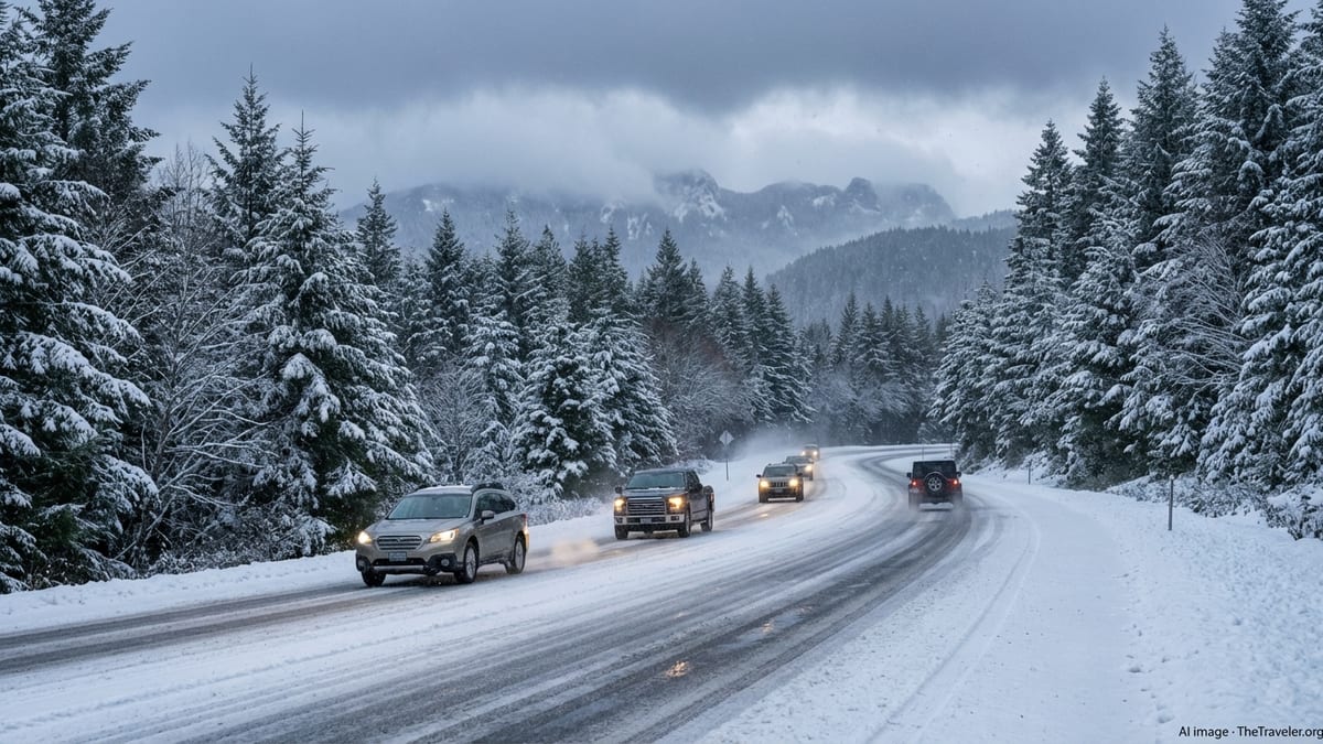
Travel Fears Mount on Key Highways and Mountain Passes
Transportation officials are warning that the timing and character of the storm could create a series of hazardous travel windows across northern Oregon’s main routes, particularly on mountain highways that funnel traffic between the Willamette Valley, the coast and Central Oregon.
In its most recent advisory, the Portland office of the National Weather Service cautioned that snow accumulations will be most impactful on the higher stretches of the North Oregon Coast Range and Cascade foothills, where roads such as state highways over Wilson River Summit, Sunset Summit and Marys Peak can quickly transition from bare pavement to snowpacked and slick conditions.
Farther south, Medford-based forecasters have highlighted portions of Interstate 5 and several state highways as particular trouble spots. Segments of I-5 near passes around 2,000 feet, along with highways 140, 238, 62 and 234, are expected to see periods of heavy snow, reduced visibility and ice that could make travel “very difficult to impossible” at times. Winter storm warnings above 2,000 feet in Jackson and Douglas counties call for 4 to 12 inches of snow, with localized higher totals in favored terrain.
With the storm coinciding with the tail end of Presidents Day holiday travel, officials stress that those who still need to return home or head out for work should consider adjusting their schedules to avoid the worst of the weather. The National Weather Service has repeatedly urged drivers to delay nonessential trips, carry emergency supplies, and be prepared for sudden closures or long delays, particularly overnight and during the Tuesday and Wednesday commute periods.
Communities Brace for Disruption and Power Concerns
Small towns scattered across the Coast Range and Cascade foothills are preparing for the possibility that this week’s storm will disrupt daily life well beyond the roadway network. Local emergency managers are warning residents that the combination of wet, accumulating snow and gusty winds at higher elevations could stress trees and power lines, leading to scattered outages.
From Detroit and Mill City along the Santiam corridor to Oakridge and McKenzie Bridge in Lane County, officials are urging households to stock up on basic supplies and ensure they have a way to stay warm if power fails. Fire departments and volunteer search and rescue teams in several counties have activated winter response plans, checking equipment and coordinating with utility crews in case conditions deteriorate overnight.
In the Rogue Valley and central Douglas County, where a companion winter storm warning covers higher ridges and a winter weather advisory spans lower valley communities, authorities are also watching for potential impacts to vulnerable residents. Cold nighttime temperatures, combined with wind and wet snow, could make outdoor exposure especially risky for people without reliable shelter or heating.
Health officials and social service agencies across the region are using social media and local radio to remind residents to check on neighbors, particularly older adults and those living alone in rural areas. Some jurisdictions are also preparing to extend the hours of warming centers if forecasts for a prolonged cold snap hold through Thursday.
Storm Dynamics: Cold Front and Cascade Snow Machine
Meteorologists describe the developing pattern as a classic midwinter setup for Oregon, featuring a sharp cold front followed by a persistent feed of moisture over a cold air mass. As frigid air spills south from the Gulf of Alaska, snow levels drop quickly, undercutting incoming Pacific moisture and turning what might otherwise be rain into snow over a wide elevation band.
Forecast discussions from the Medford and Portland weather offices emphasize that this is not a single, fast-moving storm but rather a sequence of disturbances embedded in a larger trough. The first punch arrives as the cold front sweeps inland, bringing a transition from rain to snow in the mountains late Monday into early Tuesday. Behind it, colder air lingers while several additional waves of showers roll through, each capable of dumping quick bursts of snow, especially during the overnight and early morning hours.
Forecasters say that this pattern is the reason for the unusually long lead times on the warnings and advisories, many of which remain in effect through Thursday morning. Even as accumulations taper off temporarily in some areas, another band of showers can rapidly rebuild snowpack on previously plowed roads or create fresh slick spots in the early commute window.
Regionally, the Oregon event is part of a wider western storm complex affecting Northern California, the Sierra Nevada and parts of Nevada and Colorado, where totals of several feet of snow and strong winds are also in play. For drivers and airlines operating interstate routes, that means the disruptions in Oregon are intertwined with a larger web of weather-related delays across the West.
Holiday Travel and Tourism Plans Thrown Into Turmoil
The timing of the storm is particularly unwelcome for the tourism sector, arriving as travelers attempt to wrap up Presidents Day weekend trips. Ski areas and mountain lodging operators in the Cascades typically welcome fresh snow, but rapid accumulations on access roads and the threat of whiteout conditions can quickly shift from boon to burden.
In northern Oregon, travel-related businesses are already fielding calls from concerned guests debating whether to depart early or risk driving during the most intense phases of the storm. Some hotels in the Santiam and Willamette Pass corridors have relaxed cancellation policies, encouraging guests not to take unnecessary chances on treacherous roads.
Regional airports in Eugene, Medford and the Portland metropolitan area are monitoring the situation closely as airlines weigh whether to adjust schedules or preemptively cancel or consolidate flights. While major terminals sit at relatively low elevations and are more likely to see rain or mixed precipitation, disruptions at larger western hubs hit by the same storm system could cascade into delays for Oregon-bound passengers throughout the week.
Outdoor recreation plans are also in flux. Trailheads, sno-parks and mountain recreation areas may receive significant new snow, but avalanche danger and poor visibility in higher backcountry terrain remain a concern. Search and rescue groups caution that even experienced winter travelers should think twice before venturing into remote areas during a complex, evolving storm cycle.
State and Local Agencies Ramp Up Winter Response
Oregon’s transportation and emergency management agencies are mobilizing resources as the storm bears down, with crews on extended shifts to keep priority routes as safe as possible. Plow operators across affected counties are preparing for repeated passes on key corridors, focusing first on interstates, major freight routes and emergency access roads to hospitals and critical facilities.
Deicing operations began ahead of the cold front on higher elevation segments, with crews spreading sand and anti-icing agents on bridges, overpasses and steep grades that are prone to rapid icing when temperatures fall. Officials caution, however, that in the heaviest bursts of snow and on the steepest passes, even well-treated roads can quickly become snow-covered and hazardous.
County sheriffs and state police have warned that they may temporarily close particularly dangerous sections of highway if conditions deteriorate beyond what plows and chains can manage. Drivers are being told to expect chain requirements at many mountain passes and to carry traction devices even if forecasts at lower elevations still call for rain.
Local school districts and government offices throughout the Coast Range and Cascade foothill communities are also watching forecasts for potential schedule changes. Some have already announced that they will make early-morning decisions about closures or delays depending on overnight snowfall and road reports from transportation crews.
Safety Guidance for Residents and Travelers
With the National Weather Service explicitly warning that travel could be very difficult to impossible at times, safety agencies are repeating a familiar set of winter storm messages, tailored to the specifics of this multi-day event. The first, and most consistent, piece of advice is straightforward: if you do not have to travel during the height of the storm, stay home and stay off the roads.
For those who must drive, officials recommend slowing down, increasing following distance and keeping an emergency kit in the vehicle, including warm clothing or blankets, water, food, a flashlight and a fully charged phone. Motorists are also urged to ensure they have a full tank of fuel, properly mounted winter tires or chains, and a clear understanding of their planned route, including alternate options if a pass closes unexpectedly.
Homeowners in the most snow-prone areas are being encouraged to move vehicles off narrow streets where possible to help snowplows operate more efficiently, and to keep sidewalks and steps clear of snow and ice to prevent falls. Those relying on medical equipment or refrigerated medications are advised to think ahead about how they would cope with a power outage, whether through backup batteries, generators or temporary relocation with family or friends.
Emergency responders stress that winter storms of this type are often more dangerous after the first wave of snowfall, when complacency sets in and drivers underestimate lingering slick spots, black ice and reduced visibility. With additional snow showers and cold air expected to linger into Thursday, they say, caution will need to extend well beyond the initial headlines of the storm.