
More news on this day
A powerful late-winter storm system sweeping from the Midwest toward the East Coast has upended air travel across the United States, with thousands of flights canceled or delayed as snow, ice and high winds batter major hubs at one of the busiest times of the spring travel season.
Get the latest news straight to your inbox!
Storm Tracks From Midwest to East Coast, Hitting Key Hubs
The current storm complex, developing over the central United States at the end of the week of March 13 and intensifying through March 17, is bringing a mix of heavy snow, freezing rain and severe winds to a broad swath of the country. Meteorological summaries describe a large extratropical system with blizzard conditions across parts of the Upper Midwest, an ice storm over sections of the Great Lakes, and damaging winds reaching into the Mid Atlantic and Northeast.
As the system moved east, snow and blowing snow reduced visibility at major Midwest airports serving Chicago, Minneapolis and Detroit, while ice and strong crosswinds created difficult operating conditions for carriers and airport crews. Public reporting indicates that hubs in New York, Boston, Atlanta and other busy East Coast and Southeast airports are now experiencing the brunt of wind and thunderstorm impacts linked to the same weather pattern.
Weather agencies have highlighted gusts near or above 50 miles per hour in portions of the Northeast and mid-Atlantic, a threshold that can quickly force changes to runway configurations and limit the rate at which aircraft can safely depart and arrive. Combined with snow-packed or slushy surfaces at some northern fields, these conditions have translated into rapid slowdowns in airport operations across several regions.
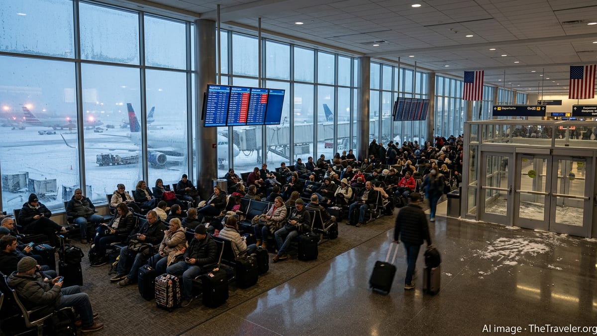
Thousands of Flights Canceled and Delayed Nationwide
Flight-tracking data and published coverage show large-scale disruption to domestic air schedules as the storm progresses. Airlines have proactively scrubbed hundreds of flights from their networks, particularly at hubs in the Upper Midwest where blizzard warnings and low visibility make safe operations difficult. At the same time, rolling delays are mounting at East Coast gateways as wind, rain and lingering snow bands move through major metropolitan areas.
Recent tallies from national outlets indicate that, over the past 48 hours, several thousand flights have been canceled or delayed across the United States, with numbers continuing to fluctuate as conditions shift. Chicago O’Hare, one of the country’s primary connecting hubs, has seen some of the heaviest disruption, while other key nodes in New York, Atlanta and the Washington region are also reporting elevated delays as the storm pushes east.
The timing adds extra strain to the system. The mid-March period brings a surge of spring break travelers and college basketball fans heading to early rounds of national tournaments, pushing passenger volumes higher than typical winter weekdays. With aircraft already heavily booked, even a moderate schedule reduction can leave few options for same-day rebooking, extending the practical impact of each cancellation.
Why Snow, Ice and Wind Paralyze Airport Operations
Winter storms disrupt flying not just because of what happens in the air but also due to the complex chain of ground operations that must align for each departure. When heavy snow falls, airport crews must repeatedly plow runways, taxiways and ramp areas to keep surfaces safe, a process that can temporarily close runways or limit movements while equipment is on the field. Accumulating snow also requires aircraft de-icing, which adds extra time to each departure and can quickly create long queues.
Ice is a particular concern for both safety and efficiency. Even thin layers of freezing rain or sleet can make runways and taxiways dangerously slick, while also building up on aircraft surfaces. That forces airlines to slow or suspend operations until temperatures rise or treatment has time to take effect. In some cases, airports impose reduced arrival and departure rates because braking performance data and wind conditions no longer support normal traffic levels.
High winds compound these challenges. Strong crosswinds can limit the runways available for use and, at certain thresholds, make landings and takeoffs unsafe for specific aircraft types. Gusty conditions also cause knock-on effects around the airport, from difficulty moving ground equipment to temporary halts in ramp work when lightning or severe turbulence is in the area. Together, these factors turn a dynamic weather event into a prolonged operational tangle, even after the heaviest precipitation moves away.
Where Travelers Are Feeling the Biggest Impact
The worst disruptions are currently centered on major connecting hubs in the Midwest and Northeast, where the storm’s snow and wind have coincided with dense banked schedules. Chicago O’Hare and Chicago Midway have both seen waves of cancellations and extended delays, while Minneapolis and Detroit have also experienced significant schedule changes as blizzard and ice conditions pass through the region.
Farther east, the combination of high winds, low ceilings and fast-moving rain and snow showers is affecting New York area airports, Boston and other New England and Mid Atlantic gateways. Reports describe ground delay programs and occasional ground stops imposed to manage arrival flows when visibility drops or wind shifts limit runway choices. These constraints not only affect local travelers but also ripple through connecting itineraries across the country.
The storm’s southern flank is producing strong thunderstorms and turbulence in parts of the Southeast, including airspace feeding Atlanta, one of the world’s busiest airports. Even when conditions at a given airport are VFR, en route weather along major jet corridors can require reroutes, increased spacing between aircraft or temporary flow restrictions, all of which result in longer flight times and potential missed connections.
What Passengers Can Do If Their Flight Is Affected
For travelers caught in the current wave of disruptions, the best immediate step is to monitor flight status directly through airline channels rather than relying on static confirmation emails or third-party booking sites. Carriers often issue weather waivers in advance of major storms, allowing customers to change travel dates or routes without standard change fees, subject to seat availability and fare rules.
Industry guidance suggests that passengers whose trips are not time-sensitive consider rescheduling to later in the week, when forecasts show the system moving away from the East Coast and operations gradually normalizing. Those who must travel during the peak of the storm should plan for extended days, allow additional time at the airport in case of security or rebooking lines, and be prepared for short-notice gate changes or equipment swaps.
Because hotel rooms near major airports can fill quickly during large disruption events, travelers facing overnight delays may wish to secure accommodation early once it becomes clear that same-day travel is unlikely. Packing essential medications, chargers and basic toiletries in carry-on luggage rather than checked bags can also make unplanned layovers more manageable when baggage access is limited.
While the present storm is expected to move off the East Coast within the next day, the volume of displaced passengers and aircraft means residual delays and cancellations may persist beyond the immediate weather window. For anyone flying through affected hubs this week, keeping a flexible mindset and closely following real-time airline updates will be key to navigating a challenging stretch of late-season winter weather.