
More news on this day
A powerful late-winter nor’easter is bearing down on the U.S. East Coast this weekend, threatening to bury iconic cities from Washington to Boston in deep snow, whip coastal communities with fierce winds and leave millions of travelers stranded on the ground as blizzard conditions close airports, snarl highways and disrupt rail lines at the height of the winter getaway season.
Blizzard Warnings Blanket the East Coast Corridor
From New York City to coastal New Jersey, Delaware and southern New England, blizzard warnings have been hoisted as forecasters warn that this storm could be one of the most disruptive snow events to hit the Interstate 95 corridor in years. The National Weather Service has upgraded several areas from winter storm watches to full blizzard warnings as confidence has grown that snow, wind and whiteout conditions will combine to make travel extremely dangerous or outright impossible for long stretches of Sunday night into Monday.
Current projections call for widespread totals of 12 to 24 inches of heavy, wet snow in the hardest-hit zones, with the bull’s-eye running from the mid-Atlantic coast through New York City, Long Island, coastal Connecticut, Rhode Island and parts of eastern Massachusetts. Localized bands could deliver snowfall rates of 1 to 2 inches per hour, quickly overwhelming plows and turning even major highways into impassable ribbons of white.
Inland metropolitan areas such as Philadelphia, New York and Boston are bracing for at least 8 to 16 inches, with some forecasts nudging totals higher where colder air locks in more quickly. Closer to the shoreline, the exact track of the low-pressure system will determine whether early rain flips to snow in time to match inland accumulations, but forecasters caution that the combination of strong winds and moderate snow may still meet blizzard criteria in these densely populated, travel-dependent coastal belts.
Complicating the picture is the storm’s timing. Snow is expected to ramp up through Sunday afternoon, with the worst conditions from late Sunday evening into Monday morning. That window coincides with peak road and air travel, school commutes and business openings, raising the risk of widespread closures, last-minute cancellations and cascading delays that could ripple through national travel networks well beyond the East Coast.
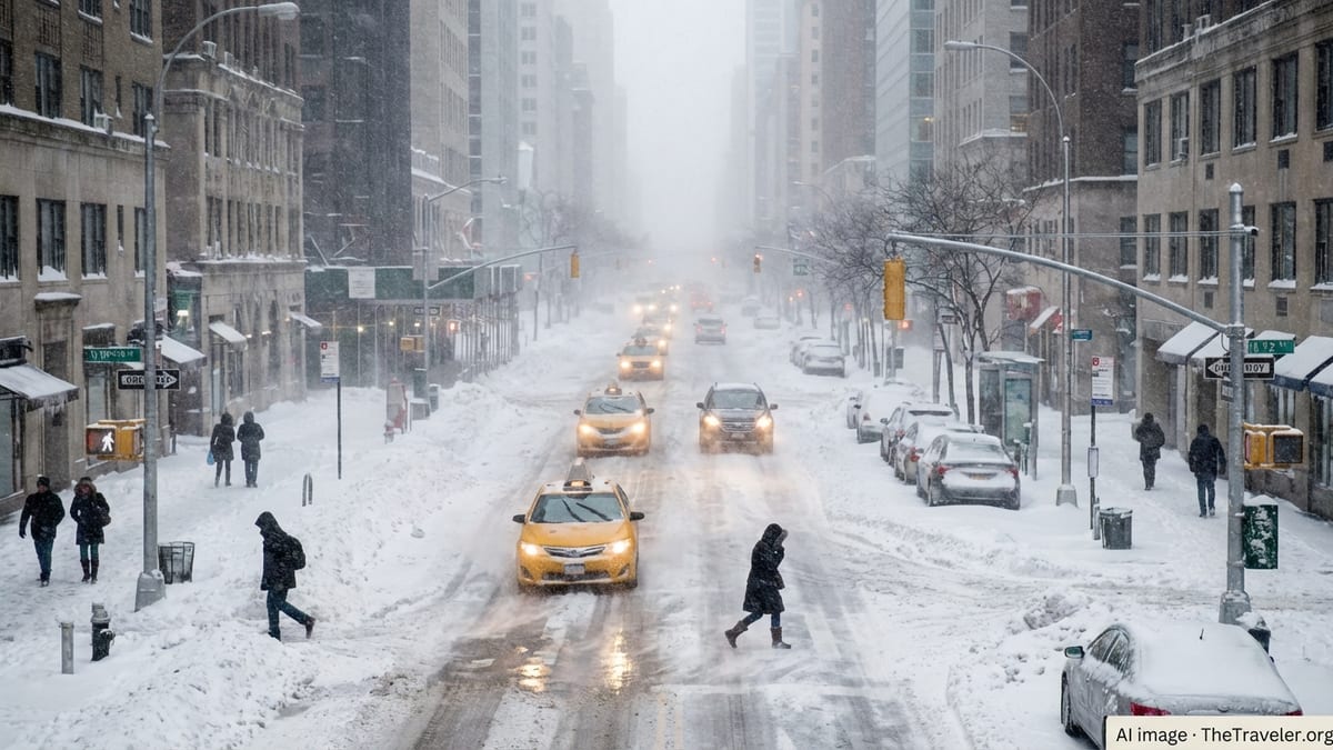
Iconic Cities Brace for a Whiteout Weekend
In New York City, where a blizzard warning has been issued for the first time in nearly a decade, memories of past paralyzing storms are driving an aggressive preemptive response. Sanitation crews have been prepositioning salt spreaders and plows in all five boroughs, while officials warn residents that the city’s famed round-the-clock transit culture will not be immune if visibility collapses and snow piles up faster than crews can clear it.
Times Square, Midtown Manhattan and the Brooklyn waterfront are all expected to see significant accumulations, with wind gusts that could topple tree limbs and power lines, particularly in parks and older neighborhoods. On Long Island, where the heaviest snow bands are projected to come ashore, local authorities are urging coastal communities to prepare for both drifting snow and pockets of coastal flooding as strong onshore winds push water into bays and inlets at high tide.
Farther south, Philadelphia is under a winter storm warning with a realistic chance of recording more than a foot of snow, potentially doubling the totals from a major storm that hit in late January. Blizzard conditions are more likely along the nearby Jersey Shore, where a mix of heavy snow, powerful gusts and coastal flooding could once again bring boardwalk resorts and barrier islands to an eerie standstill at what is usually a quiet but still active shoulder season for regional tourism.
Boston and other New England hubs are expected to feel the storm’s full force a bit later in the cycle, as the nor’easter intensifies off the coast and curls northward. Forecasts call for double-digit snowfall totals across much of eastern Massachusetts and coastal New Hampshire, with localized drifts several feet high where winds sculpt the deep powder into waves across city streets and commuter rail lines. For travelers angling for winter escapes or late-season city breaks, the storm threatens to turn dream itineraries into snowbound layovers.
Air Travel Turmoil From Washington to Boston
Airlines and airport authorities across the East Coast are preparing for a brutal operational stretch, drawing lessons from the historic late-January winter storm that forced the cancellation of more than ten thousand flights nationwide and temporarily shut down key hubs. With the new blizzard set to hit many of the same airports, carriers have already begun issuing waivers that allow customers to rebook without change fees and urging passengers with flexible schedules to shift travel outside the Sunday to Monday window.
Major hubs including New York’s John F. Kennedy International, LaGuardia, Newark Liberty, Philadelphia International, Boston Logan and Washington’s Reagan National and Dulles airports are all in the storm’s projected impact zone. Even before the first flakes fly, travelers should expect a rising wave of preemptive cancellations as airlines consolidate schedules to avoid stranding aircraft and crews in the teeth of the nor’easter.
Industry analysts warn that the geography of this storm makes it particularly disruptive. The I-95 corridor is not only a densely populated region but also the backbone of the U.S. domestic air network, with countless connecting flights passing through East Coast hubs on their way to destinations across the country and overseas. When winter weather closes those gateways, ripple effects can spread as far as the West Coast and Europe, leaving travelers stranded thousands of miles from the snowbound runways causing the disruption.
Airport operators, still mindful of the January cancellation crisis, are pre-treating runways, staffing up de-icing teams and preparing emergency accommodations for passengers who may be caught mid-journey when conditions deteriorate. Nonetheless, forecasters’ warnings of whiteout visibility and wind gusts approaching or exceeding 35 miles per hour suggest that safety constraints will leave air traffic controllers with little choice but to halt or heavily restrict operations during the worst of the storm.
Highways, Rail Lines and Local Transit Under Strain
The nation’s most heavily traveled highway corridor, stretching along I-95 from Virginia through Maine, is bracing for a dangerous mix of heavy snow, blowing drifts and flash-freezing that could turn busy interstates into treacherous ribbons of ice. Transportation departments in multiple states have issued early warnings urging drivers to avoid nonessential travel from late Sunday through at least Monday midday, and to expect closures on key bridges, tunnels and elevated roadways if conditions deteriorate faster than expected.
State and local plow fleets are already on heightened alert, with road salt stockpiles replenished after the January storms that swept across much of the country. Yet the forecast of rapid-fire snowfall rates, especially overnight, raises concerns that even major arterials may become impassable for several hours. Officials warn that abandoned vehicles could compound the danger by blocking plows and emergency responders from reaching trouble spots, a scenario that has played out in past East Coast blizzards.
Intercity rail service is also at risk. Amtrak has signaled that schedules on the busy Northeast Corridor between Washington, New York and Boston may be reduced or suspended as the storm peaks, particularly on sections of track vulnerable to drifting snow and overhead power line damage. Regional rail networks around New York, Philadelphia and Boston are preparing contingency timetables, with crews inspecting switches, clearing drainage channels and readying standby teams to respond if frozen equipment or downed trees interrupt service.
Urban transit systems from Washington’s Metro to New York’s subway and Boston’s T service are under pressure to balance safety with the need to keep essential workers, including medical staff and first responders, moving during the storm. While subway lines running underground are less vulnerable to snow than buses or aboveground commuter trains, transit authorities stress that severe power outages, street flooding or police closures can still force sudden suspensions and route changes.
Communities Still Recovering From a Punishing Winter
The looming blizzard comes on the heels of a punishing stretch of winter weather that has already tested communities and infrastructure across the United States. A deadly late-January storm system dumped 1 to 2 feet of snow from Texas to Maine, triggered massive power outages in the South and produced one of the worst days for flight cancellations since the early days of the pandemic. In the Southeast, a separate bomb cyclone brought hurricane-force winds, heavy precipitation and further disruptions to travel and power networks.
In the Upper Midwest, residents are only just emerging from a February storm that closed stretches of highway, shut down segments of Minnesota’s scenic North Shore and left travel nearly impossible across exposed rural areas. That system is now feeding cold air into the developing coastal low, setting the stage for the nor’easter to strengthen rapidly as it slides up the Atlantic seaboard.
For East Coast cities, the new storm threatens to erase the modest thaw that followed January’s ferocious weather. Piles of old snow that had finally begun to melt in New York, Philadelphia and Boston are likely to be buried under a fresh, much deeper blanket, complicating snow removal and narrowing already congested streets. Municipal budgets, already strained by back-to-back plowing and salting operations, may come under further pressure if this storm delivers the high-end snowfall totals now on the forecast maps.
Residents in hard-hit regions report a sense of winter fatigue as they brace for yet another round of closures, remote work days and childcare juggling. Yet local officials emphasize that prior storms have at least given them a recent stress test of their emergency plans, helping to fine-tune communication channels, staging areas and mutual-aid arrangements between neighboring jurisdictions ahead of this latest blow.
What Travelers Need to Know Right Now
For travelers with plans anywhere along the East Coast over the next several days, experts say the most important step is to act early. Airlines are encouraging customers booked on flights into or out of affected airports to check their carrier’s weather waiver policies and move trips before or after the storm whenever possible. Rebooking before widespread cancellations hit usually yields more options and better itineraries than waiting until aircraft and crew rotations have been thrown into disarray.
Those who must travel by air during the storm window are urged to pack medications, chargers, snacks and a change of clothes in carry-on luggage in case an unexpected overnight stay becomes necessary. With hotel rooms near major airports likely to fill up quickly, having a backup plan with friends, family or alternative transportation options could prove crucial if flights are scrubbed at the last minute.
On the road, officials stress that the safest choice during a blizzard is to avoid driving altogether. If travel cannot be postponed, motorists are advised to fully fuel their vehicles, carry winter emergency kits including blankets, water, nonperishable food and a shovel, and keep phones charged for potential emergency calls. Planning routes that favor major highways, where plowing resources are concentrated, can also improve the chances of reaching a destination safely before conditions deteriorate.
Rail passengers should monitor service alerts closely and be prepared for reduced timetables or suspended segments, especially on lines that cross open country or coastal stretches prone to drifting snow and high winds. Flexible tickets, travel insurance that covers weather disruptions and a willingness to adjust itineraries on short notice will be assets across all modes of transport as the storm unfolds.
How This Blizzard Fits a Changing Winter Travel Reality
While individual storms are driven by day-to-day weather patterns, the drumbeat of high-impact winter events across different parts of the United States this season is forcing travelers, airlines and destination managers to rethink their assumptions about cold-season reliability. From the deadly January cross-country storm to the Upper Midwest’s recent whiteouts and now the looming East Coast blizzard, winter has repeatedly shown its ability to upend even the most carefully laid travel plans.
Tourism officials in major East Coast cities say they are increasingly building flexibility into winter marketing campaigns, highlighting not only traditional attractions but also cold-weather experiences that can continue even when snow falls. Museums, indoor cultural venues and neighborhood restaurants often remain open, and some hotels now offer snowstorm packages that turn forced stays into mini-retreats, complete with late checkouts and bundled meals when streets outside are impassable.
At the same time, the growing sophistication of weather models is giving airlines and rail operators a longer lead time to adjust schedules, reposition equipment and communicate with customers before storms strike. That proactive approach cannot eliminate disruption, but it can reduce the chaos that once characterized major winter events, turning some potential crises into managed slowdowns that travelers can better navigate with accurate, timely information.
For now, though, the priority across the East Coast is clear: getting through the next 48 hours safely. As another powerful storm closes in on some of the nation’s most iconic cities and busiest travel corridors, residents and visitors alike are racing to adapt, reschedule and hunker down, waiting to see just how deep this latest blanket of snow will be and how long it will keep the region’s winter dreams on hold.