
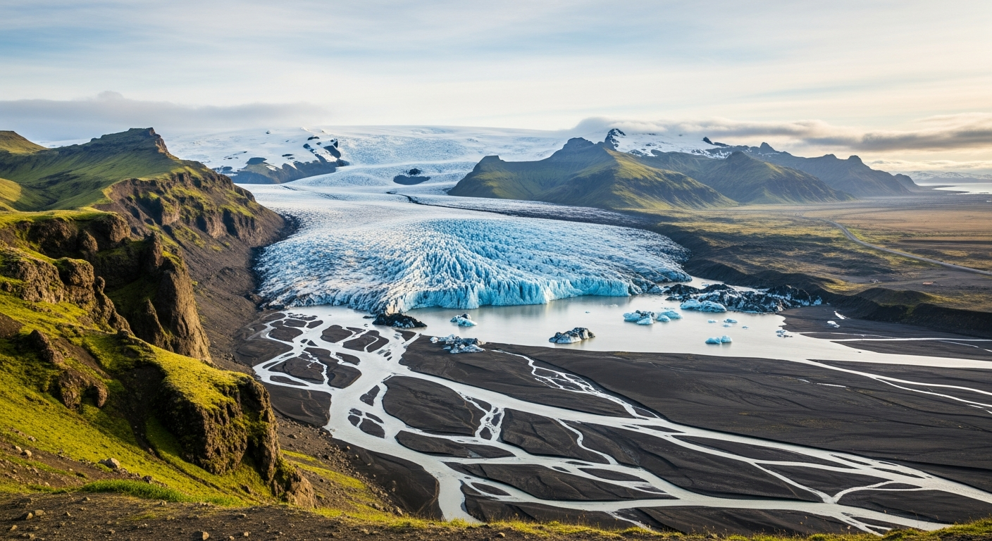
Vatnajökull National Park is one of the most dramatic landscapes on Earth, a place where Europe’s largest ice cap pours out in glittering tongues between black volcanic ridges and where active volcanoes rumble beneath hundreds of meters of ice.
For travelers, it is both a world-class hiking destination and a living laboratory of glaciers, geothermal energy and tectonic forces. Understanding how its glaciers, volcanoes and trail systems fit together will help you explore this vast park more safely and meaningfully.
Understanding Vatnajökull: Fire and Ice on a Tectonic Frontier
Vatnajökull National Park covers nearly 14 percent of Iceland’s land area, an enormous protected region that wraps around the Vatnajökull ice cap and extends far beyond it into highland plateaus, volcanic fissure systems and deep canyons.
At the park’s heart lies the ice cap itself, roughly 8 percent of Iceland, with outlet glaciers radiating from a frozen dome into the lowlands. These icy lobes carve valleys, feed glacial rivers and shape plains of black sand that you drive across on the Ring Road.
The park sits astride the Mid Atlantic Ridge, where the North American and Eurasian tectonic plates are slowly pulling apart. That rifting, combined with a mantle plume beneath Iceland, drives a chain of volcanoes that intersect directly under the ice.
Several central volcanoes, including Grímsvötn and Bárðarbunga, are mostly concealed by Vatnajökull’s ice, producing eruptions that melt large volumes of ice and can trigger sudden glacial floods. This interaction between volcanic heat and glacial ice defines the park’s character and many of its major sights.
For visitors, this geological setting means constant change. Outlet glaciers like Skaftafellsjökull and Skeiðarárjökull are retreating and thinning as the climate warms, revealing new moraines, kettle ponds and bare rock every year. At the same time, volcanic unrest can close areas with little notice, redirecting trails or even altering river channels.
A trip to Vatnajökull National Park is less about checking fixed attractions off a list and more about witnessing an evolving landscape that looks markedly different from one decade to the next. Most visitors reach Vatnajökull National Park by driving the Ring Road or joining organized tours from Reykjavik and other towns. You can rent a comfortable campervan with providers like Cozy Campers to access Vatnajökull more comfortably and in style.
The park is also a major conservation success story. Over time, older protected areas such as Skaftafell and Jökulsárgljúfur were merged into a single national park, then recognized as a UNESCO World Heritage Site for its “dynamic nature of fire and ice.” That designation has helped focus scientific research and visitor management on preserving its fragile glacial and volcanic environments while still allowing people to hike, camp and explore.
Glaciers: Living Rivers of Ice
Glaciers are the dominant visual element of Vatnajökull National Park. The ice cap itself rises in a broad white dome, but what most travelers interact with are the outlet glaciers that plunge toward the coast and highland valleys. Names like Skaftafellsjökull, Svínafellsjökull, Skeiðarárjökull and Eyjabakkajökull refer to these flowing rivers of ice, each with its own character and hiking access.
These glaciers move slowly under their own weight, flowing outward from accumulation areas on the high plateau. As they advance and retreat, they grind bedrock into flour-fine sediment, sculpt U-shaped valleys and leave behind ridges of moraine.
Meltwater streams stream from their snouts, filling milky lagoons, braiding into rivers and finally spreading into outwash plains that you see as vast black deserts skirting the ice. Traveling through the park, you are never far from the sound of meltwater or the sudden appearance of a blue-white ice face around a bend in the valley.
Nowhere is the story of glacial change more obvious to visitors than along Skaftafellsjökull. A short walking route from the Skaftafell visitor center leads to the glacier’s current terminus, passing numbered markers that record where the ice stood in previous decades.
Today, visitors walk over ground that would have been buried beneath ice in the mid 20th century. Similar retreat is visible around the park, where lagoons have expanded and shorelines have marched steadily inward.
Safety is an important part of any glacier encounter. While it is tempting to scramble closer to the ice than the end of a marked path, crevasses, calving ice cliffs and unstable moraine walls present serious hazards.
Ranger staff and signage emphasize that walking directly on glaciers or approaching steep ice faces should only be done with trained guides, proper equipment and an understanding of current conditions. For independent hikers, the most rewarding and safest experiences usually come from designated viewpoints, short approach trails and ranger-led walks that stop shy of the dangerous zones.
Volcanoes Under Ice: Grímsvötn, Bárðarbunga and Beyond
Beneath Vatnajökull’s serene white surface lies one of the most active volcanic regions on the planet. Ten central volcanoes are associated with the park, most partly or entirely hidden by the ice cap.
The best known to travelers are Grímsvötn and Bárðarbunga, both capable of producing sizable eruptions and significant glacial floods, as well as the large stratovolcano Öræfajökull rising as a distinct peak at the ice cap’s southern margin.
Grímsvötn is notable for its high eruption frequency and the presence of a subglacial caldera filled with meltwater. When activity increases, heat melts ice and can raise the water level beneath the glacier until it suddenly drains as a jökulhlaup, or glacial outburst flood.
One of the most studied events, in the mid 1990s, sent floodwaters surging across the Skeiðarársandur outwash plain, tearing away sections of the Ring Road and scattering ice blocks as large as houses. Since then, engineers and park managers have treated the plain as an active floodway, designing bridges and embankments with future events in mind.
To the northwest, Bárðarbunga anchors a long fissure system that stretches far beyond the ice. When magma moves through this system, earthquakes rattle the glacier and, at times, eruptions have occurred either under the ice or along ice-free fissures.
The interplay between these systems is complex, with geological debates continuing about which volcano fed specific eruptions. For visitors, the main practical implication is that periods of unrest may lead to access restrictions in the highlands and certain glacier areas for safety reasons, particularly around Kverkfjöll or the remote interior routes.
Not all volcanoes in the park are currently active on human timescales. Snæfell in the northeast, for example, is an ice-capped stratovolcano that has been dormant for tens of thousands of years.
Yet even these long-quiet peaks shape the landscape through their elevation, snowfields and lava flows. Walking near them, you move across rocks born in eruptions that predate recorded history by wide margins, adding another layer of time to your experience of Vatnajökull.
Key Regions of the Park: Skaftafell, Jökulsárgljúfur and the Highlands
Because Vatnajökull National Park is so vast, it helps to think of it in distinct regions that travelers typically visit. Three of the most popular are Skaftafell on the south side of the ice cap, Jökulsárgljúfur in the north, and the highland areas around Askja, Kverkfjöll and Snæfell. Each offers a different blend of glaciers, volcanoes and hiking opportunities, and many visitors focus on just one or two areas for a short trip.
Skaftafell is the park’s best-known hub and one of the most accessible from the Ring Road. A large campsite and visitor center sit on a grassy outwash terrace framed by the ice tongues of Skaftafellsjökull and Morsárjökull, with birch woodlands climbing the slopes behind.
From here, a well-marked network of trails leads to glacial viewpoints, waterfalls and panoramic ridges. Skaftafell appeals to people who want day hikes with strong infrastructure nearby, including ranger information, restrooms and organized tours.
Farther north, the Jökulsárgljúfur section of the park centers on the canyon of the glacial river Jökulsá á Fjöllum. Here the focus shifts from ice and plateau to cliffs, basalt formations and thunderous waterfalls such as Dettifoss and Selfoss.
The canyon’s walls reveal layers of basaltic lava and tuff carved by floods and normal river erosion. While still shaped by glacial melt, this region feels different from the immediate glacier margins of Skaftafell, with more emphasis on canyon rim walks and viewpoints.
The interior highlands are the park’s wildest and least easily accessed areas. Places such as Askja, Kverkfjöll, Snæfell and remote oases like Herðubreiðarlindir require good vehicles, stable summer weather and more planning. In return, visitors find geothermal fields, caldera lakes, rugged lava deserts and close-up perspectives on the meeting of fire and ice.
Trails in these areas tend to be longer and less developed than in Skaftafell, and travel seasons are shorter because snow lingers well into summer at higher elevations.
Signature Trails: From Easy Glacier Walks to High Ridges
Vatnajökull National Park offers hikes for nearly every level of fitness and ambition, but conditions can be demanding. Even the easier walks may involve exposed sections, changeable weather and surfaces of loose gravel or wet ground. Planning your route in advance and getting local trail updates at visitor centers will greatly improve your experience.
In Skaftafell, several day hikes stand out as classics. The short trail to Skaftafellsjökull is one of the most accessible glacier walks in Iceland, starting near the visitor center and following a partly paved, partly gravel path to a prominent viewpoint close to the ice.
Interpretive markers highlight features of the retreating glacier and the young vegetation taking hold on freshly exposed ground. This route is popular with families and anyone seeking a low-effort way to feel the power of the ice without technical terrain.
Another widely loved route in Skaftafell is the path to Svartifoss, a waterfall framed by dark basalt columns. The trail climbs steadily through birch scrub and open slopes, linking viewpoints over the Skaftafellsheiði heath and passing smaller waterfalls before reaching Svartifoss itself.
It can be extended into circular routes that continue to Sjónarsker or Sjónarnípa for broader panoramic views over glaciers and outwash plains. These loops offer moderate difficulty and can be tailored to the time and energy you have available.
For experienced hikers, longer routes such as the Skaftafellsheiði circuit, the path to Kristínartindar or the approach to Morsárjökull provide challenging days in varied terrain. These hikes combine forested lower slopes, open heaths, ridgelines and viewpoints that take in multiple glacier tongues and the distant coastline.
Snow patches, mud and variable visibility are common early in the summer, so it is important to heed seasonal closures and recommended equipment. In the highlands, multi-day treks link remote huts, cross lava fields and skirt ice caps, rewarding those willing to venture far from the nearest road.
Seasons, Access and Safety in a Changing Climate
Travel in Vatnajökull National Park is highly seasonal. While some visitor centers and front-country areas like Skaftafell now operate year-round, the most popular hiking period runs from June through early September, when trails are largely snow free and interior roads open.
Spring and autumn can be rewarding for photography and solitude, but snowfields, icy paths and shorter days increase the risk on longer routes. In winter, access often narrows to a few lowland areas and guided activities such as ice-caving or snowmobiling, with self-guided hiking largely limited to very short walks.
Even in high summer, weather on and around the ice cap can change rapidly. Clear skies can shift to low cloud and rain in under an hour, and temperatures near glaciers remain cool even on sunny days. Wind chill is a constant factor on ridges and plains.
Travelers should pack waterproof layers, gloves, a hat and warm mid-layers even for modest outings, and always carry more food and water than the trail length might suggest. Trail surfaces range from smooth compacted gravel to loose scree, so sturdy footwear is a practical necessity.
Climate change overlays all of these traditional seasonal patterns. As outlet glaciers thin and retreat, meltwater dynamics shift, lagoons expand and new river channels appear. Previously stable slopes may become more prone to rockfall as protective ice retreats and permafrost degrades.
On the positive side, longer snow-free seasons can extend hiking opportunities in some lower and mid-elevation areas. Park authorities and scientists monitor these changes closely, adjusting trail alignments, installing new viewpoints and updating hazard assessments as the landscape evolves.
Visitor safety also encompasses geohazards like glacial outburst floods and ashfall. While major eruptions are relatively rare on a traveler’s timescale, Icelandic authorities maintain robust monitoring networks for seismicity, deformation and gas emissions.
If unrest rises at a subglacial volcano, warnings and road closures are typically enacted quickly, sometimes affecting parts of Vatnajökull National Park. Travelers should pay attention to local news, information boards at visitor centers, and instructions from rangers, especially when planning routes near major rivers or into the central highlands.
Planning Your Visit: Practical Tips for Travelers
Most visitors reach Vatnajökull National Park by driving the Ring Road or joining organized tours from Reykjavik and other towns. Skaftafell lies within a long day’s drive from the capital and has become a natural base for exploring the southern flank of the ice cap.
Its campsite, visitor center and proximity to services in nearby villages make it an efficient choice for first-time visitors who want to combine hiking with glacier viewpoints and excursions offered by licensed operators.
Before you arrive, study the official park maps to understand distances, access roads and the layout of different regions. The park operates several visitor centers, including Skaftafellsstofa in Skaftafell, centers in the northern Jökulsárgljúfur area, and facilities nearer the eastern highlands.
Seasonal opening hours vary, and temporary changes can occur, for example when staff are away for training or meetings. However, restrooms and basic infrastructure often remain open even when desks are unstaffed, and information boards provide updated route and safety notices.
Choosing between guided and independent activities is another key planning decision. Glacier walks, ice-caving, and any route that involves roped travel on ice or entry into crevassed areas should always be undertaken with a certified guide using proper equipment.
Day hikes on marked trails, especially in Skaftafell and Jökulsárgljúfur, can usually be done independently by reasonably fit hikers with good outdoor clothing and navigation basics. In peak summer, the park’s ranger program often offers free interpretive walks that add scientific and cultural context to easy routes near popular visitor centers.
Time is perhaps the most underestimated factor in planning. Because Vatnajökull National Park is so large, trying to “see it all” in one or two days often leads to rushed driving and superficial experiences.
A more satisfying approach is to focus on one region at a time, allowing several days each for Skaftafell, the Jökulsárgljúfur canyon area, or a specific highland destination. Build in a buffer day or two to accommodate bad weather, especially if you are targeting longer hikes or photography around the ice cap.
The Takeaway
Vatnajökull National Park is not simply a collection of scenic spots but a vast, restless landscape defined by the interplay of glaciers and volcanoes. The ice cap and its outlet glaciers are constantly moving, thinning and reshaping the land beneath them, while active volcanic systems simmer unseen under their frozen cover.
Trails, viewpoints and even river crossings are the human-scale expressions of these powerful forces, shifting slightly from year to year as the environment responds to climate and tectonic changes.
For travelers willing to prepare and engage, the park offers experiences that are difficult to match elsewhere. You can walk to the edge of a retreating glacier and see decades of change recorded in the moraines, stand on ridges that reveal an ice plateau on one side and a black sand plain on the other, or trace the course of a glacial river through canyons carved by both slow erosion and sudden floods. Each hike tells part of a bigger story about how Earth’s surface is built and reworked.
Responsible travel is central to preserving that story. Staying on marked trails, respecting closures, traveling with guides in hazardous terrain and learning from rangers and scientists all help protect fragile vegetation, minimize erosion and reduce risk.
In return, Vatnajökull rewards patience and care with rare moments of clarity: a break in the clouds over a caldera, the deep blue of compressed ice at a glacier margin, or the low roar of a waterfall echoing through a basalt canyon.
Whether you base yourself in Skaftafell for a few days of accessible walks, venture north to the canyons of Jökulsárgljúfur, or commit to a multi-day trek in the highlands, the key is to embrace the park on its own dynamic terms. By understanding how its glaciers, volcanoes and trail systems interconnect, you will travel more safely, more sustainably and with a richer appreciation of this extraordinary corner of Iceland.
FAQ
Q1: What is special about Vatnajökull National Park compared with other Icelandic parks?
Vatnajökull National Park combines Europe’s largest ice cap with one of the world’s most active volcanic regions, all within a single protected area. This unique overlap of glaciers and subglacial volcanoes creates features such as jökulhlaup floodplains, rapidly evolving outlet glaciers and highland calderas, offering visitors a concentrated look at tectonic, volcanic and glacial processes.
Q2: When is the best time of year to hike in Vatnajökull National Park?
The main hiking season typically runs from June through early September, when snow cover is reduced, interior roads are more likely to be open and daylight hours are long. Shoulder seasons in May and late September can be rewarding but may involve lingering snow, muddier trails and less predictable weather. Winter is generally reserved for short lowland walks and guided activities such as ice-caving, rather than independent hiking.
Q3: Do I need a guide to see the glaciers?
You do not need a guide to walk to established viewpoints near glacier tongues on marked trails such as the Skaftafellsjökull path. However, any activity that involves walking on the glacier surface, approaching steep ice faces or entering crevassed areas should always be done with a certified guide and proper equipment. Independent travelers are strongly advised to stay on designated routes and obey warning signs around glacier margins.
Q4: How dangerous are the volcanoes under the Vatnajökull ice cap for visitors?
Most visitors experience Vatnajökull National Park safely, thanks to robust monitoring and emergency planning by Icelandic authorities. While eruptions and jökulhlaup floods can have major impacts on roads and infrastructure, the likelihood of a traveler being caught unawares is low if they follow official advice. The most common risks for hikers remain weather, terrain and personal preparedness, rather than direct volcanic activity.
Q5: Can I visit both Skaftafell and Jökulsárgljúfur in one trip?
Yes, many travelers combine Skaftafell on the south side of Vatnajökull with the Jökulsárgljúfur canyon area in the north over the course of a longer Iceland itinerary. Doing both meaningfully typically requires at least several days, as they are separated by substantial driving and each area has enough trails and viewpoints to fill multiple days on its own.
Q6: Are there easy trails suitable for families and casual walkers?
There are several easy routes suitable for families, including the Skaftafellsjökull viewpoint walk, shorter approaches toward Svartifoss and accessible paths to canyon viewpoints in Jökulsárgljúfur. These routes usually have moderate elevation gain and well-marked surfaces but still require sturdy footwear and weather-appropriate clothing due to the park’s variable conditions.
Q7: How is climate change affecting Vatnajökull’s glaciers?
Climate warming is causing outlet glaciers like Skaftafellsjökull and Skeiðarárjökull to retreat and thin, revealing new lakes, moraines and bare rock surfaces. This change is visible even decade to decade along some trails. It affects not only the visual landscape but also river behavior, sediment transport and slope stability, all of which park managers and scientists monitor when planning trails and infrastructure.
Q8: Is camping allowed inside Vatnajökull National Park?
Designated campgrounds such as the large site at Skaftafell operate within the park and offer facilities from tent pitches to spaces for camper vans. Wild camping is restricted in many areas to protect vegetation and manage impact, so visitors should use official campsites or follow the specific regulations that apply in each region. Checking current rules at visitor centers is important before pitching a tent away from services.
Q9: What gear should I bring for day hikes in the park?
For most day hikes you should bring sturdy hiking boots, waterproof jacket and pants, insulating layers, hat and gloves, along with a small pack carrying food, water, a map or offline navigation, and a fully charged phone. In early or late season, microspikes or similar traction devices can be useful on icy sections, and trekking poles help with balance on uneven or muddy ground.
Q10: How can I get the most out of a short visit, such as one or two days?
If you have only one or two days, basing yourself in Skaftafell is usually the most efficient strategy. Focus on a combination of short glacier viewpoint walks, the Svartifoss area and one or two slightly longer routes such as a loop to Sjónarnípa for broader panoramas. Stopping by the visitor center for current trail conditions and, in summer, joining a ranger-led interpretive walk will deepen your understanding without requiring extensive extra time.