
More news on this day
Washington, DC is bracing for a powerful winter storm that forecasters warn could drop up to 12 inches of snow on the region, threatening to paralyze travel, cancel flights, and derail sightseeing plans across the nation’s capital in the coming days.
Forecast Calls for Heavy, Travel-Disrupting Snow
Meteorologists are tracking a strengthening winter system expected to sweep across the Mid-Atlantic, with the Washington region squarely in its path and facing the potential for a high-impact snow event. While exact totals will depend on the storm’s final track and intensity, several forecast models indicate the possibility of 8 to 12 inches of heavy, wet snow falling over a 12 to 18 hour period.
Forecasters say temperatures near the freezing mark will help determine whether the storm delivers a slushy mix or a crippling snowpack across the District, Arlington, Alexandria, and Maryland suburbs. If colder air deepens sooner than expected, snowfall rates could reach 1 to 2 inches per hour at times, quickly overwhelming road crews and turning normally busy corridors such as Constitution Avenue, K Street, and the Southeast Freeway into slow-moving lines of vehicles.
Even lighter accumulations during the onset may create dangerous conditions. Moisture arriving over ground that has recently seen above-freezing daytime temperatures could initially lead to wet, slick surfaces before rapidly freezing as heavier snow bands move in. That combination raises the risk of black ice on bridges, overpasses, and untreated neighborhood streets during the evening and overnight hours.
Wind is another factor drawing concern. Gusts are expected to pick up as the storm intensifies, reducing visibility in blowing snow and increasing the likelihood of tree limbs snapping onto power lines. That could bring scattered power outages to parts of the Washington metropolitan area just as temperatures fall, compounding the difficulty for residents and travelers.
Airports Warn of Cancellations and Lengthy Delays
Air travel in and out of the nation’s capital is likely to be among the first major casualties of the incoming storm. Washington Reagan National, Washington Dulles International, and Baltimore/Washington International Thurgood Marshall airports are all within the expected snow zone, and airlines have begun alerting travelers to the possibility of significant disruptions.
Carriers are expected to issue flexible rebooking policies and travel waivers as confidence in the storm track increases, allowing passengers to shift their flights to earlier or later dates without typical change fees. Travelers with nonessential trips scheduled for the peak of the storm are being strongly encouraged to move their itineraries while seats remain available, as reduced flight schedules and aircraft repositioning can sharply limit options once snow is falling.
On the tarmac, heavy snowfall and low visibility are likely to slow or temporarily halt deicing operations, runway clearing, and arrivals and departures. Even if conditions improve later in the day, ripple effects from earlier cancellations and ground stops can persist for many hours, leading to crowded terminals and long wait times as airlines work through backlogs.
Passengers who must travel are being advised to monitor their airline’s app closely, sign up for text alerts, and arrive at the airport prepared for extended delays. Airport officials stress that travelers should not attempt to rush to the terminal during the worst of the weather, when roads around key hubs, including the George Washington Memorial Parkway to National and the Dulles Access Road, may be snow-covered and treacherous.
Roads, Rails, and Public Transit Under Strain
On the ground, the combination of heavy snow and subfreezing temperatures could bring much of the region’s surface transportation to a crawl. State and local transportation departments in the District, Virginia, and Maryland are preparing salt trucks and plows, with crews likely to pre-treat major arteries such as I-495, I-95, US-50, and the Baltimore-Washington Parkway ahead of the first flakes.
Even so, transportation officials caution that during periods of intense snowfall, plows will struggle to keep up, especially in densely traveled urban corridors and complex freeway interchanges. Drivers may encounter rapidly changing conditions, from slush to deep ruts of packed snow, and should be prepared for substantially longer travel times or consider postponing nonessential trips altogether.
The region’s rail and transit systems are also preparing for potential service reductions. Snow and ice can affect aboveground segments of the Metrorail system, particularly on elevated tracks and outlying stations. Metrobus routes on steep hills or narrow neighborhood streets are vulnerable to detours, delays, or temporary suspensions if roads become impassable. Commuter rail services into the District may operate on modified schedules or see weather-related delays as crews clear switches and platforms.
Ride-hailing services and taxis, commonly relied upon by visitors, will not be immune to the storm’s impact. Fewer drivers, poor road conditions, and higher demand can translate into long waits and surge pricing, especially around Union Station, downtown hotels, and major attractions. Officials urge visitors to build flexibility into their plans and not depend on last-minute rides during the peak of the storm.
Tourist Hotspots and Museums Brace for Disruptions
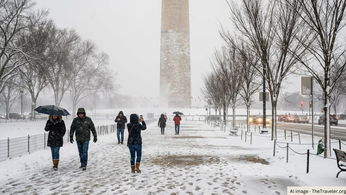
For the millions of travelers who come to Washington, DC each year to explore its monuments, memorials, and world-class museums, the timing of this storm could upend carefully arranged itineraries. While many of the city’s most iconic sites on the National Mall remain technically accessible in snow, the experience can be drastically different when sidewalks are icy, visibility is low, and wind-driven flakes obscure familiar landmarks.
National Park Service crews typically work to clear primary walkways around high-traffic monuments such as the Lincoln Memorial, Washington Monument grounds, and the World War II Memorial, but deep or rapidly accumulating snow can make it difficult to keep pace. Stairs and stone surfaces can quickly become slick, and open plazas offer little protection from wind and blowing snow for visitors attempting to take photos or join ranger talks.
Indoor attractions, including Smithsonian museums, the National Gallery of Art, and other cultural institutions, may face staffing challenges as employees contend with their own commutes. That can lead to delayed openings, reduced hours, or full-day closures if conditions are severe. Visitors holding timed-entry passes should anticipate possible changes and check for updated operating status the morning of their visit.
Guided tours, including walking tours, Segway outings, bike rentals, and night tours of the monuments, are particularly vulnerable to cancellation during significant winter storms. Tour operators often make final decisions based on forecast confidence and safety considerations for both staff and guests, so travelers should watch for messages from their providers and be ready to reschedule.
Hotels, Events, and Local Businesses Shift to Storm Mode
Across the city’s hospitality industry, hotels, restaurants, and event venues are moving into contingency planning as confidence grows in a disruptive snowstorm. Large downtown hotels are coordinating with staff to arrange overnight accommodations or alternative transportation so critical departments, from front desk to housekeeping and food service, can remain operational even if commuting becomes difficult.
Conferences, conventions, and special events scheduled over the storm window may see reduced attendance or last-minute cancellations as attendees are grounded by flight disruptions or decide not to risk driving. Organizers are reviewing contracts, revisiting virtual participation options, and preparing to communicate changes quickly to registrants.
Restaurants and bars, many of which rely on business travelers and tourists alongside local diners, are weighing whether to remain open on abbreviated hours, pivot to limited menus, or temporarily shutter if conditions deteriorate. Neighborhood spots in walkable areas may still see a trickle of local customers, but venues that depend on commuters or tourists arriving by car will be especially exposed to the storm’s fallout.
Retail shops in key visitor corridors, from Georgetown and Dupont Circle to Penn Quarter and along the Wharf, are likewise expecting a slump in foot traffic during the height of the storm. Some may use the lull to restock or rearrange inventory, while others will ride out the weather with skeleton crews. Visitors already in the city should plan on reduced options for dining and shopping, particularly in the evening and early morning hours.
What Travelers Need to Do Right Now
With the window for preparation narrowing, both residents and visitors are being urged to act now to reduce risk and uncertainty. Anyone with upcoming flights into or out of the Washington region during the projected storm period should review their reservations immediately, check airline waiver policies, and consider shifting travel by a day on either side if schedules allow.
Visitors driving into the District or renting cars for regional trips should reassess their plans, especially if they are unfamiliar with winter driving. Authorities stress that heavy snow, limited visibility, and icy ramps can quickly overwhelm even experienced motorists. Where possible, travelers are being encouraged to rely on rail or transit before and after the storm rather than attempting long highway drives during active snowfall.
For those already in the city with packed sightseeing agendas, the guidance is to prioritize flexibility. Build alternative indoor activities into the plan, such as museum visits, neighborhood cafes, or hotel amenities, and be prepared to shift outdoor monument visits to calmer weather windows. Checking official channels the morning of each day will be essential to confirm whether attractions are open and operating normally.
Packing for winter conditions is also critical. Sturdy, waterproof footwear with good traction, layered clothing, gloves, hats, and scarves can make the difference between a short, uncomfortable walk and a safe, if chilly, journey around the Mall or between transit stations. Travelers should also carry a charged phone, portable battery, and any necessary medications in a day pack in case they face unexpected delays.
Safety First: Avoiding Common Winter Storm Pitfalls
Officials across the region are emphasizing a simple message as the storm approaches: safety must come before sightseeing. Even a city as accustomed to visitors as Washington can struggle when heavy snow coincides with peak commuting hours or weekend events, and the choices travelers make can either reduce or add to the strain on emergency services.
Drivers are being reminded not to abandon vehicles on major routes if they become stuck, as that can impede plow operations and slow rescue responses. Visitors who are unaccustomed to snow should think carefully before attempting to drive on unfamiliar, hilly streets, particularly at night when visibility is lowest and temperatures are coldest. Choosing to stay put in a hotel or nearby restaurant for a few hours can often be the safer choice.
Pedestrians, too, face heightened risks. Snow-covered curbs, hidden ice patches, and narrowed sidewalks can force people closer to the roadway, where visibility for drivers is already compromised. Walking slowly, wearing proper footwear, and avoiding distractions such as phones while crossing streets can help reduce the chance of slips, falls, and close calls with vehicles.
For families traveling with children or older adults, building in extra time and rest breaks is essential. Cold stress and fatigue can set in quickly in windy, snowy conditions. Keeping an eye on weather alerts and local advisories, and being willing to cut a day short if conditions worsen, remain some of the most important steps any traveler can take as Washington, DC faces what could be one of its most disruptive snow events of the season.