
More news on this day
On a quiet slope of the Yorkshire Wolds, the abandoned settlement of Wharram Percy continues to rank among England’s best known deserted medieval villages, attracting visitors keen to walk through centuries of rural history preserved in grassed-over streets and a ruined parish church.
Get the latest news straight to your inbox!
A Landscape Shaped by Centuries of Settlement and Decline
Wharram Percy lies on the western edge of the Yorkshire Wolds in North Yorkshire, overlooking a narrow valley known as Deep Dale. Publicly available information shows that a settlement existed here by the later prehistoric period, with a village taking recognizable medieval form from around the 9th or 10th century. For roughly 600 years it was a lived-in community, its fields, mills and manor houses tied into wider regional markets and landowning networks.
The village expanded through the 12th and early 14th centuries, when members of the powerful Percy family held estates in the area and the parish church of St Martin developed from earlier timber and stone structures into a more substantial Gothic building. Archaeological syntheses indicate that Wharram Percy followed a familiar medieval pattern, with planned rows of peasant houses arranged along streets and lanes, backed by long garden plots and surrounded by open fields worked in common.
By the late 15th and early 16th centuries, however, the village faced a prolonged decline. Research published by English Heritage and Historic England links the abandonment to a mixture of gradual desertion, changing agricultural practices and deliberate evictions, as landowners converted arable land to pasture. By around 1500 most of the population had gone, leaving the church and a scattering of farm buildings as the last echoes of a once-busy settlement.
Today the site is protected as a scheduled ancient monument and managed in guardianship by English Heritage, while ownership of the surrounding farmland remains with a private estate. That combination of long-term protection and agricultural continuity has helped preserve the earthworks and rural character that now shape the visitor experience.
Why Wharram Percy Became the Classic Deserted Medieval Village
Although thousands of deserted or shrunken medieval villages are known across Britain, Wharram Percy has acquired a particular status in both research and public imagination. Historic England’s survey work and decades of excavation describe it as arguably the best known deserted medieval village in the country, thanks to the scale of investigation carried out between the late 1940s and the early 21st century.
From 1948 onward, the Wharram Research Project used the site as a pioneering laboratory for techniques that later became standard in landscape archaeology. Published reports highlight the use of open-area excavation, detailed earthwork survey, environmental analysis and the integration of manorial records, parish documents and maps. The result was a finely textured picture of everyday peasant life that went far beyond earlier, more descriptive treatments of abandoned villages.
This intensive research generated a substantial body of publications, culminating in a multi-volume series that explored everything from the layout of peasant longhouses to patterns of diet, health and landholding. The scale and accessibility of that scholarship helped cement Wharram Percy’s reputation in textbooks, university courses and popular history features that point to it as the archetypal deserted medieval village.
More recent academic work has continued to use Wharram Percy as a reference point for wider debates about medieval rural society, including questions of social hierarchy, resistance to eviction and the impact of climate and economic change. That ongoing attention keeps the village in the news cycle of archaeological research and heritage management, reinforcing its profile far beyond North Yorkshire.
Walking Through Ruins and Earthworks in the Yorkshire Wolds
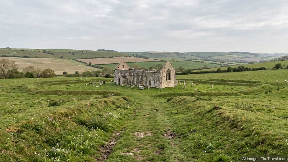
For visitors, Wharram Percy offers a combination of clear archaeological remains and atmospheric scenery that is relatively rare among deserted medieval villages. According to publicly available visitor information, the site is free to enter and open in daylight hours, with access via a dedicated car park and a signed footpath leading roughly three quarters of a mile down into the valley.
The route into the site follows an ancient hollow trackway, where the grassy banks and worn path hint at centuries of movement between fields and village. At the heart of the settlement stand the ruins of St Martin’s Church, its roofless walls framing Gothic windows and later additions that specialists have traced through at least six construction phases between the 12th and early 17th centuries. Information boards and marked outlines on the ground guide visitors to the locations of two manor houses, peasant dwellings, barns and yards that once lined the village streets.
Beyond the core of the settlement, the slopes of the valley are scored by medieval field systems and later agricultural features. A former millpond, now a tranquil hollow with wetland vegetation, recalls the watermill that once processed grain from the surrounding open fields. On the higher ground, subtle ridges and terraces reveal the long plots associated with peasant houses, giving a sense of how domestic and agricultural spaces interlocked.
The surrounding countryside remains largely agricultural, with livestock grazing and arable fields shaping views across the Wolds. Tourism and regional promotion material describes Wharram Percy as an appealing stop on journeys between York and the coast, and as a rewarding detour for walkers following long-distance routes such as the Centenary Way and other local trails.
Conservation, Research and Visitor Management Today
Recent technical reports from Historic England and English Heritage indicate that Wharram Percy continues to be the focus of conservation planning and monitoring. A detailed analytical survey of the earthworks has been carried out to inform future management of erosion, vegetation and visitor pathways. The site’s scheduled status means that any intrusive work is strictly controlled, helping to safeguard buried archaeology while allowing for limited research-led excavation when required.
Conservation documentation notes that the church ruins and remaining post-medieval cottages require ongoing stabilisation and inspection to address issues such as falling masonry and weathering. On-site signage warns visitors about steep slopes, uneven ground and deep water near the former millpond, reflecting efforts to balance open access with safety on a landscape that has changed little in character while still presenting natural hazards.
Digital resources have become an important part of how Wharram Percy is interpreted for the public. English Heritage provides an audio tour and downloadable guides that explain the phasing of buildings, the story of abandonment and the wider archaeological significance of the site. Academic archives hosted by the Archaeology Data Service make excavation records, plans and photographs available for researchers and interested members of the public.
Local and regional tourism sites highlight Wharram Percy’s role within a broader cluster of heritage attractions in North Yorkshire, from nearby priory ruins to coastal castles and the historic city of York. Updated visitor reviews emphasize the quiet, rural character of the walk to the village and the rewarding views back across the valley, underscoring its appeal for both history enthusiasts and casual walkers.
Wharram Percy’s Ongoing Pull for Visitors and Researchers
Interest in Wharram Percy shows little sign of fading. Heritage blogs and regional travel features continue to single it out as the classic example of a deserted medieval village, citing the clarity of its earthworks and the depth of published research. Aerial and drone photography circulating in recent years has brought new visual perspectives on the layout of the village, making its pattern of streets, house plots and fields more legible to non-specialists.
At the same time, current scholarship continues to revisit the large archive of finds and records generated by mid- and late-20th-century excavations. Recent theses and journal articles explore themes such as peasant agency, patterns of consumption and the social meaning of domestic architecture at Wharram Percy, using the site to probe broader questions about rural life in late medieval England.
For visitors arriving today, the attraction lies partly in that blend of scholarly fame and physical quiet. There are no modern buildings at the heart of the site, no ticket booths or cafés, only information panels, grazing livestock in nearby fields and the sound of wind in the valley. The walk back up to the car park reinforces the sense of the village as a place apart, cut off not only by time but by topography.
As conservation plans evolve and digital interpretation expands, Wharram Percy is likely to remain a central reference point for how deserted medieval villages are understood, presented and experienced. Its ruined church and grassed-over streets continue to provide a rare, tangible link to the rhythms and upheavals of England’s medieval countryside, ensuring its place on both academic maps and travel itineraries.