
The Gironde estuary is one of those places in France that quietly rewrites your sense of scale and connection to the sea. Stretching between the vineyards of Bordeaux and the open Atlantic, this broad, restless tongue of water is at once a shipping corridor, a winemaking backbone, a sanctuary for birds, and a living laboratory for climate change. To travel along it is to discover how geography, history, culture and ecology can interlock so tightly that the place becomes impossible to compare with anywhere else in the country.
The Largest and Wildest Estuary in Western Europe
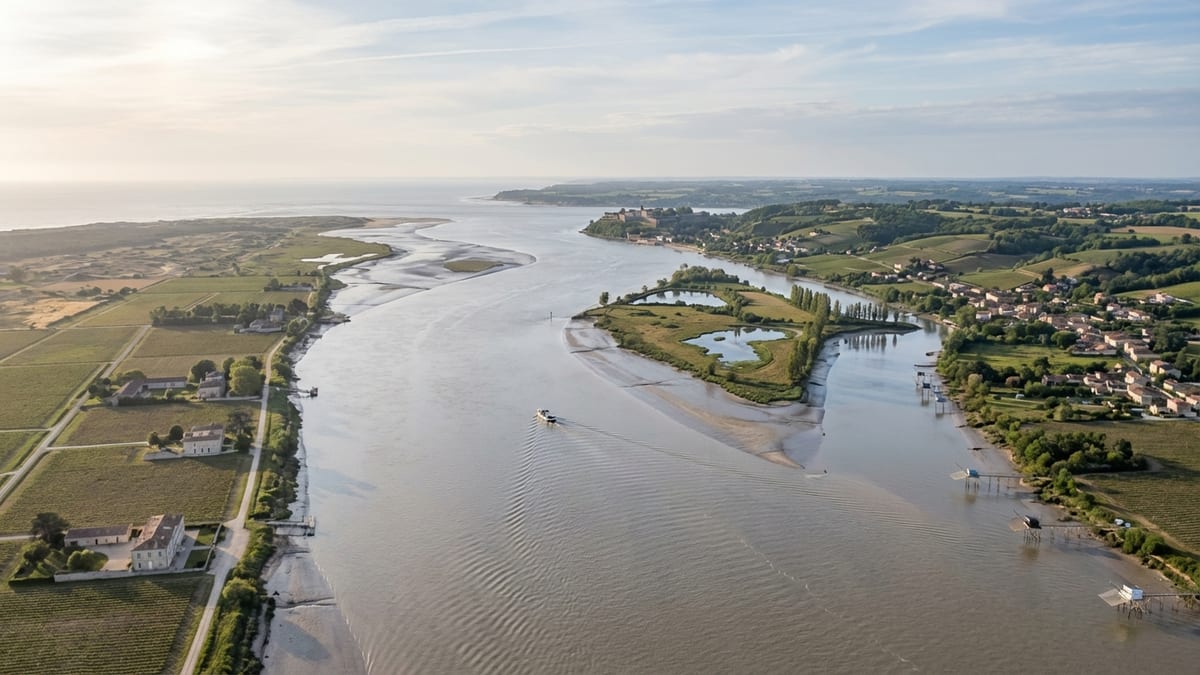
The first thing that sets the Gironde apart is its sheer size. Formed where the Garonne and Dordogne rivers meet just downstream from Bordeaux, the estuary runs for roughly 75 kilometers before opening into the Atlantic. At its widest, near the mouth, it spans up to about 12 kilometers, covering some 635 square kilometers of shifting channels, shoals and mudflats. It is widely recognized as the largest estuary in Western Europe, and locals like to compare its scale to that of the Mississippi.
This size is not just a cartographic curiosity. The Gironde functions as a dynamic transition zone between river and ocean, with strong tidal currents that constantly reshape its bed and banks. Sandbanks emerge and disappear, channels migrate, and islands are born or eroded away. Navigating this environment requires deep local knowledge, and historically it has demanded sophisticated infrastructure from pilots, harbor authorities, and lighthouse keepers.
The landscape along its shores reflects that tension between water and land. On the left bank, the flat alluvial plain of the Médoc stretches inland, initially dominated by world-famous vineyards before giving way to marshes and coastal dunes closer to the Atlantic. On the right bank, the terrain rises into low hills planted with the vineyards of Blaye and Bourg, their slopes dropping sharply toward the estuary. North of Blaye, extensive marshlands provide one of the richest wetland habitats on the French Atlantic coast.
For traveling visitors, this scale translates into a surprising sense of openness. Ferry crossings between Royan and the Médoc, river cruises from Bordeaux, and small boat excursions around the estuary’s islands all reveal a broad, horizon-scale waterway that feels more like an inland sea than a river mouth, yet remains framed by human activity on both banks.
A Living Mosaic of Islands and Wetlands
If the Gironde is exceptional in size, it is even more remarkable in its internal geography. Scattered along its central channel between Bec d’Ambès and the Pointe de Grave is an archipelago of low-lying islands with names that recur in local lore and wine lists alike: Patiras, Île Nouvelle, Île Pâté, Île Verte, Île Nord, Cazeau, Margaux and Macau, among others. Some are little more than vegetated sandbanks; others have long histories of cultivation, fortification, or habitation.
These islands are part of what gives the estuary its sense of constant change. Subject to powerful tidal currents and periodic floods, they are shaped and reshaped by silt carried from deep inland. Certain islands, such as Île Nouvelle and Patiras, have been the focus of restoration and conservation projects, turning former agricultural land into refuges for migratory birds, amphibians and small mammals. Others remain agricultural and viticultural outposts, with vines planted on alluvial soils that are periodically threatened by storm surges and high tides.
The surrounding marshes on both banks deepen this ecological mosaic. On the right bank north of Blaye, broad wetlands serve as breeding grounds for storks, spoonbills, herons and birds of prey, and they provide foraging areas for otters and other semi-aquatic species. These zones are integrated into regional nature reserves and birdwatching circuits, making the Gironde a key stopover on migratory routes stretching along the Atlantic flyway.
Recognizing this richness and vulnerability, the French authorities created the Gironde Estuary and Pertuis Sea Marine Nature Park, a vast protected area that wraps around the estuary and adjacent coastal waters. Within its boundaries, oyster farms, fishing huts, traditional nets on stilts, and small harbors coexist with the needs of wildlife. For visitors, this means that a boat trip or a walk on the banks is rarely just a scenic outing; it is a close encounter with one of France’s most intricate estuarine ecosystems.
A Wine Estuary at the Heart of Bordeaux’s Identity
What makes the Gironde especially distinctive in the French imagination is its tight linkage with one of the world’s most celebrated wine regions. The estuary is the main artery that once carried barrels from inland châteaux to the port of Bordeaux, and it still shapes the reputation and microclimates of the vineyards on both banks.
On the left bank, the Médoc’s legendary appellations stretch roughly parallel to the Gironde: Margaux, Saint-Julien, Pauillac, Saint-Estèphe. Châteaux here owe much to the estuary’s moderating influence, which tempers winter cold and summer heat. Morning mists rise from the water and drift over the vines, and the mix of gravel, clay, and sand deposited by the river system for millennia underpins the complexity of the wines.
Opposite, on the right bank, the Côtes de Blaye and Côtes de Bourg look out over the estuary from slopes that catch the light at different angles and are sheltered from Atlantic storms by the Médoc peninsula. Many family-run estates here still load wine onto small boats for promotional cruises along the estuary, echoing centuries-old trading practices. Although railways, roads and container ports have taken over the bulk of logistics, the symbolic role of the Gironde as a wine highway remains deeply rooted.
Traveling along the estuary, you encounter numerous viewpoints where vineyards plunge almost to the water’s edge, with traditional stone houses, low jetties and fishermen’s huts on stilts lining the shore. Tasting rooms, interpretation centers, and wine routes on both banks increasingly frame the estuary as a unifying feature rather than a dividing line, encouraging visitors to view it as the shared landscape that shapes Bordeaux’s global wine story.
Cordouan and the Military Heritage of a Strategic Waterway
The Gironde’s size and position have given it strategic importance for centuries, another aspect that makes it unique in France. At the very mouth of the estuary, set on an isolated rocky plateau exposed to Atlantic storms, stands the Cordouan Lighthouse, often called the King of Lighthouses. Constructed between the late sixteenth and early seventeenth centuries and raised in height in the eighteenth century, this monumental tower in dressed limestone was conceived as both a masterpiece of engineering and a symbol of royal power at the gateway to Bordeaux.
Cordouan’s architecture blends Renaissance ornamentation with later neoclassical additions, including a chapel and ceremonial spaces that once underscored the prestige of the French monarchy. Despite constant exposure to waves, currents and salt-laden winds, the lighthouse remains active and accessible to visitors in suitable weather. In 2021 it was inscribed on the UNESCO World Heritage List as an outstanding example of lighthouse construction and maritime heritage, cementing the Gironde’s status as home to one of the world’s most celebrated beacons.
Further inland, the estuary hosts another UNESCO-recognized ensemble: the so-called lock of the Gironde estuary, a triptych of fortifications designed by the military engineer Vauban in the seventeenth century. Together, the Citadel of Blaye on the right bank, Fort Pâté on an island, and Fort Médoc on the left bank once controlled the strategic bottleneck of the estuary, protecting Bordeaux from naval incursions. Their interlocking fields of fire created an early-modern defense system that high-level decision makers later judged so effective that it was barely tested in battle.
Today these sites have been carefully restored and opened to the public, with walking paths, exhibitions and panoramic viewpoints over the estuary’s central section. For visitors interested in history, they offer a rare opportunity to grasp how the geography of a wide, tidal waterway shaped military thinking, and how those defenses in turn helped secure the prosperity of Bordeaux and its hinterland.
A Theatre for Rare Tidal Phenomena
Beyond its human monuments, the Gironde is renowned for a dramatic natural event that sets it apart from most estuaries in France: the tidal bore, known locally as the mascaret. This is a surge of water that travels upriver like a low wall, created when a high incoming tide under particular conditions of river flow and tidal coefficient forces its way against the outgoing current. Only a handful of rivers worldwide experience tidal bores; in France, the phenomenon is notable on the Dordogne and, to a lesser extent, the Garonne.
In the Gironde system, the mascaret is typically observed between late spring and early autumn, when tidal ranges in the Bay of Biscay are at their highest and river discharge is moderate. On the Dordogne in particular, the bore can reach heights of around 1.5 to 2 meters and travel at speeds of 20 to 30 kilometers per hour. It advances with a hissing roar, preceded by a subtle sucking sound as the current reverses, and at certain bends and straight stretches it forms well-shaped, surfable waves that attract enthusiasts from across Europe.
Villages such as Saint-Pardon, Vayres and other small ports along the Dordogne and Garonne have developed a modest but distinctive culture around this event, with tide calendars, festivals and gatherings timed to the most powerful bores of the year. Professional guides, local volunteers and municipal authorities stress safety, encouraging spectators to watch from elevated banks and warning of floating debris and strong currents that follow in the bore’s wake.
From a traveler’s perspective, witnessing the mascaret is one of the most striking things you can do in the Gironde region. It epitomizes the constant negotiation between river and ocean in this estuary, and it gives a visceral sense of how the gravitational pull of the moon can manifest in a very localized, almost theatrical way on a quiet rural morning.
An Estuary Shaped by Navigation, Trade and Modern Tourism
The Gironde’s role as a navigation channel has always been central to its identity. As the main maritime access to the port of Bordeaux, it has carried merchant convoys, naval squadrons, fishing boats and, more recently, cruise ships. The estuary’s shifting shoals and strong currents pose challenges that demand constant dredging, updated charts, and specialist pilotage services, but they also form part of its character as a working waterway rather than a static scenic backdrop.
Historically, the estuary came under international spotlight during the age of sail, when Bordeaux emerged as a major Atlantic port dealing in wine, timber, colonial goods and, tragically, the slave trade. Later, in the twentieth century, the Pointe de Grave and surrounding approaches took on military significance again with the arrival of Allied troops in the First World War and German coastal fortifications in the Second. Ruins and memorials along the banks and at the Atlantic entrance still bear witness to those episodes.
In recent decades, however, the focus has shifted toward sustainable tourism and soft mobility along the estuary. River cruises now link Bordeaux with Blaye, Pauillac, Bourg and other small ports, allowing visitors to sample wines and local gastronomy while learning about tidal dynamics and wildlife. Ferries shuttle cars and cyclists across the broad mouth between Royan and the Médoc, while long-distance cycling routes such as those that follow the Atlantic coast skirt the estuary’s edge, connecting coastal resorts, oyster-farming villages, and vineyard landscapes.
Small-scale tourism initiatives emphasize the vernacular culture of the estuary: traditional fishing huts known as carrelets perched on stilts over the water, seasonal net fishing for shad and eel, and the understated architecture of riverside villages that live at the rhythm of spring tides and harvest seasons. For travelers willing to slow down, the Gironde offers a strong sense of place that is inseparable from everyday life on its banks.
Climate Change, Conservation and a Fragile Future
What also makes the Gironde unique today is the way it concentrates many of the environmental pressures and policy debates that define coastal France in the early twenty-first century. Sea-level rise, more frequent winter storms, and changes in river flow patterns linked to climate change all pose risks to an estuary whose banks are low-lying, whose islands are barely above high tide in places, and whose heritage sites and vineyards often sit close to the water.
Erosion is particularly pronounced along some sections of the estuary, where tidal currents undercut clay cliffs and marsh edges. Flooding during storm surges can inundate agricultural land and threaten infrastructure, while salinity intrusion during prolonged dry spells alters habitats and complicates freshwater management. These challenges have placed the Gironde at the forefront of research and experimentation in estuarine adaptation and risk management in France.
Regional institutions, local authorities and scientific partners have launched a range of programs to monitor sediment transport, model future shoreline evolution, and test nature-based solutions such as wetland restoration and managed realignment of dikes. The establishment of the marine nature park around the estuary reflects a broader push toward integrated management that takes navigation, biodiversity, fisheries, tourism and cultural heritage into account rather than treating them as separate issues.
For visitors, this evolving reality adds a new dimension to any trip along the Gironde. Interpretation centers, guided walks and educational cruises often highlight not just the estuary’s beauty and history, but also the precarious balance that must be maintained if its islands, marshes, wine landscapes and lighthouses are to be passed on to future generations in anything like their current form.
The Takeaway
The Gironde estuary is unique in France because it concentrates, in a single, sweeping waterway, the country’s long relationship with the Atlantic, its winemaking genius, its military and maritime heritage, and many of its present-day environmental dilemmas. It is at once the largest and one of the least urbanized estuaries in Western Europe, a place where broad horizons and shifting sandbanks are interlaced with fortified citadels, Renaissance lighthouses, and neatly ordered rows of vines.
To travel here is to experience a landscape that never quite settles. Tides race up from the Bay of Biscay, sometimes forming the rare mascaret; rivers deliver silt and freshwater from the heart of southwestern France; birds trace seasonal routes overhead; and human communities work, adapt and celebrate in tune with these cycles. Unlike more familiar coastal destinations defined principally by beaches or ports, the Gironde offers something more complex: a living estuarine world where river, ocean and land are in constant negotiation.
For travelers in search of depth rather than spectacle, that interplay is precisely what makes the Gironde estuary so compelling. It is not only a backdrop to Bordeaux’s wines or a corridor to the Atlantic, but a place in its own right, with its own rhythms and stories, that continues to evolve while remaining unmistakably itself.
FAQ
Q1. Where exactly is the Gironde estuary located in France?
The Gironde estuary lies in southwestern France, beginning just downstream from the city of Bordeaux where the Garonne and Dordogne rivers meet, and extending northwest to the Atlantic Ocean between the Médoc peninsula and the Royan area.
Q2. Why is the Gironde considered unique among European estuaries?
It is the largest estuary in Western Europe, combining exceptional ecological diversity, a dense concentration of wine regions, major maritime heritage sites such as Cordouan Lighthouse and the Vauban fortifications, and rare tidal phenomena like the mascaret, all within a relatively sparsely urbanized landscape.
Q3. What is special about the islands in the Gironde estuary?
The estuary’s islands are constantly shaped by tides and sediment, creating a mix of natural reserves, agricultural land and historical sites. Some, like Île Nouvelle, are important for birdlife, while others such as Patiras and Margaux Island link directly to the region’s wine and farming traditions.
Q4. Can visitors reach Cordouan Lighthouse, and why is it important?
In suitable tide and weather conditions, boat excursions from nearby ports take visitors to Cordouan Lighthouse, where landings are timed with low tide. The lighthouse is important for its Renaissance and neoclassical architecture, its long role in guiding ships to Bordeaux, and its recognition as a UNESCO World Heritage Site.
Q5. What is the mascaret and where can it be seen?
The mascaret is a tidal bore, a powerful surge that travels upriver when high Atlantic tides meet the outgoing flow of the Dordogne and, more modestly, the Garonne. It is best observed from late spring to autumn near places such as Saint-Pardon and Vayres, where the river’s shape creates rideable waves for surfers and paddlers.
Q6. How does the estuary influence Bordeaux’s wines?
The Gironde moderates the local climate, limiting extremes of heat and cold and creating morning mists that affect grape ripening and disease pressure. Its long geological history of sediment deposition helped form the gravelly and varied soils that underpin the character of appellations on both banks, especially in the Médoc and the Côtes.
Q7. Is the Gironde estuary a good destination for nature lovers?
Yes. The combination of islands, marshes, mudflats and coastal dunes makes it one of France’s richest estuarine environments. Birdwatching, guided wetland walks, and nature-focused boat trips offer frequent encounters with migratory birds, waders, raptors and a wide range of plant communities adapted to brackish conditions.
Q8. What kinds of activities can travelers enjoy on the estuary?
Travelers can take river cruises from Bordeaux or smaller ports, ride ferries across the mouth of the estuary, explore historic citadels and forts, visit lighthouses and fishing huts, taste wines at nearby châteaux, cycle or hike along the banks, and, at certain times of year, watch or even surf the mascaret.
Q9. Are there concerns about climate change in the Gironde estuary?
Yes. Rising sea levels, stronger winter storms and altered river flows pose risks of erosion, flooding and salinity changes that threaten wetlands, agriculture, infrastructure and heritage sites. Local and national authorities are investing in monitoring, protective works and nature-based solutions to adapt the estuary to these evolving conditions.
Q10. How much time should a visitor plan to explore the Gironde estuary?
A full appreciation of the estuary’s diversity usually requires several days. With two or three days you can combine Bordeaux, a river cruise, a visit to at least one fort or lighthouse, and some wine tasting. A longer stay of four to seven days allows deeper exploration of islands, marshes, both banks’ vineyards and coastal areas near the Atlantic entrance.