
California is more like a small country than a single US state. Snow capped peaks, surf towns, wine valleys, mystical deserts and global cities all compete for your travel days. With so many options, deciding where to go first can feel overwhelming. This guide ranks California’s top regions for visitors, highlighting what each does best, when to go, and who it suits most, so you can build a trip that matches your style rather than chasing every postcard view at once.
How to Think About California’s Regions
California stretches more than 750 miles from north to south, and the character of the state changes dramatically as you move between its major regions. Most travelers focus on a handful of classic areas: the greater Los Angeles basin, the Bay Area and Wine Country, the Central Coast, the Sierra Nevada, the deserts and a slice of the far north. Each has distinct landscapes, climates and cultures, and travel distances between them are often longer than they look on a map.
When ranking California’s regions for travel, three factors tend to matter most. First is visual drama, the kind of scenery that makes the state famous, from Big Sur cliffs to Yosemite granite walls. Second is density of experiences, meaning how many worthwhile sights, neighborhoods, and outdoor options you can reasonably fit into a few days without spending all your time in the car. Third is practicality: ease of access, driving conditions, wildfire or storm disruptions, and availability of lodging at different budgets.
California is also changing quickly. Coastal highways that once closed for months after landslides, such as the Big Sur section of Highway 1, are currently open as of early 2026, making certain routes more realistic for road trips again. At the same time, wildfire seasons, heat waves and winter storms are increasingly shaping when and how people travel. Planning by region rather than by isolated attractions helps you adjust more easily to conditions on the ground while still seeing the best of the state.
With that in mind, the rankings below start with the regions that deliver the strongest mix of scenery, activities and accessibility for first or second time visitors, then move into more specialized corners of the state that reward travelers with extra time or a specific passion, such as hot spring hopping or dark sky stargazing.
1. The Central Coast & Big Sur: California’s Signature Scenic Drive
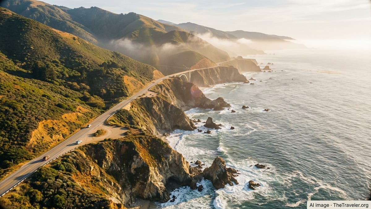
If you had to pick one region that captures the California of daydreams, the Central Coast would be it. Running roughly from Santa Barbara to just south of San Francisco, this stretch of shoreline folds together wine country, small beach towns and one of the most dramatic coastlines in North America. The star is Big Sur, where the Santa Lucia Mountains plunge almost directly into the Pacific and Highway 1 threads along cliffs and coves with almost continuous ocean views. As of early 2026, the famed Big Sur Coast Highway is fully open after a multiyear closure from landslides, restoring one of the world’s classic road trips.
Big Sur itself is more a region than a town. Turnouts reveal sea stacks and surf far below, while trailheads lead into redwood canyons and high ridges with condor and whale watching in season. Lodging is limited and often expensive, ranging from rustic cabins to design forward hideaways, and camping requires advance planning. For many travelers, the best approach is to use nearby hubs such as Carmel by the Sea, Monterey or Cambria and explore Big Sur as a loop or one way drive, stopping for short hikes, viewpoints and picnics rather than trying to tick off every named landmark.
Outside Big Sur, the Central Coast slows down in all the right ways. Santa Barbara mixes Spanish Revival architecture with palm edged beaches and an urban tasting room scene. San Luis Obispo and nearby coastal villages like Pismo Beach and Avila Beach offer mellow surf, farmers’ markets and easy trail access. Inland, Paso Robles has emerged as a serious wine region with relaxed tasting rooms, hot springs and a growing restaurant scene. The climate here is generally mild, though winter storms can bring heavy rain and temporary road closures, and summer can be hot a few miles inland while the coast stays cool under a marine layer.
For a first or second trip to California, the Central Coast works beautifully as the spine of a larger itinerary. It connects naturally to either San Francisco or Los Angeles, breaks up long drives and delivers a high ratio of memorable scenery to driving time. If your image of California includes ribbon like coastal roads, fog lifting off cliffs and sunsets over the Pacific, this should sit at the top of your list.
2. Yosemite & the Sierra Nevada: Granite Walls and Alpine Lakes
The Sierra Nevada range, with Yosemite National Park at its heart, is where California’s scenery turns from beautiful to almost theatrical. Yosemite Valley’s sheer granite walls, seasonal waterfalls and meadow floor create a compact stage for some of the most famous views in the American West. Beyond the valley, the park protects a vast high country of domes, forests and backcountry lakes, with trail access to longer wilderness routes for experienced hikers.
While Yosemite draws the headlines, the broader Sierra Nevada region offers many different flavors of mountain travel. Lake Tahoe on the state’s northern Sierra border is a year round playground with ski resorts in winter and hiking, boating and beachgoing in summer. The Eastern Sierra, hugging Highway 395, offers a more low key experience with hot springs, alpine trailheads and small towns like Bishop and Mammoth Lakes acting as outdoor bases. Further south, Sequoia and Kings Canyon National Parks protect groves of giant sequoias and deep glacial valleys that see far fewer visitors than Yosemite but offer similarly grand landscapes.
Seasonality is crucial in this region. Heavy winter snow can close high passes and certain park roads well into late spring or early summer in high snowfall years, limiting access to some trailheads and viewpoints. In late summer and early fall, wildfire smoke and fire related closures can instead become the issue, particularly on the eastern side of the range. Planning flexibility, travel insurance and careful attention to forecasts and park advisories all help. When conditions are favorable, though, the Sierra offers some of the clearest air, starriest skies and most rewarding hiking in the state.
For travelers willing to trade urban comforts for immersion in nature, the Sierra Nevada justifies multiple days in any California itinerary. Families can stick to front country lodges, lakeside cabins and short day hikes, while experienced hikers and climbers can build entire trips around multi day backpacking routes or technical ascents. The region is best seen at a slower pace, with time to adjust to altitude and to let the light change across the granite each day.
3. San Francisco Bay Area & Wine Country: Culture, Coast and Vineyards
The San Francisco Bay Area and its neighboring wine valleys offer an unusually dense mix of urban culture, iconic landmarks and nearby nature. San Francisco itself is compact enough to explore on foot and public transport, yet varied enough in its neighborhoods and microclimates to feel like several cities stitched together. Victorian lined streets give way to modern waterfront parks, while the Golden Gate Bridge anchors views from almost every angle. Cool, foggy summers and mild winters make it a viable year round destination, though packing layers is essential in any season.
Across the bay and to the north, Napa Valley and Sonoma County translate California’s agricultural abundance into a landscape of vineyards, farm to table restaurants and quiet country roads. Napa is known for high profile wineries and polished hospitality, while Sonoma spreads out over a larger area with a mix of vineyard towns, redwood groves and a rugged Pacific shoreline. Tasting experiences now range from casual, family run estates to architecturally ambitious wineries that pair art installations with carefully managed views of the vines.
Beyond wine, the broader Bay Area hosts national park sites and open spaces that can easily fill an active traveler’s itinerary. The Marin Headlands and Point Reyes National Seashore combine coastal cliffs, hiking trails and wildlife viewing within about an hour’s drive of downtown San Francisco in light traffic. To the south, the Peninsula’s protected hills and preserves offer redwood walks and ridgetop views. East across the Bay Bridge, the cities of Oakland and Berkeley provide their own food, music and arts scenes along with trail networks in the nearby hills that look back across to the San Francisco skyline.
For visitors who prefer a blend of city life and nature rather than focusing solely on one or the other, the Bay Area and Wine Country rank near the top of California regions. Good public transport within San Francisco and growing options for organized day trips to nearby parks and vineyards mean you can see a surprising amount without renting a car, though having one remains the easiest way to reach trailheads and smaller towns. The main tradeoff here is cost; lodging, dining and tasting fees can add up quickly, so advance budgeting and off season travel can help make the region more affordable.
4. Los Angeles & the Southern California Coast: Beaches, Culture and Sprawl
Greater Los Angeles is less a single city and more a patchwork of distinct neighborhoods, beach towns and satellite cities stretching from the mountains to the sea. For travelers, that can be both the appeal and the challenge. On one hand, you can surf in the morning, visit a major museum in the afternoon and catch a live show or sports event at night. On the other, distances are long and traffic is part of daily life, so choosing a couple of base neighborhoods and exploring them deeply often works better than trying to cross the entire metro area every day.
The classic Southern California coastal arc begins around Santa Monica and Venice, where bike paths trace the sand and a mix of street performers and beach volleyball courts create a lively atmosphere. Further south, Manhattan Beach and Hermosa Beach feel more local and residential, while the Orange County coast adds upscale enclaves like Newport Beach and Laguna Beach with coves, tide pools and coastal hiking in nearby preserves. Inland, Hollywood, Downtown Los Angeles, Pasadena and the Arts District each contribute their own architectural and cultural flavors, from historic theaters to contemporary galleries.
For first time visitors, Los Angeles rewards some pre trip honesty about priorities. Film and music fans may want to base near Hollywood or West Hollywood for studio tours and nightlife. Beach focused travelers might choose Santa Monica or one of the South Bay towns in order to minimize time spent commuting to the water. Families might opt for Anaheim or its surroundings for proximity to theme parks, combining those days with separate stays on the coast or in the city. Public transport is improving, with expanded rail lines connecting parts of the region, but a car still makes many itineraries vastly easier.
Weather is one of Southern California’s calling cards, with long stretches of sunny days and relatively mild temperatures. Marine layers can make early summer mornings gray and cool along the beaches, while inland valleys can be significantly hotter from late spring through early fall. Wildfire season in late summer and autumn can affect air quality and visibility, though large fire events are not guaranteed in any given year. Planning early dinners, leaving generous driving time, and building in non driving days where you explore a single neighborhood on foot all help turn the sprawl into an advantage rather than a frustration.
5. The Desert Parks: Joshua Tree, Anza Borrego and Death Valley
California’s deserts feel like a different planet from its coasts and forests, but they belong on any ranking of the state’s top regions. Joshua Tree National Park, an easy drive from Palm Springs and the Los Angeles area, introduces travelers to where the Mojave and Colorado Deserts meet. Its namesake Joshua trees, boulder piles and wide skies make it a favorite for climbers, photographers and stargazers. Temperatures vary sharply by season; spring and late autumn tend to be more comfortable for hiking, while midsummer afternoons are often better spent in shade or near a pool in town.
Further south, Anza Borrego Desert State Park protects a vast sweep of badlands, palm oases and arroyos in the Colorado Desert. The region is known for seasonal wildflower blooms that, in good rainfall years, can transform the landscape for a few intense weeks and draw large numbers of visitors. Outside those peaks, it is one of the best places in California to experience true desert quiet, whether you are hiking, driving among eroded canyons or simply watching the stars in one of the darkest skies in the state. Basic services are more limited here than in national parks, so self sufficiency and careful planning for water, sun and navigation are crucial.
Death Valley National Park, straddling the California Nevada border, adds a sense of extremes to the desert experience. It is the hottest and one of the driest national parks in the United States, with salt flats below sea level, colorful badlands and canyons, and high viewpoints in the surrounding ranges that can be surprisingly cool at certain times of year. Distances within the park are long, cell service is unreliable in many areas, and fuel and food options are widely spaced, so visitors need to approach it more like a remote road trip than a casual day out from a city.
The desert parks collectively rank highly for travelers seeking big, uncluttered landscapes, night skies and winter sunshine. They also demand more respect for conditions than almost anywhere else in California. Ideal timing usually runs from late autumn through early spring, when daytime temperatures are reasonable and the risk of heat related illness is far lower. Checking park advisories, starting hikes early, and carrying more water than you think you need are not optional extras here; they are part of traveling safely in environments that are beautiful precisely because they are harsh.
6. Northern California Coast & the Redwoods: Quiet Forests and Wild Shores
North of the Bay Area, California’s coastline grows wilder, cooler and less populated. Mendocino, Humboldt and Del Norte counties back onto a Pacific edge of rocky headlands, windswept beaches and small harbors where the pace of life feels far removed from city traffic. Inland, the hills roll into forest and farmland before rising toward the Trinity Alps and the northern reaches of the Sierra and Cascade ranges. This is not a region of blockbuster attractions so much as a web of small experiences: tide pooling at low tide, watching fog move through a cove, or lingering over coffee in a clapboard town square.
The marquee draw here is the redwoods. State and national parks along the North Coast protect some of the tallest trees on Earth in groves that feel cathedral like in scale. Redwood National and State Parks, Humboldt Redwoods State Park and smaller reserves near Mendocino and Fort Bragg all offer a mix of scenic drives, short walks and longer hikes among these ancient forests. Light filters differently here; even on bright days, trails can feel dim and cool under the canopy, and mornings often begin in mist before the sun burns through.
Weather along the Northern California coast is generally cooler and wetter than further south, with a pronounced rainy season that usually runs from late autumn through early spring. Summers can be dry but foggy, with daytime highs that often stay far below inland temperatures, making the region appealing for travelers looking to escape heat waves. Lodging ranges from basic motels and campgrounds to romantic inns perched on cliffs, and dining often centers on seafood and locally grown produce rather than big city nightlife.
This region places high in any ranking for travelers who value quiet, space and time outdoors over urban buzz. It requires more driving than some other areas, as public transport options are limited and distances between towns can be significant. However, traffic is generally light, and the roads themselves often become part of the pleasure, winding through redwood corridors and along bluffs with almost constant views of sea and sky.
7. The Central Valley & Gold Country: Farms, History and Slower Roads
Running down the middle of the state, the Central Valley is California’s agricultural heartland. At first glance from a highway rest area, it can look like an unbroken stretch of fields and service towns. Look closer, and you find small cities with evolving food scenes, historic main streets and easy access to nearby foothills. Sacramento, the state capital, sits at the northern end of the valley and has been steadily adding museums, riverfront paths and neighborhoods of restored Victorian and Craftsman homes that reward a day or two of exploration.
To the east, the Sierra foothills preserve remnants of the Gold Rush era in a string of towns often grouped under the label Gold Country. Places like Nevada City, Grass Valley, Auburn, Placerville and Sonora hold onto Victorian storefronts, old hotels and small museums that tell the story of the 19th century mining boom and its impacts on Indigenous communities and the landscape. Today, many of these towns are shifting toward a mix of outdoor tourism, wine production and creative industries, with trail networks in nearby hills and rivers offering swimming holes in summer and colorful foliage in autumn.
Compared with the coastal regions, the Central Valley and Gold Country feel distinctly less polished and more lived in. Summer heat can be intense, with extended stretches of very high temperatures, particularly in the southern valley, while winters are generally mild and occasionally foggy at lower elevations. Wildfire risk is a recurring concern in the foothills during late summer and early autumn, and travelers should pay attention to air quality and local advisories during that period.
For visitors with extra time or a specific interest in California’s history and food systems, however, this region adds depth to a trip otherwise focused on beaches and big parks. Farm stands, local wineries and small breweries dot back roads, while state historic parks preserve mining sites, Indigenous heritage and riverfront landscapes. Slowing down here for a day or two can help break up long drives between more famous regions and offer a glimpse of the California that feeds the rest of the country.
8. Far Northern Mountains & the Volcanic Cascade: For Repeat Visitors
Beyond the familiar orbit of Yosemite and Lake Tahoe, the far north of California shifts into a quieter, more rugged mountain country. Here the Sierra Nevada blends into the southern Cascades and Klamath ranges, bringing volcanic peaks, clear rivers and forests that see far fewer visitors than the state’s marquee parks. Travelers need to be more self reliant and comfortable with longer drives, but the reward is space and a sense of discovery that can be hard to find along the more famous corridors.
Lassen Volcanic National Park showcases a compact mix of geothermal features, volcanic peaks and alpine lakes, offering something of a smaller scale counterpart to Yellowstone. Snow can linger on trails and roads well into summer in heavy snow years, but when open, the park’s network of short and moderate hikes leads to bubbling mud pots, sulfur vents and wide views. Further north, the area around Mount Shasta draws hikers, climbers and spiritually inclined visitors to a peak that dominates the local skyline and can be visible for many miles on clear days.
Elsewhere in this region, Trinity and Shasta counties offer river canyons popular with rafters and anglers, while small towns act as gateways to trailheads and campgrounds. Services are more spread out here than in central and southern parts of the state, and winter weather can be serious, with snow at higher elevations and heavy rain or road icing at lower ones. Wildfires and associated smoke have also affected the area in recent years, particularly during late summer.
In a ranking of California regions, the far north sits best as a choice for travelers who have already experienced the classic coast and Sierra routes and are looking for something less visited. It lends itself well to road trips that loop from the Bay Area or Sacramento into the mountains and back, perhaps connecting with the Oregon border. Travelers who make the effort often find it a highlight of their trip, not because of any single famous viewpoint, but because of the overall feeling of being deep in the state’s quieter backcountry.
The Takeaway
There is no single correct way to rank California’s regions, because each serves a different kind of traveler and trip. The Central Coast and Big Sur deliver the archetypal coastal drive with a balance of scenery and accessibility. The Sierra Nevada and Yosemite add the drama of mountains and alpine light, while the Bay Area and Wine Country provide an unusually rich mix of city culture and nearby nature. Los Angeles and the Southern California coast excel at beach life and entertainment, and the desert parks offer wide skies and solitude. The North Coast and redwoods, Central Valley and Gold Country, and the far northern mountains round out the picture with quieter, more contemplative landscapes.
For a first visit, combining one coastal region with one mountain or desert region creates a satisfying contrast without packing every day with long drives. Returning travelers can then branch into lesser known corners of the state, timing their trips around wildflower seasons, autumn colors, or winter storms that turn the Sierra into a snow bound playground. Whatever mix you choose, planning by region rather than chasing isolated attractions will help you experience California as a collection of distinct places, each with its own rhythm, rather than as a blur from one landmark signpost to the next.
FAQ
Q1. What is the best month overall to visit California?
The most balanced months are often April, May, September and October, when coastal weather is mild, desert temperatures are manageable and many mountain routes are open.
Q2. How many regions should I try to see on a 10 day trip?
For a 10 day itinerary, focusing on two or at most three regions usually offers the best experience. Adding more tends to turn the trip into a sequence of long driving days.
Q3. Can I visit Big Sur and Yosemite in the same trip?
Yes, but it works best on a trip of at least 8 to 10 days. Many travelers route between San Francisco, the Central Coast and Yosemite, allowing time for weather or traffic delays.
Q4. Is it safe to drive Highway 1 along the Big Sur coast?
When open, Highway 1 through Big Sur is a standard paved highway with guardrails, but it is narrow, winding and exposed in places. Driving in daylight and allowing extra time are wise.
Q5. How worried should I be about wildfires when planning?
Wildfire seasons in late summer and autumn can affect air quality and cause temporary closures. Flexible plans, travel insurance and checking official updates close to your dates help manage the risk.
Q6. Do I need a car to explore California’s top regions?
In major cities like San Francisco and parts of Los Angeles you can rely on public transport or rideshare, but reaching coastal drives, national parks and small towns usually requires a car.
Q7. Which region is best for families with younger children?
Southern California’s beach towns and theme park corridors are popular with families, but the Central Coast and Lake Tahoe areas also work well thanks to easy outdoor activities and relaxed towns.
Q8. Are California’s desert parks worth visiting if I am not an experienced hiker?
Yes, many major viewpoints, short nature trails and scenic drives require minimal hiking. However, deserts are unforgiving, so it is important to respect heat, carry extra water and stay on marked routes.
Q9. How far in advance should I book lodging in Yosemite and Big Sur?
In peak seasons and around holidays, booking several months ahead is common for lodges and popular campgrounds. Shoulder seasons sometimes offer more flexibility but still benefit from early planning.
Q10. Can I rely on mobile phone coverage in national parks and remote regions?
Coverage is often limited or absent in many parks and rural stretches, including Big Sur and desert areas. Downloading maps offline and not relying solely on navigation apps is strongly recommended.