
More news on this day
Explosive wildfires and blinding dust storms from Oklahoma across Texas, Kansas, Nebraska and Colorado are battering the winter travel sector this week, forcing highway closures, triggering evacuations and compounding an already volatile season for travelers in the central United States.
Oklahoma Wildfire Emergency Spreads Across the Plains
Western Oklahoma has become the epicenter of a fast evolving wildfire crisis that is rippling across the central Plains and disrupting travel by road and air. Fueled by wind gusts reported above 65 miles per hour and extremely low humidity, multiple fires in Beaver, Texas and Woodward counties exploded in size on February 17 and 18, spreading into neighboring Kansas and scorching more than 155,000 acres by early Wednesday, according to state and forestry officials.
The largest blaze, known as the Ranger Road Fire, has burned an estimated 145,000 acres across Beaver County, Oklahoma, and several counties in southern Kansas, making it the biggest wildfire in the United States so far this year. State agencies report that additional fires, including the Stevens, Side Road and 43 Road fires, have consumed thousands more acres and destroyed multiple structures as they race across dry grass and rangeland.
Oklahoma’s State Emergency Operations Center was activated as conditions deteriorated, with the Oklahoma Department of Emergency Management coordinating response efforts among highway patrol troopers, transportation officials, the National Guard and local emergency managers. Authorities are urging residents in affected areas to report damage and stay alert for evolving fire and evacuation orders as crews battle to establish containment lines in powerful, shifting winds.
Injuries among firefighting crews have added to the gravity of the situation. State officials confirmed that at least four firefighters were hurt in Beaver County, including three in an overturned fire truck responding to the fast moving flames. With aircraft occasionally grounded by high winds and smoke, ground crews are bearing the brunt of operations in often rapidly changing conditions.
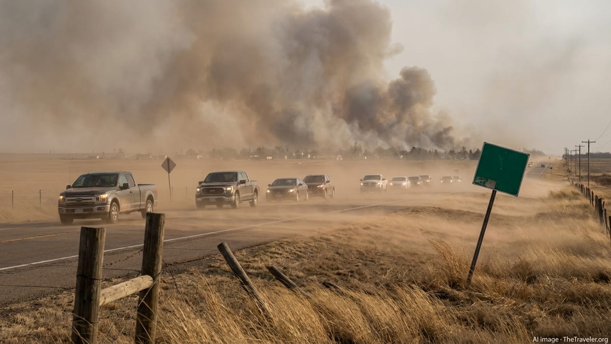
Evacuations, Highway Closures and a Growing Travel Toll
The fires have prompted a patchwork of evacuations and road closures that are reverberating through the regional travel network. Evacuation orders and recommendations have been issued in parts of Beaver, Texas and Woodward counties in Oklahoma, as well as communities in neighboring Kansas, where the Ranger Road Fire has jumped major routes and threatened small towns along the state line.
Sections of U.S. Highway 54 in the Oklahoma Panhandle were closed as the Stevens and Side Road fires advanced near Hooker and Tyrone, forcing traffic off one of the key east west corridors that links the region with Kansas and Texas. Farther north, the Ranger Road Fire crossed Kansas Highway 283 near Englewood and has been associated with additional impacts on Kansas Highways 160 and 183, limiting access to rural communities and disrupting freight movements across the High Plains.
Local officials in Woodward, a regional hub roughly 140 miles northwest of Oklahoma City, urged thousands of residents to voluntarily evacuate parts of the city as flames approached from the southwest. In some areas close to active fires, schools have shifted schedules, livestock operations have been disrupted and regional bus and shuttle services have been curtailed or rerouted to avoid low visibility and fast changing fire fronts.
Across the affected states, travelers are encountering sudden detours, extended driving times and limited services, particularly in smaller communities where motels and fuel stations are operating under smoke filled skies. Authorities are advising motorists to check road conditions frequently, prepare for potential closures with extra fuel and water, and avoid driving into active smoke plumes where visibility can drop to near zero in seconds.
Dust Storms and “Extremely Critical” Fire Weather in Multiple States
The wildfire emergency in Oklahoma and Kansas is unfolding against a broader backdrop of dangerous fire weather and dust storms stretching from Texas through Colorado and into Nebraska and New Mexico. The National Weather Service Storm Prediction Center issued an “extremely critical” fire weather outlook on February 17 for parts of eastern Colorado, southwestern Nebraska, western Kansas and the Texas and Oklahoma Panhandles, warning that any spark could lead to fast moving and destructive fires.
Across this region, sustained winds in the range of 25 to 40 miles per hour, low relative humidity and unseasonably warm temperatures more typical of late spring than mid February have created ideal conditions for rapid fire spread. Local National Weather Service offices from Amarillo and Pueblo to Hastings and Albuquerque have posted Red Flag Warnings, placing large swaths of the southern and central Plains under heightened alert for explosive fire growth.
In southeastern Colorado, transportation officials have issued a travel advisory highlighting hazardous conditions from high winds and blowing dust. Authorities warn that proactive safety closures are possible on key corridors such as Interstate 25 south of Pueblo and U.S. 287 south of Lamar, where brownout conditions can suddenly obliterate visibility. Drivers have been cautioned that strong crosswinds and dust can make travel treacherous, particularly for high profile vehicles and trucks hauling trailers.
Similar weather patterns extend across western Kansas, the Texas Panhandle and parts of Nebraska, where dust storms can accompany or follow wildfire outbreaks, spreading smoke and fine particles hundreds of miles downwind. For airlines serving regional airports in places like Amarillo, Garden City and Pueblo, periods of reduced visibility and shifting winds have the potential to cause delays, diversions and occasional cancellations.
Travel Hazards: From Brownouts to Runway Smoke
For motorists and travelers, the combination of wildfire smoke and dust storms presents a complex set of hazards that can change by the hour. In open rangeland, strong winds can suddenly lift walls of dust and debris several thousand feet high, racing across highways and creating near whiteout conditions often referred to locally as brownouts. Safety officials caution that drivers may have little or no warning before visibility plunges, making multi vehicle collisions a serious risk.
Transportation departments in Colorado, Kansas, Oklahoma and Texas are urging travelers to avoid driving directly into visible dust walls or dense smoke. Recommended tactics include reducing speed early, exiting highways where possible, pulling completely off the paved roadway and turning off headlights and hazard lights while stopped so that other drivers do not inadvertently follow tail lights into parked vehicles. Motorists are also being reminded to secure loose cargo and be prepared for sudden wind gusts that can push vehicles across lanes, especially on exposed bridges and overpasses.
At smaller regional airports scattered across the High Plains, thick smoke plumes from nearby wildfires can temporarily reduce visibility around runways and taxiways, while turbulent low level winds complicate approaches and departures. Although major hub airports in Denver, Dallas and Houston remain well outside the current fire zones, their feeder routes from smaller communities may experience intermittent disruptions as pilots and air traffic controllers work around smoke layers and shifting wind patterns.
Rail freight operators are likewise monitoring conditions along key north south and east west lines that traverse the affected states. Wildfire threats near tracks, combined with blowing dust and reduced visibility, can slow train movements or require temporary halts, adding another layer of complexity to the flow of goods through a corridor that is critical for agricultural exports, energy shipments and consumer supply chains.
Tourism, Outdoor Recreation and Rural Destinations Under Strain
The timing of these fires and dust storms is particularly disruptive for rural destinations that depend on winter and early spring travel. In parts of western Oklahoma, the Panhandles and southwest Kansas, small communities that cater to hunters, bird watchers and road trippers exploring historic byways are now contending with smoke filled skies, closed backroads and stressed infrastructure.
Popular driving routes that connect travelers to state parks, wildlife refuges and scenic prairies have seen intermittent closures, reducing access just as mild temperatures would normally encourage outdoor recreation. In southeastern Colorado and western Kansas, outfits that offer winter hiking, horseback riding and heritage tours are fielding cancellations and rebookings as visitors reconsider itineraries in light of volatile weather and fire conditions.
Ranch stays, small lodges and independently owned motels across the region are reporting a mix of guests: some travelers who are stranded by closures and others, including displaced residents and fire crews, seeking emergency lodging. This can strain local accommodation capacity in towns that are already limited in the number of available rooms, particularly when evacuations are ordered with little notice.
At the same time, civic leaders and tourism boards are walking a fine line between public safety messaging and long term destination stewardship. While urging travelers to heed official warnings, they are also emphasizing that conditions vary greatly from county to county and can improve quickly when winds shift or fires are contained. For many remote communities, ensuring that prospective visitors understand the localized nature of the crisis is essential for recovery once the immediate danger passes.
Climate Signals and an Unsettled Winter for Travelers
The current wildfire and dust storm outbreak is part of a broader pattern of weather extremes that has defined the winter of 2025 to 2026 across much of North America. Only weeks ago, a powerful winter storm buried a large swath of the country from Texas to Maine under deep snow and ice, causing more than a million power outages and widespread travel disruption. Now, abnormally warm, dry and windy conditions are driving fire weather in many of the same states.
Meteorologists note that temperatures across parts of Texas, Oklahoma and Colorado have been running as much as 25 degrees above seasonal averages during some recent periods, turning dormant winter grasses into ready fuel. Red Flag Warnings have lit up weather maps from New Mexico to Nebraska, highlighting how shifting climate patterns are compressing seasons and increasing the overlap between what used to be distinct winter, fire and severe storm periods.
For the travel sector, that means a more complex risk landscape in which traditional planning assumptions no longer always hold. Winter road trips across the Plains can now involve not only snow and ice but also wildfire smoke and dust storms. Airlines and rail operators must be prepared to pivot rapidly between managing deicing operations one week and rerouting around fire zones and visibility hazards the next.
Travel insurers, corporate travel managers and tour operators are also beginning to adapt to a world where weather related cancellations and disruptions are less predictable and more varied. Policies and contingency plans increasingly need to account for compounding risks such as back to back winter storms and wildfire events, even within the same month and region.
Advice for Travelers Crossing the High Plains Corridor
For travelers with near term plans that involve driving or flying through Oklahoma, Texas, Kansas, Nebraska, Colorado or neighboring states, experts stress the importance of flexibility and preparedness. Those planning road trips across the southern and central Plains are advised to monitor official advisories from state transportation departments and local emergency managers closely, especially if routes pass near the Oklahoma Panhandle, western Kansas or the southeastern plains of Colorado.
Travel planners recommend allowing extra time for detours, carrying additional water and fuel in remote stretches, and checking conditions multiple times per day, since closures can occur with little warning when wind shifts push fire fronts toward highways or when dust storms develop. Visitors with respiratory conditions should pay particular attention to air quality reports, as smoke and dust can aggravate health issues even at considerable distances from active fire lines.
For those flying in and out of regional airports across the High Plains, choosing morning departures can sometimes reduce exposure to afternoon peak winds and higher fire weather conditions, though this is highly dependent on local forecasts. When booking connections through major hubs, opting for slightly longer layovers may provide a buffer against knock on delays from smaller feeder routes affected by smoke or dust.
Above all, authorities emphasize that travelers should avoid attempting to outrun advancing fires or driving into known dust walls, as conditions can deteriorate far faster than expected. Respecting closures, following detour signage and staying informed through official channels are critical steps both for personal safety and for ensuring that emergency crews can focus on fire suppression and evacuations without additional incidents on the road network.