
More news on this day
Chicago-area travelers are facing rapidly deteriorating conditions this afternoon as a powerful spring storm moves into northern Illinois, bringing a wind advisory, the potential for severe thunderstorms and a risk of tornado warnings during peak travel hours.
Get the latest news straight to your inbox!
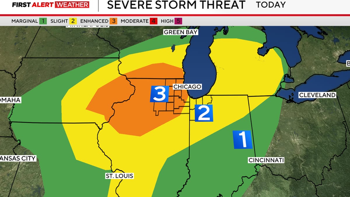
Image by CBS News
Wind Advisory Covers Much of Metro Chicago
Publicly available forecasts show a broad wind advisory in effect across most of the Chicago metropolitan area on Thursday, April 2, with peak gusts expected to reach 45 to 50 miles per hour from late morning through early evening. The advisory spans northeast Illinois and northwest Indiana, including Chicago, its close-in suburbs and key transportation corridors.
Reports indicate that the strongest winds are expected during the afternoon as the storm system intensifies over the Midwest. Southwest winds are projected to increase quickly, producing crosswinds that can affect high-profile vehicles on expressways and elevated stretches of interstate around the city.
Local coverage from television meteorologists and regional weather briefings note that these wind speeds are sufficient to bring down small branches, scatter unsecured outdoor items and create minor power interruptions, particularly where tree limbs are close to overhead lines. Travelers passing through residential neighborhoods may encounter debris on side streets and alleyways as gusts peak.
At Chicago’s lakefront, strong onshore and crosswinds can create choppy conditions and hazardous waves for small craft. Recreational boaters and lakefront walkers are being advised in public messaging to monitor conditions closely as the advisory remains in effect into the evening.
Severe Storms and Tornado Risk Building Through Afternoon
The same storm system driving the wind advisory is also fueling an increasingly unstable atmosphere over northern Illinois. Forecast discussions and regional outlooks point to multiple rounds of thunderstorms developing through the afternoon and evening, some of which could become severe and prompt tornado warnings.
Published outlooks from national forecast centers place much of northern Illinois, including the Chicago area, under an enhanced risk category for severe storms, a midlevel rating on the standard five-step scale. This classification reflects a higher-than-average likelihood of damaging winds, large hail and isolated tornadoes within the risk area.
Short-range forecast models highlighted in local coverage suggest that isolated supercell thunderstorms could form after midafternoon, with the most intense activity possible between roughly 3 p.m. and 9 p.m. As these storms mature, they may be capable of producing brief tornadoes, especially west and southwest of the city, before shifting toward the metro area near the evening commute.
Even in locations that avoid tornado warnings, the combination of straight-line wind gusts from thunderstorms and the broader gradient winds around the low-pressure system may create hazardous conditions. Sudden reductions in visibility from torrential rain, along with hail in the stronger cells, could challenge drivers and pedestrians moving through downtown and neighborhood commercial districts.
Impacts on Air, Rail and Road Travel
For those passing through Chicago’s airports, the timing of the storms is particularly sensitive. Aviation-focused forecasts referenced in local reports indicate that the worst of the weather may overlap with the busy late-afternoon and early-evening bank of flights at O’Hare International Airport and Midway International Airport.
Strong surface winds and low cloud ceilings associated with thunderstorms can contribute to ground delays, flow restrictions and occasional diversions. While individual airlines and airport authorities manage responses in real time, travelers are being encouraged through public advisories to check the latest status of departures and arrivals and to allow additional time for security and boarding.
On the ground, high-profile vehicles on stretches of Interstates 55, 57, 80, 88, 90 and 94 could experience buffeting from crosswinds, especially on elevated sections and open corridors south and west of downtown. Travel briefings for northern Illinois highlight an increased risk for rollover incidents involving trucks and trailers in exposed areas during the strongest gusts.
Commuter rail and intercity services may also feel indirect effects. Intense thunderstorms can sometimes lead to temporary slow orders because of debris on tracks, localized flooding near low-lying rail beds or power interruptions affecting signals. Travelers using Metra, Amtrak or regional bus services are being urged in public-facing information to monitor service alerts as storms approach.
Storm Timing, Flooding Concerns and Weekend Outlook
Forecasts compiled from several outlets indicate that initial showers and storms are likely to increase in coverage through the early afternoon, with more organized severe storms developing later in the day as a cold front draws closer. Some models suggest multiple waves of storms, beginning with more isolated cells followed by a broader line of thunderstorms during the evening.
Rainfall rates in the strongest storms could be intense, raising concerns about ponding on roadways and minor flash flooding in urban locations with poor drainage. Coverage from Chicago-based news organizations notes that freeway ramps, viaducts and underpasses that are prone to water accumulation may become temporarily impassable during peak downpours.
Storm chances may not end with the first round. Outlooks referenced in regional briefings point to additional opportunities for showers and thunderstorms on Friday and into Saturday as the broader system slowly exits the Great Lakes. While the precise timing and intensity of later storms remain less certain, the pattern suggests an unsettled start to the weekend for those transiting through Chicago.
By Sunday and early next week, forecast discussions indicate a shift toward drier and cooler conditions, with more seasonable temperatures and lower humidity. For travelers, that would bring a more favorable window for arrivals, departures and road trips through Chicago after several days of active and at times disruptive weather.
What Travelers Should Watch as Conditions Evolve
Emergency management guidance for Illinois historically emphasizes the importance of having multiple ways to receive weather information during rapidly changing severe weather situations. For visitors and those passing through the Chicago area, this approach is especially important on a day when conditions could shift quickly from breezy and warm to stormy with tornado warnings in a matter of hours.
Travelers are being encouraged through widely shared preparedness materials to stay alert to watches and warnings, avoid relying solely on outdoor sirens and consider where they would take shelter if a tornado warning were issued while they are in a hotel, terminal or vehicle. Interior rooms on lower floors, away from windows, are typically recommended as safer options in large buildings.
Public safety campaigns in Illinois also highlight simple steps that can reduce risk during severe weather, such as keeping mobile devices charged, securing loose outdoor objects and avoiding flooded roadways. These measures can be particularly useful for those unfamiliar with local flood-prone routes or neighborhood drainage patterns.
For travelers with flexible schedules, some may opt to adjust departure or arrival times to avoid the projected peak of severe storms late this afternoon and evening. For others whose plans cannot shift, staying closely tuned to official forecasts and transportation updates throughout the day remains the best strategy as the wind advisory and severe weather threat unfold over the Chicago region.