
More news on this day
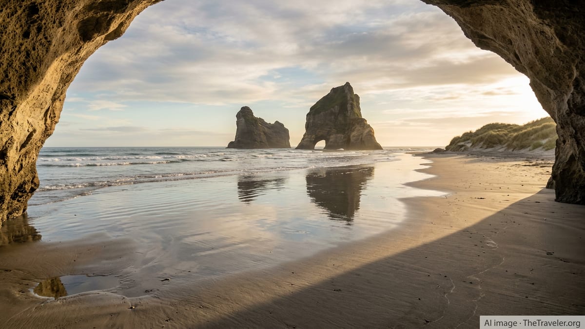
For millions of Windows users, the view is instantly familiar: golden light spilling from a sea cave onto wet sand, rock arches rising from a glassy tide. What many do not realize is that this is not a digital fantasy but Wharariki Beach, a remarkably remote strip of coastline on New Zealand’s South Island that has become world famous without most viewers knowing its name.
Get the latest news straight to your inbox!
The Real Beach Behind a Global Screensaver
Publicly available information identifies Wharariki Beach, near Cape Farewell at the northern tip of New Zealand’s South Island, as the location used for one of the most widely seen Windows 10 lock screen images. The scene shows part of the Archway Islands, a small group of rocky islets just offshore, reflected in the wet sand at low tide.
Coverage of the destination indicates that the beach remained relatively little known internationally until around 2015, when Windows 10 brought the image to home and office computers worldwide. Since then, travel articles, user forums and photography sites have repeatedly linked the lock screen view to Wharariki, solidifying its association with the operating system.
The composition is distinctive enough that visitors who later travel to New Zealand often report recognizing the place as soon as they step onto the sand. The curve of the cave, the angle of the light and the silhouettes of the rock arches match what has become one of the most recognizable digital landscapes of the past decade.
Unlike a computer graphic, however, the real beach is shaped by tides, winds and shifting weather. The reflections that appear perfectly polished on screen are created each day as the Tasman Sea recedes, leaving a thin mirror of water over the sand in front of the islands.
A Remote Corner of New Zealand’s South Island
Wharariki Beach lies west of Cape Farewell in the Tasman District’s Golden Bay region, backed by rolling farmland and coastal forest and facing directly onto the Tasman Sea. Maps and tourism information show that it sits close to the boundary of Kahurangi National Park and near Puponga Farm Park, an area known for walking tracks and rugged headlands.
Reaching the beach involves more effort than a typical roadside viewpoint. Most guidance for visitors describes a 15 to 20 minute walk from the end of Wharariki Road, following farm tracks and sandy paths through pasture and pockets of coastal bush before the landscape opens suddenly onto dunes and sea.
The area is sparsely populated, with the small settlement of Puponga several kilometres away and the larger service town of Takaka more than an hour’s drive over a steep mountain pass. This relative isolation helps explain why the beach itself remained outside mainstream tourism circuits even as its image quietly circulated on millions of devices.
On site, the surroundings feel far wilder than a typical postcard destination. Winds can be strong, surf often heavy and weather conditions changeable, especially in winter. Visitors are generally advised to come prepared for exposed coastal conditions despite the tranquil mood suggested by the screensaver image.
Archway Islands, Sea Caves and Shifting Sand Dunes
The rock formations that feature so prominently in the Windows lock screen are part of the Archway Islands, a cluster of sea stacks and small islets that sit either on or just off the beach. Descriptions in guidebooks and destination profiles highlight these arches as the defining feature of Wharariki’s skyline, rising sharply from the surf and catching soft light at sunrise and sunset.
At low tide, broad sheets of firm sand stretch out toward the islands, creating the reflective surface that gives the famous image its mirror-like effect. Photographers often time their visits to coincide with these conditions, when a thin layer of water lingers over the beach and amplifies the symmetry of rock, sky and cloud.
Behind the main shore, extensive sand dunes roll inland, constantly reshaped by prevailing winds. Paths weave between sculpted ridges and pockets of coastal vegetation, and visitors frequently note how the dunes create a sense of seclusion even when others are on the beach.
The area is also known for wildlife. Reports indicate that New Zealand fur seals sometimes haul out along the coastline, and shallow pools near the rocks can become play areas for seal pups in summer. Local guidelines typically stress keeping a respectful distance from animals and avoiding disturbance, particularly during breeding periods.
From Anonymous Coastline to Global Visual Icon
Before its appearance on Windows 10, Wharariki Beach was familiar mainly to local residents, domestic travellers and landscape photographers who sought out remote locations. Tourism features from the early 2010s describe it as a rugged, uncrowded alternative to New Zealand’s more famous coastal stops.
Its transformation into a global visual icon came when Microsoft selected imagery of the beach for use as a default lock screen and wallpaper within Windows 10, first released in 2015. Technology coverage and travel reporting have since traced the now-ubiquitous image back to Wharariki, comparing its ascent to that of the earlier Windows XP “Bliss” hillside in California.
Unlike “Bliss,” however, which depicts a gently rolling pastoral scene, the Wharariki view emphasizes wildness: sharp silhouettes, exposed rock and the suggestion of an open ocean stretching beyond the frame. This contrast has helped shape international perceptions of New Zealand as a place of dramatic, untamed coastlines.
The connection between software and scenery has also influenced travel choices. Online discussions show some visitors planning detours to Golden Bay specifically to seek out the Windows lock screen location, treating the beach as a kind of real-world Easter egg hidden within their operating system.
Planning a Visit to the Famous Windows Beach
For prospective travellers, practical details point to a destination that remains relatively low key despite its digital fame. The access track is unpaved in parts, the final road section is narrow and there are no shops or services directly at the beach, so visitors typically base themselves in nearby Golden Bay towns and drive in for day trips.
Travel information commonly recommends checking tide charts before setting out, as the most recognisable reflections occur near low tide and some sections of the beach are more constrained when the sea is high. Strong winds and blowing sand are also frequent, particularly in the afternoon, so protective clothing and secure storage for camera gear are considered useful.
Conservation messaging in the region emphasizes staying on marked paths where possible, avoiding fragile dune plants and keeping a safe distance from wildlife. As awareness of Wharariki’s global profile increases, local tourism providers and park managers highlight the importance of balancing visitor interest with the protection of a sensitive coastal environment.
For those who make the journey, the reward is the chance to stand inside a view that has long existed only on a screen, watching the same light shift across the Archway Islands in real time. In place of a silent lock screen, there is the sound of surf, wind through the dunes and, on many days, far fewer people than its worldwide familiarity might suggest.