
More news on this day
A sprawling late-winter storm linked to a broader North American weather system is striking northern Michigan with heavy snow, ice and fierce winds, triggering travel disruptions, widespread power outages and warnings of increasingly hazardous conditions through Monday.
Get the latest news straight to your inbox!
Blizzard Conditions and Ice Create Treacherous Roads
Publicly available weather analyses describe the storm as part of a large extratropical cyclone that formed on March 13 and is impacting much of the central United States and southern Canada with blizzard conditions, severe thunderstorms and an ice storm focused on northern Michigan. In the northern Lower Peninsula and Upper Peninsula, the cold side of the system is producing intense snowfall, blowing and drifting snow, and pockets of freezing rain that are rapidly reducing visibility and coating surfaces in ice.
National forecast discussions and radar imagery show bands of heavy snow pivoting across the eastern Upper Peninsula and the higher terrain of the western and central Upper Peninsula, with snowfall rates high enough at times to overwhelm plowing efforts. In some favored lake-effect and upslope areas, early reports indicate snow totals already in the double digits, with more expected as the storm continues to wrap moisture into the region.
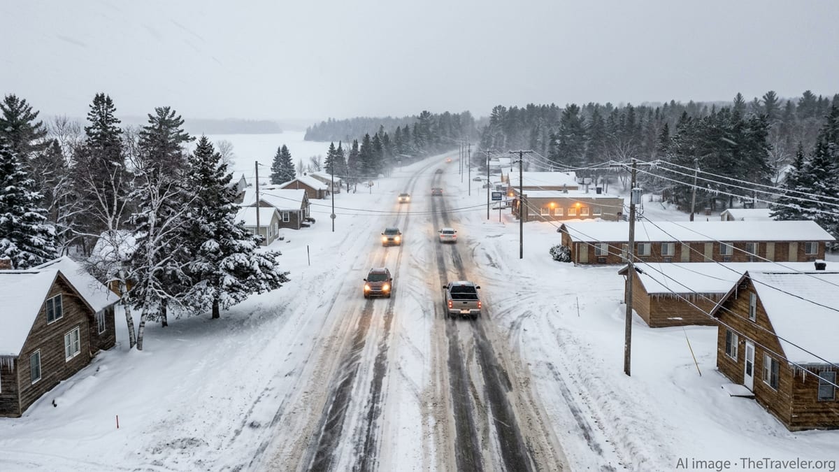
Travel bulletins and regional alerts warn that roads ranging from smaller county routes to stretches of US and state highways are quickly becoming snow covered, rutted and icy. Blowing snow is creating whiteout conditions in open country, especially along exposed shoreline corridors of Lake Superior and inland highlands, where strong gusts are driving snow across roadways and obscuring lane markings.
Social media posts and local coverage from communities in the Upper Peninsula describe motorists abandoning vehicles in ditches, jackknifed trucks and extended response times for roadside assistance. Transportation updates emphasize that conditions are deteriorating most rapidly after dark, when plunging temperatures are turning slush into glare ice beneath fresh snow.
Warnings, Closures and Calls to Avoid Nonessential Travel
Regional forecast offices have issued an array of winter storm warnings, blizzard warnings and winter weather advisories across northern Michigan, highlighting the risk of life-threatening travel conditions. These alerts, updated through Sunday night, call out the combined threat of heavy snow, strong winds and ice accumulation on trees, power lines and exposed infrastructure.
Publicly available information from local institutions shows that major campuses in the western Upper Peninsula, including Michigan Technological University, have preemptively closed offices and in-person activities on Sunday and Monday in response to the storm forecast. Messages circulated to students and staff urge residents to remain off the roads, stock essential supplies and prepare for extended outages.
County-level emergency management plans and recent hazard assessments for northern Michigan reference similar March storms in recent years that produced multi-day closures, stranded travelers and difficult access for emergency services. In light of those experiences, local advisories are now strongly recommending that residents complete any essential errands early and then avoid all nonessential travel for the duration of the event.
Travel information shared by state and county road agencies notes that plow crews are prioritizing primary routes but may be forced to pull back temporarily if visibility falls to near zero or if wind gusts exceed safe operating thresholds. Drivers who choose to travel are being warned to anticipate rapidly changing conditions along the same route, with sections of bare pavement giving way suddenly to deep drifts and ice-glazed bridges.
Power Outages Spread as Heavy, Wet Snow and Ice Hit the Grid
Outage tracking services and utility dashboards show that northern Michigan is experiencing a growing number of power cuts as the storm intensifies. Early Sunday figures indicate tens of thousands of customers without electricity across the northern Lower Peninsula and Upper Peninsula, with the potential for outage totals to rise as heavy, wet snow and ice continue to accumulate on tree limbs and distribution lines.
Recent state energy appraisals and after-action reviews of past northern Michigan ice and snow events emphasize that the region’s heavily forested landscape and long radial feeder lines make rural communities particularly vulnerable to prolonged outages. Those reports document previous late-March storms in which ice loads brought down extensive segments of the grid, leaving some households without service for days or longer while crews navigated blocked roads and deep snow.
Early reports from residents on public forums in affected communities describe transformers arcing in high winds, trees snapping under the weight of ice and the sound of limbs striking rooftops and vehicles. In coastal and island communities along Lake Superior and northern Lake Michigan, where access is limited, outages are raising added concerns about heating, communications and the ability of ferries or emergency flights to operate reliably.
Utilities’ public-facing updates are highlighting the difficulty of safe restoration work during the height of the storm, particularly while strong gusts persist and roads remain partially impassable. Customers are being urged, through widely shared safety guidance, to assume all downed wires are energized and to report hazards from a safe distance rather than attempting any direct intervention.
Air and Road Travel Ripple Effects Across the Region
The storm’s impacts extend beyond local roads, with regional and national travel systems also feeling the strain. Flight status boards and airline advisories for key Michigan gateways show cascading delays and cancellations for routes connecting northern Michigan airports with Detroit and Chicago hubs, as airlines adjust schedules in response to crosswinds, low visibility and ground handling challenges.
Highway travel across the broader Great Lakes region is also being reshaped as the storm continues to evolve. While northern Michigan contends with blizzard and ice conditions, southern parts of the state and neighboring regions are experiencing high winds and heavy rain tied to the same weather system. This sharp gradient in conditions is resulting in a patchwork of road advisories, from icy bridges in the north to wind-related high-profile vehicle restrictions farther south.
Travel industry observers and transportation-focused news coverage point out that the timing of the storm, arriving over a March weekend, is disrupting late-winter tourism and end-of-term campus travel. Ski areas and outdoor destinations that depend on reliable weekend access are seeing reservations canceled or rebooked, while bus and shuttle operators serving college towns are adjusting departures around evolving road conditions.
Given the interconnected nature of airline and highway networks, delays in northern Michigan are also contributing to knock-on effects at more distant airports and logistics hubs. Airlines and carriers are encouraging travelers to check the latest status of flights and routes and to build extra time into itineraries, especially for connections involving smaller regional airports.
Residents Brace for a Prolonged, Multi-Day Event
Forecast discussions indicate that the storm will remain slow-moving, with periods of heavy snow, mixed precipitation and strong winds likely to continue into Monday across much of northern Michigan. Snow totals are expected to climb steadily, particularly in higher elevations and along the Lake Superior snow belts, while wind chills drop and drifting intensifies.
Emergency preparedness guidance shared widely in the region is urging households to plan for the possibility of being homebound for at least 24 to 48 hours. Recommended steps include charging mobile devices, securing an adequate supply of food, water and prescription medications, and ensuring that alternative heat sources and backup power systems are ready and safe to operate.
Community discussions in northern Michigan, especially in areas that endured significant ice and snow events in recent years, reflect a mix of fatigue and resilience. Residents are trading information on functioning gas stations, grocery store hours, and which neighborhoods have lost power, while also sharing advice on staying warm in older homes, clearing roof loads safely and checking on neighbors who may be more vulnerable.
As the storm continues to unfold, publicly available weather information suggests that conditions will gradually improve from west to east once the core of the system lifts out of the Great Lakes. For now, however, northern Michigan remains in the grip of a powerful late-winter blast that is testing transportation networks, energy infrastructure and community preparedness at a time of year when many hoped the worst of winter was already in the rearview mirror.