
More news on this day
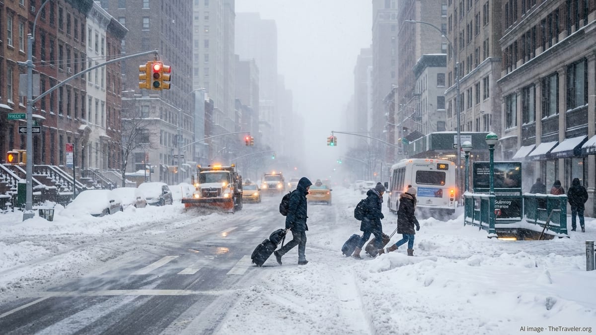
Winter Storm Hernando is battering the Northeast United States today with blizzard conditions, forecast totals of up to 24 inches of snow, and mounting travel chaos across New York, Boston, Philadelphia, and the broader Interstate 95 corridor, prompting urgent warnings to travelers to delay or reroute their journeys.
Blizzard Conditions and a Rapidly Deepening Nor’easter
A sprawling coastal storm evolving into a powerful nor’easter is rapidly intensifying off the Eastern Seaboard on Sunday, February 22, transforming into what forecasters describe as a bomb cyclone as it tracks northward parallel to the coast. The system, unofficially named Winter Storm Hernando by The Weather Channel, is drawing frigid Arctic air into a moist Atlantic feed, creating a classic setup for a historic snowstorm from the mid-Atlantic to New England.
Blizzard warnings are in effect for major population centers including New York City and Boston, where forecasters anticipate whiteout conditions, dangerous wind gusts, and heavy, wet snow through late Sunday and into Monday. The February 2026 nor’easter is expected to drop as much as two feet of snow across parts of the Northeast megalopolis, with localized totals near 24 inches possible in bands of intense snowfall.
Along the I-95 corridor, from Philadelphia through New York to Boston, snow is forecast to fall at rates of 1 to 2 inches per hour during the height of the storm. Coupled with gusts that could top 50 to 55 miles per hour along the coast, visibility will periodically drop to near zero, making road travel treacherous and, in some areas, nearly impossible. Coastal communities are also bracing for minor to moderate coastal flooding and beach erosion as strong onshore winds push water toward the shoreline.
Meteorologists note that Hernando follows weeks of volatile winter weather driven in part by a disrupted polar vortex and a strong subtropical jet stream, a pattern that has funneled disturbances across the country before they intensify along the warm waters of the western Atlantic. This latest storm is projected to be one of the most disruptive of the 2025–26 winter season, striking at the close of the February travel period when airports and highways are normally busy with weekend and business travelers.
Historic Snowfall Totals Target New York, Boston, and Philadelphia
Forecasters warn that Hernando could deliver some of the heaviest snowfall totals in nearly a decade for several Northeast cities. New York City is under a blizzard warning for the first time since 2017, with early projections placing snowfall totals between 12 and 20 inches across the five boroughs, and the potential for localized amounts up to 24 inches where the most intense snow bands linger. Central Park, the city’s benchmark observing site, may see one of its largest single-storm accumulations of recent winters.
Boston is also under a rare blizzard warning, its first since January 2022, with expected totals in the 18 to 24 inch range as the storm’s comma-shaped precipitation shield pivots overhead. Strong northeasterly winds off Massachusetts Bay are expected to enhance snowfall, especially along the South Shore and into Cape Ann, where heavy, wind-driven snow will reduce visibility to a fraction of a mile for extended periods.
In Philadelphia, forecasters anticipate a sharp gradient between heavier coastal snow and lighter inland amounts, but the metro region is still preparing for a high-impact event. The city and nearby suburbs could see 8 to 14 inches of snow, with higher totals possible northeast of the urban core toward central New Jersey. Even where snowfall amounts fall short of two feet, a combination of heavy, wet snow and wind will be enough to down branches and power lines and cause dangerous travel conditions.
Across the broader region, from eastern Pennsylvania and New Jersey to southern New England, many communities have declared snow emergencies, restricted on-street parking, and mobilized fleets of plows and salt spreaders. Officials caution that even with aggressive preparation, the intensity and duration of Hernando’s snowfall may outpace the ability of crews to keep up, especially during the peak of the storm Sunday afternoon and Sunday night.
Air Travel Meltdown: Thousands of Flights Canceled
Air travel has emerged as one of the earliest and most visible casualties of Winter Storm Hernando. Airlines began preemptively trimming schedules on Saturday, and by Sunday morning more than three thousand flights had been canceled or delayed across the Northeast, with the largest impacts concentrated at the New York, Boston, and Philadelphia hubs.
New York’s three major airports, John F. Kennedy International, LaGuardia, and Newark Liberty, are experiencing widespread disruptions as heavy snow, gusty crosswinds, and low visibility reduce arrival and departure rates. Major carriers have grounded large portions of their Sunday and Monday operations at these airports, with additional cancellations expected as conditions deteriorate into full blizzard status. Similar scenes are unfolding at Boston Logan International Airport, where long lines at customer service counters and packed terminal seating areas reflect a wave of stranded travelers.
Airlines including Delta, United, American, and JetBlue have issued weather waivers for affected airports, allowing passengers to change itineraries without standard change fees or fare differences within defined travel windows. Delta, for example, has canceled flights in and out of its Boston and New York hubs and is encouraging customers to rebook for later in the week. Carriers stress that safety remains the primary concern and that crews cannot operate when runways are snow covered and visibility falls below minimum thresholds.
Industry analysts say the ripple effects of Hernando will extend well beyond the Northeast. Aircraft and crew displaced by the storm will contribute to knock-on delays and cancellations at airports as far away as Atlanta, Chicago, and Dallas, even where weather conditions are fair. Travelers are being advised to treat any itinerary involving a connection through the Northeast as highly vulnerable to disruption for at least 48 to 72 hours.
On the Ground: Hazardous Roads and Transit Disruptions
On the ground, states from Pennsylvania and New Jersey to New York and Massachusetts have activated winter storm plans and emergency operations centers. Transportation departments have pre-treated interstates and primary highways, but officials emphasize that no amount of salt can prevent snow from quickly covering surfaces when accumulation rates top an inch per hour. Motorists along key routes such as I-95, I-78, I-80, and the Massachusetts Turnpike are seeing visibility drop rapidly as the heaviest bands move inland from the coast.
In New York City, Mayor Zohran Mamdani has urged residents to stay home and avoid any nonessential travel, saying that empty roads are critical for snowplows, emergency vehicles, and utility crews. The city has deployed thousands of sanitation workers in staggered shifts and has readied a vast fleet of plows and salt spreaders to work through the night. Many bridges and elevated roadways are expected to become slick and hazardous earlier than surface streets due to wind and exposure.
Philadelphia has declared a code blue, opening additional warming centers for the unhoused population as temperatures plunge below freezing and winds increase. Local officials have implemented vehicle restrictions on certain highways, including bans on empty tractor-trailers and other high-profile vehicles vulnerable to strong crosswinds. Several suburban counties have upped staffing at 911 centers, anticipating an influx of accidents, disabled vehicles, and calls for welfare checks as the storm deepens.
Public transit systems from New Jersey Transit and the Long Island Rail Road to the MBTA around Boston are warning riders of reduced service, delays, and potential suspensions of above-ground lines if snow and wind reach forecast levels. Commuter rail agencies have staged snow-fighting equipment and work crews along key corridors, but note that drifts and downed branches can quickly block tracks. Many cities have also suspended or limited above-ground light rail and bus operations on hilly routes where traction is a concern.
States of Emergency and Coastal Communities on Alert
Governors across the Northeast have declared states of emergency ahead of Hernando’s arrival, unlocking additional resources and funding to support local response efforts. New Jersey, New York, and several New England states have activated National Guard units to assist with everything from clearing snow around hospitals and critical infrastructure to evacuating residents in low-lying coastal areas vulnerable to flooding.
Along the Jersey Shore, Long Island’s South Shore, and coastal New England, communities are bracing for a combination of storm surge, high tides, and large waves driven by persistent onshore winds. While Hernando’s primary impact is heavy snow, even moderate coastal flooding could inundate roads, damage dunes, and complicate access routes for emergency services. Residents in flood-prone neighborhoods are moving vehicles to higher ground and securing outdoor equipment as water levels begin to rise with each successive high tide.
Emergency management agencies are emphasizing the interplay between snow, wind, and cold in driving risk. Power outages resulting from downed lines and tree limbs could leave households in the dark and cold for hours or days, particularly in more rural areas where crews require more time to reach damaged infrastructure. Officials urge residents to prepare for the possibility of temporary loss of heat by stocking blankets, warm clothing, and sufficient food and water.
Hospitals and care facilities in the storm’s path have dusted off severe weather plans, securing extra staff to stay overnight, arranging four-wheel-drive transportation for critical workers, and checking backup generators. In coastal resort towns that typically see quieter winters, hotels are hosting utility crews, linemen, and emergency staff, turning seasonal tourist accommodations into logistical hubs for storm response.
How Travelers Can Minimize Risk and Disruption
Given the breadth and severity of Winter Storm Hernando’s impacts, travel experts and emergency officials are united in one message: if you can postpone your trip, do so. For those who must travel, advanced preparation can significantly reduce risks. Air travelers are urged to proactively check their flight status before leaving for the airport, rebook to later dates when possible, and avoid tight connections that rely on Northeast hubs.
Passengers already at airports in New York, Boston, or Philadelphia should expect extended waits at customer service counters and limited same-day options. Travel advisors recommend using airline mobile apps to manage rebookings and seeking vouchers for meals and accommodation when overnight delays occur, although policies vary by carrier and the classification of the disruption as weather-related. Travelers who purchased trip insurance should review coverage details, as many policies include provisions for severe weather that makes travel impossible or unsafe.
For those on the roads, officials advise carrying a fully charged phone, extra warm layers, water, and nonperishable snacks in case of unexpected delays or strandings. Drivers are reminded to keep gas tanks at least half full to prevent fuel line freeze-up and to allow vehicles to idle for warmth if caught in a prolonged backup. In blizzard conditions, pulling off onto the shoulder can create hazards for plows and emergency vehicles, so motorists are urged to exit highways and seek safe parking areas if driving becomes untenable.
Rail and bus passengers should verify schedules directly with operators, as service may be curtailed or suspended altogether during the worst of the storm. Some intercity operators have already canceled routes in and out of New York and Boston, while others are operating reduced timetables to minimize the risk of trains becoming stranded between stations. Flexible tickets and no-penalty changes are increasingly common during major winter events, and riders are encouraged to take advantage of those options.
Looking Ahead: Storm Timeline and Recovery Outlook
Forecast models suggest that the heaviest snow associated with Winter Storm Hernando will continue through late Sunday night into Monday morning, with conditions gradually improving from southwest to northeast as the storm pulls away into the Gulf of Maine. For New York City and Philadelphia, the most intense phase of the storm is expected to taper early on Monday, though cleanup and residual delays will persist well into the workweek. Boston and coastal New England may see snow and strong winds linger longer as the low pressure center deepens offshore.
As skies clear, attention will rapidly shift from falling snow to the monumental cleanup effort. With accumulations approaching two feet in some locations, municipalities will face the task of clearing not only main arteries but also side streets, sidewalks, and transit hubs. Snow removal will be complicated by the heavy, moisture-laden character of the snow, which is more difficult to plow and more likely to cause structural stress on roofs, awnings, and older buildings if not removed.
Airlines will begin to rebuild schedules once runways are cleared, but experts caution that normal operations at major hubs may not fully resume for several days. Aircraft and crew positioning, mandatory rest requirements, and ongoing weather challenges elsewhere in the network mean that residual disruptions can linger even after blue skies return. Travelers holding tickets for early-week flights in and out of the Northeast are advised to monitor communications from their airlines closely and consider voluntary rebooking to midweek departures.
For residents, the aftermath of Hernando will bring familiar winter hazards: refreezing on untreated surfaces, falling ice from buildings, and the risk of roof collapses where snow loads exceed design limits. Authorities stress that while the storm itself may pass in a matter of hours, its impact on transportation, infrastructure, and daily life will endure much longer. Travelers planning to visit New York, Boston, Philadelphia, or nearby destinations in the coming days should expect a region still digging out, with patience and flexibility key to any successful trip.