
More news on this day
Winter Storm Iona is hammering large swaths of the United States with blizzard conditions, high winds and hazardous ice, sending the nation’s tightly wound air and ground transport systems into fresh turmoil just as spring travel demand surges.
Get the latest news straight to your inbox!
Blizzard Conditions Meet a Busy Spring Travel Rush
Winter Storm Iona, part of a sprawling March 13 to 17 storm complex, is bringing intense snow, whiteout conditions and pockets of damaging ice from the northern Rockies and Upper Midwest through the Great Lakes and into the Northeast. Publicly available data from the National Weather Service indicates that some communities in the Upper Midwest and High Plains are seeing snow measured in feet, combined with wind gusts strong enough to shut down long stretches of interstate highways and trigger scattered power outages.
The timing is especially disruptive. The storm is unfolding as spring break crowds, business travelers and fans heading to NCAA basketball tournaments are already filling airports and highways. According to published aviation tracking data, thousands of flights were canceled or delayed across the United States on Monday and Tuesday alone, with major hubs in Chicago, Atlanta and New York among the hardest hit as the storm’s impacts radiate outward through the national air network.
Reports from multiple airline and airport dashboards show that even regions outside the core snow and ice bands are feeling the effects. Aircraft and crew displaced by earlier cancellations are leaving carriers short of resources in otherwise clear-weather cities, creating rolling delays that can stretch for hours and complicate travel far beyond the immediate storm zone.
On the ground, transportation agencies are warning that rapidly changing conditions are making driving hazardous. Sections of interstate routes across the northern Plains and Upper Midwest have seen closures or severe restrictions as visibility drops and snowplows struggle to keep up with fast accumulations and drifting.
Airports Struggle With Cascading Cancellations
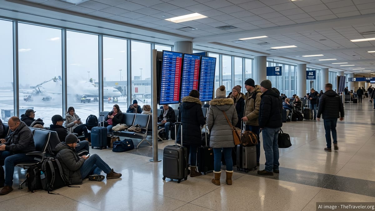
Major airports across the Midwest and East Coast are grappling with a second straight day of intense disruption. Flight-tracking services show more than a thousand cancellations on Tuesday, following nearly five thousand on Monday, as Iona’s snow and wind swept into key hubs from Minneapolis to Boston. The impacts overlap with an already stressed system shaped by earlier winter storms this season, leaving airlines with little slack to recover quickly.
Atlanta, Chicago O’Hare and New York area airports have emerged as persistent trouble spots, with hundreds of combined cancellations and delays rippling across domestic and international networks. Published coverage by national outlets describes crowded concourses, long customer service queues and travelers camping near gates after late-night cancellations, particularly where lodging near airports has quickly sold out or filled with stranded passengers.
In the Northeast, Iona’s wintry mix is arriving on the heels of February’s Blizzard of 2026, which previously shut down portions of New York, New Jersey and New England and produced one of the highest single-day tallies of weather-related flight cancellations since the pandemic era. Publicly accessible airline operations summaries indicate that carriers had only just restored more normal schedules from February’s disruption when Iona’s bands of snow and wind began to encroach on the region again.
Aviation analysts note in recent commentary that when storms strike major connecting hubs, airlines often resort to preemptive, large-scale schedule cuts in an effort to avoid trapped aircraft and crews. While this can reduce the risk of passengers being stuck on taxiways or in extended onboard delays, it also intensifies the short-term shock for travelers who suddenly learn that entire days of flights on popular routes have been wiped from the schedule.
Knock-On Impacts for Trains, Roads and International Links
Winter Storm Iona is not only affecting air travel. The same system bringing blizzard conditions to the Upper Midwest is driving bands of heavy rain, ice and strong winds into parts of the South and East Coast, complicating rail and highway travel. According to public timetables and service alerts, some intercity and regional rail operators have issued weather-related modifications, including shortened routes, slower speeds and targeted cancellations where snow, ice or downed trees are expected along the tracks.
Road agencies in multiple states are updating public advisories to urge drivers to avoid non-essential travel in the hardest hit areas, citing low visibility, icy pavement and the risk of rapidly forming snowdrifts. In urban corridors, the challenge is often less about sheer snow depth and more about slushy, refreezing surfaces that can quickly turn evening commutes into gridlock and increase the likelihood of fender benders and spinouts.
The effects are also being felt on some international routes. Earlier this season, long-haul carriers temporarily suspended or reduced select flights into East Coast gateways when other winter storms snarled airport operations and ground handling. With Iona now sweeping through many of the same regions, publicly available schedules show fresh adjustments, particularly on transatlantic and long-haul services that rely on precise timing and aircraft rotations.
Global freight flows are not immune either. Cargo operators and logistics firms have issued service advisories noting weather-related slowdowns at key airfreight hubs, along with ground delays as trucks face difficult driving conditions. For time-sensitive shipments, planners are working within narrower operating windows as they navigate runway braking limits, de-icing queues and highway closures linked to the storm.
What Travelers Can Expect in the Coming Days
Meteorological analyses indicate that Winter Storm Iona will continue to impact different parts of the United States through at least March 17, with conditions evolving as the core low-pressure system tracks east and gradually weakens. Even as skies begin to clear, the travel system is likely to remain unsettled. Aviation observers often describe a multi-day recovery period after a major weather shock, as airlines reposition aircraft and crews, work through backlogs of displaced passengers and rebuild normal rotations.
Publicly available airline notices show that many large carriers have issued weather waivers for affected regions, allowing customers to rebook without standard change fees during defined windows. Travelers who can postpone or adjust their plans may find it easier to secure seats later in the week, once operations stabilize. Those who choose to travel during the peak of Iona’s impacts should prepare for longer lines at check-in and security, extended waits for customer support and the possibility of last-minute gate or schedule changes.
Ground travelers can also expect lingering effects after the snow stops falling. Road crews will need time to clear accumulated snowbanks, address icy patches and remove debris. In some communities, localized flooding may develop as temperatures rise and rapid snowmelt begins, creating new hazards for drivers even as winter weather alerts expire.
For now, the combination of Winter Storm Iona’s reach, the already bruising 2025 to 2026 cold season and a busy spring travel period is testing travelers’ flexibility and the resilience of the broader U.S. transport network. Public forecasts and transportation alerts indicate that conditions will remain variable and, in some cases, severe, making advance planning and close monitoring of itineraries essential for anyone on the move.