
Niagara Falls is one of North America’s most accessible natural wonders, yet planning how to get there and move around smoothly still takes a bit of strategy. With two countries, several airports, multiple train and bus options, and distinct local transport systems on each side of the border, it is worth understanding your choices before you go. This guide brings together the latest information to help you reach Niagara Falls efficiently and navigate the area with confidence once you arrive.
Choosing Between the American and Canadian Sides
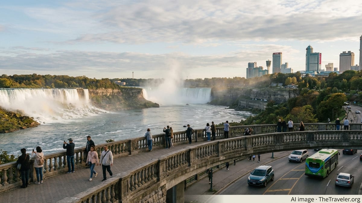
Niagara Falls straddles the border between New York State in the United States and the province of Ontario in Canada. Most visitors choose which side to base themselves on before they start booking transport, because it affects which airports, trains, buses, and local transit systems will work best. The American side centers on Niagara Falls State Park in Niagara Falls, New York, while the Canadian side focuses on Queen Victoria Park in Niagara Falls, Ontario. Travel between the two is straightforward for those who meet border requirements, but you should still plan with your primary side in mind.
In broad terms, the Canadian side offers the classic panoramic views of all three waterfalls, dense clusters of hotels in the Fallsview and Clifton Hill districts, and a well developed visitor transportation network. The American side provides more of a state park atmosphere, with trails, viewpoints and islands close to the water, plus easy access from Buffalo and other parts of upstate New York. Your arrival route will often be dictated by flight availability and fares, but understanding these differences can help you decide where to land and which border crossing, if any, you might use.
Crossing the border at Niagara Falls is usually done over one of several international bridges in the region, most famously the Rainbow Bridge between downtown Niagara Falls, New York and Niagara Falls, Ontario. The bridge accommodates vehicles, cyclists, and pedestrians and typically operates around the clock, although short maintenance closures can occur. Travelers must still clear customs on each side, so you should carry valid identification and any required visas and factor potential border queues into your schedule, especially at busy times such as summer weekends and holiday periods.
If you hold the right documents, treating the region as a single binational destination can work very well. Some visitors sleep on the Canadian side for the views and attractions, then walk across Rainbow Bridge to visit Niagara Falls State Park for a day. Others stay on the U.S. side to simplify immigration and make a day trip to Canada. The key is to check current entry rules for both countries in advance and avoid planning tightly timed connections immediately after a border crossing.
Reaching Niagara Falls by Air
Several airports serve the wider Niagara region, and choosing the right one can save you hours of ground travel. On the Canadian side, Toronto Pearson International Airport is the largest gateway. It sits roughly a one and a half hour drive from Niagara Falls, Ontario in normal traffic. From Pearson, visitors often continue by rental car, pre booked shuttle, rideshare, or chartered bus transfer operated by regional companies that specialize in connecting the airport with Niagara. Billy Bishop Toronto City Airport, on Toronto Island, is a smaller option used mainly for short haul flights within Canada and some U.S. routes; it is a similar driving distance to the Falls once you account for the short ferry or pedestrian tunnel crossing back to the mainland.
West of Toronto, John C. Munro Hamilton International Airport provides another entry point, particularly for budget airlines. It is closer to Niagara Falls than downtown Toronto and can be under an hour’s drive in light traffic. On the U.S. side, Buffalo Niagara International Airport is the main hub, sitting about a 45 minute drive from Niagara Falls, Ontario and even nearer to Niagara Falls, New York. Some visitors also use Niagara Falls International Airport in New York, which is only a short drive from the city but tends to have more limited and seasonal flight options.
From these airports, scheduled and pre arranged shuttles, private transfers, rental cars, and in some cases regional buses provide onward links to the Falls. In Ontario, companies marketed as airport shuttles typically offer shared and private services between Toronto area airports and Niagara hotels, often running year round with variable frequency according to demand. In western New York, taxis, app based ride services, and regional transit buses connect Buffalo Niagara International Airport to downtown Buffalo and onward to Niagara Falls, though direct public transit can require a change or two and more time than a car or shuttle.
When comparing airports, consider not only flight price but total journey time and the cost of ground transport. A less expensive flight into Toronto or Buffalo can quickly lose its advantage if you then need to pay for a long private transfer. Factor in border formalities if you are landing in one country and staying in the other; a flight into Buffalo followed by a rental car drive to Niagara Falls, Ontario can work very well for those comfortable driving and crossing the border by road, but may not suit visitors who prefer to avoid immigration checks midway through a tired travel day.
Arriving by Train or Long Distance Bus
Rail is an increasingly attractive way to reach Niagara Falls, especially from New York City, other parts of upstate New York, and the Toronto region. On the American side, Amtrak runs service to Niagara Falls, New York, including the route commonly known as the Maple Leaf that links New York City, Albany, the Finger Lakes region, and Niagara Falls, before continuing across the border to Toronto. Journey times can be long compared with driving, but the trade off is a more relaxed ride and arrival at a station close to the main attractions. From the Niagara Falls, New York station, local buses, taxis, and rideshare services provide onward connections to hotels and the state park.
In Canada, GO Transit and VIA Rail are the key providers. GO Transit has invested in expanded service on the Lakeshore West corridor, offering regular trains between Toronto and Niagara Falls, Ontario, with additional frequencies rolled out in recent years. Current schedules include multiple round trips per day throughout the week and extra services on weekends and holidays, supported by GO buses that extend coverage to surrounding communities. VIA Rail also offers limited intercity services that include nearby stops such as St. Catharines, from which you can connect to Niagara Falls by local bus, shuttle, or taxi.
Long distance buses remain a workhorse option for budget travelers, with companies serving Niagara Falls, New York and Niagara Falls, Ontario from major cities across the Northeast and Midwest as well as from Toronto and other Ontario hubs. Routes and brands change from time to time, but you can expect a mix of traditional national operators and newer low cost carriers running to regional bus terminals or curbside stops. From there, city buses, taxi stands, and rideshares help you cover the last mile to your accommodation or the viewing areas.
When planning a rail or bus journey, pay close attention to which side of the border your service terminates on and whether the ticket covers border formalities. Some cross border trains, like the Maple Leaf, include customs processing at the border, while many bus routes require passengers to disembark at the bridge, clear immigration, and reboard. Timetables can change seasonally and on short notice, so verify departure times, frequencies, and any service alerts as your travel date approaches.
Driving to Niagara Falls and Crossing the Border
For many visitors from nearby U.S. states and Canadian provinces, driving is the most convenient way to reach Niagara Falls. Highways feed into the region from multiple directions: from the Greater Toronto Area, the main approach is along the Queen Elizabeth Way toward Niagara, while from New York State and beyond, Interstates and state routes funnel traffic toward Buffalo and Niagara Falls. The final miles are clearly signposted, though congestion can build up on peak summer weekends, especially near interchanges leading to hotel districts and border bridges.
Several international bridges connect the United States and Canada in the Niagara region. The Rainbow Bridge is the most iconic for visitors, linking downtown Niagara Falls, New York with Niagara Falls, Ontario, just a short walk from the main viewing areas. Other crossings in the area include the Peace Bridge between Buffalo and Fort Erie and the Lewiston Queenston Bridge north of the main tourist zone. All charge tolls for vehicles, typically collected on the return trip into the country you are entering, and traffic volumes fluctuate significantly during busy holiday periods and popular travel weekends.
If you plan to drive across the border, it is crucial to travel with valid passports or other approved documents and to check current entry requirements and customs regulations for both countries. This includes any rules regarding rental cars, which may have restrictions on cross border use written into the contract. It is wise to allow extra time around potential bottlenecks such as Friday evenings in summer, when lines of cars can build on both approaches to the bridges, and to carry small denomination cash or contactless payment methods suitable for tolls where applicable.
Once on the ground in Niagara Falls, both sides of the border provide a mix of on street parking, surface lots, and structured garages. On the Canadian side, large paid lots serve the Fallsview area, Clifton Hill, and Queen Victoria Park, with rates rising in the high season and sometimes varying by the time of day. On the American side, Niagara Falls State Park maintains several parking areas near the main viewpoints and access roads, with fees that also change by season. In both jurisdictions, free parking directly at the edge of the tourist core is limited, so many travelers choose to park once and rely on local transit or walking for the rest of the day.
Moving Around on the Canadian Side
The Canadian side of Niagara Falls has developed a well coordinated public transportation system aimed specifically at visitors. Central to this is the WEGO bus network, a color coded service linking major hotels, attractions, and viewpoints. WEGO routes connect districts such as Clifton Hill, Fallsview, and Lundy’s Lane with key Niagara Parks sites along the Niagara Parkway, including stops near the Horseshoe Falls and attractions upriver toward the Whirlpool area. The system is designed to reduce the need for short car trips and relieve pressure on limited parking spaces close to the water.
WEGO typically operates with extended hours during the main tourist season, with buses running frequently throughout the day and into the evening. Off peak months see reduced headways but continued coverage of the main visitor areas. Passes can be purchased for one or multiple days and are often bundled into attraction packages marketed by Niagara Parks and local tourism partners. This can be a cost effective option, particularly when you compare the price of an all day pass to the combined cost of parking and individual bus fares.
Beyond WEGO, standard municipal transit routes serve the broader city of Niagara Falls and connect with regional services. Taxis and rideshare services operate year round and are easy to access from hotel lobbies, transport hubs, and popular attractions, especially in the central districts. Many visitors also choose to walk between key locations on the Canadian side, taking advantage of the relatively compact layout from Fallsview and Clifton Hill down to Queen Victoria Park. The promenade along the Niagara Parkway offers some of the most striking perspectives of the Falls, and it is worth allocating time simply to stroll between viewpoints.
Cycling is another way to move around, particularly in warmer months, with scenic routes tracing the river and connecting to wine country and neighboring communities. However, local hills, traffic, and weather conditions mean it is best suited to reasonably confident riders. If you hire a bike, ask specifically about recommended paths and any current construction or detours, as maintenance work along the Niagara Parkway or within parks can temporarily adjust normal routes.
Getting Around on the American Side
On the American side, Niagara Falls State Park forms the centerpiece of most visits. The park itself is compact enough that once you have parked or been dropped off, you can explore the main viewpoints, Goat Island, and several attractions on foot. Paths, bridges, and observation points are clearly marked, and the experience feels more like a traditional nature park than an urban entertainment district. Seasonal services such as the park trolley offer a convenient hop on, hop off circuit that links key stops for those who prefer not to walk the entire route.
The city of Niagara Falls, New York is served by a local bus network, including routes that tie the transport hubs, downtown streets, and outlying shopping and lodging areas to the state park. Schedules and coverage can vary by day and season, so it is worth checking current timetables before relying on buses for early morning or late evening movements. Taxis and rideshare vehicles are widely used for trips between hotels, attractions, and airports, with ride hailing especially popular for journeys to and from Buffalo Niagara International Airport and the neighboring city of Buffalo.
For visitors staying in U.S. hotels but interested in Canadian attractions, the walk across Rainbow Bridge can be a memorable part of the journey, provided you meet entry conditions for Canada and return rules for the United States. Pedestrians pay a small toll on one leg of the crossing, and the bridge offers dramatic views upriver toward the American and Horseshoe Falls. It is sensible to carry a light jacket, even in summer, as breezes over the river can feel cooler than conditions in town, and to avoid cutting border crossing times too close to pre booked tours or dinner reservations.
Those with a car should note that on street parking in the immediate vicinity of Niagara Falls State Park is limited and heavily regulated. Using official park lots and nearby garages usually reduces stress, even if it means a short walk, and combining driving with the park’s internal shuttle services can keep your day running smoothly. If your plans include side trips to Buffalo, nearby state parks, or regional wine country, consider grouping those drives to specific days rather than repeatedly moving the car in and out of the congested core around the Falls.
Seasonal Factors, Accessibility, and Safety
Niagara Falls is a year round destination, but the best way to move around can change markedly with the seasons. In peak months from late spring through early autumn, public transport such as WEGO buses and park trolleys typically ramp up frequency to handle crowds, while car travel can become slower due to congestion and competition for parking spaces. The shoulder seasons of late autumn and early spring often strike a balance between available services and manageable visitor numbers, though some attractions and seasonal transit routes may shorten their operating hours or close temporarily in deep winter.
Winter visits bring their own rewards, including ice formations around the Falls and quieter walkways, but you should be prepared for cold temperatures, snow, and occasional icy surfaces. Local transit and road maintenance crews are accustomed to these conditions, yet short term disruptions such as delayed buses or temporarily closed paths can still occur. Wearing sturdy footwear with good grip and allowing extra time to move between locations is prudent, especially if your itinerary includes viewpoints with stairs or sloped paths.
Accessibility has improved on both sides of the border in recent years, with many viewing platforms, buses, and major attractions designed or upgraded to accommodate visitors with reduced mobility. Most WEGO buses and park shuttles are low floor or equipped with ramps, and key viewpoints offer step free access. That said, not every older structure or secondary viewpoint can be fully adapted, and the natural terrain near the gorge can involve steep grades and uneven surfaces. When accessibility needs are a priority, it is worth contacting tourism offices or major parks in advance to ask about current conditions, elevator availability, and the most suitable parking areas.
Basic safety in Niagara Falls revolves around respecting barriers and posted signs near the water, allowing for changing weather, and safeguarding documents if you plan to cross the border. Trails and overlooks are fenced where appropriate, but it remains essential not to step over railings or lean out for photos. Crowded sidewalks and viewing areas can attract petty theft like in any busy tourist zone, so keep valuables secured and carry only the documents and cash you genuinely need. When using public transit late at night, opt for well lit stops and, where possible, travel with companions.
The Takeaway
Reaching Niagara Falls and getting around smoothly is largely a matter of matching your transport choices to your travel style, budget, and the side of the border where you plan to spend the most time. Air travelers can choose among several regional airports, weighing flight options against the cost and convenience of ground transfers. Rail and long distance buses provide relaxed, car free alternatives from major cities in both the United States and Canada, while drivers benefit from multiple highway routes and international bridges that feed directly into the heart of the region.
Once you arrive, local systems such as the WEGO buses in Niagara Falls, Ontario and the trolley and transit routes on the American side make it practical to park once and rely on public transport and walking for most of your sightseeing. Understanding seasonal patterns, from bus frequencies to parking demand and winter weather, helps you avoid surprises and build realistic daily schedules. With a bit of advance planning and an openness to using the transport networks already in place, you can focus less on logistics and more on the experience of being close to one of the world’s great waterfalls.
FAQ
Q1: What is the easiest airport to use for visiting Niagara Falls?
The most convenient airport depends on which side you are staying. For the Canadian side, Toronto Pearson is the largest hub, with Hamilton also nearby. For the American side, Buffalo Niagara International Airport is generally the closest and most practical option for a wide range of flights.
Q2: Can I visit both the American and Canadian sides of Niagara Falls in one trip?
Yes, many visitors do. As long as you meet entry requirements for both countries and carry valid passports or other approved documents, you can cross via the local bridges and experience attractions on each side during the same trip.
Q3: Is it necessary to rent a car at Niagara Falls?
A car is helpful for exploring the wider region, such as wineries and nearby towns, but it is not strictly necessary for sightseeing around the Falls. On both sides of the border, local buses, shuttles, taxis, rideshares, and walkable paths cover the main attractions effectively.
Q4: How does the WEGO bus system work on the Canadian side?
WEGO is a visitor focused bus network in Niagara Falls, Ontario that links hotels, attractions, and viewpoints along several color coded routes. You buy time based passes, often bundled with attraction tickets, and can then ride as much as you like within the validity period.
Q5: Is it safe to walk across Rainbow Bridge between the United States and Canada?
Yes, walking across Rainbow Bridge is common and generally considered safe. Pedestrians have a separated walkway, pay a small toll on one leg of the journey, and clear border formalities at each end. It is important to carry the required identification and to check current entry rules.
Q6: What is the best season to visit Niagara Falls for easy transportation?
Late spring through early autumn offers the most frequent public transit and shuttle services, though it is also the busiest time. Shoulder seasons can balance crowd levels with good service, while winter brings quieter conditions but reduced hours for some routes and attractions.
Q7: How far is Niagara Falls from Toronto and Buffalo by car?
From downtown Toronto to Niagara Falls, Ontario, the drive is typically around one and a half hours in light traffic, though it can take longer at peak times. From Buffalo to Niagara Falls, New York, the drive is usually under an hour, depending on traffic and exact starting point.
Q8: Are there direct trains to Niagara Falls?
Yes. Amtrak serves Niagara Falls, New York from cities such as New York City and Albany, while GO Transit runs regular train services between Toronto and Niagara Falls, Ontario. Schedules vary, so it is important to check current timetables close to your travel date.
Q9: Do I need to pay for parking near the Falls?
In most cases, yes. Both the American and Canadian sides operate paid parking lots and garages near the main viewpoints and attractions, with rates that often rise in the peak season. Free parking is limited and usually located farther from the core tourist areas.
Q10: Is Niagara Falls accessible for visitors with limited mobility?
Many key viewpoints, buses, and attractions on both sides of the border have been designed or upgraded to improve accessibility, including step free access and ramp equipped vehicles. However, the natural terrain can be hilly or uneven in places, so advance planning and checking current information is recommended for those with specific mobility needs.