
More news on this day
A rapidly intensifying bomb cyclone slamming the United States East Coast has brought air travel to a standstill and turned major highways into frozen parking lots, as a massive winter storm hammers one of the world’s busiest travel corridors with blinding snow, hurricane force wind gusts and life threatening cold.
Historic Bomb Cyclone Freezes the Northeast Corridor
The February 2026 North American blizzard, unofficially dubbed the Blizzard of 2026 by forecasters, rapidly intensified off the Mid Atlantic coast over the weekend, undergoing the dramatic pressure drop that classifies it as a bomb cyclone. Meteorologists report central pressure falling into the high 970s millibars as the system deepened just offshore, tightening the pressure gradient and unleashing howling winds from the Mid Atlantic to New England.
By early February 23, snow was falling heavily from the Ohio Valley through the entire Northeast megalopolis, with the most intense conditions along the Interstate 95 corridor from Philadelphia through New York City and Boston. Snowfall rates between 2 and 4 inches per hour were reported in bands of thundersnow, while wind gusts of 50 to 60 miles per hour created whiteout conditions and dangerous drifting.
The National Weather Service issued blizzard warnings for tens of millions of people across at least 11 states, including New York, New Jersey, Pennsylvania, Connecticut, Rhode Island, Massachusetts, Vermont, New Hampshire and Maine. Officials repeatedly urged residents to stay home and warned that even short trips could become life threatening as visibility dropped to near zero and wind chills plunged.
Forecasters say the storm could rank among the most significant snow events in years for parts of the Northeast, and potentially one of the top ten snowstorms on record for New York City, where up to two feet of heavy, wet snow is possible in some neighborhoods. Along the New England coast, localized totals around or exceeding two feet are also expected, especially where bands stall overnight.
Thousands of Flights Canceled as Major Airports Shut Down
Air travel across the United States has been thrown into chaos, with the blizzard forcing widespread shutdowns at some of the nation’s busiest airports. Between Sunday and Monday, airlines have canceled more than 8,000 flights systemwide, with pre emptive cancellations continuing to climb as the storm stalls over key hubs.
In the New York metropolitan area, operations at John F. Kennedy, LaGuardia and Newark Liberty were drastically reduced or halted as visibility deteriorated and wind gusts exceeded safe thresholds for deicing and ground handling. Airlines consolidated remaining operations into limited windows between heavier snow bands, but long stretches saw no takeoffs or landings as conditions deteriorated.
Boston Logan, Philadelphia and smaller regional airports from Baltimore to Portland, Maine, reported similar disruption, with many carriers suspending service entirely through at least Monday afternoon. The impacts rippled far beyond the storm zone, stranding travelers at hubs in the Midwest, South and West Coast as aircraft and crews were trapped on the wrong side of the weather.
Major carriers issued broad travel waivers allowing customers to rebook without change fees, but seats on late week flights quickly filled. At airports that remained open, passengers described terminal departure boards dominated by red "canceled" notices, long lines at customer service desks, and impromptu overnight camps as hotels near airports reached capacity.
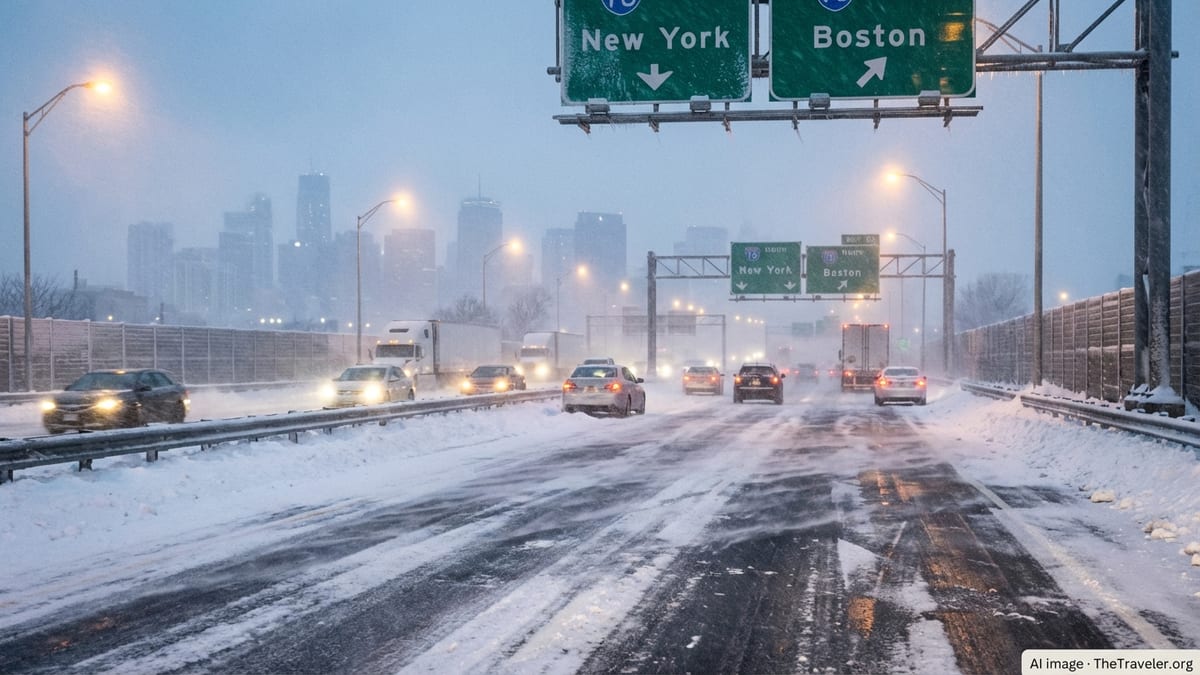
Highways Turn Treacherous as States Impose Travel Bans
On the ground, the combination of rapid snowfall, fierce winds and plunging temperatures has made road travel nearly impossible in large parts of the Mid Atlantic and New England. Governors in New York, New Jersey, Connecticut and Massachusetts declared states of emergency and imposed sweeping travel restrictions, including outright bans on non essential or commercial traffic on key highways.
Sections of Interstate 95, one of the busiest travel arteries in the United States, saw near total shutdowns as jackknifed tractor trailers, spinouts and stalled vehicles clogged lanes faster than crews could clear them. In New York City, a travel ban for non essential vehicles took effect Sunday night, leaving normally clogged bridges and tunnels eerily empty aside from emergency responders and snowplows.
New Jersey and Connecticut restricted or banned commercial vehicles on many interstates, citing the extreme risk posed by high profile trucks in 60 to 70 mile per hour wind gusts and whiteout conditions. Massachusetts limited truck travel and suspended some ferry operations, while coastal routes in Rhode Island and New Hampshire battled both drifting snow and coastal flooding from the angry Atlantic.
Officials described the situation as a “frozen traffic lockdown,” with state police repeatedly pleading with drivers to stay off the roads. In many communities, first responders reported difficulty reaching stranded motorists and medical emergencies, as secondary and rural roads drifted shut and snowplows struggled to keep up with snowfall rates that outpaced even the most robust snow removal fleets.
Urban Transit Networks Struggle Under the Weight of the Storm
The storm’s impact is being felt acutely in densely populated cities that rely on commuter rail, subways and buses to move millions of people each day. Transit agencies from Washington, D.C., to Boston reduced or suspended service as snow piled up on tracks, ice encased overhead lines and visibility plummeted for operators.
New York’s Metropolitan Transportation Authority curtailed multiple subway and commuter rail lines, particularly in exposed sections across bridges, open cuts and coastal stretches vulnerable to drifting snow. Long Island Rail Road suspended service entirely overnight, while Metro North trimmed schedules and warned of frequent delays and possible last minute cancellations.
New Jersey Transit halted all bus, rail and light rail services on Sunday evening as conditions worsened, advising riders to plan for no service through much of Monday. In Boston, the Massachusetts Bay Transportation Authority reduced subway and commuter rail frequencies and deployed crews around the clock to clear platforms, switches and station entrances buried under wind driven drifts.
For commuters who normally leave their cars at home, the simultaneous collapse of roads and public transport left few options. Many offices across the corridor shifted abruptly to remote work, while hospitals, transit agencies and utilities rushed to house essential staff on site or in nearby hotels so they could remain on duty through the height of the storm.
Power Outages, Coastal Flooding and Stranded Travelers
Beyond the immediate travel paralysis, the bomb cyclone has unleashed a cascade of secondary impacts that are compounding the crisis. Heavy, wet snow and severe winds have toppled trees and power lines from Pennsylvania to coastal Maine, cutting electricity to more than 150,000 customers and counting as crews struggle to access damaged lines in the teeth of the storm.
Along the coast, the deepening cyclone has pushed water toward shore, contributing to moderate to locally major coastal flooding during high tide cycles. Communities along Long Island’s South Shore, coastal New Jersey, Cape Cod and parts of coastal Maine reported overwash on low lying roads, minor damage to some waterfront properties and additional difficulties for plow crews operating near the water’s edge.
Inside the storm zone, countless motorists who ignored warnings or were caught by rapidly deteriorating conditions found themselves stranded in growing drifts. Social media showed images of vehicles abandoned along shoulders and exit ramps, partially buried in snow as visibility vanished. Emergency management agencies urged people who became stuck to stay with their vehicles, conserve fuel and call for help only when safely able to do so.
At rail stations and airports, travelers whose trips were canceled at the last minute scrambled to rebook and find shelter. Some spent the night on terminal floors or in waiting rooms as hotel inventory near major hubs quickly ran out, while others opted to pivot to long distance buses or rental cars, only to find those options equally constrained by the storm.
Travel Industry and Local Economies Brace for a Costly Hit
The timing and scale of the Blizzard of 2026 are shaping up to deliver a significant blow to the travel industry and local economies that depend heavily on winter and city tourism. The storm struck during a peak long weekend for city breaks and ski trips, with hotels, restaurants and attractions in New York, Boston and New England ski country preparing for strong occupancy before forecasts turned dire.
With thousands of flights canceled and road access limited, hotel managers pivoted from welcoming leisure travelers to accommodating stranded passengers, airline crews and essential workers. Some properties reported near complete turnover in reservations, with incoming tourists scrapping plans while emergency bookings surged from people simply needing a safe place to wait out the storm.
Tour operators and attractions from Broadway theaters to museum districts faced abrupt closures, issuing mass refunds or vouchers as visitors could not reach the city centers. In ski regions across Vermont, New Hampshire and Maine, resorts reported mixed fortunes: while the blizzard promised spectacular snow conditions later in the week, the immediate effect was closed access roads, suspended lift operations and cancellations from guests unwilling or unable to travel.
Economists note that while some lost economic activity may shift later into the winter, many businesses, particularly small restaurants, independent hotels and tour operators, will not be able to recoup revenue from what was expected to be a strong late February weekend. Insurance claims from property damage, lost inventory and business interruption are expected to mount once the storm clears and full assessments can begin.
How Travelers Are Adapting and What Comes Next
For travelers caught in the bomb cyclone’s path, flexibility has become the most valuable currency. Airlines are recommending that anyone with non essential travel to or through the Northeast over the next several days postpone trips entirely, as schedules will take time to normalize even after the snow stops. Many carriers are warning that aircraft and crew displacement, combined with ongoing deicing needs and runway clearing, will lead to residual delays and cancellations well into the week.
Road agencies stress that the end of falling snow does not immediately translate to safe driving conditions. With deep drifts, narrow lanes, lingering ice and poor sight lines at intersections, authorities plan to lift travel bans gradually, starting with critical freight routes and emergency access corridors. Secondary and rural roads, particularly in hilly or coastal areas, may remain treacherous for days.
Travel advisors suggest that those who must move through the region build in extra days, monitor airline apps and airport status boards frequently, and remain ready to change routes or modes of transport at short notice. Rail operators are expected to restore limited service sooner than many highways can fully reopen, making intercity trains a key option once tracks and power lines are cleared.
Looking ahead, forecasters will be watching for any follow up systems in the active 2025 to 2026 winter pattern. The bomb cyclone arrives on the heels of multiple significant winter storms that have already strained snow removal budgets and emergency response resources across much of the United States, heightening concern that the season’s worst travel disruptions may not yet be over.
Safety Tips for Those Still on the Move
Authorities emphasize that the safest choice during the height of the Blizzard of 2026 is to avoid travel altogether. For those who have no choice but to be on the road, emergency managers stress the importance of traveling with a fully charged phone and backup power, extra warm clothing and blankets, food and water for at least 24 hours, and basic roadside tools like a shovel and traction material.
Drivers are urged to keep fuel tanks as close to full as possible in case they become stranded in long backups, and to periodically clear snow from tailpipes to prevent carbon monoxide buildup if idling. If conditions worsen to the point that visibility is lost, safety officials say it is usually safer to pull off the roadway, remain with the vehicle and wait for assistance rather than attempting to continue driving blind.
Air and rail passengers should assume that schedules can change rapidly as airlines and transit agencies respond to evolving conditions. Experts recommend reconfirming reservations frequently, signing up for text alerts, and having a backup plan in mind, whether that is an alternate airport, a later departure date or a completely different route.
Above all, emergency officials and meteorologists stress that even seasoned winter travelers should not underestimate this bomb cyclone. With its combination of heavy snow, powerful winds and dangerous cold, the Blizzard of 2026 is reshaping travel plans across a broad slice of North America and offering a stark reminder of how quickly winter weather can bring a modern, mobile society to a grinding halt.