
Cochem is one of those rare river towns where everything visitors come to see fits into a compact, walkable map. The Old Town, the hilltop castle, terraced vineyards, and the Moselle riverfront all sit within a tight curve of the river, with lanes and paths that knit them together.
Seeing attractions on a map makes the things to do in Cochem easier to plan and helps you choose where to wander, when to climb, and how to link classic viewpoints into an easy day or two of exploring.
Understanding the Layout of Cochem
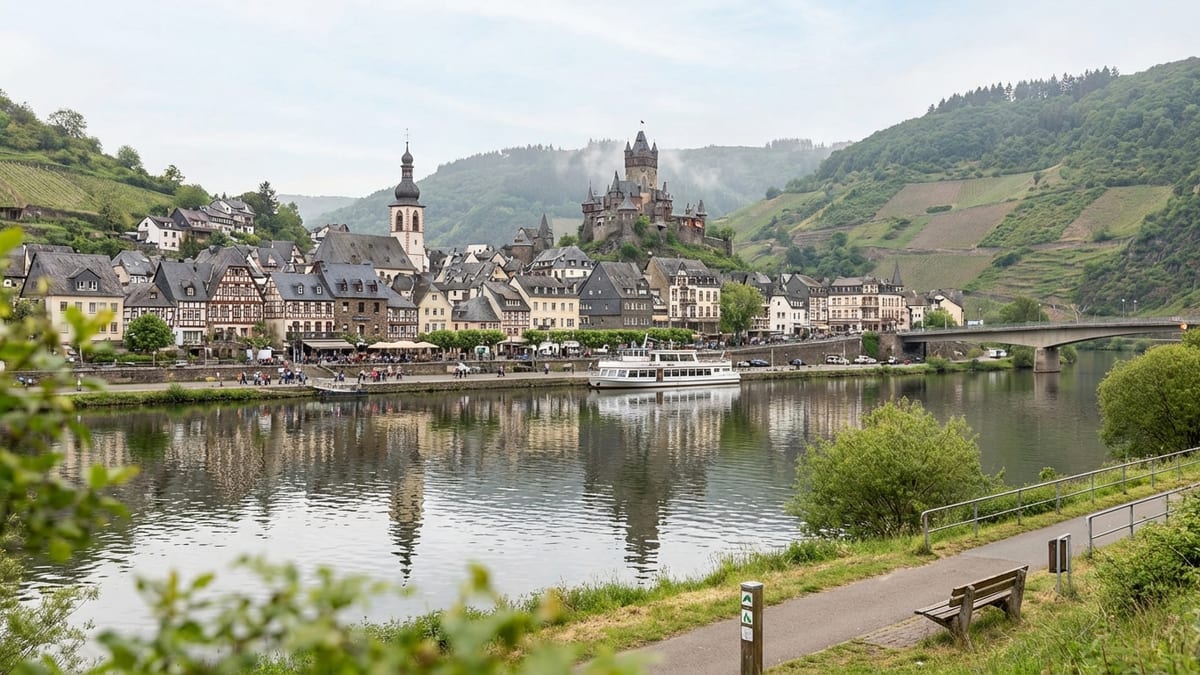
Cochem lies in a pronounced bend of the Moselle River, with the Old Town pressed against the left bank beneath Reichsburg Cochem, the restored medieval castle that dominates every skyline photo of the town. The main built-up area fans out from the riverfront into a shallow valley, hemmed in by steep vineyard slopes that rise quickly toward forested plateaus.
Across the water, the quieter district of Cond stretches along the opposite bank, connected to the Old Town by road bridges and regular river traffic. This helps you visualize the differences when comparing Cochem vs Bernkastel-Kues.
The practical center of gravity for visitors is the riverside promenade, known locally as the Moselpromenade, which runs along the left bank. From here, short streets lead into the Old Town’s medieval core and up toward the castle access road. The rail station sits slightly upriver and inland, while the chairlift to the Pinnerkreuz viewpoint climbs from the slopes behind the town. Because distances are small, most key sights fall within a 10 to 20 minute walk of one another, though the steep grades can make them feel longer.
On a mental map, imagine the Old Town as a compact rectangle, framed by the Moselle on one side and a wall of vineyards on the other. The Marktplatz and Rathaus sit roughly at its heart, with the castle above and the river boats below. The chairlift rises from the northern flank of town to a high overlook at Pinnerkreuz, where you can see Old Town, castle and vineyards spread out like a relief map. For many travelers, the most rewarding way to experience Cochem is to move between river level and these higher vantage points, using lanes, steps and walking paths that have served locals for centuries.
Old Town: Lanes, Landmarks, and Practical Orientation
Cochem’s Old Town clusters just behind the riverfront, bounded by remnants of medieval walls and gates. The main entry point for most visitors is from the Moselpromenade up into the Marktplatz, a compact square framed by half-timbered houses and the historic town hall. From the square, short spurs of cobbled lanes like Schloßstraße and Bernstraße climb toward the castle approach, while others duck down to the waterfront or snake toward old gates such as the Enderttor.
For navigation, it is helpful to think of the Marktplatz as your central reference point. Walk a few minutes downhill and you reach the river landing stages and promenade. Head uphill and you are en route to the castle. Wander out along the side streets and you soon encounter quieter pockets of Old Town, small chapels, and the occasional view slit where the houses open just enough to reveal the river. Because the street pattern predates cars, most of these lanes are narrow and either pedestrian or traffic calmed, which makes getting around on foot easy once you accept that the shortest line between two points might involve a stairway.
Useful wayfinding clues are built into the streets themselves. As you move uphill from the Marktplatz along Schloßstraße, you are essentially tracing one of the historic paths between town and fortress, and waymarked hiking routes now overlay this line. Following Bernstraße toward the market and then curving back toward the castle allows you to loop through some of the prettiest residential alleys while still remaining firmly within Old Town. Even if you step off your intended route, the steep valley sides and the constant presence of the castle turrets above ensure you never stay disoriented for long.
The Castle: Reichsburg Cochem in Its Hilltop Setting
Reichsburg Cochem stands on a spur directly above the town, about 100 meters higher than the river, on a knob of rock that has probably been fortified since at least the 11th century. From below, it appears almost vertically above the Old Town, but the access road loops around the hillside in a series of bends that moderate the climb. Visitors approach via a mixture of steep streets, signed walkways and, for those who prefer a more leisurely ascent, a shuttle bus that shuttles between lower town stops and the castle entrance in season.
On a practical level, two main walking lines connect Old Town and castle. The first begins not far from the Marktplatz, following Schloßstraße and then a clearly signed path that winds uphill through houses and vineyards. This is the route used by many guided walking tours, and it rewards patience with gradually widening views over the town rooftops and river. The second joins from Bernstraße and other side lanes, meeting the main access near St. Peter’s Chapel, sometimes nicknamed the plague chapel. Both involve stairs and uneven footing, so good footwear is important.
At the top, the castle complex spreads along the crest, with inner courtyards, walls and viewpoints that frame the Moselle valley from multiple angles. Guided tours are mandatory to see the interior rooms, but the outer wards and terraces offer some of the best perspectives for photos of the river bend, the Old Town directly below, and the patchwork of vineyards that coat the opposite slopes. On a clear day, you can trace the Moselle upstream toward Sehl and downstream past Cond, mapping out where you will explore once you return to river level.
Vineyards and Hillside Paths Above Town
One of Cochem’s defining visual features is the network of vineyards that climbs almost improbably steep slopes above the town and along the river. From the Old Town it can be hard to appreciate how these terraces are organized, but once you are on the hillside paths you realize they are carved into narrow bands, each served by a lattice of tracks and steps originally cut for winegrowers. Some of these paths have now been folded into signed walking routes that surround the town and offer a natural counterpoint to the built-up streets below.
A classic loop, promoted by local tourism authorities, strings together several of these paths into a circuit that begins either at the chairlift valley station or at Endertplatz in the north of town. Hikers follow a route that climbs toward the Pinnerkreuz viewpoint, then curves along the hillside and descends near the castle before dropping back through town. The result is an almost continuous balcony walk that hovers above Cochem, exposing a cross-section of the vineyards while also revealing how compact the town plan really is when viewed from above.
From a map perspective, the vineyards form the green belt that defines the boundary between town and plateau. Paths branch off toward neighboring villages and into side valleys, but even a short climb immediately delivers a feeling of escape. For orientation, look for waymark posts that indicate routes back to Cochem or the castle, and treat the castle towers and Pinnerkreuz cross as anchor points in the landscape. They are visible from most open stretches of hillside, acting as natural compass needles pointing you home.
The Riverfront: Promenades, Piers, and Cross-River Views
The Moselle riverfront is Cochem’s social living room, a wide band of promenade and open space that runs parallel to the water on the Old Town side. Here you find hotels, cafés, and wine taverns facing mooring points where excursion boats and longer cruise ships tie up. In map terms, the Moselpromenade is the baseline from which most sightseeing forays begin. Stand anywhere along it and you can quickly pick out your next destination: castle up to your left, Marktplatz just behind, bridges to either side linking to Cond and Sehl, and vineyards rising in tiers behind the opposite bank.
The main bridge near the center of town serves as a structural hinge in the layout, bridging Old Town on the left bank with the Cond district on the right. Walking across delivers one of the classic postcard views of Cochem: the castle crowning the ridge, Old Town packed against the water, and the gentle S-curve of the Moselle embracing it all. Further along the river, paths continue on both banks, though the left side is livelier with cafés and passenger boat landings, while the right offers slightly quieter walking with long views back toward the town skyline.
River cruises, whether short round-trips or longer legs along the Moselle, effectively expand your map of Cochem and its surroundings. From the water, you can see how the town occupies a bottleneck between steep slopes and how vineyards run almost uninterrupted along both banks. This aquatic perspective also clarifies where trails and service roads climb away from the river to link hamlets and wine estates. If you are planning walks or drives deeper into the valley, it is worth treating a short cruise as a moving orientation platform that ties the town’s streets and hillside routes into the wider geography.
Pinnerkreuz and the Chairlift: Mapping Cochem from Above
North of the Old Town, the Cochemer Sesselbahn chairlift rises from near Endertstraße to the Pinnerkreuz viewpoint, a rocky promontory topped by a cross that is illuminated at night and easily visible from the riverfront. The top station sits roughly 255 meters above sea level, significantly higher than the river and town. On a map, this puts Pinnerkreuz slightly behind and above Cochem, creating a natural observation deck from which you can understand how the town, castle, river and vineyards interlock in three dimensions.
The chairlift’s valley station is a 10 to 15 minute walk from the Marktplatz, following streets that lead north through town toward the base of the slopes. Once aboard, the ascent takes only a few minutes, passing over gardens, woods and vineyard fringes. At the top, a signed path leads to the actual Pinnerkreuz viewpoint, which looks almost straight down onto the Old Town and across to the castle on its spur. This is the place where the map in your guidebook suddenly matches what you see beneath your feet: the onion-dome church, the bridges, the castle’s curtain walls and even the precise contours of the river bend.
For walkers, the chairlift is only one way to reach the viewpoint. Footpaths climb from near the train station and from the upper edges of town, winding under or close to the lift cables before reaching the ridge and looping around to Pinnerkreuz. Many visitors choose to ride up and walk down, using waymarked routes that return via forest tracks, vineyard lanes and residential streets. However you reach it, plotting Cochem from this height is an essential part of understanding how the Old Town, castle, vineyards and riverfront compress into such a photogenic whole.
Practically Navigating Cochem: Arrivals, Distances, and Timing
From a traveler’s point of view, one of Cochem’s great strengths is its manageable scale. The rail station, tucked a short distance inland along the valley, is roughly a 10 to 15 minute walk from the Old Town riverfront. Most visitors arriving by train or regional bus simply follow the signed streets downhill toward the Moselle until they meet the promenade, then orient themselves from there. If you have luggage, some hotels along the waterfront encourage guests to stop briefly nearby to unload before continuing on to more permanent parking areas outside the medieval core, where spaces are limited and fees vary by season.
Once checked in, you can comfortably explore the main sights on foot. Allow around 10 minutes to stroll from the Marktplatz to the central bridge, another 10 to 20 minutes of uphill walking to reach the castle entrance, and a similar amount of time to reach the chairlift valley station on the northern edge of town. The vineyards begin almost at the back doors of some Old Town houses, but you will want to budget 20 to 30 minutes for a modest climb to reach more open hillside paths that give you uninterrupted views.
In terms of timing, plan half a day to link Old Town, castle and riverfront at a relaxed pace, and a full day if you also want to ride the chairlift, visit Pinnerkreuz and walk one or two hillside loops. Another day can easily be filled with vineyard visits, longer river cruises or day trips to neighboring villages. Because Cochem is a functioning small town rather than a pure museum piece, you will find grocery stores, bakeries, and services scattered just beyond the obvious tourist corridors, especially along streets leading toward the station and uphill residential areas.
FAQ
Q1: How long does it take to walk from Cochem’s riverfront to Reichsburg Cochem?
Most visitors should plan on 20 to 30 minutes of steady uphill walking from the Moselpromenade or Marktplatz to the castle entrance, depending on pace and route. The ascent is short but fairly steep, with some sections of steps and cobbled paths.
Q2: Is the Old Town of Cochem mostly pedestrianized?
Yes, the core around the Marktplatz and many of the narrow lanes leading toward the castle are pedestrian or carry only limited local traffic, which makes walking the most practical way to navigate the historic area.
Q3: Can I reach Pinnerkreuz viewpoint without using the chairlift?
Yes, several signed hiking paths climb from town and the rail station area to the ridge and then on to Pinnerkreuz. The ascent usually takes between 30 and 60 minutes on foot, depending on the route and your fitness level.
Q4: How far is the train station from the riverfront promenade?
The Cochem rail station sits roughly 10 to 15 minutes on foot from the Moselpromenade. The route is slightly downhill heading toward the river and is straightforward to follow using local signage.
Q5: Are the vineyards around Cochem accessible for casual walkers?
Yes, many vineyard paths around Cochem are open to walkers and form part of well-marked hiking routes. Expect steep gradients and uneven surfaces, but you do not need special equipment beyond sturdy shoes and weather-appropriate clothing.
Q6: Is it better to stay on the Old Town side or across the river in Cond?
Staying in the Old Town places you closer to the Marktplatz, castle routes and the busiest section of the riverfront. Cond, on the opposite bank, is quieter and offers excellent views back toward the castle and historic core, with easy walking access across the bridge.
Q7: Do I need a car to explore Cochem and its main sights?
No, for Cochem itself a car is not necessary. The Old Town, castle, chairlift, riverfront and nearby vineyard paths are all walkable from central accommodations. A car becomes more useful only if you plan to range widely along the Moselle or into the Eifel hills.
Q8: When is the best time of year to enjoy Cochem’s vineyards and viewpoints?
Late spring through early autumn is ideal, when vineyard foliage is lush and trails are generally dry. Autumn grape harvest season adds color and activity, while shoulder seasons are quieter but can bring more variable weather and shorter opening hours for some attractions.
Q9: Are there accessible viewpoints for those who cannot manage steep climbs?
The riverfront promenade offers level views of the castle and vineyards, and some river cruises provide elevated perspectives without the need for hiking. Access at the castle and upper viewpoints involves slopes and steps, so travelers with limited mobility should check the latest local information and consider transport options that minimize walking.
Q10: How much time should I plan for a first visit that covers Old Town, castle, vineyards and riverfront?
Two full days is a comfortable minimum to experience Cochem’s core areas without rushing. One day allows you to explore Old Town, the castle and riverfront, while a second day can be devoted to vineyard walks, the chairlift to Pinnerkreuz, or a scenic cruise along the Moselle.