
By the time the pavement narrowed and the trees began to knit a tunnel overhead, the Keweenaw Peninsula had already started to feel like a place the rest of the Great Lakes had somehow forgotten. Out on this long finger of rock reaching into Lake Superior, highway signs thin out, cell service flickers, and the road runs so close to the water that wind-driven spray can speckle your windshield. Driving here is less about ticking off attractions and more about surrendering to a landscape that still seems intent on doing things its own way.
Finding the Edge of the Map
The Keweenaw Peninsula begins quietly. Leaving the relative bustle of Houghton and Hancock, you cross the lift bridge and watch the last chain stores disappear in the rearview mirror. US 41 slips into the woods, climbing past old mine structures and Italianate brick buildings that speak to the region’s copper boom. Before long, the highway narrows and curves, framed by birch, maple, and spruce that arch overhead like a living tunnel. It feels less like heading toward a tourist destination and more like driving into a story that most travelers never hear.
Unlike more heavily promoted corners of the Great Lakes, there is little sense of spectacle here. Gas stations and motels give way to weathered homes, shuttered general stores, and clusters of mailboxes at the ends of long gravel drives. The road surface shifts from fresh asphalt to patched and frost-heaved sections that demand your attention, especially after the long Upper Peninsula winter. Distances are short on the map, but the driving is slow, the kind that forces you to settle into the rhythm of the peninsula.
What emerges, mile by mile, is a feeling that the Keweenaw exists slightly outside the usual currents of seasonal tourism. This is a place shaped by snow measured in feet, by a mining economy that rose and fell generations ago, and by a lake so vast it can generate its own weather. As you continue north, the peninsula narrows and the sense of remoteness deepens, until it seems entirely plausible that you have driven past the edge of the map.
Tracing Lake Superior from Eagle River to Copper Harbor
One of the most striking sections of the drive begins where the twin routes of US 41 and M 26 split near Phoenix. Follow M 26 to stay close to the shoreline, and the road quickly reveals why local tourism offices highlight it as a signature coastal drive. To the left, houses and forests rise toward old copper cliffs; to the right, breaks in the trees open suddenly to Lake Superior, which can look steel gray and combative one moment and glassy blue the next.
The villages along this stretch feel like outposts that the lake has allowed to remain. Eagle River, with its compact cluster of buildings, a river dropping toward the lake, and a shoreline of wave-rounded stones, seems built on a comfortable scale, as if sized to withstand long winters and late springs. A few miles east, Eagle Harbor offers a sheltered inlet, a lighthouse standing watch on the point, and a small grid of streets that are busiest in summer yet rarely feel crowded. Many businesses still operate on seasonal schedules, so travelers quickly learn to check opening months and hours in advance or be prepared to improvise.
Between these communities, M 26 threads along the base of cliffs and low bluffs. In autumn, the slopes flame with color, earning regular mention in fall color guides across the Midwest. In spring, snowbanks can linger at the forest edge long after the shoulders of the road are bare. Pullouts, informal and official, allow for quick stops to watch shifting weather roll across Superior, to scan for passing freighters on the horizon, or to simply listen to the endless comb of waves on the cobble beaches below.
Even in peak travel months, traffic here tends to move at the pace of the slowest driver, and few people seem inclined to hurry. You share the road with pickup trucks, campers, and the occasional touring cyclist inching along the shoulder. It is not unusual to drive several miles without seeing another vehicle, particularly early or late in the day, reinforcing the sense that the Keweenaw is a place you enter on the lake’s terms, not your own timetable.
Brockway Mountain Drive and the High Spine of the Keweenaw
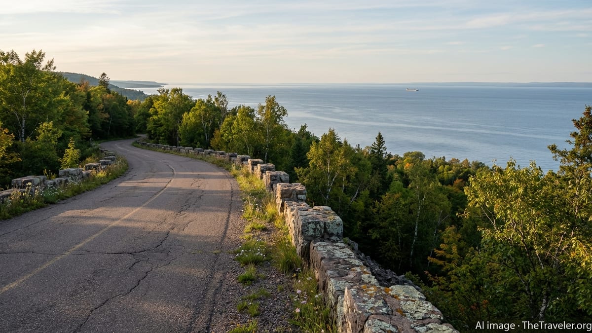
Near Copper Harbor, the road rises off the shoreline and climbs toward one of the peninsula’s defining features: Brockway Mountain Drive. Often described by local tourism boards as one of Michigan’s most scenic routes, this narrow, nearly nine mile road branches off M 26 and winds up to roughly 1,320 feet above sea level, about 720 feet above the surface of Lake Superior. Constructed in the 1930s as a Depression-era project, it remains a seasonal road, closed to vehicles through the snowy months and typically opening in mid to late spring once snow and ice have receded.
From the moment you turn uphill, the driving experience shifts. The pavement narrows and begins a series of steep climbs and rolling bends. There are no centerlines, no shoulders to speak of, and the asphalt shows the scouring effect of harsh winters and freeze-thaw cycles. Stone guardrails, built from local rock, line the outer edges in places, but much of the time the protection is simply the driver’s own caution. Visitors are encouraged to use low gears, drive slowly, and be ready to yield to oncoming traffic at tight spots.
What keeps travelers returning year after year, despite the challenging conditions, is the view. Several overlooks punctuate the route, culminating in a summit area with panoramic vistas. On clear days, Lake Superior stretches to the northern horizon, and the green spine of the Keweenaw rolls away to the south, broken by small inland lakes and patches of wetland. Far off to the north, attentive visitors sometimes report seeing the distant outline of Isle Royale, hovering on the edge of visibility. The air at the top is often cool and windy even in midsummer, and the light can shift from bright sun to low clouds within minutes.
In spring, birders gather along the ridge to watch migrating raptors and other species ride the updrafts that form along the cliff. Summer brings families with picnic lunches and mountain bikers accessing trailheads that crisscross the high ground. Autumn, however, may be the most celebrated season, when guidebooks and travel articles alike point to Brockway Mountain as one of the Midwest’s most impressive places to see fall foliage. From this vantage point, the peninsula becomes a quilt of color, stitched together by the dark ribbon of M 26 and the blue expanse of Superior.
Copper Harbor: Where the Road Runs Out
Descending from Brockway Mountain, the road spills into Copper Harbor, a compact village at the northern tip of the Keweenaw. Here, US 41 effectively ends, concluding its long run from Miami in a quiet tangle of local streets fringed by spruce, cedar, and the lake itself. The sense of being at the end of something is palpable. The pavement simply stops, turning into gravel lanes leading toward trailheads, shoreline access points, and a modest marina.
Copper Harbor serves as a launch point rather than a destination in the conventional sense. A small cluster of lodges, motels, cabins, and campgrounds caters to visitors from late spring through fall. Restaurants and cafes operate on limited hours and seasons, reflecting the reality of a community that empties out dramatically once snow begins to pile up. Ferry service to Isle Royale typically runs from late spring to early autumn, further reinforcing the harbor’s role as a gateway to even more remote terrain.
Despite its modest size, the village offers more than enough to fill a day or two. Paddlers ease sea kayaks into the protected waters of the harbor, while anglers work the breakwalls and nearby rivers. Mountain bikers fan out across a fast-growing network of purpose-built trails in the surrounding hills, a system that has drawn national attention within the riding community. Hikers head for old-growth white pine at Estivant Pines, or follow coastal paths that keep the lake in sight and earshot.
In the evenings, the harbor settles into a rare quiet. Without the glow of big-city lights, night comes quickly and decisively. On clear nights, the sky is dense with stars, and visitors occasionally report faint veils of northern lights along the northern horizon. The combination of darkness, silence, and the rhythmic slap of water against the docks makes Copper Harbor feel almost suspended in time, as if it has stepped to the margin of the modern Great Lakes and chosen to stay there.
Ghosts of Copper and the Human Story of the Keweenaw
Driving the Keweenaw is not only a scenic experience; it is also an immersion in layers of human history that remain visible at the roadside. The Copper Country Trail National Byway, which largely follows US 41 through the peninsula, links remnants of the region’s once-dominant copper mining industry. Headframes, shaft houses, stamp mills, and poor rock piles dot the hillsides, sometimes preserved as historic sites, sometimes left to weather back into the landscape.
Many of the towns you pass began as company communities in the late nineteenth and early twentieth centuries, when the Keweenaw was one of the world’s major sources of copper. Streets lined with ornate brick buildings and substantial churches suggest prosperity that far outstripped today’s populations. The collapse of large-scale mining left behind both economic challenges and a distinctive built environment that gives modern Keweenaw communities their particular character. For travelers, the result is a drive through places where empty storefronts can exist alongside lovingly restored historic structures and small businesses powered by outdoor tourism.
Along the route, museums and heritage sites interpret this past. Some travelers walk through preserved mine buildings, descend into demonstration shafts, or explore historic neighborhoods where immigrant communities once clustered by language and nationality. Others absorb the story more casually, reading interpretive signs at roadside pullouts or simply noting how many place names and landmarks carry the legacy of mining companies and early settlers.
Over time, the Keweenaw’s economic focus has shifted toward education, health care, and outdoor recreation, but the mining era still shapes how people see themselves and the land. Old rail grades have become trails. Mine pits hold water that reflects autumn hillsides. Abandoned structures form the backdrop for new festivals and events. For the traveler, this juxtaposition of industrial relics and natural recovery deepens the sense that the Keweenaw is both a place of endings and of quiet reinvention at the far edge of the Great Lakes.
Weather, Seasons, and the Realities of Driving Here
To truly appreciate the Keweenaw as a driver, it helps to understand how profoundly the seasons control life on the peninsula. This is a region known for heavy lake-effect snow, where winter storms can close roads, pile drifts higher than pickup trucks, and extend deep into spring. Seasonal roads such as Brockway Mountain Drive remain gated until snow melts and crews can safely clear the route, which may not occur until May depending on conditions. Even main highways can be subject to temporary closures or reduced visibility during intense storms.
Summer brings more stable conditions, but the lake still exerts a strong influence. Cool breezes keep shoreline communities comfortable, even during regional heat waves. Fog can roll in quickly, lowering visibility and dampening the forest in minutes. Sudden, localized downpours are not uncommon, especially on warm afternoons. For drivers, this means staying flexible, allowing extra time between destinations, and recognizing that conditions can change from one side of the peninsula to the other.
Autumn may be the most popular season for road trippers, thanks to widespread coverage of Upper Peninsula fall colors. By late September and early October, hardwoods along US 41, M 26, and Brockway Mountain typically turn shades of red, orange, and gold. Travel media outlets frequently highlight this as one of the Midwest’s premier foliage drives, and lodging can book up well in advance. Drivers should be prepared for slower traffic, frequent camera stops, and the occasional wildlife crossing as deer move actively through the forest.
Spring, by contrast, is quieter and can feel almost private. Snowbanks retreat slowly, revealing rushing creeks and waterfalls swollen with meltwater. Some attractions and businesses open gradually through April and May, so advance planning is useful. Potholes and frost heaves are most pronounced at this time of year, a reminder of the strain that winter places on the road network. Anyone planning an early-season visit should be ready for wet shoulders, variable pavement, and the possibility that a much-anticipated scenic side road may not yet be passable.
Practical Tips for a Keweenaw Peninsula Road Trip
A successful Keweenaw road trip starts with accepting that this is a landscape best approached at a modest pace. Distances may look short on a map, but winding roads, narrow lanes, and frequent scenic stops stretch travel times. Visitors are wise to build in long margins between planned activities and to view the driving itself as a central part of the experience rather than a chore to be rushed through. Even at the height of summer, it is possible to find yourself alone on a stretch of shoreline or at a pullout with only the sound of waves and wind for company.
Fuel and services are less frequent here than in more populated regions, so topping off the tank in larger communities such as Houghton, Hancock, or Calumet is prudent. Cell coverage can be spotty, particularly along certain shorelines and in low-lying forested areas, so offline maps and printed directions remain useful tools. Weather forecasts deserve close attention, and checking on seasonal openings for roads, campgrounds, and attractions can help avoid disappointment. Local visitor centers in Houghton, Calumet, and Copper Harbor offer up-to-date information on road conditions, trail access, and any temporary closures.
Vehicle choice also shapes the experience. Passenger cars manage most main routes without difficulty in summer and early autumn, but low-clearance vehicles may encounter challenges on some unpaved side roads and trailhead access tracks. Brockway Mountain Drive, with its steep grades and rough patches, rewards cautious driving and is not ideal for large trailers or drivers uncomfortable with heights. Many road trippers divide their exploration into loops, combining a shoreline segment on M 26 with a return on US 41, or linking waterfall visits, historic sites, and hikes into multi-day itineraries that never stray far from the main highways.
Ultimately, the most valuable preparation may be mental. The Keweenaw is not a region built for instant gratification. Restaurant options may be limited, store hours can be abbreviated, and weather rarely behaves like a predictable backdrop. Those who arrive ready to adapt, to linger when a view demands it or to change plans when rain sweeps in off the lake, tend to come away with the strongest memories. It is this slow, responsive style of travel that reveals why driving the peninsula feels less like a conventional road trip and more like discovering a pocket of the Great Lakes that time has largely overlooked.
The Takeaway
After a few days of tracing its roads, it becomes clear that the Keweenaw Peninsula does not compete with more famous Great Lakes destinations on their terms. There are no long strings of beachfront condos here, no skyline of glass towers reflecting the water. Instead, there are cliff-hugging highways, village streets anchored by brick buildings whose best years might be either ahead or behind them, and long empty stretches where the only constant is the presence of Lake Superior. The peninsula asks drivers to notice subtler things: the angle of a rusted headframe on a hill, the way evening light reaches under low clouds to catch the tops of waves, the quiet of a harbor after the last boat has tied up for the night.
In that sense, driving the Keweenaw can feel like discovering a forgotten corner of the Great Lakes not because no one comes here, but because so much of what defines the region has been allowed to endure. The roads still follow the contours of bedrock and forest rather than development pressures. Seasonal closures remind visitors that weather, not convenience, sets the schedule. Communities that might elsewhere have been smoothed into generic resorts retain a lived-in, year-round authenticity. For travelers willing to embrace distance and unpredictability, the reward is a rare kind of intimacy with both landscape and history.
When you finally turn south and watch the peninsula widen behind you in the rearview mirror, the Keweenaw lingers in small details: the way your clothes still smell faintly of woodsmoke and lake air, the memory of cresting Brockway Mountain into a sky that seemed to open in all directions, the knowledge that out there, beyond the easy reach of most itineraries, a narrow peninsula continues pointing into Superior, holding its quiet place at the edge of the map.
FAQ
Q1. When is the best time of year to drive the Keweenaw Peninsula?
The most popular months are late June through early October, when roads are clear, most services are open, and weather is generally mild.
Q2. Is Brockway Mountain Drive open year-round?
No. Brockway Mountain Drive is a seasonal road that typically opens in mid to late spring and closes again before or during winter due to snow and ice.
Q3. Do I need a four wheel drive vehicle to explore the peninsula?
For main routes like US 41 and M 26 in summer and early fall, a standard passenger car is usually sufficient, though some unpaved side roads may require more clearance.
Q4. How much time should I plan for a Keweenaw Peninsula road trip?
A full day allows for a basic loop to Copper Harbor and back, but two to three days provide a more relaxed pace with time for hikes and side trips.
Q5. Are gas stations and services widely available?
Fuel is available in key communities such as Houghton, Hancock, Calumet, and near Copper Harbor, but stations are spaced out, so topping off regularly is wise.
Q6. What should I know about winter driving in the Keweenaw?
Winters are snowy and can be severe. Main highways are plowed, but conditions may be challenging and some secondary or scenic roads may be closed entirely.
Q7. Is cell phone service reliable throughout the peninsula?
Coverage is generally good near larger towns but can be weak or intermittent along remote shorelines and forested stretches, so offline maps are helpful.
Q8. Can I visit historic copper mining sites by car?
Yes. Several former mines and related sites along the Copper Country Trail National Byway are reachable by car and offer tours or interpretive exhibits in season.
Q9. Are there good opportunities for hiking and biking just off the main roads?
Yes. Trail networks near Copper Harbor, Brockway Mountain, and other areas connect directly or via short access roads to hiking and mountain biking routes.
Q10. Do I need to reserve lodging in advance?
During peak summer weekends and the fall color season, it is strongly recommended to book lodging ahead, as options are limited and can fill quickly.