
More news on this day
Drivers and public transport users in Glasgow are being urged to brace for fresh disruption as a series of major road and streetscape projects prepare to introduce extensive temporary traffic lights on key approaches to and through the city centre.
Get the latest news straight to your inbox!
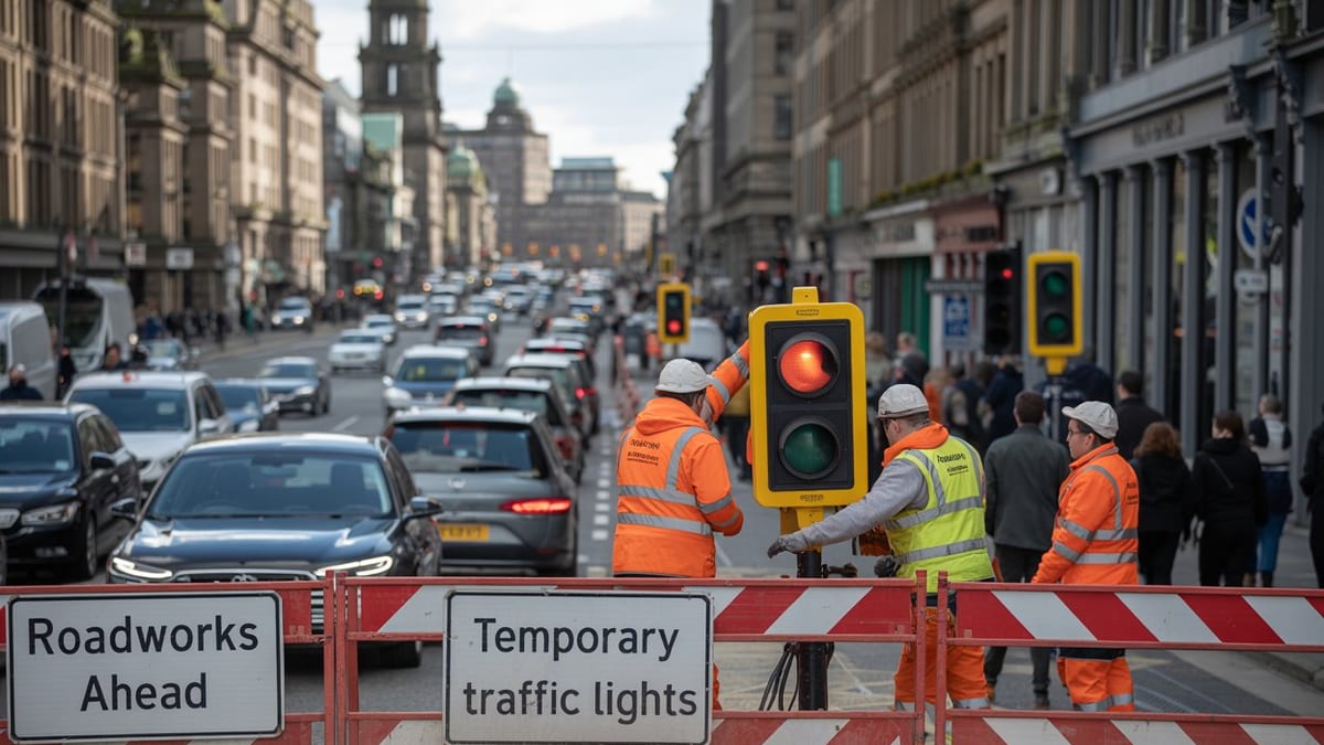
Image by Latest International / Global Travel News, Breaking World Travel News
Where the biggest traffic pinch points are expected
Publicly available information on current and upcoming schemes indicates that some of the heaviest disruption is likely to focus on the M8 corridor around Charing Cross, the Argyle Street and city centre “Avenues” projects, and busy approaches serving the wider Glasgow City Region. Together, these works are expected to generate a rolling programme of temporary traffic light controls on already congested junctions.
On the M8 in central Glasgow, long running repairs at the Woodside Viaduct near Charing Cross are scheduled to continue into 2027, with traffic management remaining in place for at least another year. Recent updates on the scheme indicate that the eastbound carriageway is not expected to return to more normal running until autumn 2026, keeping pressure on diversion routes and junctions controlled by temporary signals in the surrounding streets.
Inside the city centre grid, the Argyle Street East Avenue project is now moving into construction after a contract award reported in March 2026. The scheme covers Argyle Street between the Union Street and Jamaica Street junction and Glasgow Cross, a corridor that already sees heavy bus and general traffic. Observers note that buses using the area already move through a series of closely spaced junctions and signalised crossings, and the introduction of temporary traffic lights during construction is expected to slow movements further.
Reports shared by local road users also point to intermittent temporary lights on key distributor streets such as St Vincent Street and routes serving junctions off the M8. Even short sections of works at these locations have recently been described as creating long queues, suggesting that relatively modest additional restrictions could quickly add to journey times at peak periods.
How long Glasgow drivers may face temporary signals
The timescales attached to the current wave of projects suggest that temporary traffic management will be a fact of life for many Glasgow commuters for months and, in some cases, years. Repair work on the Woodside Viaduct has already been in place for more than four years, and the latest projected schedule points to full completion and removal of traffic management in the second half of 2027. The expectation that the eastbound carriageway will not reopen until late 2026 underlines how sustained the disruption is likely to be.
For Argyle Street East, contract information indicates a 36 month delivery period for the upgrade, which includes new road surfaces, widened footways, cycleways and public realm. While not every phase will require the same level of restriction, city centre streets are tightly constrained and temporary traffic lights are expected to appear at multiple points along the corridor as crews move block by block.
Parallel work across the wider Glasgow City Region, such as junction improvements and active travel links highlighted in recent regional performance reports, also tends to rely on temporary traffic signals to manage lane closures and protect work areas. This means drivers may experience a patchwork of stop-go controls on feeder routes heading into the city, particularly where older junction layouts are being redesigned for pedestrians and cyclists.
Although some schemes avoid the busiest holiday travel periods or school term peaks, the cumulative impact of overlapping programmes means that there is unlikely to be a clear, disruption free window for motorists in 2026. Instead, traffic patterns are expected to shift as particular sets of temporary lights are removed in one area while new ones appear elsewhere.
Key projects behind the latest works
Several large scale infrastructure and streetscape initiatives are converging to create the latest wave of temporary lights around Glasgow. The Woodside Viaduct repairs on the M8 are being carried out to address structural defects on one of the most heavily used sections of motorway through the city. The works involve complex strengthening measures that require lane closures and long stretches of reduced capacity, with signalised approaches used to meter traffic and keep flows moving where possible.
Within the city centre grid, the Avenues programme is reshaping streets to prioritise people on foot, bike and public transport. Argyle Street East is one of the flagship projects in this programme, with plans for wider pavements, new segregated cycle routes and more planting. Construction requires substantial reconfiguration of the existing carriageway, making temporary traffic lights a central tool for handling restricted lanes and alternating flows through work zones.
Further north and west, regional reports highlight additional corridor upgrades and junction schemes that support improved links between major destinations such as the University of Glasgow and the Queen Elizabeth University Hospital. While some of this work has already been completed, follow on phases and associated utility diversions still rely on temporary traffic signals at pinch points, particularly where space for contraflow arrangements is limited.
Beyond these headline projects, smaller but numerous road maintenance, resurfacing and utility works continue to appear on local roads. Recent discussions among residents and commuters reference temporary signals at Charing Cross, on approaches to motorway junctions and at busy crossroads in neighbourhoods such as Bearsden Road and St Vincent Street, reinforcing the impression of near constant low level disruption.
What drivers, cyclists and pedestrians should expect
For people travelling into or across Glasgow, the most immediate impact of the upcoming roadworks and temporary lights is likely to be longer and less predictable journey times. Even well calibrated temporary signals typically reduce throughput compared with permanent installations, especially where a single lane must handle two way traffic or where pedestrian stages take up a larger share of the cycle.
Motorists can expect to see more stop start conditions on approaches to junctions, with queues building more quickly than usual at peak periods. Accounts from drivers navigating existing temporary lights at locations such as Charing Cross suggest that backlogs can extend well beyond the immediate work zone, particularly when closely spaced junctions interact and block each other.
Bus passengers may feel the effects in the form of slower services and timetable variability on corridors like Argyle Street and Ingram Street. Reports describing current conditions note that buses already pass through multiple signalised junctions in a short distance, and additional temporary lights during construction phases are likely to add further delay. Operators may respond with revised running times or diversions if congestion proves persistent.
For cyclists and pedestrians, the picture is more mixed. In the short term, diversions around worksites and narrowed footways can be inconvenient, and temporary crossings may require longer waits. However, many of the schemes driving the current activity are designed to improve safety and comfort for non motorised users in the longer term, with wider pavements, protected cycle lanes and new public spaces forming a core part of the investment.
How to plan around the disruption
With temporary traffic lights set to feature prominently on Glasgow’s roads through 2026 and beyond, journey planning will be essential for anyone who relies on driving or surface public transport. Commuters are advised, based on published guidance from transport providers and previous roadwork programmes, to allow additional time for peak hour trips and to consider earlier or later departures where possible.
Real time mapping and traffic information services can help identify where temporary lights are currently causing delays, although some local commentary suggests that not all closures and restrictions are consistently reflected in popular navigation apps. Checking multiple sources, including official roadworks portals and operator updates, may therefore provide a more accurate picture of likely hold ups.
Where alternatives exist, switching from cross city car journeys to rail or subway services for the most congested sections could reduce exposure to road based disruption. Park and ride options, car sharing and combining modes, for example by cycling part of the way on new active travel routes, may also help some travellers maintain predictable door to door times.
Businesses that depend on reliable vehicle access, such as delivery firms and city centre retailers, may need to adjust logistics plans, including re timing deliveries outside peak hours or re routing to avoid known hotspots. With several schemes scheduled to run into late 2026 and 2027, the need to adapt is likely to be ongoing rather than temporary.