
More news on this day
Virginia has become the latest flashpoint in a sprawling winter weather onslaught stretching from the Pacific Northwest to the Mid-Atlantic, as a fresh round of heavy snow, fierce winds and avalanche risks compounds weeks of storms, snarling travel and heightening safety concerns for millions of Americans on the move.
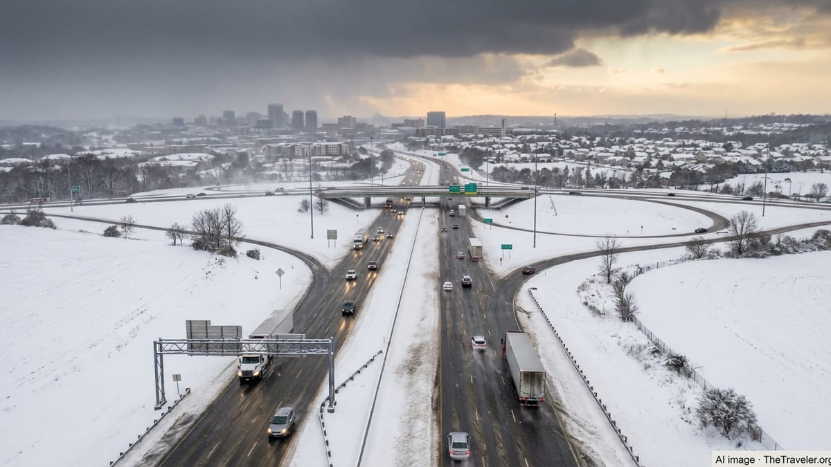
Fresh Alerts Put Virginia Back in the Winter Crosshairs
After enduring a deadly late-January winter storm and a subsequent bomb cyclone, Virginia is once again staring down disruptive winter weather, with forecasters warning that a new coastal system could intensify into a powerful nor’easter from February 22 into February 23. The storm is expected to spread snow and strong winds along the Interstate 95 corridor from Washington, D.C. through Richmond and up toward the Northeast, potentially delivering several inches of accumulation and rapidly deteriorating travel conditions.
State transportation officials and emergency managers in Virginia are urging drivers to avoid unnecessary travel during the height of the storm, citing lessons from last month’s system, which triggered more than 500 crashes on snow- and ice-covered roads and temporarily shut express lanes on critical commuter arteries. Many school districts and local governments have already begun contingency planning for possible closures and schedule changes as confidence grows in another bout of disruptive winter weather.
Major hubs including Washington Dulles International Airport and Reagan National are preparing for delays and cancellations, with airlines adjusting schedules and waiving change fees for travelers who can shift plans to less volatile windows. Rail operators and intercity bus carriers are also bracing for reduced service or weather-related suspensions if snow bands intensify along key Mid-Atlantic corridors.
For travelers, the renewed round of winter hazards in Virginia underscores how quickly conditions can shift this season. Even short drives between cities in the region may traverse vastly different weather zones, from rain-slicked roads near the coast to heavy, blowing snow only a few miles inland, complicating last-minute weekend getaways and routine business trips alike.
Washington and Oregon Confront Mountain Snow and Coastal Turbulence
Farther west, the Pacific Northwest remains locked in an unsettled pattern, with Washington state facing bouts of heavy mountain snow and periods of coastal rain and wind that are disrupting both local commutes and interstate travel. A series of Pacific systems is funneling moisture into the region, dropping snow across the Cascades and elevating avalanche dangers on popular passes just as the winter sports season reaches a peak.
On higher routes such as Snoqualmie and Stevens Pass, fresh snowfall coupled with gusty winds has periodically reduced visibility and forced transportation officials to impose traction requirements or temporary closures. Truckers and long-distance drivers moving between Washington and interior western states are being advised to carefully time crossings, as quickly changing conditions can transform wet pavement into treacherous, snow-packed surfaces in a matter of hours.
Coastal communities from the Olympic Peninsula to southwestern Washington have seen strong onshore winds and rough seas, complicating ferry operations and leading to occasional cancellations. While temperatures near sea level have remained relatively mild, the combination of rain, standing water and localized flooding around low-lying roads has still managed to slow traffic and extend journey times for residents and visitors alike.
For travelers connecting through Seattle-Tacoma International Airport, weather-related delays have been relatively modest compared to some of the nation’s hardest-hit hubs, but airlines are closely monitoring incoming systems. With winter weather targeting both East and West coasts, disruptions in one region are increasingly cascading through national networks, turning a localized storm in Washington into missed connections thousands of miles away.
Wyoming’s High Plains and Mountain Passes Face ‘Life-Threatening’ Snow
In Wyoming, forecasters have warned of what they describe as potentially life-threatening winter conditions in higher elevations, as deep snow and powerful winds combine to create whiteouts and dangerously low wind chills. A winter storm warning covers sections of the Sierra Madre and nearby ranges, where totals could reach up to three feet of snow and gusts may approach 60 miles per hour.
The National Weather Service has cautioned that outdoor recreation in exposed mountain terrain could quickly turn hazardous for anyone caught unprepared, with blowing and drifting snow obscuring trails and making navigation difficult even for experienced backcountry travelers. Avalanche risks are also rising where recent snowfall is piling onto older, unstable layers, complicating rescue efforts in remote zones.
On the state’s highways, including key trucking routes that link the Rocky Mountain West with the Midwest, plow crews are working around the clock to keep at least one lane open, but extended closures remain a possibility when visibility drops near zero or when high-profile vehicles cannot safely contend with crosswinds. Authorities have not hesitated to advise motorists to delay all nonessential travel when conditions are at their worst, emphasizing that stranded vehicles can quickly become emergency situations in subzero wind chills.
For travelers heading to popular winter destinations in Wyoming, such as ski resorts and national park gateway towns, planning has become a balancing act between chasing fresh powder and respecting the volatility of mountain weather. Flexible itineraries, robust cold-weather gear and readiness for last-minute route changes are now essential for anyone navigating Wyoming’s winter landscape.
California’s Sierra Nevada: From Deep Powder to Deadly Avalanche Risk
California’s mountains are among the most dramatically impacted by this latest multi-state winter siege. A prolonged train of Pacific storms has dumped staggering amounts of snow across the Sierra Nevada, shutting down major arteries, fueling dangerous avalanche conditions and reshaping travel plans for thousands of skiers, snowboarders and long-haul drivers.
In the northern Sierra, Interstate 80 has seen repeated closures and restrictions in recent days after blizzard conditions produced more than two feet of snow in just 24 hours over some summit stretches. Plows have struggled to keep pace with snowfall rates that have at times approached three inches an hour, while strong ridge-top winds have whipped the loose powder into near-total whiteouts.
Further south, the avalanche danger has reached critical levels in the backcountry following the deadliest slide in the region in decades, which claimed multiple lives among a group of skiers and left rescuers contending with unstable slopes and shifting weather. Avalanche centers have urged the public to treat closed terrain and high-risk areas with extreme caution, noting that rapid swings between warm and cold temperatures have created weak snowpack layers now loaded by heavy new snow.
Even outside the highest peaks, the travel picture remains difficult. Resort access roads have alternated between chain controls, rolling closures and long delays, while regional airports on the eastern side of the Sierra and nearby Nevada communities are grappling with cancellations and diversions. While many visitors still see the deep snow as a winter playground, officials are keen to remind them that the same storms fueling postcard views are also driving a complex, evolving safety challenge.
Kentucky and the Central Appalachians Brace for Renewed Snow and Ice
In Kentucky and neighboring states along the central Appalachian corridor, winter weather is again in the forecast after an already bruising season of snow, flooding and ice. Fresh systems advancing from the west are expected to deliver additional rounds of accumulating snow across eastern Kentucky, with localized totals of several inches possible on higher ridges and along key travel routes.
Forecasters warn that the new snowfall will fall on top of previously compacted layers and intermittently frozen surfaces, heightening the risk of slick roads even in areas that see relatively modest totals. Mountain passes and rural roads, where plow coverage can be more limited, are likely to present the most serious challenges for drivers, particularly during overnight hours when temperatures drop and black ice forms.
Kentucky’s recent history with extreme weather, including deadly flooding and widespread winter power outages over the past year, has sharpened public awareness of how quickly seasonal storms can escalate into crises. Utility companies have staged extra crews and equipment closer to vulnerable communities, while emergency managers stress the importance of having backup heat sources, charged mobile devices and a basic supply kit for anyone who must travel.
For travelers driving between the Midwest and the Southeast, routes that cross eastern Kentucky and adjacent sections of West Virginia, Tennessee and Virginia may pose intermittent hazards as bands of snow and mixed precipitation march eastward. Real-time road conditions, rather than statewide averages, are becoming the decisive factor in whether to press on or pause a journey as storms pulse through the region.
Nationwide Travel Chaos as Storms Collide With Peak Winter Mobility
The latest wave of winter weather across Virginia, Washington, Wyoming, California, Kentucky and additional states is landing at a time of heavy seasonal travel, magnifying its impact on roads, rails and runways. In the air, clusters of cancellations at a few key hubs are rippling across networked schedules, turning what might be a localized weather event into a national web of missed connections and rebookings.
Airlines have responded by activating flexible rebooking policies for affected cities, encouraging passengers to move their trips away from the worst-forecast windows. However, as storms hit both coasts and thread across the country’s central spine, truly unaffected alternatives are becoming scarcer. Travelers are being advised to build in longer layovers, monitor status updates closely and keep essentials such as medications, chargers and a change of clothes in carry-on bags in case overnight disruptions occur.
On the ground, intercity bus and rail operators from the Pacific Northwest to the Mid-Atlantic are adjusting timetables, shortening routes or preemptively canceling selected services where snow, ice and high winds are likely to make operations unsafe. For many rural communities, where such services provide vital links to medical care and essential shopping, even short suspensions can carry outsized consequences, particularly if local roads also become impassable.
Within states, tourism boards and park managers are wrestling with complex decisions about access to natural attractions. Some mountain parks and high-elevation scenic byways have been temporarily closed to prevent visitors from becoming stranded, while lower-elevation sites remain open but under advisories for quickly changing conditions. The result is a patchwork of restrictions that demands careful route planning from anyone seeking winter recreation.
How Travelers Can Navigate an Unpredictable Winter Season
With the latest round of storms hitting such a wide swath of the United States, from Virginia’s suburbs to Wyoming’s highcountry and California’s resort corridors, winter 2025–26 is testing the adaptability of travelers and the resilience of the nation’s transport infrastructure. While technology has improved the precision of forecasts and broadened access to real-time alerts, the rapid pace at which small disturbances can evolve into major storms still leaves room for surprise.
Travel experts recommend that anyone planning journeys through affected states adopt a layered strategy that combines flexible booking, up-to-date local information and realistic expectations about delays. For drivers, that starts with checking state transportation dashboards, not just national maps, and being prepared to abandon or reroute trips when conditions deteriorate rather than trying to outrun a squall line or navigate an icy mountain pass at night.
For air travelers, building in contingency time can make a crucial difference. Choosing earlier flights, avoiding the last departure of the day, and routing through multiple potential connection points when possible can reduce the odds of becoming stranded. It is also increasingly important to understand airline policies for weather-related disruptions, as these determine whether passengers receive refunds, credits or only rebooking options when conditions force cancellations.
Above all, the unfolding winter pattern across Virginia, Washington, Wyoming, California, Kentucky and beyond reinforces a central lesson of modern cold-season travel: even as climate change reshapes averages and long-term expectations, extreme weather remains a defining feature of winter in North America. For those determined to keep moving, prudence, patience and preparation are becoming as essential as tickets and reservations.