
More news on this day
A sprawling, historic storm system is battering the eastern half of the United States with blizzard conditions, destructive winds and repeated rounds of severe thunderstorms, leaving travelers stranded, cutting power to hundreds of thousands of customers and exposing millions more to a volatile mix of record-challenging weather hazards.
Get the latest news straight to your inbox!
Blizzard Conditions Cut Off Communities and Freeze Travel
Publicly available information from national weather agencies and major news outlets indicates that a powerful extratropical cyclone that intensified over the central United States late last week has expanded eastward, sending a wall of heavy snow and high winds sweeping from the Upper Midwest toward interior sections of the Northeast. In parts of Minnesota, Wisconsin and Michigan, blizzard conditions have been reported with whiteout visibility, deep snow drifts and wind gusts strong enough to topple trees and power lines.
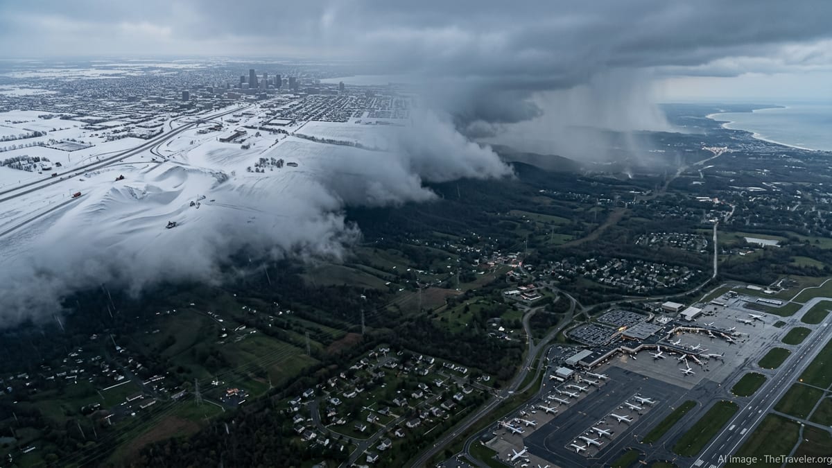
Across these northern states, key interstates and secondary highways have faced closures or severe restrictions, with transportation departments urging drivers to stay off the roads as crews struggle to keep up with rapidly accumulating snow. Images and reports show stranded vehicles along major corridors and travelers taking shelter in service plazas and terminals as the storm continues to churn. Airlines have responded with widespread cancellations and delays at major hubs in Chicago, Detroit and Minneapolis, creating a cascading effect that is snarling connections throughout the country.
Further east, interior New York, Pennsylvania and northern New England are bracing for or already experiencing heavy, wind-driven snow as the storm’s cold sector swings into the region. Forecast discussions highlight the potential for localized totals measured in feet at higher elevations, along with near-blizzard conditions on exposed ridges and passes. Mountain towns that depend on winter tourism are facing a complicated mix of welcome late-season snow and hazardous travel that could keep visitors away during what is normally a busy period.
Reports from rail operators and bus companies point to additional disruptions, especially on long-distance routes crossing the storm’s snowy footprint. Passengers traveling between the Midwest and East Coast have encountered cancellations, significant delays and rerouted services, adding to the number of people stuck far from their intended destinations.
Severe Thunderstorms and Tornado Warnings Hammer the South and Mid-Atlantic
While blizzard conditions dominate the storm’s northern flank, the southern and eastern edges of the system are generating a very different threat profile. According to storm outlooks and live radar summaries shared by national forecast centers and regional media, a volatile warm sector has spread from the Gulf Coast through the Southeast and into the Mid-Atlantic, fueling repeated rounds of severe thunderstorms.
These storms have already produced damaging straight-line winds, large hail and a series of tornado warnings from the Lower Mississippi Valley through parts of Alabama, Georgia and the Carolinas. In several communities, photos posted to social media and local news sites show roofs peeled back, trees snapped and vehicles damaged, indicating that at least some storms have delivered intense localized impacts. Residents across a broad swath of the eastern United States have been urged to monitor warnings closely as additional bands of storms sweep north and east ahead of the cold front.
Farther north into Virginia, Maryland and the mid-Atlantic corridor, forecast discussions point to an unusual early-season overlap of unseasonably warm, moist air and strong upper-level winds. That combination has prompted elevated severe weather risk categories, including the potential for embedded tornadoes within fast-moving squall lines. Urban centers along the Interstate 95 corridor, including Washington and Baltimore, have been preparing for the prospect of sudden, intense wind gusts capable of downing trees and power lines, as well as brief tornadoes that could strike with little lead time.
In coastal areas, the severe thunderstorm threat combines with coastal flooding and rough surf as onshore winds stack water along vulnerable shorelines. Tide forecasts and coastal flood advisories suggest that some low-lying neighborhoods and roadways may face saltwater inundation, even as communities just a short drive inland contend with hail and high winds.
Power Outages, Flight Cancellations and Thousands Stranded
As the storm grinds into its latest day, the cumulative impacts across the eastern United States are mounting. Power outage dashboards and utility statements show hundreds of thousands of customers without electricity from the Great Lakes to the Southeast, with the total fluctuating as new outages occur and crews restore service where conditions allow. Heavy, wet snow in northern states has weighed down branches and lines, while severe winds and tornadoes farther south have snapped poles and scattered debris across distribution networks.
The aviation system is under severe strain. Data compiled from major airline trackers and airport status boards indicate that thousands of flights have been delayed or canceled since the start of the storm period, with fresh cancellations announced as the weather shifts eastward. Travelers attempting to move through key hubs in the Midwest, mid-South and along the East Coast have faced extensive lines, rolling delays and, in many cases, forced overnight stays in terminals or nearby hotels.
Intercity ground travel has fared little better. Bus operators serving corridors from the Midwest to the Northeast report rerouted or suspended services along snow-choked highways and through regions under active severe weather warnings. Some passengers have described extended layovers and crowded waiting areas as routes are consolidated or rescheduled. For travelers attempting to drive, public advisories continue to stress that conditions can change rapidly, with dry pavement giving way to flash flooding, blowing snow or fallen trees within a short distance.
These transportation disruptions are rippling through business and personal plans at the height of a busy late-winter period. Conferences, school events and family gatherings have been postponed or moved online, while tourism-dependent destinations are juggling cancellations and changing itineraries as visitors try to navigate the shifting storm impacts.
Record-Challenging Extremes and Climate Context
The storm’s scale and intensity are drawing heightened attention from meteorologists and climate analysts. Preliminary observations compiled by national weather networks suggest that wind gusts, snowfall rates and temperature contrasts associated with this system are pushing or breaking local daily records in several states. In portions of the interior Northeast, forecasts indicate that snow totals from this event may rival some of the largest late-season storms of the past few decades.
At the same time, the severe weather component in the South and Mid-Atlantic is unfolding against a backdrop of unusually warm, humid air for mid-March. Publicly available climate datasets show that long-term trends in the region include warmer average temperatures and, in many places, an uptick in heavy precipitation events. Researchers regularly note that such trends can influence the intensity and frequency of extreme weather episodes, although they also emphasize that each individual storm is shaped by a complex interplay of atmospheric factors.
Energy demand patterns reflect the storm’s extremes, with some areas in the northern tier seeing elevated heating needs while parts of the Southeast experience conditions closer to late spring. Grid managers and utilities are working to balance these shifting loads in the midst of weather-related outages, a challenge that has become more familiar as volatile patterns swing between cold snaps, severe storms and unseasonable warmth.
For travelers and residents across the affected region, this latest multiday storm has become another reminder of the vulnerabilities exposed when snow, wind, rain and tornadoes converge over a wide geographic area. As the system slowly moves off the East Coast, attention is already turning to cleanup, infrastructure repairs and the likelihood of additional high-impact weather systems in the weeks ahead.