
More news on this day
A sudden, localized cloudburst over Honolulu’s Manoa Valley sent torrents of reddish-brown water racing through streets, parking lots and campus grounds this week, intensifying concerns as Hawaii weathers what publicly available information describes as its most punishing sequence of storms and flooding in more than two decades.
Get the latest news straight to your inbox!
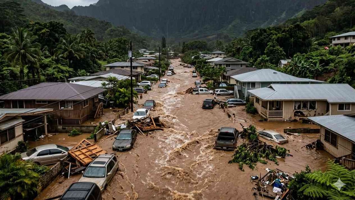
Image by Global Travel Alerts, Advisories, International Travel Alerts
Surprise Downpour Turns Manoa Valley Streets Into Rivers
The latest flooding episode struck on Monday, March 23, when several inches of rain fell in just a few hours over the steep-walled Manoa Valley, a few miles east of downtown Honolulu. Radar imagery and rain gauge data cited in local coverage describe highly localized bursts of 2 to 4 inches of rain per hour, with one upper-valley gauge recording about 6 inches while the Honolulu airport to the west saw only trace amounts.
Publicly shared video and photos from the neighborhood show fast-moving, sediment-laden water surging curb to curb along residential streets, swallowing crosswalks and pouring across driveways. Parked cars that had lined East Manoa Road and adjoining streets were swept from their spaces, some pivoting sideways or bumping over curbs as the runoff deepened.
Reports from the University of Hawaii at Manoa indicate that parts of the campus also flooded, with low-lying parking areas filling rapidly as storm drains were overwhelmed. Social media posts circulated by students and staff describe alerts instructing people to remain indoors while campus crews tried to divert water away from buildings and electrical equipment.
By late afternoon, emergency messaging and local broadcasts were warning residents to avoid the valley unless absolutely necessary, citing rapid rises in Manoa Stream and ongoing flash flooding on feeder roads that connect the neighborhood to central Honolulu.
State Reels From Back-to-Back Kona Lows
The Manoa deluge is the latest blow in a two week span of intense weather that has battered multiple Hawaiian islands. Publicly available information from meteorological agencies describes a pair of strong Kona low systems that parked northwest of the state beginning around March 10, drawing deep tropical moisture over the islands and triggering repeated rounds of heavy rain, thunderstorms and high surf.
In the first phase of the storm cycle, communities on Oahu’s North Shore and parts of Maui and Kauai endured days of downpours that swelled rivers and canals, damaged roads and inundated homes. News reports detail evacuations for thousands of residents in low-lying areas, widespread power shutoffs in flood-prone districts and numerous water rescues as vehicles became trapped in rising currents.
Even as those areas shifted into cleanup mode, another disturbance spun up within the lingering Kona low pattern and targeted Oahu’s south side and interior valleys. The surprise intensity of the Manoa cloudburst, which arrived while many people believed the worst of the weather had already passed, has been cited in national coverage as emblematic of how difficult it can be to forecast exactly where and when the heaviest rain will fall in such complex systems.
Hawaii’s governor has issued multiple emergency proclamations in March tied to the Kona low events, activating state resources and making it easier to mobilize funding and assistance for impacted communities. The statewide emergency framework remains in place as forecasters monitor additional disturbances embedded in the broader storm pattern.
Damage Tallied From Honolulu To The North Shore
In Manoa Valley, preliminary assessments compiled in local and national coverage point to widespread but highly variable damage. Some homes experienced only minor yard flooding and muddy driveways, while others reported water entering ground floors, garages and storage areas as runoff overtopped retaining walls and flowed downslope from the surrounding ridgelines.
Businesses in and around the Manoa Marketplace commercial area contended with flooded parking lots, silt deposits and waterlogged interiors. Photos shared by local outlets show brown water pooling near storefronts and debris gathered around storm drains, suggesting that drainage systems were temporarily overwhelmed by the sheer volume of runoff funneled through the valley.
Elsewhere on Oahu, especially on the North Shore and in rural districts that bore the brunt of earlier storms, public information indicates that hundreds of homes have sustained some level of flood damage since mid March. Raging water has reportedly lifted houses off foundations in certain locations, buried floors and counters under volcanic mud, and carved out roadbeds, leaving some communities temporarily isolated.
Statewide, insurance analysts and government officials cited in recent reporting have estimated that total damages from the March storm sequence could exceed 1 billion dollars when accounting for impacts to infrastructure, schools, hospitals, airports, agricultural lands and private property. That figure would place the 2026 events among the costliest flood disasters in modern Hawaiian history.
Travel Disruptions And Visitor Uncertainty
The cascading storms have also disrupted travel across the islands, complicating plans for visitors arriving at the tail end of Hawaii’s winter tourism season. Flight operations at Honolulu’s Daniel K. Inouye International Airport have remained largely functional, but surface access has at times been slowed by ponding on highways, lane closures and congestion near low-lying interchanges.
On Oahu, reports indicate that some of the most serious road impacts are concentrated in flood damaged corridors on the North Shore and in interior routes that cross mountain passes. Informal guidance circulating among local residents and travel forums in recent days has urged visitors to avoid nonessential driving into hard-hit zones until debris removal and engineering inspections are further along.
Within Honolulu’s urban core and in resort districts such as Waikiki, most hotels and attractions have remained open, though heavy rain, contaminated nearshore waters and the risk of localized flooding have curtailed some outdoor activities. Public advisories have emphasized that conditions can vary dramatically over short distances, with one valley experiencing dangerous runoff while nearby neighborhoods see only moderate showers.
Travel industry observers following the situation note that tourism demand for the islands remains strong, but they caution that the perception of recurring severe weather could influence short term booking patterns, particularly among visitors seeking guaranteed beach conditions and outdoor recreation.
Climate Risks Highlighted As Communities Look Ahead
The March flooding has renewed public discussion in Hawaii about climate related risks, especially the intersection of heavier downpours, aging drainage systems and development patterns in steep valleys such as Manoa. Long standing hazard studies by universities and local agencies have already identified the valley and the adjacent University of Hawaii campus as highly susceptible to flash flooding because of their position beneath rain-catching ridges and the rapid runoff pathways that converge on the stream corridor.
Sea level rise guidance published by Honolulu planners in recent years has also underscored the compounding nature of flood hazards, warning that high tides, intense rainfall and stronger storms can interact to push water into places that historically stayed dry. While the Manoa event was driven primarily by extreme rainfall rather than coastal inundation, analysts point to it as an example of how quickly infrastructure can be overwhelmed when design thresholds are exceeded.
Community conversations documented in local media, neighborhood meetings and online forums reflect a mix of frustration, urgency and resolve. Residents are questioning how stormwater systems, land use rules and emergency communication strategies can be improved to reduce risk in the next major downpour, particularly in areas that have now flooded multiple times in a single month.
For now, forecasters indicate that the most intense phase of the current Kona low cycle is easing, but lingering showers and the possibility of additional disturbances keep the outlook uncertain. As Manoa Valley dries out and debris is cleared from Oahu’s battered roads, Hawaii’s broader challenge is coming into focus: how to adapt a chain of low-lying, mountainous islands to a future in which extreme rainfall and rapid-onset flooding are expected to become more frequent.