
Lahnstein is the sort of place that reveals itself slowly, corner by corner and curve by curve along the riverbank. Straddling the confluence of the Lahn and the Rhine, this compact German town is both a crossroads and a cul de sac, where long-distance hiking trails, rail lines, and romantic castle silhouettes meet quiet residential streets and old town courtyards.
Understanding the layout helps prioritize the main things to do in Lahnstein. Exploring Lahnstein is less about ticking off big-ticket sights and more about understanding its layout: how Oberlahnstein on one side of the Lahn speaks to Niederlahnstein on the other, how the hilltop forests connect to the quays, and how centuries of trade and fortification still shape a simple evening walk. This is a town best understood on foot, by train window, and from the high vantage points of its castles and chapels.
Understanding Lahnstein’s Layout at the Confluence
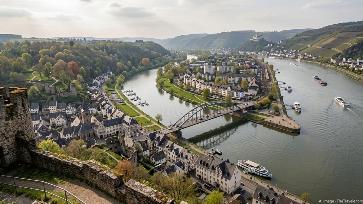
The map of Lahnstein is written in water. The town sits just south of Koblenz, where the smaller Lahn River flows into the Rhine, and that confluence has governed its geometry since Roman times. To picture the layout, imagine the Rhine running roughly north to south. The Lahn approaches from the east, and Lahnstein unfolds on both its banks. The junction of the two rivers is not a vague marshland but a clearly defined point of orientation, with quays, rail lines, and viewpoints that make it easy for visitors to keep their bearings.
Lahnstein is divided into two main districts: Oberlahnstein and Niederlahnstein. Oberlahnstein lies on the southern side of the Lahn, slightly upriver from the confluence, backed by forested hills and overlooked by Lahneck Castle. Niederlahnstein lies to the north and downstream side, where the Lahn meets the Rhine and where the urban fabric blends more directly into the Rhine corridor. Together, the two halves form a single municipality with about 18,000 residents, yet each retains its own street pattern, rhythm, and historical center.
Several bridges knit this geography together. The prominent Rudi Geil Bridge, a steel arch reconstruction dating from the late 20th century on the site of earlier crossings, carries vehicles and pedestrians over the Lahn between Oberlahnstein and Niederlahnstein. There are also rail bridges in the wider municipal area, ensuring that both banks are stitched into the regional train network. Seen from above, the town resembles a hinge, with the rivers as the moving joint and the built-up areas opening on either side.
At this point, many travelers still wonder if Lahnstein is worth visiting or simply a convenient base. For travelers, this dual structure is not a complication but an advantage. It invites you to think of Lahnstein not as a single compact old town but as a small, walkable territory: riverside promenades on both banks, hill trails rising behind each district, and a handful of well-placed vantage points from which to understand how everything fits together. Orient yourself early on by walking or cycling both riverbanks and crossing at least one bridge; your internal map will develop almost immediately.
Oberlahnstein: Fortified Heights and Medieval Streets
Oberlahnstein is the older-feeling of the two districts, with a close-knit old town clustered around former gate towers and remnants of medieval walls. Historically, this southern side developed as a fortified node controlling river trade and land routes, and that defensive heritage is still visible in its compact street layout. Narrow lanes radiate from small squares, with stone and half-timbered buildings set on irregular plots that show how the town grew organically around fortifications, not according to a later grid.
Walking Oberlahnstein, you will quickly notice how the town climbs. Streets fan out from the relatively level riverside up towards the slopes below Lahneck Castle. This topography means frequent shifts in perspective: one moment you are passing a modest residential doorway, the next you look back to find the Rhine gleaming between rooftops. Small stairways and alleys cut between streets, and while the ascents are short, they give the town a vertical dimension that is uncommon in many riverfront communities.
At the urban edge, Oberlahnstein’s built environment gives way suddenly to forest and rock. This is where the layout blurs into the region’s hiking infrastructure. Waymarks for trails such as the Rheinsteig appear alongside local signage, and in a few minutes you can transition from old stone towers to quiet woodland paths. The town’s planning deliberately allows this porous boundary: streets end not in cul de sacs but in trailheads, encouraging daily use of the hills by locals and visitors alike.
In practical terms, Oberlahnstein is where many visitors base themselves if they are drawn primarily to castles and hiking. Guesthouses and small hotels cluster near the old town, while the train station offers straightforward connections toward Koblenz and into the Lahn Valley. For exploration, the key is to alternate between high and low levels: spend a morning wandering the medieval streets and riverfront, then climb to the elevated vantage points to make sense of how Oberlahnstein dominates its section of the Lahn and looks across to the broader Rhine corridor.
Niederlahnstein: Riverfront Terraces and Rail Lines
Niederlahnstein, on the opposite bank of the Lahn and along the right bank of the Rhine, feels more outward-facing. Historically a town in its own right, it gained civic rights in the Middle Ages and later developed strong railroad and industrial links. Today, its urban fabric is defined by linear elements: rail tracks, river promenades, and road corridors that follow the curves of both rivers. The result is a district that feels elongated rather than compact, ideal for long, level walks with water on one side and façades on the other.
The Rhine bank in Niederlahnstein is one of the best places to begin your exploration of the town’s riverine character. The promenade offers close contact with the water, views across to the slopes and castles on the opposite bank, and regular stops for river cruises during the high season. Behind this narrow strip, residential streets and small commercial areas run parallel to the river, with occasional cross-streets leading inland toward the Lahn and the rail station. This linear layout makes navigation simple: the Rhine is your constant reference line, and most amenities are strung out along or just behind it.
The presence of the Niederlahnstein railway station reinforces the district’s role as a transport hub. This separation station lies at the junction of the East Rhine Railway and the Lahn Valley line, with several platforms and track groups fanning out behind the built frontage. The station area anchors the inland side of Niederlahnstein and serves as a key node for day-trippers arriving from Koblenz or continuing further up the Lahn Valley. Trains, buses, and riverboats all converge within walking distance, illustrating how the town’s layout is oriented toward intermodal links rather than a single central square.
Wander inland from the Rhine and you will find that Niederlahnstein’s residential quarters feel quieter and more spacious than the medieval knot of Oberlahnstein. Streets are somewhat wider, building plots more regular, and the overall impression more 19th and 20th century than Middle Ages. Yet there are pockets of older fabric here too, particularly around historic churches and the area where the Lahn and Rhine meet. Together, these layers give the district a subtle depth that rewards unhurried exploration on foot or by bicycle.
Walking the Lahn and Rhine Riverbanks
The riverbanks are Lahnstein’s great unifying feature, linking Oberlahnstein and Niederlahnstein into a continuous waterside landscape. Walking them is both an orientation exercise and an introduction to the town’s daily life. On the Lahn, quieter and narrower than the Rhine, the embankments often feel distinctly local. You pass anglers on folding chairs, small marinas, and stretches of unadorned grass where residents sit with a book or simply watch the water drift toward the larger river.
Following the Lahn upstream from the confluence, you quickly experience the town’s transition to valley. The banks are framed by wooded slopes that grow steeper as you move away from the Rhine, and the built-up area thins to a ribbon of houses and paths. This is where Lahnstein begins to feel like a gateway rather than a destination, introducing the quieter Lahn Valley while still remaining within reach of Rhine shipping and regional transport. The river’s modest width here makes its curve easy to read, and views back to Lahneck Castle confirm your position in the landscape.
On the Rhine side, the atmosphere is different. The river is broad and busy, carrying cargo ships and passenger vessels along the UNESCO-listed Middle Rhine Valley. From the promenades in Niederlahnstein and Oberlahnstein you see the famous pattern of this stretch of river: steep vine-clad slopes, hilltop castles, and small towns facing each other from opposite banks. While Koblenz and the Deutsches Eck are only a short distance upriver, Lahnstein offers a slightly quieter vantage point from which to observe this traffic with fewer crowds.
Connecting the Lahn and Rhine walks is part of the pleasure. You might begin on the Lahn in Oberlahnstein, drift downstream to the confluence, cross to Niederlahnstein over the Rudi Geil Bridge or via another crossing, then follow the Rhine promenade north or south, using the rail stations as natural endpoints. These loops help you internalize how the town’s two halves mirror one another along the water and how the rivers form a dynamic frame for everyday life.
Castles, Chapels, and Viewpoints Above the Town
The vertical dimension is essential to understanding Lahnstein. The town may feel modest at street level, but its surrounding hills are studded with castles, chapels, and viewpoints that have long overseen the junction of the two rivers. Chief among them is Lahneck Castle, a 13th century fortress perched on a rocky promontory high above the confluence. From its walls and towers you can read the entire layout below: Oberlahnstein spread across the slopes, the Lahn threading to the Rhine, Niederlahnstein stretched along the opposite bank, and beyond that the unfolding bends of the Middle Rhine valley.
The ascent to Lahneck Castle illustrates how the town’s built form interlocks with its natural topography. Paths climb from Oberlahnstein’s old streets into mixed forest, sometimes following old defensive lines and sometimes using newer trail alignments. The climb is short but steep enough to make you aware of the town’s elevation shifts, and along the way you glimpse rooftops and river reaches between trees. At the top, the castle complex itself is more than a sightseeing stop. It also functions as a navigational landmark and a reference point in the mental map of both locals and visitors.
Other viewpoints are more modest but equally telling. The Allerheiligenberg, a hill above Niederlahnstein with its chapel and former monastery structures, offers another angle on the town’s geometry. From here you look down not only on the Rhine crossings and quays but also on the way rail lines carve their corridors through the built fabric. The overlap of ecclesiastical sites, transport infrastructure, and residential districts is very clear from this height, and it underscores how Lahnstein’s development has always been a negotiation between spiritual, military, and commercial concerns.
It is also worth noting Lahnstein’s immediate neighbors in the wider landscape of vantage points. To the south along the Rhine, Marksburg Castle above Braubach and Stolzenfels Castle across the river from Lahnstein form a trio of fortifications with Lahneck that collectively dominate this section of the valley. Even when you do not visit each in turn, you see them from promenades, train windows, and hill trails, helping you understand how this entire stretch of river functioned historically as a network of watchpoints and toll stations. Lahnstein’s own castles and chapels are therefore not isolated attractions but integral elements in a larger defensive and cultural system.
Hiking Corridors: Rheinsteig, Ruppertsklamm, and Local Trails
Lahnstein is threaded into one of Germany’s most celebrated long-distance hiking routes, the Rheinsteig. This 320 kilometer trail runs along the right bank of the Rhine between Bonn and Wiesbaden, largely on narrow paths with frequent ascents and descents that capitalize on the valley’s dramatic topography. In the Lahnstein area, the Rheinsteig intersects with the town at multiple points, climbing above the river and dropping back down into the urban fabric via well-marked access paths.
One highlight near Lahnstein is the Ruppertsklamm, a narrow gorge carved by a tributary of the Lahn. The trail through this gorge features steep rock passages and sections where hikers use handrails and ladders, creating a striking contrast with the broad, placid rivers below. It is reached via local paths that begin near the town, emphasizing again how quickly Lahnstein’s residential streets yield to rugged terrain. The fact that such a wild-feeling gorge lies so close to rail stations and river quays is a reminder of how compressed the gradients are in this part of the Middle Rhine region.
The stage of the Rheinsteig that passes from Niederlahnstein toward Braubach gives a practical introduction to how Lahnstein’s layout interacts with the long-distance trail network. Beginning near the old lock island on the Lahn, the route climbs to views of Allerheiligenberg and Lahneck Castle before traversing narrow ridges and forested hillsides. Highlights along the way include historic mining remains and wide terraces above the river. For hikers, this stage is an ideal half-day excursion that starts and finishes at railway stations, turning the town itself into a trailhead.
Beyond the Rheinsteig, Lahnstein is threaded with shorter local routes that link viewpoints, chapels, and residential quarters. Trails with names referencing the Lahnhöhen or Rheinhöhen connect to Lahneck Castle, cross the Lahn Valley, and meet pilgrim routes such as the Lahn-Camino. Many of these paths begin inconspicuously at the end of a street or beside a small chapel, yet within minutes they transport you into quiet woodland with glimpses back to the town geometry. For visitors, these walks are a way to experience Lahnstein’s layout not just in plan but in section, moving up and down the slopes that define its profile.
Moving Around: Trains, Bridges, and Ferries
Despite its modest size, Lahnstein is exceptionally well connected. The town is served by three railway stations: Oberlahnstein on the southern side of the Lahn, Niederlahnstein on the northern side at the junction of Rhine and Lahn lines, and Friedrichssegen further away in the valley. These stations anchor different parts of the urban fabric, and understanding their placement is crucial for planning how you explore. Many visitors arrive via the main regional hub at Koblenz and then continue by local train, stepping off into the town’s walkable core within minutes of leaving a major rail corridor.
The road network supplements the rail system by following the river valleys. Federal road B42 runs along the right bank of the Rhine and ties Niederlahnstein into a string of Rhine towns, while B260 climbs up the Lahn Valley, connecting Oberlahnstein to inland communities. For pedestrians and cyclists, the most important road structure is the Lahn bridge between the two districts. The modern Rudi Geil Bridge provides safe, straightforward crossing of the Lahn, allowing visitors to design simple circuits: old town in Oberlahnstein, confluence walk, then onward to the Rhine promenade in Niederlahnstein and back again.
River traffic plays a quieter but still visible role in day-to-day movement. Passenger boats on the Rhine call at Lahnstein’s quays in season, giving hikers and sightseers a scenic alternative to rail or road when moving between towns. While there is no need to rely solely on riverboats to explore Lahnstein itself, their schedules can shape a day’s outing, perhaps by arriving from a neighboring river town by boat and departing by train after an afternoon of walking. The patterns of cargo traffic on the Rhine and pleasure craft on the Lahn, meanwhile, provide a constant, slow backdrop to exploration.
For the traveler intent on understanding the town’s layout, these transport layers serve as both tools and clues. Each station, bridge, and quay marks a point where corridors converge or cross. Planning your movements around them exposes the underlying structure: how Oberlahnstein relates to the Lahn Valley, how Niederlahnstein opens onto the Rhine corridor, and how the whole town sits within the larger mesh of Middle Rhine transport and tourism infrastructure.
Experiencing Everyday Lahnstein: Squares, Quays, and Neighborhoods
While castles and hiking trails rightly attract attention, the essence of exploring Lahnstein lies in its everyday spaces. Small squares in Oberlahnstein’s old town, framed by historic façades and occasional remnants of fortifications, invite lingering over coffee or a simple lunch. Their irregular shapes tell a story of gradual growth around defensive lines and trade routes, with angles determined more by topography and inheritance than by any formal town-planning scheme.
Along the Lahn and Rhine, modest quays and green strips function as shared front porches for residents. Here children ride bicycles, couples stroll in the evening, and dog walkers make their rounds. Benches are placed toward the water, acknowledging that the rivers themselves are the primary spectacle. Standing at one of these quays, you see both the micro-geometry of Lahnstein’s immediate riverfront and the wider pattern of neighboring towns and castles along the valley, all aligned to the flow of the water.
Residential neighborhoods reveal another side of the town’s layout. On the slopes behind Oberlahnstein’s center, houses are terraced to adapt to the hillside, often with elevated gardens or balconies that capture views toward the rivers. In Niederlahnstein, more level ground allows for broader streets and somewhat more uniform postwar housing developments. Moving between these quarters, you notice changes in building height, street width, and the permeability of paths leading into the surrounding greenery. Each variation reflects a different era of growth and a different relationship to the underlying terrain.
As day turns to evening, Lahnstein’s dual nature becomes more apparent. The castles on the heights may be illuminated, but the strongest sense of place comes from the quiet rhythms at ground level: commuters stepping off local trains, the last river cruise boat calling at the quay, the low murmur of conversation from outdoor tables in front of centuries-old walls. To explore the town thoroughly is to experience both the spectacular viewpoints and these subtle, recurring scenes that tie together the built form, the rivers, and the daily life of its residents.
The Takeaway
Exploring Lahnstein is fundamentally an exercise in reading a landscape shaped by water, hills, and history. The town’s divided structure, with Oberlahnstein and Niederlahnstein facing one another across the Lahn, provides a ready-made framework for discovery. Riverbank walks serve as first lines on your mental map, the bridges and stations as crucial junctions, and the castles and chapels on the heights as reference points that help you keep track of where you are in relation to the valleys and the wider Rhine corridor.
The reward for paying attention to this layout is a richer experience than a simple checklist of sights could offer. By moving deliberately between river level and hillside, between old town lanes and linear promenades, you begin to see how centuries of fortification, trade, rail expansion, and tourism have left their marks in the orientation of streets, the siting of public spaces, and the positioning of trailheads and viewpoints. Lahnstein becomes not just another attractive stop on the Middle Rhine, but a small, comprehensible territory where natural and human geography are unusually legible.
For the traveler with time and curiosity, this legibility is an invitation. Start on the riverbanks, cross the Lahn, climb to the castles, and use the trains and trails as your guides. In doing so, you will not only see Lahnstein’s old towns and riverbanks but also understand how they fit together into a coherent whole. It is this comprehension, more than any single postcard view, that makes exploring Lahnstein a satisfying experience.
FAQ
Q1: How many distinct parts does Lahnstein have, and how do they differ?
Modern Lahnstein has two main districts, Oberlahnstein and Niederlahnstein. Oberlahnstein lies on the southern side of the Lahn and has a compact medieval core beneath Lahneck Castle, while Niederlahnstein sits closer to the confluence of Lahn and Rhine, with a more linear layout along the rivers and stronger rail and transport focus.
Q2: Where is the best place to get an overview of Lahnstein’s layout?
The most comprehensive overview is from Lahneck Castle, which stands on a rocky promontory above the confluence. From there you can see both districts, the meeting of the Lahn and Rhine, the rail lines, and the surrounding hills. The viewpoints on Allerheiligenberg above Niederlahnstein also provide excellent perspectives on the town’s structure.
Q3: Is it easy to walk between Oberlahnstein and Niederlahnstein?
Yes. The districts are connected by bridges over the Lahn, most notably the Rudi Geil Bridge, which carries both vehicles and pedestrians. The distance between the two centers is short enough that most visitors will simply walk, combining a bridge crossing with riverside promenades on each bank.
Q4: How do the riverbanks differ on the Lahn and the Rhine sides?
The Lahn banks feel quieter and more intimate, with smaller paths, marinas, and a strong sense of being in a valley. The Rhine banks are broader and busier, featuring long promenades, river cruise landings, and expansive views of the UNESCO-listed Middle Rhine Valley with its castles and vineyards.
Q5: What role do trains play in exploring Lahnstein?
Trains are a practical and structural backbone for exploration. Niederlahnstein station connects the town to both the Rhine corridor and the Lahn Valley, while Oberlahnstein station serves the southern district. These stations anchor different parts of the layout and make it easy to combine hikes and river walks with short train hops from nearby towns.
Q6: Can I access major hiking trails directly from the town?
Yes. The Rheinsteig, one of Germany’s best known long-distance trails, passes directly through the Lahnstein area, with access paths leading from the town into the hills. The dramatic Ruppertsklamm gorge is also reached from the vicinity, and additional local trails such as the Lahnhöhen and Rheinhöhen routes connect the town to surrounding viewpoints and valleys.
Q7: Is Lahnstein suitable for travelers who prefer gentle walks rather than strenuous hikes?
Very much so. While the surrounding hills offer steep paths for hikers, the riverbanks along both the Lahn and the Rhine are largely level and well surfaced, making them ideal for relaxed strolls. Bridges and rail stations allow you to design routes that match your energy and time, without committing to demanding ascents.
Q8: How does Lahnstein compare to nearby Koblenz for visitors?
Koblenz is a larger city with a denser concentration of museums, shopping, and urban amenities, as well as the well-known Deutsches Eck. Lahnstein, by contrast, is quieter and more intimate, with stronger emphasis on riverside walking, hiking access, and castle viewpoints. Many travelers appreciate Lahnstein as a calmer base from which to explore the Middle Rhine region.
Q9: Are the main sights concentrated in one area or spread out?
Lahnstein’s main sights are spread between the two districts and the surrounding hills. Lahneck Castle and the fortified old streets cluster above Oberlahnstein, while river promenades, churches, and the principal rail junction are in and around Niederlahnstein. Trails and viewpoints are located in the forests and ridges that ring the town, but all are reachable on foot or by short transport links.
Q10: How much time should I plan to understand the town’s layout and main features?
A full day is enough to grasp Lahnstein’s basic structure: morning in one district, an afternoon in the other, and at least one ascent to a castle or viewpoint. Two days allow for a more relaxed pace, including a section of the Rheinsteig or a walk through Ruppertsklamm, plus time to linger along both riverbanks and explore lesser-known residential streets and squares.