
New York State is larger and more varied than many visitors expect, stretching from Atlantic beaches and the Hudson Valley to the Finger Lakes, Adirondacks, and Great Lakes shorelines. Getting around efficiently while still enjoying the scenery takes a bit of planning, especially if you want to balance trains, buses, and unforgettable drives. This guide breaks down the main ways to travel across the state, then highlights some of the most rewarding rail routes and scenic roads for travelers who care as much about the journey as the destination.
Understanding New York State’s Geography and Travel Distances
Before choosing how to get around New York State, it helps to understand its scale. From New York City to Niagara Falls is roughly a full day’s drive with stops, and the Adirondack Park alone covers millions of acres. Distances that look short on a map can involve mountain roads, lake crossings, or two-lane highways where your pace naturally slows. Build generous travel time into your itinerary, especially if you plan to pull over for viewpoints, small towns, and photo stops.
The state’s transportation network generally radiates from New York City and the Hudson Valley, then fans west along the Erie Canal corridor and north toward the Adirondacks and Lake Champlain. Interstates and Amtrak routes often follow historic waterways, while state scenic byways branch off into quieter valleys and highlands. If you are relying on public transportation, you will usually route through New York City, Albany, Syracuse, Rochester, or Buffalo to reach smaller destinations.
Weather is another key factor. Snow, freezing rain, and lake-effect storms are common in late fall, winter, and early spring across upstate regions. In mountain areas such as the Catskills and Adirondacks, conditions can change quickly, and some smaller roads may be icy or temporarily closed. In summer, traffic can cluster around popular recreation lakes and trailheads. Shoulder seasons such as late May or early June and early October often offer a good balance of lighter crowds and vivid scenery.
The good news is that New York State is well set up for travelers who want a mix of convenience and exploration. You can ride fast trains along the Hudson River, connect to regional buses, then rent a car for a few days of scenic driving. Or you can road-trip the whole way, using state scenic byways to turn point-to-point transfers into some of the most memorable days of your trip.
Traveling by Train: Amtrak and Metro-North Across the State
For travelers who prefer to avoid driving long distances, intercity rail is one of the most pleasant ways to cross New York State. Amtrak’s Empire Corridor links New York City with Albany, the Mohawk Valley, the Finger Lakes, and the western cities of Rochester, Buffalo, and Niagara Falls. Many of these trains run along the Hudson River and then the historic Erie Canal corridor, offering open views of water, low-lying farmland, and canal towns that you would miss from the interstate.
Key Amtrak services in New York include Empire Service, which runs multiple times daily between New York City and Albany and continues to cities such as Syracuse, Rochester, and Niagara Falls. Additional named trains like the Maple Leaf follow the same corridor toward Canada, while the Adirondack historically operated between New York City and Montreal via the Hudson and Lake Champlain valleys. Timetables and frequencies can change with track work and seasonal demand, so it is wise to check schedules close to your travel dates and allow extra time for connections.
Within the New York City region and the Hudson Valley, the Metro-North Railroad is a workhorse for residents and visitors. Its Hudson, Harlem, and New Haven lines stretch well into the lower and mid-Hudson Valley and into western Connecticut, with frequent service on most days. Updated timetables for these lines took effect in late 2025, and additional express and “super-express” options have been introduced on certain routes to shorten trips on peak services. As of early 2026, Metro-North is also rolling out a day-pass system that replaces traditional round-trip tickets, offering a modest discount compared with buying two separate peak fares and keeping Connecticut fares flat even as some pass prices rise.
Looking ahead, rail connectivity between New York City and Albany is expected to improve. A new daily Metro-North round-trip between Grand Central Terminal and Albany-Rensselaer has been announced for spring 2026, running along the Hudson Line and continuing north on shared track. This service is being positioned as a slightly lower-cost, commuter-friendly complement to Amtrak, with one-way fares that are expected to start below many comparable intercity tickets. While initial frequency will be limited, the route underscores a broader effort to give travelers more options beyond driving the interstate between the state capital and New York City.
Riding Regional Rail and Transit to Gateway Towns
Many of New York State’s most scenic regions are not directly on mainline rail, but regional trains and transit can get you close. The Hudson Line of Metro-North, for instance, delivers you to river towns like Beacon, Cold Spring, Poughkeepsie, and Hudson Valley communities that function as gateways to hiking areas, wineries, and riverfront parks. In autumn, demand is strong enough that additional weekend trains are regularly scheduled to carry leaf-peepers north from New York City to the Hudson Highlands and beyond.
On the east side of the Hudson, the Harlem Line reaches north to communities such as Brewster, Pawling, and Wassaic, bringing you to rolling farmland and trail networks in eastern Dutchess County. From many of these stations, you can connect to local county bus services or arrange for rideshares and taxis to your lodgings and trailheads. Schedules can be limited on weekends and evenings, so plan station arrival times with a buffer in case your bus or rideshare is delayed.
West of the Hudson, additional commuter rail routes operated in partnership with New Jersey Transit serve Orange and Rockland counties. The Port Jervis and Pascack Valley lines link small cities and towns in the lower Hudson Valley with the wider New York metro area. These lines are useful if you are heading toward the southern Catskills or Delaware River valley and prefer to meet a rental car or local shuttle in a smaller town rather than navigating out of Manhattan by car.
Within upstate cities, regional bus and light-rail systems provide local movement once you arrive. Buffalo has light rail service along a downtown spine, while Albany, Syracuse, Rochester, and other cities operate bus networks that reach universities, museums, and many neighborhoods. While these systems are not designed primarily for tourists, they can be very useful if you base yourself in one city for several days and plan day trips using a combination of local transit and occasional car rentals.
Exploring Major Highways and the New York State Thruway
If your goal is to cover long distances between regions, the New York State Thruway and related interstates form the backbone of overland travel. The Thruway runs from the New York City suburbs north along the Hudson River corridor and then west across the state, generally following the historic Erie Canal route past Albany, the Mohawk Valley, the Finger Lakes, and onward to Buffalo and the Niagara Frontier. It is a toll road, with payments handled electronically for most drivers; rental cars often come equipped with compatible transponders, but visitors should confirm how tolls will be billed before setting out.
Driving the Thruway is efficient rather than romantic. The scenery alternates between forested hills, farmland, and glimpses of river and canal, but service areas and interchanges are designed primarily for speed and safety. If you want to make the drive more interesting, plan short detours off the interstate into nearby canal towns, wine regions, or small cities. For example, exits near Syracuse, Geneva, and Canandaigua put you within reach of Finger Lakes wineries and lakefront promenades with only a modest time penalty.
Interstate 87, also known as the Adirondack Northway in its upper reaches, is one of the more scenic long-distance highways in the state. From Albany north toward Lake George and the Adirondacks, the road climbs into increasingly rugged terrain, with forested slopes and distant mountain views. Traffic can be heavy on peak summer and fall weekends, but the driving itself is comfortable, and pull-offs for viewpoints and trailheads allow you to punctuate the journey with fresh-air breaks.
Elsewhere, interstates such as I-81, I-88, and I-390 connect the Southern Tier, central New York, and western regions in straightforward fashion. They are practical if you have a long distance to cover or need to make a specific connection, such as driving from Binghamton to the Finger Lakes or from Rochester to Letchworth State Park. When time allows, you can exit to parallel state routes and scenic byways that give you a more intimate sense of the rural landscape.
Scenic Drives: Adirondacks, Finger Lakes, Hudson Valley and Beyond
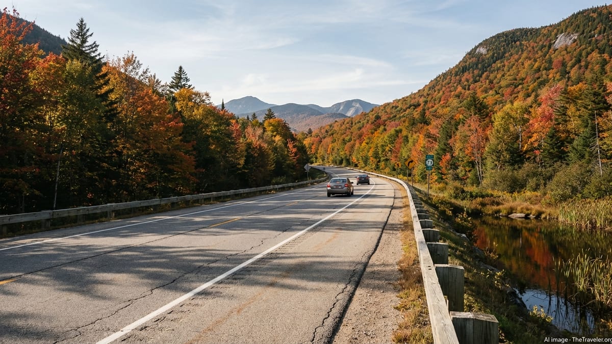
New York’s official scenic byways and informal driving routes turn basic transfers into trip highlights. In the Adirondack region, New York State Route 73 between Lake Placid and Elizabethtown is a classic. The road passes through the High Peaks area, with steep mountains, lakes, waterfalls, and frequent opportunities to pull off for photos or short walks. The corridor is recognized as the High Peaks Scenic Byway and carries travelers past Cascade Lakes, Chapel Pond, and access points to some of the state’s loftiest summits. It is only a few dozen miles long, but many visitors spend several hours on this stretch because of the number of scenic stops and side trails.
Other Adirondack drives include loops off the Adirondack Northway that link Lake George, Schroon Lake, and small hamlets tucked between forested ridges. These roads are generally two-lane and curvy, with modest speed limits that encourage a slower pace. In fall, the foliage can be spectacular, while summer brings views of sparkling lakes dotted with paddlers and small boats. Visitors should be aware that some popular trailheads near the High Peaks now rely on seasonal parking reservation systems to manage crowds, particularly from May through October, and it is worth checking current access rules before assuming you can simply pull in and hike.
Further west and south, the Finger Lakes region is ideal for leisurely road trips. Two-lane state routes such as those along the shores of Seneca, Cayuga, Keuka, and Canandaigua lakes link vineyards, farms, and waterfall-filled state parks. Roads often hug the lakeshore or climb quickly up the surrounding hills, yielding broad views over water and, on clear days, distant ridges. Because these are working rural landscapes as well as vacation destinations, expect slow-moving tractors, cyclists, and local traffic. Building extra time into your schedule makes it easier to enjoy spontaneous winery tastings or side trips to gorges and waterfalls.
The Hudson Valley, easily reached from New York City, mixes practical highways with byways that reward meandering. Routes on both sides of the river connect riverfront towns like Nyack, Cold Spring, Beacon, Kingston, Hudson, and Catskill. Bridges across the Hudson often have impressive viewpoints over cliffs, river islands, and rail lines tracing the shore. State scenic byways also crisscross the Shawangunk Mountains and Catskills, offering access to trailheads, historic villages, and farm stands. Because this region is popular for weekend escapes, starting early in the day can help you enjoy quieter roads and easier parking.
Planning Seasonal Road Trips and Driving Conditions
Seasonality matters a great deal when planning scenic drives in New York State. In late spring and early summer, mountain passes and lake roads are typically clear, waterfalls are running well, and foliage is lush. This is a favorable time for visitors who want long daylight hours and moderate temperatures without peak-season crowds. By mid-summer, popular lake regions and resort towns can be busy, and parking at some trailheads may fill early, particularly in the Adirondacks, Catskills, and Hudson Highlands.
Autumn is arguably the most sought-after season for road-trippers. The Adirondacks, Catskills, Hudson Valley, and Finger Lakes all experience vibrant fall color, often peaking at slightly different times from late September into October as cooler temperatures move south and to lower elevations. Tourism organizations and local media frequently publish foliage updates, which can be a useful reference when deciding which region to visit on a particular weekend. Good weather draws many day-trippers from New York City and neighboring states, so expect heavier traffic on certain weekends and consider booking lodgings and any required parking reservations well in advance.
Winter transforms many scenic byways into gateways for skiing, snowshoeing, and snowmobiling, but it also brings challenging driving conditions. Snowstorms can affect visibility and traction, and some unpaved or secondary roads may not be plowed promptly. Rental cars are typically equipped with all-season tires rather than true winter tires, so it is wise to err on the side of caution, reduce speeds, and avoid night driving in heavy weather if you are unfamiliar with winter roads. Studying your route in daylight, keeping your fuel tank reasonably full, and carrying basic cold-weather supplies such as warm layers and snacks are common-sense precautions.
Spring can be a mixed season, with lingering snow in the Adirondacks and Catskills, muddy shoulders near trailheads, and occasional flooding of low-lying areas near rivers and streams. On the other hand, traffic is often light, and you may have scenic roads largely to yourself. If you plan a shoulder-season trip, check for any seasonal closures of park roads or facilities, and verify that ferries, boat launches, or scenic overlooks that interest you are operating as usual.
Combining Rail and Road for Flexible Itineraries
Some of the most satisfying New York State trips weave together rail journeys and scenic drives. One common approach is to travel by train from New York City to a gateway city such as Albany, Hudson, Poughkeepsie, Syracuse, Rochester, or Buffalo, then pick up a rental car for a few days of exploration. This strategy minimizes the stress of city driving and parking while still giving you independent access to lakes, parks, and back roads once you arrive upstate.
Another option is to use commuter rail for day trips that combine short walks or rides with scenic vistas. For example, you can ride Metro-North’s Hudson Line to river towns with walkable main streets, waterfront parks, and trail connections. From some stations, local shuttles and seasonal trolleys operate on peak weekends, carrying visitors to trailheads, historic sites, or viewpoints without the need for a car. Schedules for these services vary by season, so consider them a bonus rather than the backbone of your itinerary and confirm operating days before you rely on them.
Travelers with more time might design a loop that begins and ends in different cities, using rail in both directions. One scenario is to travel by train from New York City to Albany or Syracuse, rent a car for a road trip through the Adirondacks, Thousand Islands, or Finger Lakes, then drop the car in a western city such as Rochester, Buffalo, or Niagara Falls and return east by train. This structure can reduce backtracking and give you two distinct rail perspectives: one along the Hudson and one along the Lake Ontario or Niagara corridors.
When combining rail and road, pay attention to pickup and drop-off times for rental cars, potential surcharges for one-way rentals, and the location of rental offices relative to train stations. In some smaller cities, rental counters may have limited weekend hours, and taxis or rideshares might be needed to bridge the last mile from the station. Building some flexibility into your schedule will help you adapt if a train runs late or a rental office is busier than expected.
Navigating Tickets, Passes, and Practicalities
Understanding fares and passes can save both money and time as you explore New York State. On Amtrak, ticket prices on routes such as Empire Service and the Maple Leaf typically vary with demand, time of day, and how early you book. Flexible tickets cost more but are easier to change, which can be helpful if your plans depend on weather for hiking or scenic drives. Seat reservations are usually included on longer-distance trains, and busy holiday periods can sell out, so advance booking is strongly recommended for popular weekends and school breaks.
On Metro-North, fare structures distinguish between peak and off-peak travel times, with lower prices for off-peak and weekend trips. From early 2026, a new day-pass format replaces traditional round-trip tickets, generally offering a slight discount compared with buying two peak-period one-way tickets. Weekly and monthly passes remain available for regular commuters, although some have seen fare increases. Many riders now use mobile ticketing apps to purchase and activate tickets shortly before boarding, which is convenient for visitors who do not want to navigate station ticket machines.
For drivers, tolls and parking are the most common extra expenses. The New York State Thruway uses electronic tolling systems, so you will either pay via a personal transponder or, in a rental car, through the company’s toll program, which may include administrative fees. In cities such as Albany, Rochester, and Buffalo, downtown parking is typically easier and less expensive than in Manhattan but may still require payment at meters or garages. In resort towns and near popular trailheads, parking rules can be tightly enforced, with time limits, seasonal reservations, or permit systems in place to manage crowds.
Gas prices, food costs, and lodging rates vary across the state, with generally higher prices in and near New York City and popular resort areas. If you are traveling on a budget, planning fuel stops in larger towns, making use of supermarket delis and local diners, and booking accommodations midweek can help keep overall costs reasonable. It is also a good idea to carry some small bills and coins for rural parking lots and locally operated ferries or shuttles that may not accept cards.
The Takeaway
Getting around New York State is less about one perfect mode of travel and more about combining options to match your interests, time, and comfort level. Trains offer relaxed, scenic routes along the Hudson River and across the state’s historic canal corridor, while local commuter rail and buses bring you within reach of smaller river towns and gateways to the mountains. Highways and interstates provide efficient links between major regions, and official scenic byways transform ordinary drives into experiences filled with lakes, ridgelines, and historic villages.
With a bit of advance planning, you can stitch these pieces together into an itinerary that feels both practical and adventurous. Check current rail timetables and fare options, study seasonal driving conditions, and allow time for detours along scenic routes like the High Peaks Scenic Byway in the Adirondacks or the back roads of the Finger Lakes and Hudson Valley. Whether you are taking your first train north from New York City or embarking on a multi-week road trip from Niagara Falls to Lake Champlain, New York State rewards travelers who treat the journey itself as part of the destination.
FAQ
Q1. Do I need a car to explore New York State outside New York City?
For many regions a car is the most flexible option, but you can combine trains, regional buses, and occasional car rentals to reach major cities, the Hudson Valley, and some resort areas.
Q2. What is the most scenic train route in New York State?
Many travelers consider the Hudson River segment between New York City and Albany particularly scenic, with river views, cliffs, and historic towns visible from both Amtrak and Metro-North trains.
Q3. When is the best time of year for a scenic drive in the Adirondacks?
Late September and early October are often ideal for fall color, though exact timing varies by elevation and yearly weather. Summer also offers clear views and easier driving conditions.
Q4. Are there tolls on major highways in New York State?
Yes, the New York State Thruway and certain bridges and tunnels charge tolls, usually collected electronically. Rental cars often include a compatible system, but fees can vary by company.
Q5. Can I rely on public transportation in the Finger Lakes region?
Public buses exist but are limited for sightseeing, so most visitors rely on cars. You can, however, reach gateway cities like Rochester or Syracuse by train or bus and rent a car there.
Q6. How far is Niagara Falls from New York City by train?
Travel times vary by service and connections, but Amtrak journeys between New York City and Niagara Falls typically take most of a day, so plan on a long, scenic ride rather than a quick hop.
Q7. Is winter driving in upstate New York difficult for visitors?
Conditions can be challenging during storms, especially in lake-effect and mountain areas. If you are unfamiliar with snow driving, choose main roads, slow down, and avoid unnecessary night travel in bad weather.
Q8. Do I need parking reservations near popular Adirondack trailheads?
At some busy High Peaks access points, especially along certain corridors, seasonal parking reservation systems are in place. Always check current rules before your trip to avoid being turned away.
Q9. Are there scenic drives close to New York City for a day trip?
Yes, drives through the Hudson Valley, Catskills foothills, and along both sides of the Hudson River offer rewarding views and historic towns within a few hours’ drive of the city.
Q10. How should I plan for changing train schedules and fares?
Check rail operator websites or apps shortly before your trip, as timetables and fare policies can change. Booking in advance and traveling off-peak usually improves both cost and comfort.