
More news on this day
A sprawling early spring storm system is driving an outbreak of severe weather across the central United States, with Illinois among the states facing a volatile mix of tornado warnings, destructive winds, and large hail that forecasters warn could send dangerous debris airborne and cause widespread damage.
Get the latest news straight to your inbox!
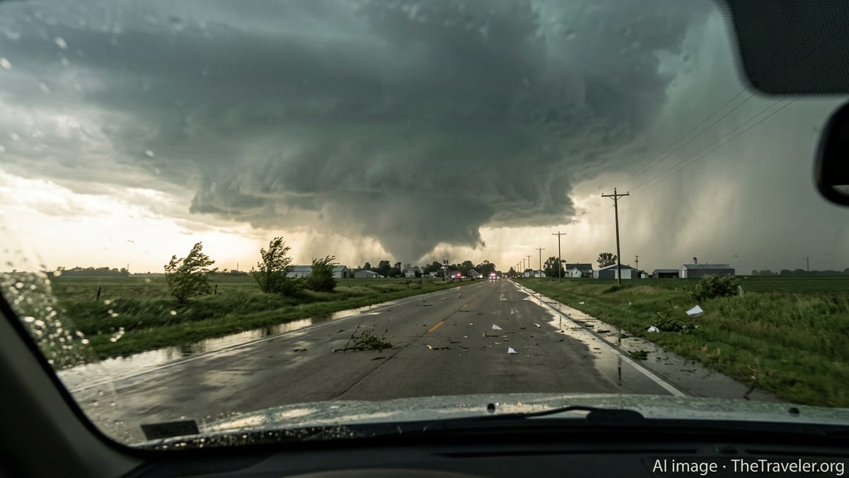
Escalating Tornado Threat Across the Midwest
Forecast discussions and outlooks from federal weather agencies indicate that an unusually dynamic March pattern is setting the stage for multiple rounds of severe thunderstorms from the southern Plains through the Midwest, including Illinois. Energy from a strong upper level disturbance interacting with very warm, humid air at the surface is creating conditions favorable for rotating supercell storms capable of spinning up tornadoes.
Recent days have already seen deadly storms in neighboring Indiana and parts of Illinois, with published coverage describing homes leveled, trees snapped and power lines brought down as tornadoes swept across communities south of Chicago. Early assessments in areas such as Kankakee point to intense winds and potentially record sized hail, underscoring the potency of the current pattern and raising concern about what additional storms could bring as the system shifts east and north.
Model guidance referenced in public outlooks suggests that Illinois sits in a corridor where storms may quickly intensify late in the day, then organize into larger complexes that race eastward overnight. That evolution raises the risk of fast moving tornadoes that are difficult to see after dark, along with broad swaths of damaging straight line winds extending well beyond the immediate storm cores.
Illinois on Alert for Flying Debris and Structural Damage
In central and northern Illinois, including communities between key interstate corridors, multiple rounds of watches and warnings have highlighted the likelihood of tornadoes capable of producing flying debris, roof failures and broken windows. Radar based warning text in recent events has pointed to strong rotation within individual storms, and images shared through local media show shredded structures, overturned vehicles and neighborhoods littered with sheet metal and lumber.
Emergency management guidance disseminated through public channels emphasizes that even tornadoes categorized at the lower end of the intensity scale can loft debris with enough force to be life threatening. In built up areas of Illinois, that risk is amplified by the density of buildings, vehicles and outdoor fixtures that can be pulled into the air. Mobile homes, older farm outbuildings and commercial strips with large glass fronts are of particular concern as the storm line passes.
Published damage summaries from the recent spate of storms in Indiana and Illinois describe scenes where walls were peeled away and interior rooms briefly exposed to the open air. Those accounts, combined with the fresh round of tornado watches and warnings, explain why forecasters are using notably strong language to describe the potential for additional damage as new storms fire along the same general corridor.
Travel Corridors Disrupted by Severe Weather
The outbreak is also posing serious challenges for travelers and freight moving through Illinois and the wider region. Major interstate routes running south of Chicago and across central Illinois lie directly beneath the current severe weather axis, and public information from transportation agencies notes periods of torrential rain, near zero visibility and scattered debris forcing temporary closures or slowdowns.
Recent storm reports have highlighted instances of overturned trucks, jackknifed trailers and vehicles stranded in ditches after encountering sudden crosswinds or hydroplaning on water covered pavement. For long haul drivers and vacationers alike, the combination of high profile vehicles, strong side gusts and blinding hail can be particularly hazardous, especially when storms arrive after dark.
Aviation has also been affected, with severe thunderstorms commonly prompting ground stops and rerouting at major Midwest hubs when lightning, wind shear and low cloud ceilings move overhead. Travelers connecting through regional airports in Illinois and neighboring states are being advised through airline and airport alerts to expect rolling delays as storm cells repeatedly flare along the main jet stream corridor.
Residents Urged to Heed Warnings and Prepare
Publicly available guidance from weather and emergency management agencies stresses that Illinois residents should treat every tornado warning as a signal to take immediate shelter on the lowest level of a sturdy building, away from windows. The recent storms have demonstrated that even brief, radar indicated tornadoes can inflict substantial damage in a matter of seconds, leaving little margin for hesitation once a warning is issued.
Preparedness recommendations circulating through local news outlets focus on having helmets, sturdy shoes, flashlights and a way to receive alerts that does not depend solely on mobile networks, which can become congested or disrupted during widespread severe weather. For families in parts of Illinois that have already experienced one round of storms this month, restocking basic supplies and reviewing shelter plans has become a recurring part of spring.
The sequence of outbreaks in early March has also renewed discussion about the broader trend toward more frequent and costly severe weather events across the central United States. Climate and risk assessments from research groups and government agencies have documented rising losses associated with severe convective storms, including tornadoes and large hail, particularly in states such as Illinois that sit within shifting corridors of springtime instability.
Looking Ahead as Storm Complex Evolves
As the current storm complex continues to evolve through mid March, forecast discussions indicate that the zone of highest tornado potential will gradually migrate east and south, but Illinois is expected to remain under the threat of strong thunderstorms, localized flooding and gusty winds even after the most intense period passes. Additional bands of rain and embedded storms may sweep across the region on the backside of the system, prolonging travel and power restoration challenges.
Analysts tracking recent and ongoing outbreaks note that this month is building on a multi year pattern of active March severe weather across the central and eastern United States, with quick hitting events that strain local response resources and complicate logistics for residents and businesses. For communities in Illinois that have already experienced damage this week, the focus is likely to remain on short term safety, debris removal and securing temporary shelter while the broader recovery picture comes into view.
With the peak of traditional tornado season still weeks away, the early barrage of warnings and destructive storms serves as a stark reminder of how volatile late winter and early spring have become across the nation’s midsection. For now, Illinois and its neighbors remain on edge as forecasters monitor each new storm and residents brace for more sirens, more lightning on the horizon and the ongoing risk of flying debris carried by winds strong enough to reshape familiar landscapes in a single afternoon.