
Lake Superior, the largest of North America’s Great Lakes, feels less like an inland waterway and more like an inland ocean. Its size, shifting moods, and mix of remote cliffs, sand beaches, islands, and working harbor towns give travelers an experience that blends wilderness with maritime culture. From Minnesota’s rugged North Shore to the dunes and waterfalls of Michigan’s Upper Peninsula, the quiet coves of northern Wisconsin, and the sweeping headlands of Ontario, the lake invites slow travel, careful planning, and a willingness to be humbled by water and rock.
The Scale and Spirit of Lake Superior
Lake Superior anchors the northern heart of the continent, its cold waters touching three U.S. states and one Canadian province. It is the largest of the Great Lakes by surface area and among the largest freshwater lakes on the planet. Standing on its shore, travelers often compare it to looking out over the sea, with an unbroken horizon, rolling swell, and weather that can change with little warning. It shapes the climate and culture of hundreds of miles of shoreline, moderating summer heat and intensifying winter storms.
The lake’s personality is defined by contrast. Long reaches of steep, basalt cliffs give way to sheltered harbors, quiet cobble or sand beaches, and low headlands where boreal forest meets water. Inland, the terrain quickly rises into ridges and highlands, cut by rivers that tumble through gorges toward Superior. The result is an unusually dense collection of waterfalls, viewpoints, and trails within a relatively narrow band of land along the shore.
Despite its remoteness, Lake Superior has long served as a corridor of travel. Indigenous communities navigated these waters and portage routes for centuries before fur traders and later ore carriers followed. Today, modern highways trace much of the shoreline, but the lake still retains a sense of frontier. Even within sight of a road or town, the sheer scale of Superior and the rapid onset of fog, wind, or waves remind visitors how quickly a pleasant day can become serious on this inland sea.
Travelers who approach the lake with patience and respect tend to have the richest experiences. That often means building in extra time for weather delays, being flexible about which hikes or boat tours to attempt, and accepting that some days are better spent watching whitecaps from a harbor café than pushing out onto exposed water. Superior rewards that mindset with moments of intense clarity: sun breaking through on wet rock walls, late light on a lighthouse, or the quiet of an empty beach at dusk.
Remote Cliffs, Headlands, and Wild Shorelines
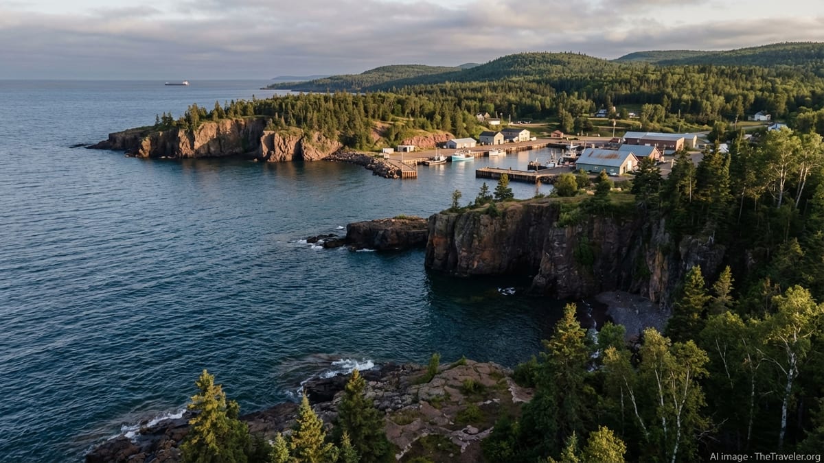
For many travelers, the defining image of Lake Superior is a line of sheer rock dropping directly into deep, cold water. This character shows especially strongly along Minnesota’s North Shore, where lava flows from an ancient rift now stand as dark bluffs and headlands. State parks line this corridor, and some of the best-known viewpoints are only a short walk from parking areas, while longer trails climb inland to ridges with sweeping views over the lake.
Among the most photographed places on Superior is the headland crowned by Split Rock Lighthouse in Minnesota. The state park surrounding it protects miles of rocky shoreline where spruce, fir, and birch cling to thin soil above wave-worn ledges. Farther northeast, additional parks and waysides reveal pocket coves, shingle beaches, and cliff-top overlooks connected by segments of the long-distance Superior Hiking Trail. Hikers can choose short out-and-back walks or commit to multi-day sections that stay within earshot of surf.
On the lake’s south and east sides, cliffs take a different form. In Michigan’s Upper Peninsula, Pictured Rocks National Lakeshore preserves a stretch of multicolored sandstone bluffs rising above the water between Munising and Grand Marais. Here the rock is carved by centuries of wave action into arches, caves, and sweeping overhangs, streaked with mineral stains in shades of red, orange, and green. From above, trails lead to overlooks and waterfalls; from the water, tour boats and guided kayaks reveal the full drama of the formations.
Ontario’s north shore presents yet another face of Superior’s wild side. Long, sparsely developed reaches of coast are punctuated by steep headlands and broad, open views that can feel almost Arctic in mood, especially outside the summer season. Parks and protected areas offer backcountry-style hiking and camping, and the highways are less crowded than those on the U.S. side. For travelers who value solitude and are fully prepared for self-reliant travel, this region offers some of the lake’s most expansive and untamed scenery.
Historic Harbor Towns and Working Waterfronts
Contrasting with the remote stretches are harbor towns that blend maritime history with contemporary tourism. Duluth, at the lake’s western tip in Minnesota, functions as a major inland port, where oceangoing freighters and Great Lakes bulk carriers load and unload grain, taconite, and other cargo. Visitors can watch these ships pass under the town’s iconic lift bridge and follow a lakeside promenade lined with parks, accommodations, and restaurants that make Duluth a natural base for exploring the North Shore.
Smaller communities dot the coasts of Wisconsin and Michigan, each with its own distinct character. On Wisconsin’s Bayfield Peninsula, the town of Bayfield serves as gateway to Apostile Islands National Lakeshore. Its compact downtown climbs a hillside above the harbor, with historic buildings, small inns, and outfitters catering to boaters, paddlers, and hikers. Across an arm of the lake, the village of La Pointe on Madeline Island offers a slower pace, a reminder that ferry-linked communities still live on Superior time, where weather can easily rearrange schedules.
In Michigan’s Upper Peninsula, harbors retain traces of the region’s logging and mining past. Marquette, the largest city on the lake’s southern shore, combines a busy ore-shipping waterfront with a growing outdoor and cultural scene. The town’s preserved loading docks, lighthouses, and waterfront trails put modern recreation and shipping infrastructure side by side. Farther west, communities in the Keweenaw Peninsula, such as Houghton, Hancock, and Copper Harbor, reflect the boom-and-bust legacy of copper mining, with heritage sites and museum exhibits located only minutes from scenic drives and trailheads.
On the Canadian side, towns like Thunder Bay and smaller coastal communities provide essential services for long-distance travelers driving the Lake Superior Circle Tour. Many of these harbors began as fur trade posts or supply points and later became centers for forestry and shipping. Their working character remains visible in grain terminals, sawmills, and commercial fishing docks. At the same time, visitor centers, local galleries, and seasonal festivals highlight Indigenous history, modern art, and regional food traditions, giving a human dimension to the long reach of rock and water.
State Parks, National Lakeshores, and Protected Coasts
Lake Superior’s shoreline is unusually rich in public lands, offering travelers many points of entry into the landscape. In Minnesota, a series of state parks protects waterfalls and river canyons as they drop toward the lake, as well as stretches of pebble beach, cobble shore, and forested ridges. These parks allow visitors to experience Superior’s power in manageable pieces: a short trail to a falls overlook, a campsite above the surf, or a picnic along a sheltered cove that feels far from the road.
The federal government manages some of the lake’s most dramatic terrain through national lakeshores and island parks. Pictured Rocks National Lakeshore in Michigan preserves about 40 miles of shoreline with colorful sandstone cliffs, dunes, beaches, and backcountry campsites. Visitors can hike to viewpoints, take guided boat tours, or join permitted kayak trips when conditions allow. To the west, Apostle Islands National Lakeshore in Wisconsin protects an archipelago of islands and sea caves, along with lighthouses and historic sites linked to maritime navigation and settlement.
Off Michigan’s Keweenaw Peninsula, the Keweenaw Underwater Preserve safeguards waters known for shipwrecks that date to the height of Great Lakes shipping. Recreational divers explore these sites under strict conditions, highlighting how the lake’s cold, clear water preserves wooden hulls and ironwork that would quickly deteriorate elsewhere. Additional underwater preserves around the lake protect further wrecks, acknowledging the risks that mariners have long faced on Superior.
On Ontario’s side, large provincial parks and conservation reserves guard wide sweeps of coastline, inland lakes, and hills. These areas offer a more backcountry-oriented style of travel, with longer hiking routes, backcountry campsites, and a general expectation of self-sufficiency. Travelers venturing into these parks must plan carefully for weather, distances, and limited services, but the reward is a powerful sense of space and a night sky largely free from artificial light, especially outside the brighter midsummer period.
Outdoor Adventures: Hiking, Paddling, and Scenic Drives
Lake Superior invites active exploration, but its size and conditions favor travelers who match their ambitions to their skills. Hiking is among the most accessible ways to experience the lake’s varied terrain. In Minnesota, the long-distance Superior Hiking Trail traces a high route above the shoreline, with access points near communities and state parks. Day hikers can climb to outlooks over river valleys and bays, while backpackers link segments into multi-day trips that stay relatively close to road access if plans need to change.
On the Michigan side, networks of trails in Pictured Rocks National Lakeshore and state parks in the Upper Peninsula connect beach walks, dune overlooks, and river gorges. Brockway Mountain Drive, near Copper Harbor, offers one of the most renowned scenic roads above Superior. The route runs along a ridge more than 700 feet above the lake, with pullouts that reveal broad views of forest, water, and distant islands when skies are clear. Travelers should be aware that this high route can be closed to vehicles in winter, and even in shoulder seasons weather can shift from sun to fog in minutes.
Paddling on Lake Superior demands careful planning and respect for safety guidelines. Portions of the coast, such as Munising Bay near Pictured Rocks or protected channels among the Apostle Islands, see guided sea kayak tours in the main season when conditions are favorable. These trips rely on specialized kayaks, immersion gear, and conservative decision-making around wind and waves. Inland, a network of lakes and rivers near the shore provides more sheltered paddling options for recreational kayaks and canoes, offering a way to experience the Superior region without committing to open-water crossings.
For travelers who prefer the security of a vehicle, the Lake Superior Circle Tour links highways around the entire lake, passing through Minnesota, Wisconsin, Michigan, and Ontario. Drivers can sample different regions with short side trips to waterfalls, lighthouses, and small towns, or commit to the full loop over a week or more. Winter visitors may focus on snowshoeing, cross-country skiing, and watching storms from warm interiors, while shoulder seasons often bring fewer crowds but also more variable weather. Regardless of the activity, flexible itineraries that allow for weather days are vital on this lake.
Weather, Seasons, and Safety on an Inland Sea
Lake Superior’s beauty is tied directly to its challenging weather. Even in midsummer, water temperatures remain low enough to cause rapid cold shock and hypothermia. Air temperatures along the shoreline can be noticeably cooler than inland, and even sunny mornings can give way to fog, sudden squalls, or building waves by afternoon. For travelers, this means checking marine and local forecasts regularly, dressing in layers, and resisting the temptation to underestimate the lake because it sits within a continental interior.
Seasonal changes are particularly dramatic. Summer brings the warmest air, the most stable boating conditions, and the fullest set of visitor services, but also the most visitors at popular viewpoints and harbor towns. Autumn is prized for its fall color along the ridges, as birch, maple, and aspen turn bright against the evergreen backdrop. Scenic routes like the drives along Minnesota’s North Shore or Michigan’s Keweenaw highlands draw photographers and sightseers, though daylight shortens quickly and weather fronts can deliver early snow or heavy rain.
Winter reshapes the lake again. Storms can produce impressive waves and lake-effect snow, especially along the south shore where cold winds pick up moisture over open water. Some communities and attractions pivot to snow-focused activities such as cross-country skiing, snowshoeing, and sled dog events, while others scale back hours or close entirely until spring. Ice cover on Superior varies from year to year, and travelers should avoid venturing onto lake ice unless local authorities specifically confirm safe conditions. Spring often feels like an extended thaw, with lingering snow in the woods even as days grow longer.
Across all seasons, safety on and near the lake is grounded in conservative decisions. Hikers should be prepared with sturdy footwear, extra layers, and maps or GPS, as trails can be slick with rain or spray. Boaters and paddlers should carry proper flotation, cold-water gear, and communication devices, and be prepared to cancel or adjust plans if winds strengthen. On scenic drives, wildlife, sudden fog, and narrow coastal roads call for attentive, unhurried driving. Those who build margin into their itineraries tend to experience the best of Superior’s moods without being forced into risky choices.
Cultural Layers: Indigenous History, Industry, and Modern Tourism
Long before modern harbors and highways, Indigenous nations navigated Lake Superior and its tributaries, developing trade routes, spiritual relationships with the landscape, and detailed knowledge of the water’s moods. Portage paths, fishing grounds, and seasonal camps formed interconnected networks that later fur traders and settlers would partly adopt and partly disrupt. Today, many Indigenous communities continue to live along the shoreline and inland, sustaining cultural traditions, languages, and treaty rights that predate modern borders.
The lake’s more recent history is closely tied to extraction and transport. Fur trade posts evolved into supply depots for logging and mining, particularly in regions like Michigan’s Keweenaw Peninsula, where rich copper deposits drew waves of immigrants and capital. Ore docks, rail spurs, and company towns reshaped the coast in places, leaving a legacy of historic districts, abandoned industrial sites, and repurposed waterfronts. Shipwrecks preserved in cold water testify to the hazards of an industrial era that relied heavily on lake transport for raw materials and finished goods.
Contemporary tourism overlays these older layers without erasing them. Harbor-side museums, interpretive centers, and heritage trails introduce visitors to stories of Indigenous resilience, immigrant labor, and environmental change. Lighthouses converted to museums, restored ore docks, and walking tours of historic downtowns help situate the scenic shoreline within a broader human narrative. Travelers who seek out these interpretive experiences leave with a deeper understanding of how communities have adapted, resisted, and reimagined life around the lake.
Local economies now often balance outdoor recreation, heritage tourism, and ongoing resource industries such as forestry and shipping. This mix can be delicate. Visitor interest provides jobs and supports small businesses, yet it can also strain housing and infrastructure in small towns. Responsible travel on Lake Superior includes not only safety and environmental awareness, but also respect for local community rhythms, from giving space to working docks and tribal fisheries to traveling outside peak hours or seasons when possible.
The Takeaway
Lake Superior defies quick impressions. Its sheer size, variety of shorelines, and mix of quiet coves, steep cliffs, and industrious harbors reward travelers who slow down and let the lake set the tempo. With thoughtful planning, visitors can experience both solitude on a headland trail and the lively energy of a ship passing a harborfront café, often in the same day. The contrast is part of what makes this inland sea so compelling.
Whether traced by car along the Circle Tour, explored in depth from a single base town, or sampled in short excursions tied to hikes and lookouts, Superior demands respect for its weather, waters, and communities. It is a place where flexible itineraries, conservative decisions, and an openness to changing plans lead to better stories than any checklist of attractions. The lake’s most memorable moments often come unplanned: a break in the clouds over distant islands, the sound of waves at night from a campsite, or the quiet in an off-season harbor street.
For travelers seeking a destination that still feels genuinely wild yet woven with human history, Lake Superior offers a rare combination. It is both frontier and familiar, a place of working ports and protected cliffs, remote islands and welcoming small-town main streets. Approached with care and curiosity, this inland sea remains one of North America’s great journeys, tying together remote cliffs, historic harbor towns, and a shoreline where water, rock, and weather are always in conversation.
FAQ
Q1. How long does it take to drive the Lake Superior Circle Tour?
Most travelers spend at least seven to ten days on the full Circle Tour, allowing time for weather delays, side trips to parks, and unplanned stops.
Q2. When is the best time of year to visit Lake Superior?
Late June through September offers the warmest conditions and the fullest set of services, while late September and early October are prized for fall color along the ridges.
Q3. Is it safe to swim in Lake Superior?
Swimming is possible at designated beaches, but the water is cold even in summer, so visitors should limit exposure, stay close to shore, and follow local safety guidance.
Q4. Do I need special experience to kayak on Lake Superior?
Open-water kayaking on Superior requires sea kayaks, cold-water gear, and experience with rough conditions; beginners are strongly advised to join guided trips in more sheltered areas.
Q5. Are there campgrounds close to the lake?
Yes, numerous state parks, national lakeshores, and private campgrounds offer sites near the shore, though reservations during peak summer and fall weekends are often essential.
Q6. Can I visit Lake Superior in winter?
Winter visits are possible and can be rewarding, but services are reduced, roads and trails can be snow-covered or icy, and travelers must be prepared for severe cold and storms.
Q7. Do I need a passport to visit the Canadian side of Lake Superior?
Travelers crossing between the United States and Canada must carry appropriate identification, typically a passport or other accepted border document, and should check current entry requirements.
Q8. How do I watch freighters and ships on Lake Superior?
Ports like Duluth and other working harbors provide safe public viewpoints where visitors can watch large ships enter and exit while staying clear of restricted dock areas.
Q9. Are there opportunities to learn about Indigenous history around Lake Superior?
Yes, museums, cultural centers, guided tours, and interpretive displays in communities around the lake share Indigenous histories, contemporary life, and ongoing treaty relationships.
Q10. What should I pack for a Lake Superior trip?
Layered clothing, waterproof outerwear, sturdy footwear, sun and insect protection, navigation tools, and contingency supplies for weather delays are all important for a safe and flexible visit.