
Luxembourg City is a compact capital with a surprisingly complex map. High plateaus drop into deep river gorges, medieval streets wind beneath sleek glass offices, and the old fortress walls still dictate how you move around town.
For travelers, understanding how the old town, modern districts, and major attractions fit together is the key to making the most of even a short stay. With free public transport across the country, several panoramic viewpoints, and a clearly structured layout of quarters, Luxembourg City rewards anyone who takes a little time to read its urban map before setting out.
Understanding the Layout of Luxembourg City
On a map, Luxembourg City is defined by two river valleys cutting through its heart. The Alzette and the Pétrusse carve deep gorges into the plateau, creating distinct levels of town: the upper city on the cliffs and the lower quarters along the riverbanks.
The historic Ville Haute, or Upper Town, occupies the main plateau and acts as the city’s traditional center, home to the cathedral, government buildings, and elegant squares. Below, districts such as Grund, Clausen, and Pfaffenthal line the water, connected to the top by steep streets, lifts, and bridges. Seeing attractions on a map makes the things to do in Luxembourg City easier to plan.
The city is divided administratively into quarters, but most visitors navigate by a handful of key names: Ville Haute, Gare (the station district), Kirchberg (the European quarter), Belair and Merl to the west, and the valley neighborhoods. Maps help visualize differences when comparing Luxembourg vs Brussels.
Ville Haute links directly to Gare across the Pétrusse valley, while Kirchberg sits on a separate plateau to the northeast, reached via the Grand Duchess Charlotte Bridge and funicular connections. This tiered geography means that distances on the map can appear short, but elevation changes and winding paths often stretch walking times more than in a flat city.
Public transport simplifies the picture. Since March 2020, buses, trams, and regular-class trains have been free of charge nationwide, allowing visitors to treat the city map as an open invitation to hop across quarters without worrying about tickets. Modern tram lines run along the main traffic axis on Kirchberg and extend across the Alzette toward the central quarters, helping to connect business areas, museums, and residential neighborhoods into a coherent urban whole.
The Historic Core: Ville Haute and the Old Town Map
The UNESCO-listed old quarters are concentrated around Ville Haute. On the map, this is the compact rectangle encircled by the remains of fortress walls and bordered by the deep cuts of the Alzette and Pétrusse valleys. Within this area you find Place Guillaume II and Place d’Armes, the city’s two principal squares; the Grand Ducal Palace; the Cathedral of Notre-Dame; and the Municipal Park that traces the line of the former ramparts to the north. The streets are largely pedestrian, and many are laid out in a medieval pattern that makes them ideal for relaxed exploration on foot.
Several official walking routes help visitors interpret the old-town map. The UNESCO Old Town and fortress walk, which can be completed in less than 90 minutes, follows a 2.5 kilometer loop that threads together bastions, viewpoints, and historic streets. Another guided route, often promoted as the Promenade UNESCO, starts near Place de la Constitution, follows the Pétrusse park, ascends to the Chemin de la Corniche, and finishes in the old town. These routes teach you to read the city’s topography as you go, constantly shifting between ramparts, parks, and cliff edges.
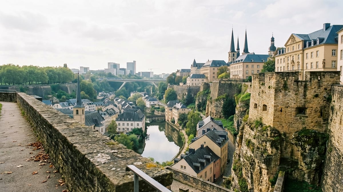
At the eastern edge of Ville Haute, the Bock promontory anchors the map. This rocky outcrop, where Count Sigfried founded Luxembourg in 963, is home to the Bock Casemates, a network of underground galleries dug into the rock. The casemates and surrounding fortifications form the most dramatic visual marker of the UNESCO site, and they also serve as a navigational reference point: walk east from Place d’Armes and you will soon find yourself approaching the Bock and looking down into the valley of the Alzette.
Mapping the Valleys: Grund, Pfaffenthal, and Clausen
The narrow streets and riverfront walks of the lower quarters appear at first like hidden pockets beneath the old town, but they are central to the UNESCO landscape. On the map, the Alzette draws an elongated S-shape through the city, with Grund located directly under the southern cliff of Ville Haute, Clausen stretching east, and Pfaffenthal lying to the north beneath the Bock and the Kirchberg plateau. Each valley district has its own character yet remains visually dominated by looming bridges and fortified cliffs.
Grund is usually the first valley quarter that visitors encounter. Reachable on foot via steep ramps or by a public elevator from the upper city, it unfolds as a calm pocket of stone houses, riverside terraces, and quiet side streets. Looking at a city map, you will notice how the roads in Grund run parallel to the Alzette, rather than following the grid of the plateau above. This linear layout makes it easy to walk from one end of the quarter to the other while enjoying river views and frequent perspectives up toward the Bock and the Corniche.
Pfaffenthal, to the north, connects the city’s old heart with the modern Kirchberg district. The Pfaffenthal Panoramic Elevator links Ville Haute to the valley floor with a glass-walled cabin that offers sweeping views of the Alzette gorge. At the valley level, the funicular at Pfaffenthal-Kirchberg station carries passengers up to the Kirchberg plateau. On a transport map, this combination of elevator, funicular, and tram framework forms a vertical and horizontal spine that allows swift movement between historic and contemporary cityscapes.
Clausen, lying eastward along the river from the Bock rock, reflects the city’s industrial and brewing past alongside new residential and leisure projects. While its streets are closely bound to the curve of the Alzette, bridges and ramps reattach it to the plateau above. Together, Grund, Pfaffenthal, and Clausen illustrate how Luxembourg’s map is more three-dimensional than most European capitals, demanding that visitors think in terms of height as much as distance.
Kirchberg and the Modern Plateau Districts
North of the old quarters, the Kirchberg plateau stretches out as Luxembourg City’s newest face. On the map, this area is easily identified by its straight, broad avenues, large institutional buildings, and the tram line running along the central artery. This is the city’s European district, home to institutions of the European Union, major banks, and contemporary cultural venues. It feels markedly different from the winding lanes of Ville Haute, yet the two are tightly connected by bridges, the funicular, and public transport.
The Place de l’Europe, located near the heart of Kirchberg, acts as a modern counterpart to the historic squares downtown. Around it cluster the Philharmonie concert hall, the European Convention Center, and landmark office towers. From here, it is just a short walk on the map to Fort Thüngen and the Musée Dräi Eechelen, where the story of Luxembourg’s fortifications is told inside restored 18th-century walls. Nearby, the contemporary art museum MUDAM occupies another part of the former fortress landscape, creating a striking dialogue between modern design and historic stonework.
At the western edge of Kirchberg, the Grand Duchess Charlotte Bridge spans the Alzette valley, linking the plateau to the Ville Haute area. From a mapping perspective, this bridge acts as a crucial hinge: cross it on a bus or tram and you move in just a few minutes from business towers and glass facades into the streets of the old city. Furthermore, the integration of Kirchberg into the national rail and tram network means that many travelers arriving from the airport or elsewhere in the country will first read Luxembourg City’s map through the lens of this modern district.
Gare, Belair, and the Western Quarters
Southwest of Ville Haute, the Gare district spreads around Luxembourg’s main railway station. On a city map, it appears as a dense grid of streets bordered to the north by the Pétrusse valley and to the south by residential areas that extend towards the city limits. The station itself is one of the city’s principal transport nodes, linking international and regional trains with city buses and regional bus services. For many visitors, it is the first point of contact with Luxembourg’s famously free public transport system.
Between Gare and Ville Haute, the Pétrusse valley creates a dramatic natural trench. Bridges such as the Pont Adolphe carry vehicles and pedestrians over the gorge, while the landscaped Pétrusse park fills the space below with green lawns, footpaths, and remnants of fortifications. This arrangement makes the map unusually vertical, but in practice it means that travelers can quickly move from busy streets down to shaded walking routes, often with viewpoints back towards the monumental Pont Adolphe or the cathedral towers.
To the west of Ville Haute lies the Municipal Park and the comfortable residential quarters of Belair and Merl. The park traces the line of the demolished fortifications and now stretches as a green arc around the northern edge of the city center. Landmarks here include Villa Louvigny, once home to the forerunners of the modern RTL media group, and Villa Vauban, a museum housed in an elegant mansion that once hosted the early days of the European Court of Justice. The park’s paths serve as a calm alternative route across town, allowing pedestrians to skirt traffic-heavy boulevards while staying close to the central attractions.
Key Attractions and How They Fit on the Map
Luxembourg City’s main sights cluster in a broad band that runs from the Kirchberg plateau, across the Alzette, through Ville Haute, and down into the valleys. Understanding their relative positions makes it easier to design efficient walking or transport-based routes. At the heart of the UNESCO zone, the Bock Casemates dominate the eastern cliff of the old town, overlooking the Alzette valley and the quarter of Grund. Their extensive network of underground corridors, first carved in the 18th century, illustrate why Luxembourg was long known as the Gibraltar of the North. In recent years, the casemates have recorded steadily rising visitor numbers, with more than 200,000 people exploring the site in 2025.
Just south of the Bock, the Chemin de la Corniche runs along the top of the old ramparts, frequently described as one of the most beautiful balconies in Europe. Mapping this path is straightforward: it follows the ridge between the Bock rock and the central squares of Ville Haute, providing a sequence of overviews toward Grund, Pfaffenthal, and the far hills. Nearby, the Cathedral of Notre-Dame and the Grand Ducal Palace punctuate the skyline, both within a few minutes’ walk of Place d’Armes. The palace opens for guided tours during certain periods each year, and its ornate façade is a constant reference point when navigating the old-town lanes.
In Kirchberg, cultural heavyweights such as the Philharmonie, MUDAM, and the Musée Dräi Eechelen line the central axes. The Philharmonie’s elliptical white structure is easily identifiable on aerial and schematic maps, standing near Place de l’Europe and the tram line. MUDAM and the history museum occupy and surround the restored Fort Thüngen, linking contemporary art, historical interpretation, and the broader story of the fortress into a single cluster. Because tram stops lie within short walking distance of each venue, they function together as a straightforward cultural district for travelers reading the city through its public transport map.
Back in the valleys, the Pfaffenthal Panoramic Elevator and the Luxembourg City lifts in Grund provide not only essential connections but also visitor experiences in their own right. The glass-sided Pfaffenthal lift, in particular, has become a favored viewpoint for photographers and casual strollers. By marking these elevators on your personal map, whether digital or printed, you can plan routes that alternate between high and low town without retracing steep climbs, transforming the city’s rugged topography from an obstacle into an asset.
Using Public Transport and Walking Routes
The decision to make all regular buses, trams, and trains free throughout Luxembourg has reshaped the way both residents and visitors use the city map. Instead of calculating fares or passes, travelers simply choose the most convenient route. Bus lines radiate from the central train station and the downtown stops around Ville Haute, reaching all major quarters. The tram, currently running along the Kirchberg plateau and into the central areas, offers a straightforward visual guide for orientation: follow its line and you will always find your way back to the main north-south axis.
For walkers, Luxembourg City’s complexity is part of its appeal. Waymarked routes, including the official UNESCO promenade, guide visitors along cliff edges, through parks, and past key fortification remains. Many of these routes intersect with public transport stops, making it easy to walk one segment of the city and then ride back. The Pétrusse valley paths, for example, allow you to stroll beneath Pont Adolphe and the upper city in a tranquil green setting, then climb back up or catch a nearby bus to continue your itinerary.
Digital maps and city information panels help you visualize vertical connections such as elevators and steep lanes that may not be obvious from a flat map alone. Elevation-aware navigation apps increasingly highlight these features, but local tourist office maps also show stairs, lifts, and viewpoints. Because Luxembourg City’s weather can change quickly and lower valleys can feel cooler and more humid than the plateaus, it is sensible to factor in these microclimates when planning long walks, particularly in shoulder seasons.
The Takeaway
Luxembourg City is a layered place where geography, history, and modern infrastructure intersect on every street corner. What looks on paper like a small capital reveals, in person, a dramatic interplay of cliffs, bridges, rivers, and ramparts that demands a more three-dimensional way of reading the urban map. By understanding how the old town sits on its plateau, how the valleys of Grund, Pfaffenthal, and Clausen weave below, and how Kirchberg and the Gare quarter frame the city to the north and south, travelers can turn a compact destination into a richly varied experience.
With free public transport, clearly signposted walking routes, and a concentration of attractions within a modest radius, the city rewards curiosity more than exhaustive planning. Mark out a few key landmarks such as the Bock Casemates, the Corniche, the Pfaffenthal Elevator, and Place de l’Europe, then use them as anchor points for exploration. In doing so, you will find that Luxembourg City’s intricate map is less a puzzle to be solved than an invitation to move fluidly between eras and elevations, from fortress walls and church spires to contemporary museums and quiet riverbanks.
FAQ
Q1: Is Luxembourg City easy to navigate for first-time visitors?
Luxembourg City is relatively easy to navigate once you understand that it is built on several levels. The historic center is compact, many streets are pedestrian, and free public transport helps bridge distances. The main adjustment for newcomers is dealing with the elevation changes between the plateau and the valley quarters, but elevators, funiculars, and clear signage make this manageable.
Q2: Which district should I stay in to explore the old town on foot?
If your priority is walking access to the UNESCO-listed old town, staying in Ville Haute or just across the Pétrusse valley near Pont Adolphe is ideal. From there, you can reach major sights such as the Grand Ducal Palace, the cathedral, and the Bock Casemates within minutes. The Gare district is also convenient, offering quick transport links and a straightforward walk or short bus ride up to the old town.
Q3: How do I get from the train station to the historic center?
From Luxembourg’s main railway station in the Gare district, you can either walk uphill across Pont Adolphe to reach Ville Haute in about 15 to 20 minutes or take one of the frequent buses heading toward the city center. Both options are free on public transport. The walk is scenic, crossing over the Pétrusse valley with views of the park and fortifications.
Q4: What is the best way to reach Kirchberg and its museums from the old town?
To get from Ville Haute to Kirchberg, you can take the tram or bus across the Grand Duchess Charlotte Bridge, or descend by elevator to Pfaffenthal and use the funicular followed by the tram. All of these services are free and well signposted. Many visitors enjoy combining modes, taking the panoramic elevator to the valley, riding the funicular up to Kirchberg, and returning by tram for a varied experience of the city’s geography.
Q5: Are the Bock Casemates suitable for all visitors?
The Bock Casemates involve underground passages, uneven floors, and some narrow sections, which may be challenging for visitors with mobility issues or severe claustrophobia. However, for most travelers they are accessible with care, and the route is clearly marked. It is advisable to wear sturdy footwear and allow time to move slowly, especially during busy periods.
Q6: How much time should I plan to explore the UNESCO old town and fortifications?
A focused visit following the official UNESCO walking route can be done in around 90 minutes, but most travelers will appreciate at least half a day to include viewpoints, the casemates, the cathedral, and a break in one of the central squares. With a full day, you can comfortably combine the old town, Grund, and at least one of the valley elevators or panoramic routes.
Q7: Is it possible to explore Luxembourg City entirely on foot?
Yes, the central districts and main sights can be explored on foot, especially if you are comfortable with hills and staircases. However, using free public transport can save time and energy, particularly when traveling between the old town and Kirchberg or between the Gare district and more distant neighborhoods. Many visitors adopt a hybrid approach: walk within each quarter and use buses or trams to move between them.
Q8: Do I need to download any specific map app for Luxembourg City?
Most general navigation apps work well in Luxembourg City and show public transport lines and walking routes. However, the official tourist office maps, available in print and online, are specially designed to highlight viewpoints, elevators, and walking circuits, which may not always be obvious in standard apps. Combining a digital map for orientation with a tourist map for sightseeing can be particularly effective.
Q9: Are there good viewpoints marked on the city map?
Yes, several of Luxembourg City’s classic viewpoints, such as the Chemin de la Corniche, the Pont Adolphe area, and the platforms near the Bock rock, are clearly indicated on tourist maps and signposted in the streets. The Pfaffenthal Panoramic Elevator and certain sections of the Municipal Park also offer notable panoramas, making it easy to plan a route that links multiple viewpoints without excessive backtracking.
Q10: When is the best season to explore Luxembourg City’s outdoor attractions?
Spring and early autumn are particularly pleasant, with mild temperatures that make walking the ramparts, parks, and valley paths comfortable. Summer offers long daylight hours and lively terraces but can be busier, while winter brings a quieter atmosphere and, at times, atmospheric mist in the valleys. Regardless of season, it is wise to carry an extra layer, as temperatures can differ noticeably between the sun-exposed plateaus and the shaded river gorges.