
More news on this day
A powerful late-season winter storm is racing across the central United States this weekend, bringing heavy snow, high winds and rapidly deteriorating travel conditions from Green Bay to Kansas City and Omaha, with cities including Marquette, Duluth, Madison and Milwaukee bracing for what forecasts describe as a rare March bomb cyclone.
Get the latest news straight to your inbox!
Rapidly Deepening System Becomes March Bomb Cyclone
Forecast discussions and model guidance indicate that the current storm system is undergoing rapid intensification as it crosses the central Plains into the Upper Midwest, meeting the pressure-drop criteria typically used to classify a bomb cyclone. The low is drawing bitter Arctic air southward while tapping into leftover Gulf moisture, creating a sharp contrast that is fueling heavy precipitation and damaging wind gusts across a broad swath of the region.
Publicly available outlooks show the heaviest snow bands targeting a corridor from eastern Nebraska and Iowa into Wisconsin and the western Upper Peninsula of Michigan. Within this zone, snowfall rates are expected to peak at 2 to 3 inches per hour at times, quickly overwhelming plowing operations and reducing visibility to near zero in open country.
Along the northern and western flanks of the low, a classic wraparound snow shield is taking shape, placing Green Bay, Marquette and Duluth squarely in line for prolonged blizzard or near-blizzard conditions. To the south, a more complex mix of rain, sleet and wet snow is projected for parts of eastern Kansas, northern Missouri and eastern Nebraska as the storm matures.
Green Bay Joins Lakeshore Cities in Blizzard Zone
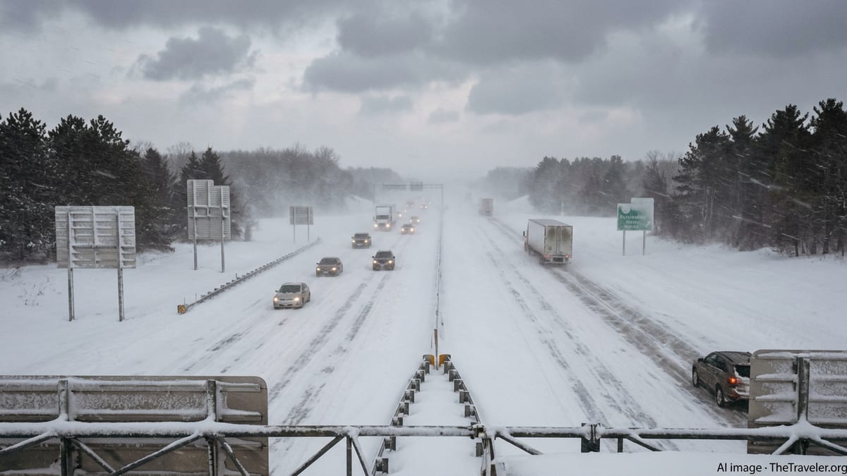
Communities along western Lake Michigan and Lake Superior are emerging as some of the hardest-hit locations. In Green Bay, Madison and Milwaukee, local forecasts call for heavy, wet snow developing from Sunday into Monday, accompanied by sustained winds that may frequently top 30 to 40 miles per hour with higher gusts. This combination is likely to produce whiteout conditions at times on key highway corridors, including routes that connect these cities with Chicago and Minneapolis.
Farther north, Marquette and Duluth are positioned in the colder sector of the storm, where lake-enhanced snowfall could significantly boost totals. As the low passes to the south and east, strong northerly winds are expected to funnel across Lake Superior, piling snow into shoreline communities and amplifying drifting in exposed areas and higher elevations.
Reports from regional media and social channels on Sunday already describe rapidly accumulating snow across portions of Wisconsin, with new bursts of thundersnow signaling intense convective bands embedded within the broader storm shield. Travel conditions are deteriorating quickly on secondary roads, and even major interstates are seeing stretches of significantly reduced speeds as visibility drops.
Omaha and Kansas City Grapple With Hazardous Roads
On the southern flank of the March megastorm, Omaha and Kansas City are experiencing a different but still disruptive mix of weather. Forecasts for eastern Nebraska and western Iowa highlight a period of heavy snow and blowing snow on the cold side of the low, bookended by sleet or rain as temperatures fluctuate around the freezing mark. This transition zone is often associated with icy, rutted highways and fast-changing pavement conditions that catch drivers off guard.
In and around Kansas City, publicly available information points to a sharp gradient in snowfall, with heavier totals likely north and west of the metro area. Nonetheless, strong northerly winds trailing the cyclone are expected to create pockets of blowing snow, especially in open rural stretches leading toward Iowa, Nebraska and northern Missouri. Even where accumulations remain modest, crosswinds and slick bridges may be enough to trigger spinouts and jackknifed trucks.
Regional transportation maps on Sunday show a growing number of weather-related incidents along key trucking corridors from central Kansas into Iowa and Wisconsin. While some routes remain technically open, travel times are lengthening as drivers reduce speed and plows repeatedly cycle through priority interstates and beltways.
Air Travel Waivers and Flight Disruptions Spread
The storm’s footprint is also rippling through air travel across the Upper Midwest. A recently published advisory from a major U.S. carrier outlines a Midwest winter weather travel waiver in effect through mid-March, listing Green Bay, Madison and Milwaukee among the affected airports. The waiver allows eligible passengers to adjust itineraries without change fees when flying into or out of specified cities during the storm window.
Airline operations at regional hubs serving Omaha and Kansas City are preparing for cascading effects from the storm’s strongest phase. As heavy snow and low visibility settle over Wisconsin and the Upper Peninsula, disruptions at mid-continent and Great Lakes airports are likely to ripple across national networks, with delays and isolated cancellations appearing even at airports outside the core blizzard zone.
Travelers connecting through the region are being urged in public advisories and airline bulletins to monitor flight status frequently and to anticipate last-minute gate changes, rolling departure pushes and extended time on the tarmac for deicing. With the storm coinciding with a busy March travel period, terminal congestion is expected to build at several midwestern airports as passengers seek rebooking options.
Guidance for Road Trippers and Winter Travelers
For travelers on the ground, transportation agencies and weather services across the affected states are emphasizing the rapid pace of deterioration that can accompany bomb cyclone conditions. Forecasts highlight the risk that roads which appear merely wet in the morning may become icy and snow-packed by afternoon as temperatures drop and wind-driven snow begins to stick and drift.
Drivers planning trips between Green Bay, Madison, Milwaukee, Duluth and Marquette are being encouraged through public messaging to build contingency time into itineraries, carry full winter emergency kits and consider postponing nonessential travel during the storm’s peak. Routes connecting Omaha and Kansas City to the Upper Midwest via Iowa and Minnesota may be particularly vulnerable to closures or rolling travel advisories as conditions change from hour to hour.
Rail and intercity bus passengers may also experience knock-on delays as operators respond to drifting snow on tracks, frozen switches and poor roadway visibility around depots and transfer points. Published service updates suggest that some schedules are being adjusted proactively to reduce the risk of vehicles becoming stranded between stations or along rural stretches of highway.
With snow still falling and the low continuing to deepen over the Great Lakes, the full extent of the March megastorm’s impact on transportation will not be clear until later in the week. For now, travelers across the central United States are facing another round of winter chaos, just as many had begun to look ahead to spring.