
More news on this day
A volatile clash of warm, humid air and late-season Arctic cold is triggering new tornado watches and heavy snow across large parts of the United States this weekend, creating hazardous conditions for travelers by air and road and prompting fresh weather alerts from the Midwest to the Mid-Atlantic.
Get the latest news straight to your inbox!
Severe Storms and Tornado Risk Expand Across Eastern U.S.
Publicly available forecasts indicate that a broad area from the mid-South into the Ohio Valley and Mid-Atlantic faces an elevated risk of severe thunderstorms and possible tornadoes from late Sunday, March 15, into Monday, March 16. Coverage from national and regional outlets highlights the potential for fast-moving squall lines with damaging winds, hail and a few tornadoes tracking east from the Mississippi Valley toward major population centers.
The pattern follows a series of tornado outbreaks earlier in March that affected portions of the Southern Plains and Midwest, including destructive storms in Oklahoma and Michigan between March 5 and 7 and additional activity over the central United States between March 10 and 12. Historical summaries show that those systems produced multiple fatalities, structural damage and localized power outages, underscoring the vulnerability of road traffic and aviation when springlike severe weather arrives early.
Today’s setup features strong upper-level winds overspreading warm, moisture-rich air surging north from the Gulf of Mexico, a combination that can quickly organize thunderstorms into lines and embedded rotating cells. Meteorological outlooks point to the highest tornado and damaging wind potential stretching from parts of the lower Mississippi Valley into the Tennessee and Ohio valleys, then shifting toward the Mid-Atlantic corridor, including cities such as Nashville, Cincinnati, Pittsburgh and Washington, D.C.
Travelers in the risk zone should be prepared for rapid changes in conditions, with clear skies giving way to intense thunderstorms over a short time. Lightning, brief but intense downpours, destructive straight-line winds and isolated tornadoes can all force temporary closures of interstate highways, while low cloud ceilings and wind shear frequently trigger ground stops and delays at regional and major hubs.
Late-Season Snowstorms and Blizzard Conditions Hit the North
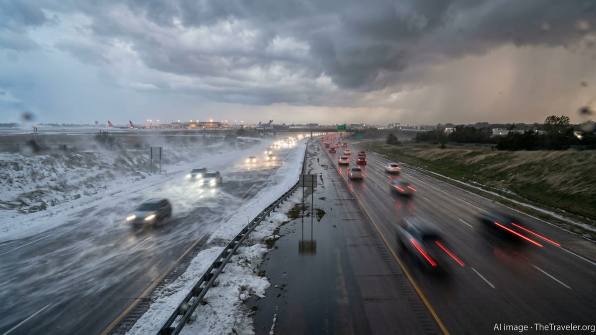
While severe thunderstorms and tornado threats intensify in the East, multiple winter storm systems continue to hammer the northern tier of the country. Forecast discussions and private-sector outlooks describe two powerful storms sweeping across the Northern Plains, Upper Midwest and Great Lakes between March 11 and March 15, bringing periods of heavy snow, strong winds and near-blizzard conditions to some areas.
Earlier in the month, a strong clipper-type system dropped fresh snow from the Midwest into the Mid-Atlantic, and a separate historic blizzard in late February delivered crippling accumulations and whiteout conditions across portions of the Northeast. Reviews from meteorological agencies and media coverage note that these events temporarily shut down sections of key highways, prompted “no travel” advisories in parts of Minnesota and led to power outages where heavy, wet snow and high winds stressed the grid.
More recently, winter storm watches in the northern Rockies and northern Plains have highlighted the risk of two to four feet of mountain snow and gusts exceeding 40 to 50 miles per hour in exposed passes, especially along portions of U.S. Highway 2 in Montana. In the Great Lakes region, additional snow tied to the current storm sequence is combining with strong winds to create blowing and drifting, reducing visibility and complicating road-clearing operations ahead of the workweek.
For drivers, the mix of accumulating snow, drifting and patchy ice means rapidly changing traction and visibility, especially after dark. For airlines, extended bands of snow and crosswinds can lead to deicing delays, runway capacity reductions and diversions at airports from Denver and Minneapolis to Chicago, Detroit and Buffalo, even when individual snowfall rates appear moderate.
Air Travelers Face Waivers, Cancellations and Rolling Delays
The combination of tornado risk and snowstorms is already rippling through the aviation network. Published travel advisories from major carriers describe weather waivers for both thunderstorms around Chicago in the middle of last week and fresh winter weather across the Midwest from March 14 to March 16, allowing affected passengers to rebook without change fees within specified dates.
National coverage of recent and ongoing winter storms notes that large systems in January and February caused cascading disruption across the country, with hundreds to thousands of flights canceled or delayed on peak days as snow, ice and high winds swept from the Plains through the Midwest and into the Northeast. Reports from previous events suggest that even airports outside the heaviest snow zones can experience secondary impacts as aircraft and crews are displaced.
Forecasts for this latest multi-hazard pattern point to potential issues at a wide range of hubs, including snow and crosswinds at northern airports, convective storms and turbulence along busy east-west corridors, and low ceilings in the Mid-Atlantic as squall lines pass through. Travelers booked over the next several days are being urged by airlines and weather information services to monitor their flight status frequently and to make use of flexible rebooking options where available.
Those who must travel by air during active alerts should plan for longer airport dwell times, as security lines and boarding processes often slow during waves of delay. Packing medications, chargers and essential items in carry-on bags rather than checked luggage can help mitigate the impact of missed connections or unexpected overnight stays caused by weather-related disruptions.
Road Travel: Hazardous Corridors and Timing Your Trip
For those on the road, the current wave of storms presents several high-risk corridors. In the North, stretches of interstate and U.S. highways across the Dakotas, Montana, Minnesota, Wisconsin and Michigan are expected to see periods of heavy snow, blowing and drifting, along with occasional full closures where conditions deteriorate rapidly. State transportation agencies in recent storms have closed or restricted key routes such as Highway 61 along Lake Superior when visibility dropped to near zero and plows could not keep up.
Farther south and east, forecasters and transportation bulletins point to hazardous driving conditions from intense thunderstorms, ponding on roadways and sudden crosswinds across parts of the lower Mississippi Valley, Tennessee Valley and Mid-Atlantic. Short-lived but severe squall lines can down trees and power lines onto roadways, scatter debris and create unexpected obstacles at highway speeds, particularly after dark.
Timing remains critical. Travelers who have flexibility are being advised by weather services and emergency planning guidance to avoid driving during the peak of winter storms or along the leading edge of severe thunderstorm lines. Shifting a long drive into mid-morning or early afternoon, after road crews have had time to treat priority routes or after squall lines have passed, can substantially reduce exposure to the worst conditions.
Motorists who must drive regardless of the forecast are encouraged by safety campaigns to keep their fuel tanks at least half full, carry cold-weather gear and traction aids in snowy regions, and treat any downed power lines or flooded underpasses as hazards to be avoided, not navigated. Even in areas where accumulations are light, a quick glaze of freezing rain or slush can turn bridges and overpasses into slick spots with little warning.
What Travelers Should Do Now
With severe thunderstorms, tornado potential and snowstorms unfolding almost simultaneously across different regions, travel experts emphasize preparation, flexibility and real-time information. Public bulletins from meteorological agencies recommend that people in affected areas review local tornado and winter weather safety guidance before conditions deteriorate, so that they know where to shelter and how to respond if watches or warnings are issued.
Air travelers planning departures or connections through the central and eastern United States over the next several days can benefit from building additional buffer time into itineraries and avoiding the last flight of the day where possible. Monitoring airline apps and airport operations pages on the day of travel remains essential, since ground stops, reroutes and rolling delays are often announced on short notice in evolving weather.
For road trips, mapping services and state transportation websites provide live updates on closures, chain requirements and crash reports. Checking these resources before departure and at fuel or rest stops can help drivers reroute around emerging trouble spots. If forecasts trend worse on the day of travel, postponing nonessential trips may be the safest option.
Although the current pattern is notable for the breadth of hazards in play at once, climatological analyses show that March is historically a period of rapid swings between winter and spring across the United States. That volatility often translates into complex travel challenges. For now, those who stay informed and make conservative choices around timing and routing stand the best chance of reaching their destinations safely.