
Few natural landmarks are as instantly recognizable as Niagara Falls. Straddling the border between the United States and Canada, this thundering sweep of water has inspired Indigenous stories, powered early industry, dazzled honeymooners and still manages to stun even the most seasoned travelers. Understanding its deep history, staggering physical scale and constantly evolving visitor experience only makes a trip to Niagara Falls more rewarding.
The Making of a Natural Icon
Niagara Falls is not a single waterfall but a trio of cascades carved into the Niagara River, a short waterway that connects Lake Erie with Lake Ontario. The river forms part of the border between New York State and the province of Ontario, and along a relatively small stretch of its course, the water encounters a band of hard rock that resists erosion. Where that rock gives way to softer layers beneath, the river plunges over an abrupt step. Over thousands of years, that step has retreated upstream, creating the broad amphitheater of cliffs that define the modern falls.
Geologists trace the birth of Niagara Falls to the end of the last Ice Age, roughly 12,000 years ago, when retreating glaciers reshaped the Great Lakes basin. As meltwater filled the newly formed lakes, it sought lower outlets to the Atlantic Ocean. The Niagara River emerged as one such outlet, cutting through layers of ancient sedimentary rock. The harder caprock on top, mostly dolostone and limestone, erodes slowly, while the softer shale underneath erodes more quickly, causing the cap to crack and collapse. That ongoing process is why the falls have gradually migrated upstream from their original location.
Over millennia, the power of falling water has excavated the deep plunge pools at the base of the cliffs and the steep-walled Niagara Gorge downstream. The gorge extends about 7 miles from the falls to where the river widens on its way to Lake Ontario. For visitors today, this visible record of erosion provides a rare opportunity to see geological time in cross-section, as layer upon layer of rock, some more than 400 million years old, is exposed in the gorge walls.
Erosion rates have not been constant. Before human intervention, the brink of the falls was retreating at an estimated pace of several feet per year. Modern diversions of water for hydroelectric power and international agreements regulating flow have slowed that rate considerably. Even with those controls, Niagara remains a living landscape, subtly reshaped each season by winter ice, spring floods and the constant grinding force of waterborne rock fragments.
Three Different Falls, One Immense System
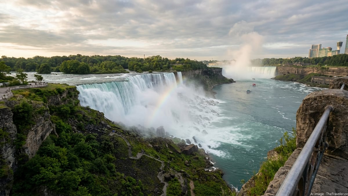
What most people casually call “Niagara Falls” is actually a system of three neighboring waterfalls. The largest and most iconic is Horseshoe Falls on the Canadian side, named for its sweeping curved crest. To the north lie American Falls and the smaller Bridal Veil Falls, both entirely within the United States. Seen together from many viewpoints, they read as a single dramatic curtain of whitewater, but each has its own dimensions and character.
Horseshoe Falls is the giant of the group. Its drop is often cited at around 50 to 57 meters, or roughly 160 to 188 feet, depending on water levels and how the height is measured. The crest stretches for some 670 to more than 790 meters, giving the falls an unmistakable arc of turquoise water framed by mist. The deepest part of the river lies just below this cascade, where the plunging water has scoured a basin as deep as the falls are tall, adding to the drama of the scene.
American Falls, closer to the New York shore, offers a different spectacle. Here the height of the falling water is partly obscured by a jumble of boulders at its base, the product of past rockfalls. Measured to the top of this rocky talus, the drop ranges from about 21 to 34 meters, or 70 to 110 feet. If measured all the way to the river surface below, the total height is comparable to Horseshoe Falls, but the cascade breaks into many smaller streams as it tumbles over the angular rocks, creating intricate patterns of whitewater.
Between American Falls and Goat Island, the narrow ribbon of Bridal Veil Falls descends in a thinner, more delicate sheet. It is significantly narrower than its neighbors, only on the order of a few dozen meters wide, but almost as tall. Because visitors can approach it closely on wooden walkways, Bridal Veil Falls often feels the most intimate, with fine spray and roaring sound surrounding those who venture near. Together, these three waterfalls form one of the largest waterfall complexes on Earth in terms of both width and flow volume, easily rivaling better-known giants in Africa and South America.
Sheer Scale: Water, Height and Power
Trying to grasp the numbers behind Niagara Falls can be as dizzying as staring into the mist from the brink. At peak daytime flows during the main tourism season, hundreds of thousands of gallons of water surge over the combined falls every second. On an annual basis, the average flow rate of the Niagara River as it passes the falls is measured in thousands of cubic meters per second. Exact figures vary with lake levels and how much water is temporarily routed through hydropower facilities, but it is safe to say that the system moves water at a rate that is hard to visualize.
One way to picture it is to imagine Olympic-size swimming pools. Rough estimates suggest that every minute, the equivalent of many dozens of such pools empty over the cliffs. That torrent originates in the upper Great Lakes, with water from four of the five lakes eventually making its way down the Niagara River before reaching Lake Ontario and, ultimately, the Atlantic Ocean. Because the Great Lakes collectively hold nearly one-fifth of the world’s unfrozen fresh surface water, the falls are essentially fueled by one of the planet’s great natural reservoirs.
The height of the falls, while not the tallest in the world, becomes more impressive in the context of this huge volume. Unlike narrow, plunging waterfalls that drop from immense heights, Niagara presents a broad, muscular wall of water. This combination of width and depth means that the sound, vibration and spray are all magnified. Standing near the brink, visitors feel the ground subtly tremble; even at a distance, the thrum of the falls can drown out conversation.
Niagara’s energy has long attracted engineers as much as sightseers. Since the late 19th century, the falls have powered some of North America’s most important hydroelectric projects. Early schemes were crude and controversial, but they paved the way for modern facilities on both banks that now generate a significant share of the electricity used in Ontario and New York State. To limit erosion and balance power generation with tourism, regulators divert a substantial proportion of the river’s flow through turbines, particularly at night and in winter. Even so, enough water is left running over the cliffs to preserve the sense of overwhelming natural force that has made Niagara famous.
From Indigenous Homeland to Industrial Frontier
Long before tour buses and honeymoon suites, Niagara was a sacred landscape for Indigenous peoples. The region around the falls and along the river has been home to communities including the Haudenosaunee (Iroquois Confederacy) and other First Nations and Native American groups. The river served as a travel corridor, a fishing ground and a source of spiritual stories that explained its power and danger. While many of those stories were later romanticized or distorted by outsiders, they testify to a deep, longstanding relationship between people and place.
European explorers and missionaries began reporting on the falls in the 17th century, amazed by their size and fearful of their hazard to navigation. As colonial settlement expanded, Niagara became an important strategic frontier. The river and its crossing points played roles in multiple conflicts, including the War of 1812, with forts and batteries dotting the banks. Only gradually did visitors begin to come for pleasure rather than war or commerce, sketching romantic views of the mist and cliffs.
By the 19th century, Niagara Falls was emerging as a symbol of the sublime in North American art and literature, representing both the beauty and the raw power of wilderness. Painters and writers framed the falls as a place where visitors could feel humbled and renewed, a counterweight to the smoke and clatter of growing industrial cities. At the same time, however, industry was tightening its grip on the river. Mills, factories and power stations crowded the gorge, harnessing water to drive machinery and lights. The landscape around the falls became a patchwork of private attractions, hotels and industrial sites.
This tension between preservation and development sparked one of the continent’s earliest organized conservation efforts. Reformers argued that the falls and their surroundings should be protected for public enjoyment rather than left to piecemeal commercial exploitation. Their campaigns contributed to the creation of protected parklands on both sides of the border, including what is often cited as the oldest state park in the United States. These early victories helped establish the idea that extraordinary natural wonders deserved to be conserved for all, a principle that would later guide the national park movement.
A Cross-Border Destination in Constant Evolution
Modern visitors encounter Niagara Falls as a polished, highly managed destination that still retains room for wildness. On the American side, New York’s state park lands emphasize green space, footpaths and views framed by islands and forest. On the Canadian side, the parkway is lined with gardens, lawns and a dense strip of hotels and attractions that overlook Horseshoe Falls. The two sides are linked by bridges, with border controls that remind travelers they are moving between two countries even as they share the same river and spectacle.
Year-round, tourism infrastructure works quietly in the background to make such visits possible. International agreements specify how much water must go over the falls during peak viewing hours, ensuring the sight remains impressive even while power plants draw off large volumes. Engineers monitor rock stability, anchor exposed ledges and periodically rebuild walkways and viewing platforms that ice and spray gradually degrade. Light shows after dark, seasonal fireworks, and special events layer a human-made sense of drama over the already formidable natural scene.
The falls themselves, though, continue to change. Winter can coat nearby trees, railings and buildings in thick ice as spray freezes in frigid temperatures, creating a crystalline landscape that looks otherworldly but reflects ordinary meteorology. Contrary to popular myth, the falls rarely if ever freeze solid; instead, ice bridges sometimes form on the river below, and ice formations can partially mask the flowing water. Spring and early summer often bring higher flows, while late summer and fall can offer clearer skies and warmer viewing conditions.
Visitor numbers fluctuate with economic cycles and global events, but Niagara remains one of North America’s most-visited natural attractions, drawing millions annually from around the world. The dual-city setting, with Niagara Falls, New York, and Niagara Falls, Ontario, facing each other across the gorge, adds cultural variety. Visitors can experience contrasting perspectives by crossing the border, from quieter trails and overlooks on one side to a more urban resort skyline on the other, all within sight of the same unifying wall of water.
What It Feels Like to Stand at the Brink
Statistics and diagrams can only go so far in explaining Niagara’s enduring appeal. The emotional impact of the falls is rooted in sensory overload. Approach from upstream and the river first seems broad but relatively calm, dotted with small islands. As you near the brink, the water gathers speed, sheets stretch tight and glassy, and the sound ramps from murmur to thunder. Fences and railings keep visitors a safe distance back, but the psychological jolt of seeing all that water lunge into empty space just a few steps away is undeniable.
Sound is one of the defining features of the experience. Depending on wind direction and water flow, the roar can be so loud that it becomes almost a texture rather than a noise, a physical presence in the air. Conversation drops to shouted fragments; many people fall silent altogether. Mist rises continuously from the base of the falls, drifting downwind to soak clothing and camera lenses. On sunny days, rainbows form and fade in the spray, a visual reminder of the water droplets suspended in the air between viewer and cliff.
For many visitors, the most vivid memories come from vantage points that change their perspective on the falls. Boarding a boat that navigates into the basin below, guests feel the swell and chop of the river as they approach the curtain of water. The closer they come, the less they can see, until everything dissolves into white mist and rushing sound. Elsewhere, walkways that descend partway down the gorge walls or behind sections of Horseshoe Falls let people experience the force of water from underneath and behind, where individual streams become a continuous vibrating wall.
Even simple moments can be unexpectedly moving. Watching the river at night, when floodlights illuminate the falling water in shifting colors, or standing at a quiet overlook at dawn before tour groups arrive, travelers often describe a sense of awe that is difficult to put into words. Part of that reaction may stem from an intuitive grasp of scale: the knowledge that the water flowing past your feet has traveled hundreds of miles across multiple lakes and will continue on to the ocean long after you have gone.
Why Niagara Still Amazes in the Age of Screens
In an era when travelers can watch high-definition videos of almost any place on Earth, it might seem that the shock of the new has been blunted. Yet Niagara Falls continues to impress in person, even for visitors who have seen it countless times on screen. One reason is that video rarely captures the full sensory range of the site. Cameras flatten depth and mute sound; they cannot convey the feel of spray on skin or the subtle trembling of the ground. Standing at the railing, the three-dimensional reality of the gorge and the continuous movement of water create a sense of presence that digital media still struggles to replicate.
Another reason is that Niagara offers more than just a single viewpoint. It rewards repeated visits and exploration. A traveler might first see the falls head-on from a main overlook, then walk along the rim to appreciate how the river narrows and quickens, then cross to the opposite shore for a completely different composition of cliffs, skyline and spray. Descending into the gorge, the scale of the cliffs becomes more apparent; looking back from a boat, the human-built observation towers and hotels seem small against the sweep of rock and water.
The falls also sit at the intersection of nature and culture, which gives them layers of meaning. Travelers come not only for the scenery but also for the stories tucked into it: tales of tightrope walkers and barrel-riders who challenged the river, of engineers who tamed some of its power for electricity, of couples who chose Niagara as a backdrop for milestones in their lives. Even those who have little interest in such history feel the weight of human attention that has accumulated here over centuries.
Perhaps most importantly, Niagara embodies a reassuring constancy in a changing world. While weather, water levels and development shift its appearance, the basic drama of the river plunging over the cliff endures. Visitors returning after many years often find that the details have changed but the core experience feels the same. That continuity, combined with the sheer physical energy on display, helps explain why the falls remain a must-see stop on countless itineraries through the northeastern United States and eastern Canada.
The Takeaway
Niagara Falls is more than a postcard view. It is a dynamic geological feature shaped by ice ages and erosion, a cross-border symbol of early conservation and industrial innovation, and a stage for the timeless play of water and gravity. Understanding its three-part structure, its immense but carefully managed flow, and its deep historical roots enriches the experience of standing on its mist-swept edges.
For travelers, the appeal lies in both the spectacle and the setting. In a single visit you can watch the river gather at the brink, feel the vibration of the plunge, explore manicured parklands and urban skylines, and contemplate the thousands of years that sculpted the gorge beneath your feet. Whether you come for an afternoon or build a longer journey around the region, Niagara Falls rewards attention with fresh perspectives and enduring memories.
In the end, what keeps drawing visitors back is not any specific statistic or superlative but the simple, humbling act of watching so much water fall so far for so long. No photograph or description can quite substitute for that moment when you lean against the railing, listen to the roar and feel the cool mist on your face. That is where Niagara’s explanation becomes an experience.
FAQ
Q1. How many waterfalls make up Niagara Falls?
Niagara Falls consists of three separate waterfalls: Horseshoe Falls on the Canadian side, and American Falls and Bridal Veil Falls on the U.S. side.
Q2. Is Niagara Falls the tallest waterfall in the world?
No. Niagara is not among the tallest waterfalls, but its combination of height, width and water volume makes it one of the most impressive.
Q3. How old is Niagara Falls?
Geologists estimate that Niagara Falls began forming around 12,000 years ago, at the end of the last Ice Age, as glaciers reshaped the Great Lakes region.
Q4. Does Niagara Falls ever freeze?
The falls themselves do not typically freeze solid. In very cold winters, ice can cover parts of the cliffs and river, but water continues flowing underneath.
Q5. How much water goes over Niagara Falls?
Exact amounts vary, but during peak daytime hours in the main tourism season, hundreds of thousands of gallons of water flow over the falls every second.
Q6. Can you visit Niagara Falls from both the U.S. and Canada?
Yes. The waterfalls straddle the U.S.–Canada border, and visitors can view them from parklands and cities on both sides, crossing bridges at official border points.
Q7. Is Niagara Falls still eroding?
Yes. The falls continue to erode and slowly migrate upstream, although modern flow controls and engineering have greatly reduced the natural erosion rate.
Q8. Why is the water at Niagara Falls sometimes greenish-blue?
The water often appears greenish-blue because of finely ground rock particles and dissolved minerals carried from the Great Lakes through the Niagara River.
Q9. Is it safe to take a boat tour near the base of the falls?
Authorized boat tours operate with strict safety standards, specialized vessels and protective gear, making them a widely used and generally safe way to see the falls up close.
Q10. When is the best time of year to visit Niagara Falls?
Late spring through early fall offers the warmest weather and most activities, while winter visits can be rewarding for those who want smaller crowds and dramatic ice formations.