
More news on this day
Riverside towns, island resorts and family beaches across Ohio are entering 2026 with a complicated mix of tourism momentum and mounting flood risk, raising new questions for travelers planning warm-weather escapes in the Buckeye State.
Get the latest news straight to your inbox!
Spring 2026: Elevated Flood Vigilance Across the Ohio Valley
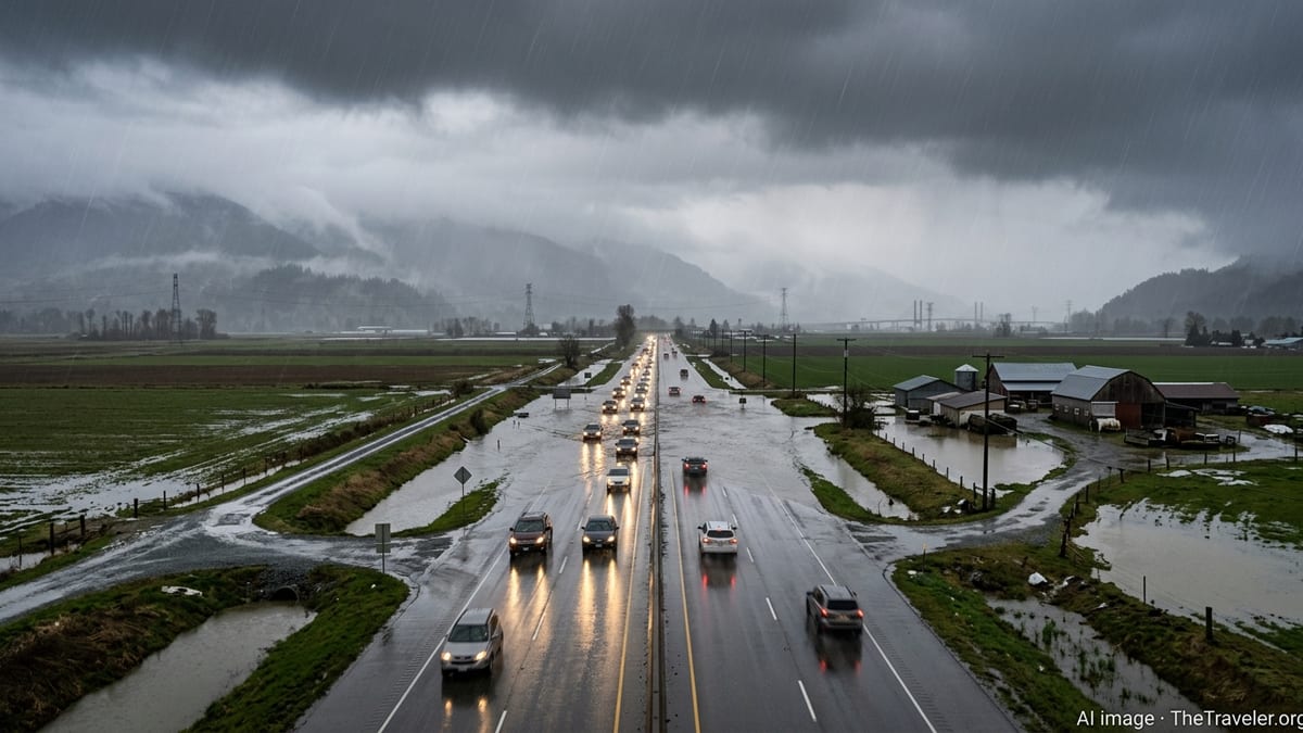
National hydrologic outlooks for spring 2026 highlight the Ohio River Basin as an area where seasonal flooding remains a normal, recurring threat, even in years without extreme snowpack or record rainfall. The latest national assessment indicates that late winter and early spring storms are once again expected to be the primary drivers of river rises across the region, with above-normal temperatures adding volatility to early-season precipitation patterns.
While the 2026 National Hydrologic Assessment does not point to widespread, unprecedented flooding in Ohio, it reiterates that travelers should anticipate periodic high water along the state’s major rivers, especially during March, April and May. Publicly available information shows that the basin routinely experiences minor to moderate flooding in these months, with localized impacts ranging from riverside park closures to access issues on low-lying roads.
Recent climate outlooks also point to an increased chance of above-normal precipitation in parts of Ohio during the critical April to June travel window. That combination of saturated soils and heavy spring downpours has the potential to convert an otherwise routine weekend getaway into a more complicated logistics exercise, particularly for visitors who book lodging or campsites within designated floodplains.
For travelers planning 2026 itineraries, the bottom line is not a blanket warning to avoid Ohio’s river country, but a clear signal that flood risk is an active factor. Understanding which destinations are most vulnerable, and how quickly conditions can change, is increasingly essential for those seeking reliable, disruption-free trips.
Ohio River Towns: Scenic Views, Repeating High-Water Headlines
Communities strung along the Ohio River, from Cincinnati eastward toward Marietta and Gallipolis, rank among the state’s most flood-exposed destinations. Historical records and recent local coverage show that stretches of riverfront in these towns regularly encounter elevated water levels that inundate parks, boat ramps and low-lying streets, even in seasons described as near or slightly above normal for flood risk.
Cincinnati’s riverfront, a magnet for concerts, restaurants and festivals, illustrates the tradeoff. In high-water episodes documented over recent years, popular green spaces and walkways have been temporarily submerged, with floodwalls and removable barriers deployed to protect nearby entertainment districts. While major impacts to hotels and core visitor infrastructure are relatively rare, recurring river crests have led to late changes in event layouts and intermittent closures of riverfront attractions.
Farther downstream, smaller tourism hubs such as Marietta and Portsmouth are more immediately connected to the river’s fluctuations. Local reporting from high-water periods in recent years has highlighted how quickly boat access can be restricted, docks can be pulled, and low-lying parking areas can be cut off. Even when gauges remain below official flood stage, rising levels can disrupt river cruises, paddling excursions and waterfront dining that many visitors build their trips around.
Travelers eyeing Ohio River getaways in 2026 face less of a catastrophic risk to lodging and more of a persistent threat to convenience and experience. The hidden danger is not necessarily a washed-out vacation, but a trip in which carefully planned riverfront activities quietly disappear from the schedule as water levels creep higher than anticipated.
Lake Erie Shores and Islands: Coastal Flooding, Seiches and Water-Quality Surprises
On Ohio’s northern edge, Lake Erie’s shoreline communities are contending with a different set of flood-related hazards. Sandusky, Marblehead and island destinations such as Put-in-Bay tap into a booming coastal tourism economy, but they also sit on a shallow, wind-sensitive lake where water levels can shift dramatically and storms can push waves and surge into marinas, ferry terminals and low-lying neighborhoods.
Hydrologic and coastal research highlights how strong winds over Lake Erie can create seiche events, in which water piles up on one end of the lake and drops on the other, rapidly altering local levels. Residents and visitors have documented episodes where harbors in the island region fell unexpectedly low or surged toward docks and breakwalls. For travelers, these swings can mean delayed ferries, temporarily inaccessible docks, or hazardous conditions for small craft and paddling excursions, even on days that began with calm weather.
Beyond direct flooding, heavy rainfall and runoff pose a second, less visible threat in the form of short-term water-quality problems. Recent statewide monitoring has found that many Ohio Great Lakes beaches have exceeded safe bacteria thresholds on at least some days during summer seasons, with storm-driven runoff and combined sewer overflows frequently cited as contributing factors. While most days remain suitable for swimming, sudden closures following intense rain can upend beach-focused itineraries with little notice.
Restoration initiatives around Sandusky Bay and other coastal wetlands aim to buffer flooding and filter runoff, and public reports indicate progress on projects that reconnect former marshland and create new natural infrastructure. Even so, these efforts coexist with expanding tourist infrastructure, roads and marinas that remain exposed to lake surges. Visitors planning Lake Erie escapes in 2026 should be prepared not only for the spectacle of big water, but also for the possibility that access, swimming and boating conditions could change within hours of a storm.
Hidden Hotspots: Inland Rivers, Creeks and Campgrounds
Some of Ohio’s most vulnerable vacation spots are not the best-known cities or resort towns, but smaller inland recreation areas along tributary rivers and creeks. Public hydrologic outlooks and local flood summaries repeatedly underscore that intense thunderstorms can create rapid rises on smaller waterways well away from the main Ohio River channel, with campgrounds, cabins and rural roadways often on the front line of such events.
Southern and southeastern Ohio, a region marketed for its rolling hills, hiking trails and rustic stays, is crisscrossed by streams that respond quickly to cloudbursts. Reports from regional weather observers and river-gauge data show that minor flooding along these tributaries can develop within hours of heavy rain, sometimes overtopping low crossings or isolating campgrounds that appeared high and dry at check-in. Because these areas may not feature the extensive floodwalls and levees seen in larger cities, the margin for error can be smaller.
The risks extend beyond tent sites. Many cabin clusters and short-term rentals are situated near creeks to capitalize on waterfront views and easy fishing access. When soils are already saturated in spring or early summer, additional storms can push those creeks over their banks, threatening access roads and parking pads even when main highways remain open. Travelers often learn about these vulnerabilities only after a booking has been made, buried in fine-print advisories or last-minute messages about potential access issues.
For 2026 travelers, the practical implication is that flood risk in Ohio is not confined to the big rivers. Inland waterways and their adjacent recreation zones can experience disruptive, and occasionally dangerous, flooding events that are poorly captured in headline forecasts, yet carry real consequences for those seeking a quiet weekend away.
Planning a 2026 Trip: How to Avoid a Flood-Damaged Vacation
With hydrologic outlooks hinting at an active precipitation pattern across parts of Ohio in 2026, travel planning increasingly hinges on understanding flood exposure before committing to dates and deposits. Publicly available federal flood maps and local planning documents outline designated floodplains along major rivers and Lake Erie’s shoreline, and independent research has highlighted that some legacy maps may underestimate future risk in a warming climate. For visitors, that underscores the value of checking more than just the brochure photos when choosing a riverfront room or campsite.
Travel experts often recommend verifying whether a property lies in or near a mapped flood zone, asking hosts about historic high-water events, and reviewing recent local news coverage for recurring issues such as access road closures or beach bacteria advisories. In Ohio’s river towns and lakefront communities, archived reports provide a useful record of how often waterfront parks close, how ferry operations respond to seiche events or storms, and whether campgrounds have had to relocate hookups and facilities away from eroding banks.
Equally important is building flexibility into 2026 itineraries. Travelers heading to Cincinnati’s riverfront or Lake Erie’s islands during peak flood and storm seasons may benefit from refundable bookings, alternate activities away from the water’s edge, and a willingness to adjust plans if forecasts shift. River-level dashboards, beach-condition reports and local weather briefings have become essential pre-trip and day-of tools rather than optional extras.
Ohio’s rivers, bays and beaches remain central to the state’s tourism identity, and many communities have invested heavily in flood defenses and shoreline improvements. Yet the underlying hydrologic reality is that high water, rapid runoff and storm-driven surges are not rare surprises, but recurring features of the landscape. For travelers in 2026, recognizing these hidden dangers in advance can be the difference between a disrupted vacation and a safe, memorable trip.