
More news on this day
The Canary Islands have endured their wettest March in more than half a century, with Storm Therese bringing torrential rain, flash flooding and landslides that have disrupted travel and tourism across some of Europe’s most popular winter-sun islands.
Get the latest news straight to your inbox!
Historic rainfall turns peak season on its head
According to published climate summaries, March 2026 is now the wettest March in the Canary Islands since at least the early 1960s, with several weather stations on Tenerife, La Palma and Gran Canaria recording unprecedented monthly totals. Meteorological data shows that high-altitude locations such as Izaña logged close to 250 litres per square metre during the month, while airports on Tenerife and La Palma also reported March records in their long-term series.
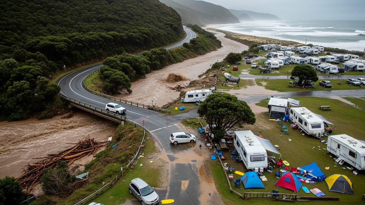
The exceptional rainfall has been closely linked to Storm Therese, which began affecting the archipelago around 19 March and repeatedly re-energised over the following days. Persistent bands of heavy rain swept across the western islands, with some areas in Gran Canaria estimated to have received more than 150 millimetres in just a few hours, overwhelming drainage systems and saturating already wet ground.
For holidaymakers, the timing could hardly have been worse. Late March typically marks a busy period for arrivals from the UK, Germany and other northern European markets, who come in search of reliable sunshine. This year, however, many coastal resorts woke up to swollen barrancos, brown surf and temporary closures instead of loungers and blue skies.
Although sea temperatures and air temperatures have remained relatively mild for the season, the intensity and persistence of the rain have reshaped the usual weather expectations. Travel industry updates describe the episode as one of the most disruptive late-winter storms to hit the islands in at least a decade.
Where holiday resorts have been hardest hit
Reports from local media and tourism-focused outlets highlight particularly severe impacts in parts of northern Tenerife and in several municipalities on Gran Canaria. Residential areas and small resort communities built along ravines and steep hillsides have seen rapid surface runoff, with water carving channels through streets and low-lying properties.
On Tenerife, coastal zones in the north, including stretches near Tacoronte and the Orotava Valley, have experienced localized flooding and damage to smaller roads that connect to rural guesthouses and villas. Visual coverage shows seawater mixing with runoff to produce turbid conditions along sections of the shoreline, prompting temporary suspension of water-based excursions in some areas.
Gran Canaria has also faced notable disruption around Agaete and other communities exposed to overflowing reservoirs and fast-flowing ravines. Publicly available information indicates that several dams on the island have operated close to capacity after days of intense rain, with controlled releases sending additional volumes of water down already swollen channels that pass near residential zones and accommodation areas.
Elsewhere in the archipelago, La Palma, La Gomera and El Hierro have seen landslides and rockfalls on mountain roads, complicating access to trekking routes and nature-based lodgings that are popular with independent travellers. While the main resort belts in southern Tenerife, southern Gran Canaria, Fuerteventura and Lanzarote have generally fared better, they have still contended with spells of heavy rain, strong winds and rough seas that have limited outdoor activities.
Travel, transport and safety: what visitors are experiencing
Published coverage from regional news outlets points to widespread disruption to internal transport rather than a complete shutdown of tourism. Inter-island flights have mostly continued to operate, although some services have faced delays or schedule changes during periods of the heaviest rain, low cloud or strong crosswinds. Travellers with tight connections have been advised by airlines and tour operators to allow flexibility and monitor updates in real time.
On the ground, the storm’s main impact has been on road networks. Landslides, fallen rocks and localized flooding have led to the temporary closure of a number of secondary and mountain roads, particularly on Tenerife, Gran Canaria and La Palma. Iconic scenic routes and access roads to highland viewpoints have been among the most affected, limiting opportunities for day trips into the islands’ interiors.
For visitors staying in established resort areas, the experience has tended to involve periods of heavy rain, strong gusts and intermittent power interruptions, rather than sustained danger. Larger hotels and apartment complexes are typically built with substantial drainage and stormwater systems, and many have shifted quickly to indoor entertainment programmes while outdoor pools and terraces are periodically closed for safety.
Nevertheless, travellers moving around independently, especially those driving rental cars on lesser-known routes or hiking on unofficial trails, have encountered more significant challenges. Emergency notices emphasize the risk of sudden rockfalls, collapsed verges and fast-rising waters in ravines, and caution against attempting to cross flooded roads or walk through watercourses even when the rain appears to ease.
Practical advice for current and upcoming visitors
Tourists currently in the Canary Islands or due to arrive in the coming days are being encouraged, through tourism boards and local media, to stay informed rather than cancel trips outright. With core infrastructure functioning and major airports and ferry ports open, the islands remain accessible, but conditions can vary sharply between the leeward and windward sides of each island and between coastal and highland zones.
Before travelling, visitors are advised to check airline or tour operator channels for any schedule adjustments and to verify transfer arrangements from the airport, especially if staying in rural accommodation that relies on minor roads. Travel insurance policies should be reviewed to confirm coverage for weather-related disruption, including the possibility of extended stays if flights are delayed.
Once on the islands, keeping abreast of official weather advisories and local council announcements can help travellers choose safe activities each day. In practice, this may mean prioritizing attractions in more sheltered southern coastal areas, opting for urban sightseeing when rainfall peaks, and postponing highland hikes or canyon excursions until authorities declare slopes stable and trails clear.
Guests should also expect some ongoing visual and operational impacts, such as closed sections of promenade, temporary beach access restrictions near damaged infrastructure, or diversions around clean-up works. Patience with staff and service providers, who are balancing regular tourism operations with post-storm repairs, will go a long way toward ensuring a smoother stay.
Looking ahead: recovery, water reserves and climate context
As the immediate threat from Storm Therese recedes, attention across the Canary Islands is turning to damage assessment and recovery. Municipalities are tallying costs linked to eroded roads, damaged retaining walls, flooded ground floors and affected coastal infrastructure that supports restaurants, bars and water sports operations serving visitors.
At the same time, the rains have transformed the islands’ precarious water situation. Local reporting notes that reservoir levels in Gran Canaria have multiplied several times over compared with pre-storm volumes, while other islands have also seen a substantial recharge of dams and aquifers after several dry years. For residents, this offers a degree of reassurance ahead of the hot, dry months, even as short-term flooding impacts remain fresh.
Climate specialists quoted in open reports frame the March 2026 episode within a broader pattern of more frequent and intense heavy-rainfall events affecting subtropical regions. The combination of warmer air masses capable of holding more moisture and stalled low-pressure systems has increased the likelihood of storms that deliver extreme precipitation over short periods, particularly over mountainous islands.
For tourism planners and businesses, the latest events are likely to reinforce efforts to adapt resort infrastructure and marketing to a future in which once-rare extremes may occur more often. That could include investing further in drainage, slope stabilization and early-warning systems, as well as communicating more clearly with visitors about seasonal weather variability, so that holidays in the “land of eternal spring” remain both enjoyable and safe, even when the skies briefly resemble the North Atlantic rather than the subtropics.