
More news on this day
Red Flag Warnings and critical fire danger are in effect across much of Oklahoma on Tuesday, February 24, as unseasonably warm temperatures, low humidity and gusty winds combine to create explosive wildfire conditions that travelers and residents cannot ignore.
Where Red Flag Warnings Are in Effect Today
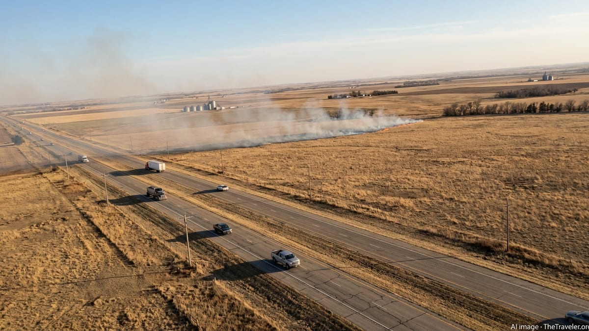
On February 24, large portions of western and southwestern Oklahoma find themselves under Red Flag Warnings, with fire danger extending into central parts of the state and the wider Texoma region. Local meteorologists report temperatures climbing into the mid to upper 70s, paired with dry air and persistent breezes, a combination that sharply elevates the risk of fast-moving grass and brush fires.
Television stations in Lawton and other southwest Oklahoma communities note that the warning covers most of the Texoma area through this evening, capturing key travel corridors and popular stopover towns used by road-trippers crossing the Southern Plains. The warning area includes stretches of interstate and U.S. highways that link Oklahoma City with the Texas Panhandle and northwestern Oklahoma, where recent wildfires have already burned hundreds of thousands of acres.
Even counties not under a formal Red Flag Warning are facing elevated fire weather concerns, as a warm, dry pattern lingers over the Southern High Plains. Officials caution that conditions can deteriorate quickly during the warmest part of the afternoon, so travelers may experience rapidly changing advisories as they move across the state.
Neighboring states share similar conditions, with critical fire weather discussed for the Texas and Oklahoma Panhandles and parts of Kansas and New Mexico. For anyone planning regional road trips or multi-state drives, Oklahoma sits in the heart of a broader belt of heightened fire risk this week.
Why Fire Danger Is So High Right Now
The Red Flag Warnings arriving today in Oklahoma are the product of several factors that have aligned over the past week. A run of warm, dry days has left grasses and brush extremely receptive to ignition, while strong and gusty winds are helping any fire that does start to spread quickly across open rangeland and agricultural fields.
Meteorologists describe a pattern typical of late winter and early spring in the Southern Plains, when strong weather systems passing to the north can pull in very dry air and intensify winds. This year, that setup is overlapping with a wildfire season that has already been active. The large Ranger Road Fire, burning since February 17 in northwestern Oklahoma and southern Kansas, has scorched more than 280,000 acres and underscored how quickly fires can outrun containment efforts in these conditions.
Forestry and fire officials across the Southern Plains have responded by activating regional wildfire compacts, allowing crews and equipment to move rapidly across state lines as demand surges. Oklahoma’s own forestry agency has warned that this season could rival or even exceed the dangerous fire activity seen in 2025, particularly in western counties that have a long history of wind-driven grassfires.
For travelers, this setup means that what starts as a routine warm, breezy day on the road can quickly turn into a high-impact event, with smoke plumes suddenly visible on the horizon and new travel alerts or detours popping up along planned routes.
Travel Impacts: What Visitors May Encounter
As Red Flag Warnings expand across Oklahoma, the most immediate impact for travelers is the potential for rapidly changing visibility and road conditions. Large grassfires in the region over the past week have forced temporary highway closures and created smoke that reduced visibility to dangerous levels, especially in rural stretches with limited alternate routes.
Drivers may encounter roadside electronic signs warning of fire activity, active detours around affected corridors, or law enforcement checkpoints preventing entry into threatened areas. In extreme cases, officials can close portions of interstate highways if smoke and blowing dust combine to create whiteout-like conditions, a risk that increases when wind gusts climb above 40 or 50 miles per hour.
Air travelers heading to or from Oklahoma City, Lawton and regional airports are less likely to see widespread flight disruptions, but they may notice aerial firefighting activity, including tankers and helicopters staging from nearby facilities. Smoke from large fires can occasionally create haze over broad areas, subtly affecting views on approach and departure.
Those staying in rural lodges, ranch stays or state park cabins should be prepared for localized evacuations if a nearby wildfire changes direction. Hotel guests in small towns could see an influx of evacuees and firefighters, tightening room availability on short notice in the hardest-hit areas of western and northwestern Oklahoma.
Safety Guidance for Travelers and Outdoor Visitors
During a Red Flag Warning, the most important message from Oklahoma emergency managers is simple: avoid any activity that could spark a fire. That includes discarding cigarette butts from vehicle windows, pulling a hot vehicle off onto tall grass at rest stops, or dragging trailer safety chains that can send off sparks along the pavement. In these conditions, even a small ignition source can trigger a fast-spreading grassfire.
Campers and RV travelers are urged to check local fire regulations before lighting any campfire or using charcoal grills, and in many counties such activities may be temporarily restricted or banned. Even where open flames are technically allowed, officials recommend using propane stoves on cleared, nonflammable surfaces and fully extinguishing any heat source before leaving a campsite or picnic area.
Hikers and photographers exploring Oklahoma’s plains, canyons and wildlife areas should remain alert for smoke on the horizon and pay attention to wind direction. If smoke becomes stronger or appears to be moving toward your location, the safest choice is often to return to a vehicle and move back toward larger, well-signed roads where emergency updates are more readily communicated.
Travelers with respiratory sensitivities may want to keep masks or respirators on hand, as wind shifts can quickly bring smoke into communities many miles from an active fire line. Keeping vehicle windows closed, recirculating cabin air and monitoring local weather broadcasts can help reduce exposure and keep you informed about changing fire conditions.
How to Stay Informed as Conditions Evolve
With fire weather advisories changing from hour to hour, staying informed is crucial for anyone traveling through Oklahoma during this heightened risk period. Local National Weather Service offices in Norman, Tulsa and surrounding regions issue Red Flag Warnings, Fire Weather Watches and updates on critical fire weather, which are quickly picked up and relayed by television and radio outlets across the state.
Travelers should monitor local broadcasts when entering a new part of the state, as county-based warnings can be highly specific, targeting only the areas where winds, humidity and fuels combine to pose the greatest danger. Smartphone weather apps and wireless emergency alerts can also provide push notifications when a new warning or evacuation order is issued near your current location.
For those planning multi-day road trips, checking the fire weather outlook each morning and evening can help identify the safest windows for long drives across exposed prairie or ranchland. If forecasts show critical fire weather aligning with your route and travel time, consider adjusting departure by a few hours or choosing a more easterly or northerly path that skirts the highest-risk zones.
Although Red Flag Warnings are expected to ease somewhat when a cooler air mass eventually arrives, forecasters caution that Oklahoma’s fire season is far from over. Even after current warnings expire, travelers in the state through late winter and early spring should remain mindful that high fire danger can return quickly whenever warm, dry and windy conditions reappear.