
More news on this day
Severe thunderstorms and flash flooding across multiple regions of the United States on March 31, 2026, triggered 3,141 flight delays and 117 cancellations, straining an already fragile aviation network and leaving thousands of travelers facing missed connections, overnight stays and rapidly changing itineraries.
Get the latest news straight to your inbox!
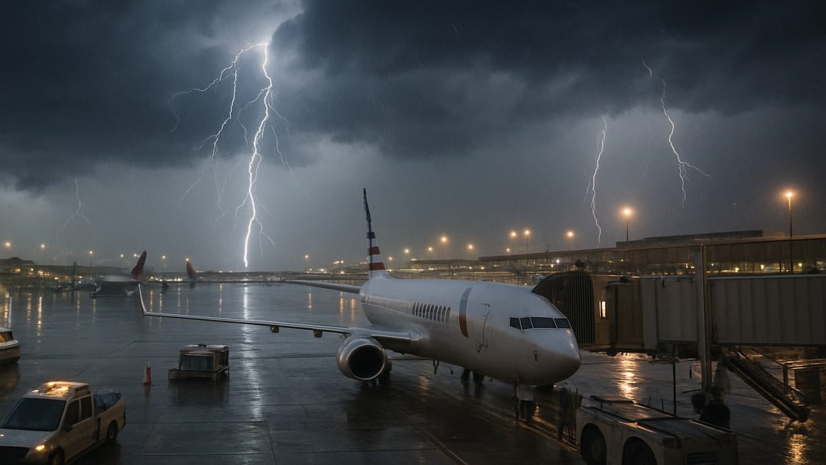
Image by nomadlawyer.org
Storm Cells Stall Major Hubs and Regional Airports
Publicly available aviation data and media reports indicate that the latest round of storms swept through key Midwestern and Southern corridors, disrupting flight operations from Chicago and Columbus to New Orleans and Norfolk. The combination of intense downpours, lightning and low cloud ceilings impeded takeoffs and landings, forcing airlines and air traffic managers to slow the flow of aircraft into already busy airspace.
Chicago O’Hare and Midway emerged as early flashpoints, where ground stops and subsequent ground delay programs sharply reduced arrival rates. Local television coverage from Chicago cited hundreds of delayed flights and more than an hour of average holdups at O’Hare as thunderstorms rolled through the metro area, underscoring how a single storm band can ripple through national schedules.
Further south, storms and flash flood advisories around the Gulf Coast added to the mounting disruption. Travel-focused industry outlets reported disruption at airports serving New Orleans and other coastal cities, where saturated ground conditions made ramp operations slower and more constrained. These regional chokepoints contributed to the national tally of 3,141 delays and 117 cancellations within, into or out of the United States.
Inland, airports in cities such as Columbus and Norfolk experienced their own localized surges in delays, reflecting how even secondary hubs can quickly become bottlenecks when convective weather clusters move along heavily traveled routes.
Thunderstorms, Flash Floods and the Limits of Airport Capacity
Meteorological assessments show that the system producing the latest round of disruption combined slow moving thunderstorm clusters with periods of torrential rain, elevating flash flood risks on and around airport properties. In parts of Texas and Oklahoma, similar patterns of training thunderstorms in recent days inundated roadways and temporarily grounded flights at major airports including Dallas Fort Worth and Dallas Love Field, offering a preview of the challenges now spreading through other regions.
Flash flooding can quickly overwhelm drainage systems near runways and taxiways, prompting temporary closures of sections of the airfield, while lightning within a defined radius typically halts ramp work for safety reasons. These measures protect ground crews and aircraft but reduce the rate at which planes can be turned, boarded and dispatched, setting off waves of downstream delays.
Aviation and weather research routinely identifies convective storms as a leading driver of air traffic disruption in the United States. Even short bursts of severe weather can have outsized effects during peak periods because arrival and departure slots are tightly scheduled. When a line of storms crosses a major hub during the afternoon or early evening, recovering the schedule often requires hours of metered flows and, in some cases, strategic cancellations to rebalance aircraft and crews.
In this latest episode, the relatively low number of cancellations compared with the much higher delay count suggests that many airlines opted to operate flights on extended timelines rather than remove them from the schedule entirely, a pattern that can keep travelers moving but also increases the risk of missed connections late into the day.
Airlines Juggle Delays Across Mainline and Regional Fleets
Breakdowns of airline performance published by industry news outlets show that the disruption was spread across a mix of large network carriers, low cost airlines and regional operators. Mainline brands such as United, American and Southwest reportedly recorded relatively few outright cancellations but logged several hundred delays each as storms rolled through their networks.
Regional affiliates and contract carriers, including Envoy, SkyWest, Horizon and others, appeared to shoulder a disproportionate share of the schedule volatility. These operators often serve as feeders into large hubs, and delays on shorter routes can quickly propagate when aircraft and crews are needed for onward legs. A single weather induced hold at a smaller city can therefore echo through multiple itineraries by evening.
Some budget and ultra low cost airlines were particularly delay heavy, with publicly available tallies indicating hundreds of late departures despite only isolated cancellations. That pattern is consistent with business models that prioritize completing as many flights as possible, even if departure times slip, in order to avoid large backlogs of displaced passengers.
At the same time, the day’s operations unfolded against a backdrop of broader capacity and staffing constraints. Previous reporting from travel and aviation outlets has highlighted ongoing tight staffing at some security checkpoints and among airline workforces, conditions that can constrain recovery options when storms compress schedules into narrower operating windows.
Knock-on Effects for Travelers Across the U.S.
For passengers, the numerical tally of 3,141 delays and 117 cancellations translated into crowded terminals, long lines at rebooking desks and shifting arrival times across the country. Hubs such as Chicago, Atlanta and Boston reported residual delays into the evening as aircraft and crews repositioned to resume normal patterns.
Travel coverage noted that some of the hardest hit routes connected major business and leisure markets, including corridors linking Midwestern cities with coastal destinations. Misaligned aircraft rotations meant that travelers who did depart often encountered gate changes and revised boarding times, extending the day’s uncertainty.
Reports also indicate that road and rail travel options were not always reliable substitutes in regions experiencing flash flooding, particularly where water covered access roads leading to airports. In such cases, even travelers whose flights operated close to schedule faced challenges simply reaching the terminal.
Travel advisers and consumer advocates routinely recommend that passengers monitor airline apps, enroll in flight status alerts and keep essential items such as medication and a change of clothes in carry on bags during periods of unsettled weather. The latest disruption is likely to reinforce those habits among travelers caught in the cascading effects of the storms.
What the Latest Disruption Signals for the Coming Season
The March 31 event arrives ahead of the traditional peak summer thunderstorm season, offering an early indication of how vulnerable the aviation system remains to clusters of severe weather. Recent storm related disruptions, including separate systems that produced deadly flooding in parts of Oklahoma and Texas and prompted large scale delays along the East Coast earlier in March, have underscored the growing intersection between extreme weather and transportation reliability.
Industry analysts point to investments in weather forecasting tools, air traffic flow management and airport drainage improvements as critical to mitigating future shocks. Nonetheless, as convective events intensify or occur more frequently in some regions, the ability of airports and airlines to absorb disruptions without large waves of delays may be tested repeatedly.
For now, the figures from March 31 highlight how a few hours of severe thunderstorms and flash flooding can paralyze key segments of the U.S. aviation grid, even on a day with relatively modest cancellation numbers. With the busy spring and summer travel period approaching, travelers and airlines alike are likely to be watching forecasts as closely as timetables.