
More news on this day
Thailand is bracing for a burst of extreme summer storms this week, as meteorologists warn that torrential thunderstorms, powerful gusts, and pockets of hail are likely to sweep across upper regions from February 23 to 25, threatening travel disruption and prompting urgent safety advisories for residents and visitors.
New Weather Alerts as Hot Season Officially Begins
The Thai Meteorological Department has issued a series of warnings for what it calls the first significant summer storm system of 2026, coinciding almost exactly with the formal onset of the country’s hot season on February 22. A clash between a cold air mass pushing in from China and increasingly hot, unstable air over Thailand is creating ideal conditions for violent convection.
The storms are forecast to intensify over upper Thailand between February 23 and 25, beginning in the Northeast before spreading to the North, Central Plains, Bangkok and surrounding provinces, and parts of the East. Officials say the volatile setup could trigger widespread thunderstorms, bursts of torrential rain, damaging straight line winds, frequent lightning, and isolated hail.
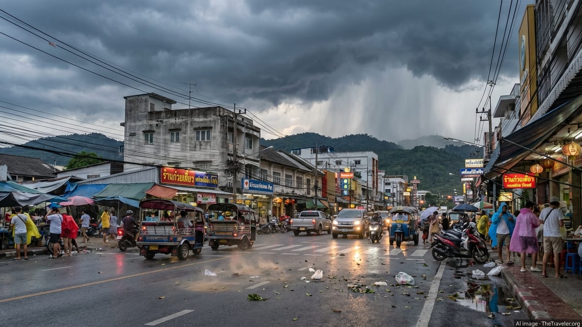
Authorities stress that these storms are not associated with a tropical cyclone but with a classic late February transition pattern, as the country pivots from the cool season to months of searing heat. That combination, forecasters say, can produce short lived but intense squalls capable of toppling trees, peeling off roofs, and disrupting transport on land and in the air.
Upper Regions in the Crosshairs, With Hail and Gusts Likely
The highest risk zone covers much of upper Thailand, including all northern and northeastern provinces and most of the Central region, with Bangkok and its vicinity explicitly named in alerts. Disaster management authorities have flagged around 60 provinces for heightened vigilance, citing the risk of very localized but severe weather cells within the broader storm belt.
In the North, recent radar scans have already shown clusters of thunderstorms forming over Chiang Mai, Chiang Rai, Lamphun, Lampang, Tak, and surrounding provinces, with at least one storm producing a noticeable fall of hail that startled residents in rural Chiang Mai over the weekend. In the Northeast, Nakhon Ratchasima has reported strong winds and chaotic scenes at local markets as vendors hurried to secure stalls ahead of darker skies.
Forecasters warn that while rain totals may be uneven, any storm that does form could rapidly intensify, bringing brief periods of blinding rain, violent gusts, and hailstones large enough to damage roofs, vehicles, and crops. Lightning activity is also expected to be frequent, adding another layer of danger in exposed or rural areas.
Travel Disruptions Possible on Roads, Rails, and in the Air
For travelers, the timing of the storms could complicate journeys across some of Thailand’s busiest overland and air corridors. Heavy downpours and sudden crosswinds are likely to impact highways linking Bangkok with the Northeast and North, with authorities warning of reduced visibility, slick surfaces, and the possibility of fallen branches or power lines blocking secondary roads.
Rail operations typically continue through summer storms, but strong winds and debris on the tracks can lead to speed restrictions and delays. Travelers heading to or from major northern and northeastern cities by train are being advised to allow extra time in case of schedule adjustments during the peak storm window.
Airports in affected regions, including Bangkok, Chiang Mai, and northeastern hubs, are preparing for potential disruption. Thunderstorms near approach and departure paths can force temporary holds, diversions, or ground stops, particularly during late afternoon and evening hours when heating driven storms tend to be most vigorous. Airlines are encouraging passengers to monitor flight status closely, arrive early, and expect that sudden weather changes may trigger last minute operational decisions.
Urban commuters, especially in Bangkok, could also face localized flooding and traffic snarls if intense downpours coincide with peak travel times. Storm drains clogged with seasonal debris can quickly become overwhelmed, with standing water adding to congestion and the risk of motorbike accidents.
Officials Urge Precautions as Disaster Teams Stand By
The Department of Disaster Prevention and Mitigation has activated heightened monitoring protocols and positioned rapid response units across at risk provinces. Local authorities have been instructed to check the stability of billboards, power poles, and other vulnerable structures, and to prepare temporary shelters in case of damage to homes in more exposed communities.
Residents and visitors are being urged to stay indoors when thunderstorms approach, avoid open fields, hilltops, and large trees, and keep away from flimsy structures and roadside signage that could collapse in sudden gusts. Officials also advise unplugging non essential electrical devices during intense lightning activity and refraining from using metal framed outdoor shelters at the height of a storm.
Farmers in upper Thailand have been told to reinforce trellises and supports for fruit trees and cash crops, move livestock to sheltered enclosures, and secure loose equipment that could become airborne in high winds. Even short lived hailstorms can strip leaves, bruise fruit, and flatten tender crops, making early preventive measures critical at this stage of the growing season.
Disaster response centers are reminding the public to follow updates from national meteorological and emergency agencies rather than relying solely on social media posts, which can sometimes spread outdated or inaccurate information during rapidly changing weather events.
What Tourists in Affected Areas Should Do Now
Tourism operators across northern and northeastern Thailand, as well as in Bangkok, are adjusting plans in expectation of unsettled skies. Outdoor excursions, hiking trips, and open air cultural activities may be rescheduled or shortened when storm cells are nearby, while some viewpoint or rooftop venues could temporarily close during periods of high wind or lightning.
Visitors are being advised to build extra flexibility into their itineraries for February 23 to 25, particularly if they plan to move between regions by bus, train, or domestic flight. Travel planners recommend avoiding tightly stacked connections, especially in the late afternoon and evening when storms are most likely, and keeping hotel check in or tour start times reasonably loose.
Practical steps for travelers include carrying a compact rain jacket rather than relying on disposable ponchos, which can tear easily in strong winds, and choosing closed footwear with good grip for navigating wet pavements. Those staying in guesthouses or smaller hotels in rural areas should check that windows close securely and that balconies or terraces are cleared of loose items that might be blown away.
Above all, both residents and tourists are being encouraged to treat this week’s storms as a serious but manageable seasonal hazard. By monitoring official forecasts, allowing extra time for journeys, and taking simple precautions against high winds, hail, and lightning, people across upper Thailand can reduce their risks while the country rides out its first major weather test of the 2026 hot season.